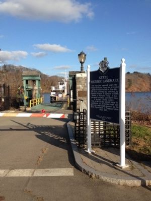
On Ferry Road (U.S. 148), on the right when traveling east.
For over two hundred years the Chester-Hadlyme Ferry has provided public transportation at this site. The first crossing was initiated by Johnathan Warner of Chester in 1769. Known as Warner's Ferry, it was privately operated until 1877 when it . . . — — Map (db m61345) HM
On Ferry Road, on the left when traveling west on Ferry Road.
(Upper middle photo)
At one time, the town of Chester had three train stations: (from south to north) Chester, North Chester, and Hadlyme-all of which would have been within sight of this location looking south.
This location is the . . . — — Map (db m266484) HM
On Main Street at Water Street (Connecticut Route 148), on the left when traveling west on Main Street.
Chester
Chester is located on land known as Pattaconk or Pattyquounck in Indian deeds of the 1660's. Settled largely by families from Saybrook, it became the Fourth Ecclesiastical Society of the Saybrook Congregational Church in 1740 and was . . . — — Map (db m100313) HM
On Middlesex Turnpike (Connecticut Route 154) at Railroad Avenue, on the right when traveling north on Middlesex Turnpike.
There Was A Time
When The World Asked
Ordinary People
To Do
Extraordinary Things
To The Man and Women of Chester
Who Served Our Country
Dedicated
May 2004
( left panel )
World War II
Kern, Frederick A. • Walden, Francis . . . — — Map (db m65998) WM
On Middlesex Turnpike (Connecticut Route 154) near Railroad Avenue, on the right when traveling north.
In honor of the men of Chester
who served in the World War
1917 - 1918
Abbey Raymond C. • Bailey Charles F. • Beckwith Willis A. • Berg Albert • Bergonzi Joseph • Bickerton Charles W. • Bocksruth John H. • Bole John J. • Brooks Malcolm G. • . . . — — Map (db m66000) WM
On Middlesex Turnpike (Connecticut Route 154) at Railroad Avenue, on the right when traveling north on Middlesex Turnpike.
Honoring All Who Served
World War II 1941 1946
These Gave Their Lives
George A. Butler • Allen W. Burton • Theodore P. Dreher • Arthur Going • Philip H. Kern • Anthony P. Narducci • Harold M. Perry • Richard L. Turner • George E. Watrous • . . . — — Map (db m65999) WM
Near East Main Street (U.S. 1) at Cemetery Road, on the right when traveling east.
You are standing beside the Indian River in the heart of the 1663 settlement of Killingworth, sited on its protective harbor. In 1838, the shoreline portion parted from northern Killingworth and became Clinton.
Shipbuilding
The first . . . — — Map (db m100187) HM
On East Main Street (U.S. 1) just west of Cemetery Road, on the right when traveling west.
1. Congregational Church
This Classic Rivival sanctuary dates from 1837 and is the fourth church building to have been located on Meeting House Hill. In front of the church stands in the monument honoring Abraham Pierson and the . . . — — Map (db m227288) HM
On East Main Street (U.S. 1) just east of Cemetery Road, on the right when traveling east.
1. Indian River
At the center of the Colonial settlement, this stream winds south through salt marshes to the harbor. Shipyards stood on its banks in the 18th and 19th centuries. The bridge dates from the 1876, replacing an an earlier . . . — — Map (db m227290) HM
On West Main Street (U.S. 1) at Hull Street ( Route 81), on the right when traveling west on West Main Street.
On this approximate location
Abel Buell
had his goldsmith shop from
1763 - 1769
Inventor, artist, engraver,
cartographer, engineer, pattern maker, lapidary,
silversmith, die cutter, type founder,
and master of many trades. . . . — — Map (db m269315) HM
On East Main Street (U.S. 1) at Morgan Park, on the left when traveling east on East Main Street.
In Honor of
The Good and Learned
Abraham Pierson
First President
of
Yale College 1701-1707
Pastor of Killingworth Church
Now Clinton 1694-1707
The Time of His Death
Beloved and Regretted
By All.
( east side )
Erected By . . . — — Map (db m100188) HM
On E Main St (U.S. 1) at Commerce St, on the right when traveling north on E Main St.
U.S. Army Staff Sgt. Ryan C. Knauss, 23, Corryton, Tennessee
U.S. Navy, Hospital Corpsman Maxton W. Soviak, 22, Berlin Heights, Ohio
U.S. Marine Staff Sgt. Darin T Hoover, 31, Salt Lake City, Utah
U.S. Marine Sgt. Nicole L. Gee, 23, . . . — — Map (db m260539) WM
On Old Post Road (Connecticut Route 145) north of Carriage Drive, on the right when traveling north.
"This monument is to honor all Veterans and their families who put their country first so that today everyone can enjoy freedom, liberty and democracy." — — Map (db m253095) WM
On East Main Street (U.S. 1) at Cemetery Road, on the right when traveling east on East Main Street.
Settled in 1663 and then known as Homonoscitt Plantation, this shoreline and rural community soon thereafter was given the name Kenilworth and later Killingworth. In 1735 the First and Second Ecclesiastical Societies were established being the . . . — — Map (db m100158) HM
On East Main Street (U.S. 1) at Liberty Street, on the left when traveling east on East Main Street.
Erected by
The Women’s Relief Corps
and the citizens of Clinton
in memory of the soldiers
and sailors who fought
to preserve the Union.
1861 – 1865
For the dead a tribute,
for the living a memory,
for posterity an emblem
of . . . — — Map (db m100190) WM
On East Main Street (U.S. 1) just west of Cemetery Road, on the right when traveling west.
In honor of the founding of the Homenossitt Plantation which grew and prospered and became the Town of Clinton.
The week of July 28 - August 4, 1963 was set set aside for a townewide celebration embracing the many events of Clinton's . . . — — Map (db m227289) HM
On East Main Street (U.S. 1) at Cemetery Road, on the right when traveling east on East Main Street.
The People Of Clinton Honor Those Who Served Their Country
These Are They That Gave
Their Lives · · That Men
Might Live In Freedom
World War I
Kozlik, Henry · Stevens, Giles F. · Hilliard, Howard G.
World War II
Burnes, Edward J. · Jones, . . . — — Map (db m100159) WM
On East Main Street (U.S. 1) at Cemetery Road, on the left when traveling east on East Main Street.
Dedicated to all of the men and women
Who gave their lives
For our country
Beneath this plaque are the ashes from
600 retired American Flags
More than 500 of these flags served in
the “Field of Flags”, each one . . . — — Map (db m100186) WM
On East Main Street (U.S. 1) just east of Waterside Lane, on the right when traveling west.
On August 21, 1824, General Lafayette, traveling on the Post Road, was welcomed with military and civil honors in Killingworth, now Clinton. — — Map (db m245608) HM
On Cow Hill Road at Airline Road, on the right when traveling south on Cow Hill Road.
The American Liberty elm was named after "The Liberty Tree": Our Country's First Symbol of Freedom. On the morning of August 14, 1765, the people of Boston awakened to discover two effigies suspended from an elm tree in protest of the hated Stamp . . . — — Map (db m264943) HM WM
On E Main Street (U.S. 1) at Church Road, on the right when traveling east on E Main Street.
This replica of the milestone placed here in the mid 1700s marks 25 miles to New Haven. Benjamin Franklin, then Colonial Postmaster General, determined the sites of these markers along the Post Road connecting New York and Boston.
Clinton . . . — — Map (db m242980) HM
Near Waterside Lane south of Old Harbor Village, on the right when traveling south.
The Great Hammock Salt Marsh and Clinton Harbor
The Town of Clinton, originally a part of Killingworth, was settled in 1663 by families, many of whose descendants still live here. Those first settlers found much evidence of Native American . . . — — Map (db m245079) HM
Near Osprey Commons South east of Beach Park Road, on the right when traveling east.
The Work of the Salt Marsh
You are standing at the edge of an ancient marsh, above layers of peat forty feet deep. Once an inland freshwater lake, the Hammock estuary is now flooded twice daily by nutrient-rich salt tides.
Tidal salt . . . — — Map (db m272470) HM
(frontside)
Tomb Of
The Unknown
Soldier
Erected By The Townspeople Of Clinton In Memory Of Those Who Died In The Service Of Their Country And Whose Identity Was Never Established
Memorial Day 1978
(backside)
Tomb Of
The . . . — — Map (db m260494) WM
Near Waterside Lane south of Old Harbor Village, on the right when traveling south.
Clinton's Defense Against the British
During the War of 1812, Clinton, then called Killingworth, was under the threat of attack from the British. There were shipyards located on both the Indian River and in the harbor, and the British had . . . — — Map (db m243716) HM
On East Main Stre (U.S. 1) at Cemetery Road, on the left when traveling east on East Main Stre.
The Earliest Senior Classes Of
Yale College
Were Taught Near This Spot By
Rector Abraham Pierson
1701 to 1707
( inscribed around the top )
I Give These Books For Founding A College
( back )
In Memoriam
Abraham Pierson . . . — — Map (db m100160) HM
On Main Street at North Main Street ( Route 602), on the left when traveling east on Main Street.
Originally part of the Saybrook colony, the area now known as Ivoryton was annexed with the newly formed Essex in 1859. Thought of as the “wild country,” it soon developed into a prosperous manufacturing village. In the late 1700’s Phineas Pratt . . . — — Map (db m100239) HM
On Colchester Avenue (Connecticut Route 16) at Browns Mill Road, on the right when traveling north on Colchester Avenue.
Comstock Covered Bridge
Built in 1873 by the Towns of Colchester and East Hampton
The Comstock Covered Bridge is one of only three historic covered bridges remaining in Connecticut. With a main span 80 feet in length (measured . . . — — Map (db m310615) HM
On West Street near Allen Place, on the right when traveling south.
Cromwell
This area was settled in 1650 as a rural-farming community known as Middletown Upper Houses. It was incorporated and named Cromwell in 1851. The 18th century saw a thriving riverport. followed by brownstone quarrying and several factories . . . — — Map (db m99538) HM
On Main Street (Connecticut Route 99) at South Park Street, on the right when traveling south on Main Street.
Erected in Honor
of
The World War Veterans
by
The Citizens Of
Cromwell
1925
Helen Abel · Jessie T Abel · Amato Giovanni · Anderson Harry J · Anderson Albert C · Anderson Carl A · Anderson Thomas E · Austin Millard B · Barrows Cadella I . . . — — Map (db m99539) WM
On Main Street (Connecticut Route 99) at Wall Street, on the left when traveling south on Main Street.
Middletown Upper Houses
1650
Founders 1650 — 1680
John Clark · Samuel Hall · John Kirby · Anthony Martin · Thomas Renney · David Sage · John Savage · Samuel Stocking · Thomas Stow · John Warner · Nathaniel White · John Wilcox . . . — — Map (db m99547) HM
On Main Street at Prospect Hill Road, on the right when traveling north on Main Street.
In honor of those who served
(sign)
Dedicated July 4, 1973 to the Korean & Vietnam veterans
(individual stones not transcribed) — — Map (db m300410) WM
On Main Street (Connecticut Route 154) at Lafayette Avenue, on the right when traveling north on Main Street.
Columbia, painted by C.D. Batchelor, Pulitzer Prize winning cartoonist, was dedicated by Gov. Raymond Baldwin in Nov. 1943 on the library grounds. By 1969 weather-time had caused decay in the wooden frame. A committee was formed to relocate and . . . — — Map (db m65684) HM WM
On Main Street (Connecticut Route 154) at Lafayette Avenue, on the right when traveling north on Main Street.
Deep River Roll Of Honor - World War I
1917 – 1918
Ahlstrin, Elmer • Bahr, Herman G. • Bartman, Kenneth E. • Berg, Albin • Berg, Gustaf R. • Berg, Philip • Berg, Hjalmer • Berdensey, Arthur • Bsong, Michael • Bowie, Edward • Caples, Jesse . . . — — Map (db m65948) WM
On Main Street (Connecticut Route 154) at Lafayette Avenue, on the right when traveling north on Main Street.
Deep River Roll Of Honor
Our Country Tis Of Thee
( left panel ) Korea
25 Jun 1950 31 Jan 1955
John J Ziobron • Oscar A Buracchi • Donald G Hines • Vincent E Nucci • David C Turner • Anthony E Calarco • Robert C Benson • Richard H . . . — — Map (db m135523) WM
On Main Street (Connecticut Route 154) at Lafayette Avenue, on the right when traveling north on Main Street.
In Memoriam
Erected By
The Citizens of This Town
In Honor Of
Her Patriotic Men and Women
Who Served Their Country
In Time of War
To The Dead - A Tribute
To The Living - A Memory
To Posterity – An Emblem Of Loyalty
To The . . . — — Map (db m65949) WM
On Main Street (Connecticut Route 154) at Winter Avenue, on the right when traveling north on Main Street.
The Underground Railroad
Led by George Read, Founder of the Town’s Ivory Industry, Deep River Became Known in the Nineteenth Century as "All Abolitionist" and a Refuge for Runaway Slaves on the Underground Railroad. In 1828, Daniel Fisher, a . . . — — Map (db m100312) HM
On Middlesex Turnpike (Connecticut Route 154) at Elm Street, on the left when traveling north on Middlesex Turnpike.
We Honor the Elephant
During the 1800’s Deep River was the center of America’s ivory trade. Elephant tusks from Africa were brought to Deep River landing for local factories to make piano keys, combs, buttons, and billiard balls. Up to 100,000 . . . — — Map (db m100244) HM
Near Main Street (Connecticut Route 17) 0.1 miles west of Fowler Road, on the left when traveling north.
Dedicated to the men and women of the total force who supported and defended the Constitution of the United States and the State of Connecticut — — Map (db m94733) WM
On Main Street (Connecticut Route 17) at Fowler Road, on the left when traveling north on Main Street.
Durham
Coginchaug or “Long Swamp” was purchased from the Indians in 1673. A town plot was laid out in 1699, named Durham five years later, under a patent from King Charles II, and was confirmed by the General Assembly in 1708. It was . . . — — Map (db m94697) HM
On Main Street (Connecticut Route 17) at Fowler Road, on the left when traveling north on Main Street.
Durham honors those who served their country
Roll of Honor
To the men of Durham who served
in the Great World War
1914 – 1919
Celso L Arrigoni • Bishop R Atwell • Walter S Blake • Percy A Camp • Kenneth W Clark • William A Gastler • . . . — — Map (db m94731) WM
Near Town House Road south of Maple Avenue, on the right when traveling south.
The Patriotic Tree
Pyrus Calleryana
'Cleveland Select'
A living tribute honoring all
current and former members of the
United States Armed Forces
Planted November 9, 2006
by The Durham Garden Club — — Map (db m258128) WM
On Norwich Road (Connecticut Route 82) at Lumber Yard Road, on the left when traveling east on Norwich Road.
This land was part of an original purchase from the Indians in 1662 for thirty coats – about $100. It included Machimoodus, “the place of noises”, so named from subterranean sounds formerly heard there. Layout of highways began in 1669. The first . . . — — Map (db m83886) HM
On Norwich Road (Connecticut Route 82) at Lumber Yard Road, on the right when traveling east on Norwich Road.
The
restoration
of the
Goodspeed Opera House
Completed 1965
Undertaken by
The Goodspeed Opera House Foundation, Inc.
(Organized 1959)
Frederick Palmer, M. Arch., Design Consultant
and
Henry Sage Goodwin, of Schutz & Goodwin, . . . — — Map (db m83884) HM
On Millington Road (Connecticut Route 434) 0.1 miles Tater Hill Road, on the left when traveling west. Reported permanently removed.
Side A 1714-1789
Near this Green was the site of
the General’s Farm, Store
and dwelling house
Side B
1714-1789
Officer in the French & Indian
and Revolutionary Wars
Delegate to the Continental Congress . . . — — Map (db m101985) HM
Erected by the State of
Connecticut
In Memory of
the Honourable
Joseph Spencer Esq
Major Gen. of the Army
of the United States of
America. Elected Counsellor
of the State of Connecticut
May 1766 and died in Office
Jan . . . — — Map (db m281635) HM WM
On Millington Road (Connecticut Route 434) at Tater Hill Road, on the right when traveling east on Millington Road.
Near this green was the site of the general's farm,
store, and dwelling house
This marker was originally
erected in 1976 by the East Haddam Bicentennial Commission
Maj. General Spencer was an officer in
the French & Indian and . . . — — Map (db m280515) HM
On Main Street (Connecticut Route 149), on the right when traveling south.
Nathan Hale
Scholar • Teacher • Soldier • Martyr
Born Coventry Connecticut, June 6, 1755
Graduated from Yale, 1773
Taught in this
"Little Red School House at the fork in the road"
from November 1, 1773 until May, 1774
Gave his . . . — — Map (db m281550) HM
On Moodus Leesville Road (Route 149) at Plains Road ( Route 151), on the right when traveling north on Moodus Leesville Road.
Town of East Haddam Conn
Roll of Honor
Steven E. Adams • Donnie Bartunek • Charles A. Brandt • George S. Heil • John M. Kananowicz • John R. McGhie • Douglas Smith • Edward Ramsdell • William J. Rose • Gary A. Soja • John S. Wadsworth • Robert . . . — — Map (db m84009) WM
On Moodus Leesville Road (Connecticut Route 149) at Plains Road ( Route 151), on the right on Moodus Leesville Road.
For all those who gave their lives for us. you will not be forgotten
Revolutionary War (1775-1783)
Stephon Ackley • Gideon Brainerd • Ichabod Champion • Daniel Ebenezer Cone 3rd • Joseph Cone • Ely Crosby • Chauncey Estabrook • Thomas Lyon • . . . — — Map (db m84017) WM
On Plains Road (Connecticut Route 151) at East Haddam Moodus Road ( Route 149), on the right when traveling north on Plains Road.
Roll of Honor
1917 1919
Dedicated in Honor of
The Men of East Haddam
Who Served in The Army and Navy
In the World War
Died in Service
Louis Yindra
Army
Blaschik, Louis • Alexander, Robert R. • Axelrod, Samuel • . . . — — Map (db m31178) WM
On Plains Road (Connecticut Route 151) at East Haddam Moodus Road (U.S. 149), on the right when traveling north on Plains Road.
(south face)
Gettysburg
In Honored memory
of the brave
defenders of our country
in its hour of peril
1861 - 1865.
Erected by Charles Miller
and his wife
Eliza Wheeler Miller
1900.
(east face)
Antietam
First Heavy Artillery . . . — — Map (db m31177) WM
On East High Street (U.S. 66) at North Main Street, on the left when traveling west on East High Street.
East Hampton
Incorporated 1767
East Hampton was first settled in 1710, when Gideon Goffe and is family located in an area along the Connecticut River which later became established as the parish of Middle Haddam. Families from the locality moved . . . — — Map (db m84010) HM
On Main Street (Connecticut Route 602) at Deep River Road (Route 154), on the left when traveling east on Main Street.
World War I
★Anderson, Edward A. · Antonson, Theodore A. · Babcock, Leman e. · ★Babcock, Lloyd D. · Barbaresi, Frank · Baroni, Joseph R. · Baroni, Louis J. · Beebe, Orville N. · Berg, Albin · Blair, Walter D. · Blair, William G. · . . . — — Map (db m100243) HM
On Main Street (Connecticut Route 602) at Deep River Road ( Route 154), on the left when traveling east on Main Street.
Yesterday, Today And Forever
We Remember All
Who Served Our Country
In The Cause Of Liberty
Dedicated November 11, 1987
Essex Veterans Memorial Hall — — Map (db m100240) WM
On Main Street east of Novelty Lane, on the left when traveling east.
The British Raid on Essex
On April 7-8, 1814, a British raiding force of 136 sailors and marines rowed six miles up the Connecticut River from warships anchored in Long Island Sound to attack American shipping in Essex, then known as . . . — — Map (db m183087) HM
On West Avenue near Old West Street, on the left when traveling east.
At the end of the 18th century and the beginning of the 19th century, this area served as the village center. The well-equipped general store owned by Ebenezer Hayden and the surrounding businesses of the Pratt Smithy, a bake house two doors up . . . — — Map (db m69410) HM
On Main Street at North Lane, on the right when traveling east on Main Street.
Originally called Potopaug by local Indians, Essex was named after England’s Essex County, whence some of its early settlers had come. As a part of Saybrook colony, the Essex area was first settled in 1648 by John Lay, William Pratt, and William . . . — — Map (db m65666) HM
On Main Street at N Main Street, on the left when traveling west on Main Street.
Essex Square as we know it today did not exist until after the British attack on Essex harbor on April 8, 1814 when 28 ships were destroyed. A change in the configuration of the streets leading to the river, thanks to the building of a large, new . . . — — Map (db m183085) HM
On Prospect Street near & Church Lane, on the left when traveling north.
Essex was beginning to come into its own in 1832 when this building, known as Hills Academy, was built. Twelve years before, the new Borough of Essex, previously known as Potapoug Quarter, was set apart from the town of Saybrook. A letter dated . . . — — Map (db m69413) HM
On Main Street at Novelty Lane, on the left when traveling east on Main Street.
While a lot has changed since this 1881 “Birds-Eye-View” of Essex, a lot has remained the same including most of the houses along Main Street. Originally known as Pettipaug, Essex was first settled in 1648. It became a colonial seaport . . . — — Map (db m69414) HM
On Main Street east of Novelty Lane, on the left when traveling east.
The Onrust is a replica of one of the first sailing ships built in the New World and the first European vessel to explore the Connecticut River and Long Island Sound. On his fourth voyage to the New World (1613–1614), Dutch explorer Adriaen . . . — — Map (db m183090) HM
On Saybrook Road (Connecticut Route 154) at Walkley Hill Road, on the left when traveling north on Saybrook Road.
Haddam
In 1660 the General Court received a petition of “Severall members of this Collony prsenting their desires unto this Court of setling a Plantation at 30 Miles Island;” whereupon, a committee to view the land was appointed and . . . — — Map (db m66162) HM
On Saybrook Road (Connecticut Route 154) at Candlewood Hill Road, on the left when traveling north on Saybrook Road.
In honor
of the men from Haddam
who served in the World War
and in memory of those who
made the supreme sacrifice
Gustaf A. Andeen • Carl H. Anderson • Robert Anderson • Walter F. Bailey • John Bard • Joseph Behan • . . . — — Map (db m66207) WM
Near N Branford Road (Connecticut Route 80) 0.5 miles north of Hemlock Drive, on the right when traveling north.
This statue honors the young men of the Civilian Conservation Corps who, from 1933 to 1942, through the construction of roads, trails, bridges and buildings helped create access to our state parks and forests. The legacy of their natural resource . . . — — Map (db m263013) HM
Near N Branford Road (Connecticut Route 80) 0.5 miles north of Hemlock Drive, on the right when traveling north.
History of Chatfield Hollow and The Paul F. Wildermann Boardwalk
Chatfield Hollow State Park occurs within a glacial valley. It is named for the Chatfield Hollow Brook that flows toward Long Island Sound between two high ridges covered with . . . — — Map (db m249925) HM
On Higganum Road (Connecticut Route 81) 0.1 miles south of Wolf Hollow Lane, on the right when traveling north.
In 1663 the General Court in Hartford founded the plantation of Hammonasset, encompassing the present-day towns of Killingworth and Clinton. The Court named the town Kenilworth in 1667 after the birthplace in England of Edward Griswold, one of . . . — — Map (db m100152) HM
On Higganum Road (Connecticut Route 81) south of Wolf Hollow Lane, on the right when traveling north.
This milestone was used by the early
inhabitants of Killingworth to indicate the
four mile point on the King's Highway, now
Cow Hill Road, to the market in Clinton.
This plaque was dedicated on October 1,
1967 to honor the early settlers . . . — — Map (db m275468) HM
On Higganum Road (Connecticut Route 81) 0.1 miles south of Wolf Hollow Lane, on the right when traveling north.
( south side )
George A. Butter · George H. Cook · George Elovzin · Henry Gutt · Elville L. Harris · Albert E. Hartmann · Walter E. Hartmann · Norman M. Hatch · Eugene Huetter · Frank Kroupa · William Kroupa · George M. Keller · William . . . — — Map (db m100154) WM
On Higganum Road (Connecticut Route 81) at Hemlock Drive, on the right when traveling north on Higganum Road.
Killingworth's World War Heroes
George A. Butter · George H. Cook · George Elovzin · Henry Gutt · Elville L. Harris · Albert E. Hartmann · Walter E. Hartmann · Norman Hatch · Eugene Huetter · Frank Kroupa · William Kroupa · George M. Keller · . . . — — Map (db m249931) WM
On Higganum Road (Connecticut Route 81) south of Wolf Hollow Lane, on the right when traveling north.
This Memorial Garden is dedicated to our brave
veterans who served our country with honor, and
to those soldiers who paid the ultimate sacrifice to
keep our nation strong. May this garden serve as a
remembrance so they may never be forgotten. . . . — — Map (db m275475) WM
On Jackson Hill Road at Main Street ( Route 157), on the left when traveling north on Jackson Hill Road.
Charter Oak Tree
The White Oak Tree in front of this monument was presented to the Town of Middlefield by the State of Connecticut in appreciation of John Lyman for his participation in he State Constitutional Convention of 1965. The Tre is a . . . — — Map (db m94841) HM
On Jackson Hill Road at Main Street ( Route 157), on the right when traveling south on Jackson Hill Road.
This region was first settled about 1700 after Samuel Allen, Benjamin Miller, and Samuel Wetmore had reached an agreement with the Indians. It was incorporated as a parish in1744, a meeting house was erected, and the Congregational Church formed . . . — — Map (db m302006) HM
On Jackson Hill Road at Main Street ( Route 157), on the right when traveling north on Jackson Hill Road.
This Piece Of Steel
Once Part Of The North Tower
Is Dedicated To The Memory Of
Those Who Lost Their Lives
On Sept. 11, 2001
Dedicated Sept. 11, 2011
Tenth Anniversary — — Map (db m94842) HM
On Jackson Hill Road at Main Street (Route 157), on the right when traveling north on Jackson Hill Road.
Middlefield Honor Roll
These Sought Not Glory But Their Country’s Good
Adams Elwood R. • Barrett Ralph N. • Bell William • Brown Wilder C. • Brown Jay A. • Burnham Charles N. Jr. • Burnham Laurence G. • Coe E. Holloway • Cotter Charles E. • . . . — — Map (db m94849) WM
Near Jackson Hill Road at Main Street ( Route 157), on the right when traveling north.
Dedicated to Those Who Answered Their Country’s Call
Middlefield-Rockfall during the Vietnam War
Jan. 1964 – July 4, 1975
* Malcolm, John D.
Alford, Robert S. • Alford, William D. • Antonucci, David J. • Aresco, Sebastian J. • . . . — — Map (db m94851) HM
On Jackson Hill Road at Main Street ( Route 157), on the right when traveling north on Jackson Hill Road.
Dedicated to the Men and Women of the Community of Middlefield-Rockfall
Who Devotedly Served Their Country in World War II and the Korean Conflict
Applegate, George H. Jr. • Arabasz, John • Arabasz, Joseph • Arabasz, Stephen • Augeri, Frank • . . . — — Map (db m94850) WM
On Jackson Hill Road at Main Street (Route 157), on the right when traveling north on Jackson Hill Road.
Land purchased and given to town in 1892 by members of Middlefield for a town hall building dedicated and used by Grange
Mar. 16, 1894 – June 6, 1964 — — Map (db m94843) HM
On Washington Street (Connecticut Route 66) at Park Place, on the right when traveling east on Washington Street.
Erected by Members of the 24th Regiment C.V. Citizens of Middletown and State of Connecticut 1904
[ Inscribed in granite on the column ]
Port Hudson
Irish Bend
Baton Rouge
Donaldsonville
2nd Brigade 4th Div
19th Army Corps . . . — — Map (db m24210) HM
On Main Street at Court Street, on the right when traveling north on Main Street.
Near this spot in 1760 stood Timothy Bigelow's tavern, where travellers and local people gathered to drink rum, trade stories, and oonduct business. In 1776, Bigelow died suddenly, leaving his wife Elizabeth with four children to support. Widow . . . — — Map (db m98602) HM
On Wadsworth Street, on the right when traveling west on Wadsworth Street.
The Rockfall Foundation
dedicates this plaque to
Colonel Clarence S. Wadsworth
in celebration of his generosity in planting this magnificent living museum
of northeastern U.S. forest trees for the citizens of Middletown. Created in
1909 . . . — — Map (db m279766) HM
206 entries matched your criteria. The first 100 are listed above. Next 100 ⊳