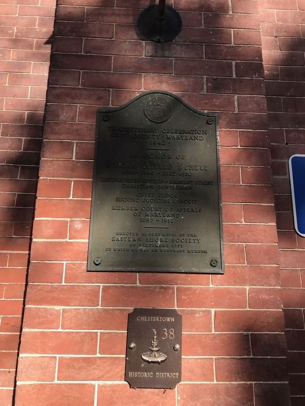
In Honor of
James Alfred Pearce
Born 1840 -- Died 1920
Distinguished Citizen - Eminent Jurist
Christian Gentleman
Chief Judge of Second Judicial Circuit
Member Court of Appeals of Maryland 1897 - 1912
Erected August 1, . . . — — Map (db m62849) HM
In 1715 Edward Crew leased Fish Hall (Fishall Pattent 1664) for 11 years at the yearly rate of one ear of corn. Crew purchased 60 of the original 225 acres for 3000 lbs. of tobacco in 1726 and the remaining 165 acres in 1728. Fish Hall later became . . . — — Map (db m167078) HM
Master Machinist and Blacksmith, he was the third generation of his family to devote his life to work with forge, torch and anvil on this site. The Wagner Blacksmith and Machinery Repair Shop began serving the residents of Kent County in the 1850s. . . . — — Map (db m3071) HM
From 1880 to 1962, musicians entertained summer visitors from the bandstand at Tolchester Beach, a resort and amusement park in Kent County, Maryland, constructed to attract day trippers traveling by steamboat from Baltimore and Washington, D.C. . . . — — Map (db m285782) HM
Nearby, William Claiborne (1600-1677) built a warehouse about 1631 to support his trading post on Kent Island in Chesapeake Bay. When Maryland seized the island in 1632, Claiborne fought an unsuccessful "naval war." Born in Kent County, England, he . . . — — Map (db m33832) HM
The house before you - known as Knock's Folly - has witnessed more than 200 years of history. Henry Knock constructed the original clapboard log portion of the house around 1753. Donaldson Yeates bought the log house in 1770. After his death, his . . . — — Map (db m64354) HM
Worton Point 'Colored' Public School #2, District Number 3; a one-room schoolhouse built August 1890. This structure was documented by the University of Delaware Center for Historic and Architectural Design in June 2003. Prior to the 1930's . . . — — Map (db m62847) HM
The Price of Prosperity
By the latter part of the 17th century, the development of the plantation economy of Maryland was well established. The shift of political power from English nobles to wealthy planters and fewer indentured servants . . . — — Map (db m146563) HM
This part of what is now Kent County, Delaware was one of the state's earliest sites of English colonization. Beginning in the 1660's plantations were established along the St. Jones River. The Dickinson family of Talbot County, Maryland was among . . . — — Map (db m245466) HM
Near this site stood the home of Judge Thomas White, member of the Colonial Maryland legislature and Delaware House of Assembly, Chief Justice of the Kent County Court of Common Pleas, and delegate to the Delaware Constitutional Conventions of 1776 . . . — — Map (db m142642) HM
Kent House, the oldest known standing structure in Rapides Parish, was built by Pierre Baillio, completed in 1800. Baillio constructed the house on land received through a Spanish land grant circa 1794. — — Map (db m38288) HM
Commander Penna Troops. Served at Princeton, Brandywine, Germantown and Monmouth. Incensed at the cabal against Washington he wounded Gen. Conway in a duel. Lived nearby and served in General Assembly of Maryland from Kent County. Buried in . . . — — Map (db m129181) HM
Founded in the 1670s, New Yarmouth was one of the first towns established in Maryland. Located along Gray's Inn Creek, on land owned by Thomas Ringgold, was the site of Kent County's first courthouse. In 1683, New Yarmouth was designated the sole . . . — — Map (db m302849) HM
The origin of this congregation can be traced to the days of the American Revolution, when Methodist pioneers such as Francis Asbury and Freeborn Garrettson
traveled throughout this area organizing groups or “societies” for worship. Many of the . . . — — Map (db m60461) HM
Byway Destinations
Few places portray the intimate connections between land and water better than Maryland's Eastern Shore.
Each place has different stories to tell—present in the wetlands, wharves, fields, homes, . . . — — Map (db m189392) HM
Home of
Thomas Smyth, Sr. 1730-1819
Member of the
Maryland Council of Safety 1775-1776,
Commissary of Troops Kent County 1777.
His shipyard built the Maryland Navy
Galley "Chester", launched 1777. — — Map (db m138238) HM
The population center of the United State was in present West Virginia four times as it moved westward across the nation: near Wardensville in 1820; at Smoke Hole in 1830; west of Buckhannon in 1840; near Burning Springs in 1850. — — Map (db m23212) HM
The population center of the United States was in present West Virginia four times as it moved westward across the nation: near Wardensville in 1820; at Smoke Hole in 1830; west of Buckhannon in 1840; near Burning Springs in 1850. — — Map (db m14416) HM
Few places portray the intimate connections between land and water better than Maryland’s Eastern Shore. Each place has different stories to tell—present in the wetlands, wharves, fields, homes, shops and churches.
Stevensville Lovers of . . . — — Map (db m80838) HM
You are looking at a rare survivor—a building that embodies the radical social change brought on by the Civil War. In 1882, 28 African American veterans of the United States Colored Troops (USCT) chartered the Charles Sumner Post #25, Grand Army . . . — — Map (db m199235) HM
At the outbreak of the Civil War in 1861, George Vickers opposed secession and used his influence to keep Maryland in the Union. He became a major general of the 2nd Division, Maryland Militia, and helped form the 2nd Regiment Eastern Shore . . . — — Map (db m156850) HM
In Memory of more than 400 prominent United States Colored Troops from Kent County, Maryland who bravely displayed extraordinary acts of heroism as they faithfully served their country with courage & honor in an attempt to gain freedom & equality . . . — — Map (db m5414) WM
Water. The Chesapeake Bay and its tributaries weave the tapestry that is Chesapeake Country.
Land. Agriculture and pristine natural resources areas accentuate our rural character.
History. Historic buildings, churches and . . . — — Map (db m199219) HM
Few places portray the intimate connections between land and water better than Maryland's Eastern Shore.
Each place has different stories to tell—present in the wetlands, wharves, fields, homes, shops and churches.
Stevensville . . . — — Map (db m199221) HM
Water The Chesapeake Bay and its tributaries weave the tapestry that is Chesapeake Country.
Land Agriculture and pristine natural resource areas accentuate our rural character.
History Historic buildings, churches, and landscapes are . . . — — Map (db m80828) HM
From 1880 until 1962, musicians entertained summer visitors from this bandstand at Tolchester Beach, a resort town and amusement park in Kent County, Maryland. Constructed to attract daytrippers traveling by steamboat from Baltimore and . . . — — Map (db m158583) HM
Kent County braced for the return of the British in August 1814. Enemy raiders had destroyed nearby Georgetown the previous year while terrorizing Maryland's Eastern Shore. Now they were back in an attempt to divert attention from their main . . . — — Map (db m186648) HM
John Parke Custis was the adopted stepson of George Washington and had been raised at the nearby Washington estate of Mount Vernon. He and his wife, Eleanor Calvert, lived in New Kent County with their first two daughters. However, Custis wanted to . . . — — Map (db m298471) HM
Tallulah Bankhead 1902 - 1968. Alabama's Best-Known Actress.
Tallulah Bankhead was the toast of the London theatre in the 1920's, and nationally renowned for her dramatic roles in “The Little Foxes” (1939), “The Skin of Our . . . — — Map (db m27850) HM
What is a Hundred?
A hundred is an old English subdivision of a county. Although the origin is somewhat shrouded in mystery [,] basically it was a tract of land large enough to provide a hundred men to serve in the king’s wars. In American . . . — — Map (db m156916) HM
African American Civil War veterans constructed this meeting hall for Charles Sumner Post No. 25, Grand Army of the Republic (G.A.R.) in 1908. The hall is one of only two known to survive that were built for soldiers who served in . . . — — Map (db m156672) HM
“Swish”
Philadelphia A.L., 1936
Chicago N.L., 1939–1948
Philadelphia N.L., 1948–1953
Born Chestertown, Kent County, Eastern Shore of Maryland, 1914. Graduate of Washington College 1936. Feared and respected . . . — — Map (db m3058) HM
Erected by act of Assembly of Maryland, May 1736, on a tract called Tolchester. A base of Continental supplies, 1775 to 1783. Port of Entry and ferry landing. George Washington stopped here enroute to points north and south.
Burned by British . . . — — Map (db m155498) HM
1840 - 1963
Site of
Liberty Street Presbyterian Church
(African)
1st Pastor, Henry H. Garnet,
1840-48; Local, State and
Nat'l Abolitionist Meetings:
Draft Riot Site, 1863
Beta Psi Boulé, Sigma . . . — — Map (db m93298) HM
Erected to honor the heroism of the men who so bravely defended Fort Duffy and Fredericktown against the British Fleet May 5, 1813 Colonel Thomas Ward Veazey, commanding
Samuel Wroth; D.F. Heath; Moses Cannon; Nicholas Franks; John W. . . . — — Map (db m155571) WM
Here stood
The Kent County Free School
authorized and established
by act of
Council and Assembly of Maryland
September 26, 1723
This became Washington College
October 15, 1782 — — Map (db m274231) HM
Welcome to Kent County! The Civil War intruded into quiet Eastern Shore communities, and residents of this beautiful, water-laced region faced difficult choices.
In the years before the war, enslaved African Americans from the Eastern Shore . . . — — Map (db m190079) HM
Early September 3, 1814, at Mitchell House, British raiders roused Joseph T. Mitchell and his wife from their bed, shot their horses, and abducted Mitchell. They believed he ws commissary general for all of Maryland.
His was a lesser job as . . . — — Map (db m80628) HM
Welcome to Kent County! The Civil War intruded into quiet Eastern Shore communities, and residents of this beautiful, water-laced region faced difficult choices.
In the years before the war, enslaved African Americans from the Eastern Shore . . . — — Map (db m204955) HM
Historic Roads of Newark, Delaware
1. Old Baltimore Pike
The Old Baltimore Pike was built before 1720 and connected Elkton, Maryland to Christiana. It followed the path of an east-west Indian trail over the south side of Iron Hill. . . . — — Map (db m214020) HM
The first memorial service in Illinois, and one of the first in the nation, to honor those who had died in the Civil War, took place at Woodlawn Cemetery on April 29, 1866. On that day, a group of more than 200 veterans gathered at the old "Blue . . . — — Map (db m163493) HM
Stanley Vansant built boats and worked the waters of Kent County, Maryland. From his boatyard in Long Cove, off the lower Chester River's Piney Neck, he constructed hundreds of bateau and deadrises. Their rugged quality and beauty made for local . . . — — Map (db m273592) HM
(side 1)
The Colonial River Road
After centuries of use by native people and the colonists of New Kent County, the road along the Pamunkey River was extended past the tobacco ports of Newcastle and Page’s Warehouse (later . . . — — Map (db m53801) HM
Thin black lines indicate changes in relevance. Between each pair of lines entries are ordered geographically but all have the same relevance.
* Inflectional forms of words are their plurals, singulars, and possessives as well as gramatical tenses and similar variations.