On West Main Street (New York State Route 404) at Pierce Street, on the right when traveling west on West Main Street.
Early Church - 1845 First Universalist Society 1845 - John Farr - mason contractor 1925 - Johnson Brothers Garage 1962 - automotive supply store — — Map (db m113462) HM
On Central Park West at West 77th Street, on the right when traveling south on Central Park West.
With a variety of large buildings on Central Park West, from the ornately festooned limestone Kenilworth Apartments (1908) to the Neo-Gothic Universalist Church (1898) to the Neo-Classical New-York Historical Society (1908-1938), this district . . . — — Map (db m226325) HM
On West Seneca Street (New York State Route 5) at North Sconondoa Street, on the right when traveling west on West Seneca Street.
Mission Church of Oneida Indians, built 1818 at Oneida Castle by Rev. Eleazar Williams. Moved here in 1842 by Unitarians. Became Vernon Town Hall 1892. — — Map (db m150518) HM
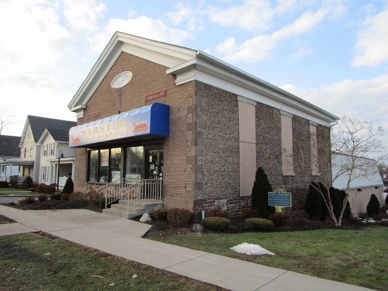
On Howlett Hill Road, 0.1 miles east of NE Townline Road, on the left when traveling east.
Built 1821- has been home
to many faiths- Baptist,
Universalist, Episcopalian,
and since 1943, Presbyterian.
A true community church. — — Map (db m175930) HM
On East Jefferson Street at East Onondaga Street, on the left when traveling east on East Jefferson Street.
The Underground Railroad: What Was It? Traveling by foot, wagon, boat, or railroad, between 100,000 and 150,000 African Americans sought freedom in Mexico, Canada, the Caribbean or the northern U.S. before the end of U.S. slavery in 1865. . . . — — Map (db m138801) HM
On James Street (New York State Route 290) 0.1 miles east of Highland Street, on the right when traveling east.
” …take into consideration the Principles of the American Government, and the extent to which they are trampled under foot by the Fugitive Slave Law.” —a call for a mass convention, signed by George Barnes, 1851
George and Rebecca . . . — — Map (db m138791) HM
On Ridge Road West (New York State Route 104) at Oak Orchard Road (New York State Route 98), on the right when traveling west on Ridge Road West.
Ingenious use of local materials gave rise to a home-grown Seaway Trail architectural style. Cobblestone construction was perfected by local masons between the opening of the Erie Canal and the Civil War. Local farmers had access to the . . . — — Map (db m78221) HM
Placed by the Rockland County Society to mark the oldest building dedicated to God’s service now standing in the County of Rockland, New York ----- this ----- “Old Stone Church” was erected in the year 1813 by a newly organized Society of the . . . — — Map (db m44304) HM
On Lake Logan Road (State Road 215) at Friendly House Road (State Road 1128) on Lake Logan Road.
Founded 1868. Oldest
Universalist church in
western N.C. Hannah J.
Powell led mission work
and school, 1921-42, at
site 100 yards south. — — Map (db m229442) HM
On Reily Millville Rd (County Route 29), on the left when traveling west.
Bunker Hill The Millville, Reilly and Milton Turnpike brought prosperity to the
village now renamed Bunker Hill. School House No. 10 stood nearby
from 1849-1857. By 1860 clothing manufacturing was the major
business here. A Post Office was . . . — — Map (db m107801) HM
On Reily-Millville Road (County Route 29) 0.2 miles west of Bunker Hill Woods Road, on the right when traveling east.
(side A)
Bunker Hill Universalist Church
The Bunker Hill Society was organized about 1845 and fellowshipped in 1854. A frame meeting house, capable of seating 300, was dedicated in 1855. Thirty people united with the church . . . — — Map (db m107789) HM
On Urbana- Woodstock Pike (County Route 2) at Burnwell Street, on the right when traveling west on Urbana- Woodstock Pike.
Rev. George Messenger and his congregation built
the first Universalist Church on this site. It was
dedicated during a state convention of Universalists
in Woodstock in June 1844. In 1893, Rev. John A.
Carpenter was instrumental in erecting a . . . — — Map (db m85116) HM
On Lorain Road (Ohio Route 10) at Columbia Road (Ohio Route 252), on the right when traveling west on Lorain Road. Reported missing.
In 1823, Asher and Abigail Coe migrated from Connecticut and settled here. By mid-century the Coe family operated the second largest dairy farm in Ohio. Their home was used as a post office in 1843. The Universalist Church, built in 1847 at . . . — — Map (db m202520) HM
On Porter Road north of Lorain Road (Ohio Route 10), on the left when traveling north.
The Universalist religious movement spread across Ohio as the state was settled in the 1800s. Universalists proclaimed a loving God and universal salvation. Believers were sometimes scorned as “no-Hell-ers.” Olmsted’s First Universalist . . . — — Map (db m134225) HM
On Cedar Point Road east of Lewis Road, on the left when traveling west.
From 1829 to 1842, the northern region of Olmsted Township was called Frostville. It was named by Elias C. Frost, who operated a post office in his farmhouse located at what became the intersection of Kennedy Ridge and Columbia Roads in North . . . — — Map (db m136817) HM
On East Morenci Street (Ohio Route 120) just west of Fulton Street, on the left when traveling east.
Congregation gathered 1852
Church Dedicated October 18, 1868
Renovated and rededicated:
December 4, 1904
Erected on land donated by Jinks Morey, Universalist and founder of Morey's Corners, now Lyons, Ohio.
Oldest Royalton Township . . . — — Map (db m175858) HM
On Livermore Street at Center College Street, on the left when traveling south on Livermore Street.
Chartered in 1852 by the Christian Church and later a Unitarian institution, Antioch College opened with educational pioneer Horace Mann as its first president. One of the earliest co-educational colleges in the United States, from its inception . . . — — Map (db m12471) HM
On Court Street at John Street, on the right when traveling west on Court Street.
Gaines High School. In 1866, Gaines High School (grades 7-12), one of the first high schools for African Americans in Ohio, opened just west of this site in the same building as the Western District Elementary School, completed in 1859 and . . . — — Map (db m23956) HM
On North Main Street (Ohio Route 58) just north of West Lorain Street (Ohio Route 511), on the left when traveling north.
First Church was built by the Oberlin Community in 1842-44
for the great evangelist Charles Grandison Finney (1792-1875).
He was its pastor, headed Oberlin College’s Theology Department, and later became College president. In the
mid-19th . . . — — Map (db m144079) HM
On Kennebec Avenue (Ohio Route 276) at Jefferson Avenue, on the left when traveling north on Kennebec Avenue.
This former Universalist Church, which held a strong conviction for education and the pursuit of knowledge, was built in 1852 at a cost of $3,500. In 1865, its members decorated the first Christmas tree to be placed in a church in McConnelsville. . . . — — Map (db m13401) HM
On High Street (Ohio Route 261), on the left when traveling south.
On this site on May 29, 1851, Sojourner Truth, a former slave, gave her world famous "And Ain't I a Woman?" speech, recalling the hardships she had endured. Active in both the Abolitionist and Women's Rights Movements, she electrified an audience . . . — — Map (db m43726) HM
[Side A:]
Born in Massachusetts in 1805, Sala Bosworth spent all but nineteen years of his eighty-five years in Washington County. After studying at the Philadelphia Academy of Fine Arts, he returned to the county to paint many full size . . . — — Map (db m20127) HM
On Memorial Highway at Blacksmith Road on Memorial Highway.
Built 1745 by Dr. George de Benneville, preacher in this area 1743-55, and founder of Universalism in America. He died in Philadelphia in 1793. The house is 2.25 miles away on a side road. — — Map (db m84526) HM
On Sheshequin Road, 0.6 miles north of Bridge Street/Ghent Hill Road, on the right when traveling north.
The first Universalist Society in Bradford County was
organized in Sheshequin in 1808 and became a church organization in 1880.
This building was erected in 1827 by the united efforts of the members
who made "bees" to haul the stone, fell . . . — — Map (db m154019) HM
On South Main Street at Chestnut Street, on the right when traveling north on South Main Street.
A fine example of Greek Revival architecture. It was erected in 1835-36 at a cost of $3500, mostly given by Shippen and Huidekoper families. Planned by the builder of Fort Sumter, General George W. Cullum. — — Map (db m41031) HM
On Front Street at Water Street, in the median on Front Street.
The noted English scientist, discoverer of oxygen, and Unitarian theologian lived in Northumberland 1794 to 1804. His home and laboratory along the river are now a Priestley memorial and museum. — — Map (db m87649) HM
Near Priestley Avenue at Hanover Street, on the right when traveling north.
Joseph Priestley (1733-1804) — Unitarian minister, teacher, author, natural philosopher, discoverer of oxygen, and friend of Benjamin Franklin and Thomas Jefferson — supervised the construction of this house and laboratory from 1794 to 1798, then . . . — — Map (db m176924) HM
On Duke Street (Pennsylvania Route 147) at 10th Street when traveling south on Duke Street.
The noted English scientist, discoverer of oxygen, and Unitarian theologian lived in Northumberland, 1794 to 1804. His home and laboratory along the river are now a Priestley memorial and museum. — — Map (db m120475) HM
On Chestnut Street at South Van Pelt Street, on the left when traveling east on Chestnut Street.
Frank Furness, famed Philadelphia Victorian architect, designed this building. The cornerstone was laid in 1885. It houses distinctive architectural features and notable stained glass. — — Map (db m146383) HM
On North 4th Street just south of Arch Street, on the right when traveling south. Reported missing.
In a building of the University of Pennsylvania which stood near this spot "The First Society of Unitarian Christians in Philadelphia," being the first church in America to adopt the Unitarian name, was organized 12 June 1796, under the influence of . . . — — Map (db m175875) HM
On South Water Street (U.S. 44) at Packet Street, on the right when traveling south on South Water Street.
Providence has changed dramatically since its founding in 1636, from the early settlement enriched by farmland, to the town competing with Newport for trade, to the thriving capital it is today. This evolution can be evaluated through a case . . . — — Map (db m151732) HM
On Washington Street just south of Greene Street, on the right when traveling north.
Established 10 April 1821 at Westminster and Union Streets.
Third Sanctuary dedicated, 20 November 1872.
Founding member, Rhode Island State Council of Churches, 1937.
Organizing member, Providence Intown Churches Association, 1974. . . . — — Map (db m151643) HM
On King Street near Gateway Walk, on the right when traveling south.
Founded 1787.
Avowedly Unitarian
since 1819
—
One of the oldest
Unitarian Churches
in the United States
and
the oldest one in
the South
O — — Map (db m48237) HM
Unitarian Church has been designated a National Historic Landmark. This site possesses national significance in commemorating the history of the United States of America. — — Map (db m48160) HM
On West 12th Street just east of South Dakota Avenue, on the right when traveling east.
Arriving in Sioux Falls, Dakota Territory in 1878, Eliza Tupper Wilkes quickly became one of the community leaders of the small prairie town. She was born Eliza Smith Tupper on October 8, 1844 in Houlton, Maine. As a young woman she . . . — — Map (db m184707) HM
Near Center Street at Cemetery Circle, on the left when traveling north.
Built by the Town of Lyndon in the summer of 1809 as a meeting house for the religious services of four congregations – Baptist, Congregational, Methodist, and Universalist – and for town meetings. The “Town House” was . . . — — Map (db m136690) HM
On Main Street (U.S. 2) at Church Street, on the right when traveling west on Main Street.
Had you stood at this location in the early 1800s, you would have had to lift your skirt off the dirt lane to step up onto the plank sidewalk or guard your hat from the danger of low wooden canopies. Pedestrians competed with horse and carriage on . . . — — Map (db m23579) HM
On Pearl Street at Church Street, on the right when traveling west on Pearl Street.
Designed by noted architect Peter Banner of Boston, the Federal-style Meeting House was built in 1816 for the First Congregational Society (Unitarian) and is the oldest surviving place of worship in Burlington. Banner's design features a projecting . . . — — Map (db m97755) HM
The Round Church This 16-sided church, Richmond's first meeting house, was built by a group led by William Rhodes in 1812-12 on land donated by Issac Gleason & Thomas Whitcomb. The first Proprietors were members of five denominations: Baptist, . . . — — Map (db m76387) HM
On Fort Bridgman Road (Vermont Route 142) west of Greenway Drive, on the right when traveling west.
The first Vernon Union Church was built in 1845 for the Universalist society. Anna Marsh, daughter of Lt. Gov. Jonathan Hunt, bequeathed $2,000 to Vernon, “for the support of preaching” in the town. The church has received this support since 1834 . . . — — Map (db m185954) HM
On Stimpson Hill Road, 0.1 miles south of Vermont Route 100, on the left when traveling south.
The structure, originally of Greek Revival design, was built in 1861 as a Universalist Church. As its membership declined toward the end of the 19th century, the Congregation found it necessary to relinquish ownership to a community association, . . . — — Map (db m75699) HM
Near Arlington Boulevard (U.S. 50) east of South Pershing Drive, on the right when traveling east.
The Unitarian Church of Arlington (UCA), founded in 1948, had its first permanent home sited here. The first section (on the right) opened in 1949 and the second section in 1952, both designed by UCA member Earl B. Bailey, A.I.A.
Active in the . . . — — Map (db m128220) HM
Near Arlington Boulevard (U.S. 50) west of South George Mason Drive, on the right when traveling east.
Unitarian Universalist Church
of Arlington, Virginia
Sanctuary
1962
Entered in 2014 on the
National Register of Historic Places
United States Department of Interior
Register of Historic Places
Commonwealth of Virginia . . . — — Map (db m128219) HM
Near Wise Street, 0.1 miles north of 4th Street, on the left when traveling south.
Cabell Street Methodist Church
William Amos Laughon (minister, 1885-1889)
Centenary United Methodist Church
(Third Street Methodist Church
Robert F. Hening (trustee, steward, leader of singing, 1840s-80s) • . . . — — Map (db m179829) HM
Near East Franklin Street near North 15th Street. Reported permanently removed.
The grass and wood chips to your right mark the area of an archeological examination of the remnants of one of our nations most notorious slave jails: the Devil’s Half Acre ---- the place where run-away slaves were punished and large numbers . . . — — Map (db m40679) HM
On King Street (County Road 607) just west of Rowser Road, on the left when traveling west.
In the spring of 1862, a passing Union soldier was shot and wounded, allegedly by someone at this house. His enraged comrades broke down the door to ransack and burn the place, but one who had known Moncure Conway earlier recognized his portrait. . . . — — Map (db m148080) HM
On University Bay Drive, 0.2 miles north of University Avenue, on the left when traveling north.
Unitarian Meeting House has been designated a National Historic LandmarkDesigned by renowned architect Frank Lloyd Wright for the First Unitarian Society of Madison, the meeting house is an innovative building that has influenced religious . . . — — Map (db m32413) HM
On East Gorham Street at North Butler Street, on the right when traveling west on East Gorham Street.
Gates of Heaven was designed for Madison's first Jewish congregation by local architect August Kutzbock in the German Romanesque style. Kutzbock also used this distinctive style for the Pierce and Keenan houses at Pinckney and Gilman. The building . . . — — Map (db m32381) HM
On South Page Street at West Jefferson Street, on the right when traveling south on South Page Street.
Stoughton was founded by Luke Stoughton in 1847. The first settlers were Yankees from New England.
Waves of Norwegians immigrated to the community during the late 19th century to make Stoughton America's Norwegian capital, home of lutefisk and . . . — — Map (db m36256) HM
On East Main Street (State Highway 29) at 2nd Street East, on the left when traveling east on East Main Street.
Erected to the memory of Mabel Tainter, daughter of lumberman Andrew L. Tainter and his wife Bertha, and given to area citizens on July 3, 1890, the Memorial reflects advanced American architectural, social, educational and religious thought of the . . . — — Map (db m9854) HM
On County Road T, 0.2 miles east of State Highway 23, on the right when traveling east.
Unity Chapel
Dedicated 1886
has been placed on the
National Register
of Historic Places
by the United States
Department of the Interior
————————
In 1844, Richard and Mallie . . . — — Map (db m90106) HM
On North Astor Street at East Ogden Avenue, on the right when traveling north on North Astor Street.
Erected in 1892 and designated in 1967 as a landmark of the City of Milwaukee by the Milwaukee Landmarks Commission in recognition of its architectural and historical significance to the community. — — Map (db m42573) HM
On Skyline Drive south of Mbokonavera Road, on the left when traveling west.
Welcome to the Guadalcanal American Memorial This monument is a tribute to those Americans and their Allies who participated in the Guadalcanal Campaign from 7 August 1942 to 9 February 1943. It especially honors those soldiers, sailors, . . . — — Map (db m213032) HM WM
ESSEX STREET
was laid out in the grounds by
NICHOLAS BARBON in 1675
Among many famous lawyers
who lived here were
Sir ORLANDO BRIDGEMAN c.1606-1674
Lord Keeper,
HENRY FIELDING 1707-1754
Novelist and
BRASS CROSBY . . . — — Map (db m114240) HM
On Donegall Square East just south of Donegall Square North (Northern Ireland Route A1), on the right when traveling south.
Titanic Memorial Garden is a permanent tribute to over 1,500 passengers and crew who died after the ship struck an iceberg and sank in the North Atlantic during its maiden voyage in April 1912.
When RMS Titanic departed Southampton on 10 . . . — — Map (db m134337) HM
164 entries matched your criteria. Entries 101 through 164 are listed above. ⊲ Previous 100