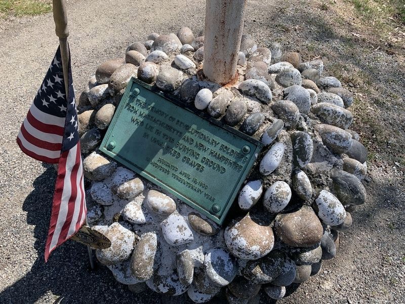
To the memory of revolutionary soldiers from Massachusetts and New Hampshire who lie in this burying ground in unmarked graves. Dedicated April 19, 1930 In Medford's Tercentenary year. — — Map (db m245270) HM WM
Mansion built by Isaac Royall who came here from Antigua with his slaves in 1737. His son Isaac Royall, a loyalist, founded at Harvard the oldest law professorship in the United States. Headquarters of General John Stark during the Siege of Boston. — — Map (db m50420) HM
The original portion of the Royall House appears to have been a farmhouse constructed in 1637 by Governor Winthrop as part of his "Ten Hills Farm." New Hampshire Lt. Governor John Usher enlarged the house and lived in it from 1692 until 1726. . . . — — Map (db m245594) HM
In Commemoration of
Captain Isaac Hall
1739 - 1789
Commander Medford Minute Men
Lexington - Concord alarm
April 19, 1775
A businessman and resident of Medford.
Presented on January 24, 1977
Medford Company of Minutemen . . . — — Map (db m245266) HM WM
This property, which is listed in the State and National Register of Historic Places, has received a matching grant from the Massachusetts Preservation Projects Fund through the Massachusetts Historical Commission, Secretary of the Commonwealth . . . — — Map (db m245265) HM
It is believed that four trees, two ash and two sycamore, were set out in 1780 by Joseph Dowse at the end of the Revolutionary War. Several generations later, one ash and one sycamore, were blown down in the hurricane of 1938. Charles Arthur Dowse . . . — — Map (db m219198) HM
Built before 1747 and kept from 1758 to 1790 by Obadiah Sawtell, "the old landlord." He was a delegate to the Provincial Congress. Here the men gathered at the alarm on April 19, 1775. — — Map (db m48815) HM
This stone windmill built by John Mallet about 1703 was sold to the Province for a gun powder magazine in 1747. Rifled by General Gage of the Colony's powder on I September 1774, it became a magazine of the American Army in 1775-76. — — Map (db m48827) HM
Gen. Putnam set up the French Redoubt after retreating from Bunker Hill. Along with others, the French Redoubt successfully held out against British advances and became a strategic fortification extended from what is not the back of the high . . . — — Map (db m243057) HM
"Ploughed Hill"
Fortified and bombarded in 1775-76
Site of Ursuline Convent
Founded 1820 and opened 1826
Burned 1834. Hill dug down 1875 to 1897
Erected by Mt. Benedict Council No. 75 — — Map (db m243062) HM
Through this place passed General Henry Knox in the winter of 1775 – 1776 to deliver to General George Washington at Cambridge the train of artillery from Fort Ticonderoga used to force the British Army to evacuate Boston. Erected by the . . . — — Map (db m18119) HM
In grateful remembrance of Waltham men and men who served for Waltham in the Revolutionary War.
( 293 names are listed )
Sponsored by the Dorothy Brewer Chapter, Daughters of the American Revolution. Erected A.D. 1940 by the City of . . . — — Map (db m179187) WM
Through this place passed General Henry Knox in the winter of 1775 – 1776 to deliver to General George Washington at Cambridge the train of artillery from Fort Ticonderoga used to force the British Army to evacuate Boston. Erected by the . . . — — Map (db m18116) HM
Here
stood the Meeting House
in which met
The Provincial Congress
from April 22 to July 19, 1775.
Here
the Great and General Court
or Assembly
was Organized and held its
Sessions from July 19, 1775
to Nov. 9, 1776
and from June . . . — — Map (db m244498) HM
Through this place passed General Henry Knox in the winter of 1775 – 1776 to deliver to General George Washington at Cambridge the train of artillery from Fort Ticonderoga used to force the British Army to evacuate Boston. Erected by the . . . — — Map (db m18124) HM
A Tribute to
Colonel John Robinson
1738 - 1805
Westford Citizen and Patriot
In 1775 he distinguished himself by commanding the corps of soldiers who first opposed the menacing attempts of the British troops at Concord Bridge. April 19 1775 . . . — — Map (db m220728) HM
This Memorial Battle Drum is dedicated to those Minutemen and Militia of Middlesex County who opposed the British Regulars on the historic site at the North Bridge in Concord Massachusetts April 19, 1775. Maj John Buttrick of Concord, Lt. Col. . . . — — Map (db m230365) WM
The Town of Westford dedicates this memorial to the men and women who served their country from the Pioneers down through the World War.
Love of freedom linked the generations.
"Liberty and Union now and forever one and . . . — — Map (db m232786) WM
Through this place passed General Henry Knox in the winter of 1775 – 1776 to deliver to General George Washington at Cambridge the train of artillery from Fort Ticonderoga used to force the British Army to evacuate Boston. Erected by the . . . — — Map (db m18120) HM
Thomas Turner a son of Nantucket served on the ship Bon Homme Richard
killed in action with H.M.S. Serapis September 23, 1779
This tablet is placed by the
Society of the Sons of the Revolution
In The Commonwealth of . . . — — Map (db m185019) HM
Is built upon portions of the estate of Ebenezer Warren, who answered the call in the battle Lexington April 19, 1775. He served in the American revolution with two brothers, general Joseph Warren, later killed at the battle of Bunker Hill, and . . . — — Map (db m55871) HM
“Improve your understanding for acquiring useful knowledge and virtue, such as will render you an ornament to society, an Honour to your Country, and a Blessing to Your parents.” Abigail Adams in a letter to her 10-year-old son, John . . . — — Map (db m18502) HM
From this spot, with her son, John Quincy Adams, then a boy of seven, by her side, Abigail Adams watched the smoke of burning Charlestown, while listening to the guns of Bunker Hill. Saturday, 17 June, 1775. < Lower Marker : > The Adams . . . — — Map (db m191821) HM
Farmer Lawyer Patriot Diplomat First Vice President Second President of the United States Side of Monument: There is danger from all men. The only maxim of a free government ought to be to trust no man living with power to endanger the public . . . — — Map (db m18052) HM
On this site was born
John Hancock
January 23, 1737
Son of Reverend John Hancock,
pastor of what is now the
First Parish Church, Quincy
On his father's death, he was
adopted by his uncle — Boston's
wealthiest . . . — — Map (db m118703) HM
On this spot
stood the dwelling
wherein was born
John Hancock
President of the Congress
of the United States
XII January MDCCXXXVII — — Map (db m119009) HM
Site of Quincy’s Liberty Tree used as a rallying place for patriotic societies prior to the American Revolution. Granite Manufacturers Association 1956 — — Map (db m107410) HM
In Grateful Remembrance of The Men of Quincy, Mass. formerly called Braintree who on land and sea fought to establish the independence of the United States of America in The Revolution of 1775-1783 Ebenezer Adams • Daniel Arnold • Hezekiah Bass • . . . — — Map (db m31244) HM
This marks the site of
the home of Amos Mills
the only citizen of this
community to make the
supreme sacrifice for his
country at the battle of
Lexington and Concord. — — Map (db m239313) WM
Built about 1698 by Jacob Leonard sold to Rev. Allen, Minister of the First Parish Church, who under pressure for his Tory sympathies, sold the property to Col. Josiah Edson, a Tory who occupied it until 1775, when it was confiscated by The . . . — — Map (db m209695) HM
Parish members mustered here on the alarm of 19th April 1775.
The last enlistment was 1781 when 13 men were fitted from the sale of pew-places in the church. — — Map (db m209328) WM
This Tablet was Placed by
The Town of Halifax
In Memory of Our
Patriot Soldiers of the Revolution
Joseph Bosworth · Richard Bosworth · Eli Bosworth · Benjamin Bosworth · Andrew Bearce Killed · Samuel Brown · Samuel Briggs · . . . — — Map (db m209135) WM
Dedicated July 14th by the Republic of France and the people of Hull in celebration of the United States of America bicentennial. In grateful tribute to the French sailors and marines who served and died at Fort Independence during the American . . . — — Map (db m56068) HM
In the year 1776.
The Brig Independence
Set sail from Kingston's
Jones River to protect the ships
and coastline of
Massachusetts. — — Map (db m85499) HM
Site of the home of
Nathan Cushing
Judge of Admiralty in the Revolution
Judge of Supreme Court of Massachusetts 1789–1810
State Councilor 1779–1780 1802–1807
Dec 13, 1780 the council ordered that Nathan Cushing Esq
be . . . — — Map (db m50357) HM
Alexander Scammell
1747 -- 1781
Teacher Soldier Patriot
He taught the public school on this site
Colonel and Adjutant General in the
Continental Army
mortally wounded at Yorktown
This memorial dedicated by the
General . . . — — Map (db m73209) HM WM
In 1776 an earthwork fort was erected at the gurnet for the protection of Plymouth Harbor. It mounted six cannons and was manned by militiamen from Plymouth, Kingston, Duxbury and nearby towns. The first lighthouse, built in 1768, stood alongside . . . — — Map (db m107428) HM
In Honor of
Deborah Sampson
Who For Love of Country Served
Two Years as a Soldier in the
War of the Revolution
She was born in Plympton Massachusetts
December 17 1760
This Memorial erected by the
Deborah Sampson Chapter
Daughters . . . — — Map (db m209129) HM WM
John Glover, of Marblehead, a soldier of the Revolution.
He commanded a regiment of one thousand men raised in that town, known as the Marine Regiment and enlisted to serve through the war; he joined the camp at Cambridge June 22, 1775, and . . . — — Map (db m176355) HM WM
Stamp Act passed 17 repealed 1766
Board of customs established 1767
British troops fired on the inhabitants of Boston March 5, 1770
Tea Act Passed 1773
Tea defrayed in Boston December 16
Port of Boston shut and guarded June 1, 1774 . . . — — Map (db m215099) HM WM
Crispus Attucks • Samuel Maverick • James Caldwell • Samuel Gray • Patrick Carr
From that moment we may date the severance of the British Empire.
Daniel Webster
On that night the foundation of American Independence was . . . — — Map (db m215093) HM WM
Born in Wexford Ireland 1745 Died in Philadelphia 1803 Received first commission from the Continental Congress to command the Lexington 1775 Sailed from Boston on the Raleigh 1778 Acclaimed in Boston in 1780 for victories on the Alliance Appointed . . . — — Map (db m41561) HM
Champion of liberty and the rights of man.
Erected by the Polish People
of New England to commemorate
the 150th anniversary of his arrival
in America to enlist in the cause
of liberty — — Map (db m117910) WM
The Common an Historic Overview In 1634, only four years after John Winthrop and the Puritans of the Massachusetts Bay Colony settled the Shawmut Peninsula and created the town of Boston, these colonists bought a 48-acre tract of land on the . . . — — Map (db m191834) HM
This mall is named in honor of Marquis de Lafayette
distinguished French soldier
Major-General in the War of American Independence
and illustrious patriot of the French Revolution
who nobly served the cause of liberty on two . . . — — Map (db m73212) HM
--------------- Site of the Battle of Bunker Hill fought June 17, 1775 --------------- Although orders were issued by the Committee of Safety to seize and fortify Bunker Hill the colonial officers after consultation fortified this hill on June 16, . . . — — Map (db m17974) HM
Established in 1810, this is Charlestown's second oldest burying ground, and the site of the left wing of Colonial forces at the Battle of Bunker Hill in 1775. A monument marks the location of the Rail Fence and Stone Wall fortified by the . . . — — Map (db m55532) HM
“Don’t fire ‘til you see the whites of their eyes.” The Battle of Bunker Hill, fought here on Breed’s Hill, June 17, 1775, was the first major military confrontation of the Revolutionary War. Although the British won the . . . — — Map (db m18094) HM
Training fields were a familiar sight in early New England in an era of constant alert.
American colonist formed militias for protection and trained in open fields also known as commons. Charlestown Training Field dates from the 1640s . . . — — Map (db m115250) HM
June 17, 1775 He who brought us over still sustains us. Connecticut American Revolution Bicentennial Commission South Marker:
General Israel Putnam of Connecticut helped decide to fortify the Charlestown peninsula and with Captain Thomas . . . — — Map (db m191806) HM
This 1790s Georgian residence was built for Deacon John Larkin, a patriot best remembered for his role in Paul Revere's legendary midnight ride. It was Larkin's horse that carried Revere out to Lexington and Concord to warn the Committee of Safety . . . — — Map (db m60235) HM
Colonel William Prescott of Massachusetts led the colonial forces on Breed’s Hill. His commanding figure and strong will inspired the farmer soldiers to the greatness of the day. Dr. Joseph Warren, commissioned a Major General, elected to serve . . . — — Map (db m18651) HM
June 17, 1775 Strength United is Stronger New Hampshire American Revolution Bicentennial Commission East Marker: Colonel John Stark commanded 900 New Hampshire men at the rail fence and at the stone wall on the Mystic River shore against the . . . — — Map (db m115949) HM
At this site Paul Revere landed on the night of April 18, 1775 to begin his midnight ride Dedicated by The Massachusetts Society Sons of the American Revolution April 1999 — — Map (db m17971) HM
On the night of April 18, 1775, Paul Revere set out to warn of the march of British troops on Lexington and Concord. He departed Boston by water, was rowed to Charlestown, and landed near here. Walking the short distance into town, Revere borrowed a . . . — — Map (db m191888) HM
This high ground of Breed's Hill bound the American colonies to the cause of independence. An open field once located here commanded this entire area. On the night of June 16, 1775, two month after the fighting at Lexington and Concord, 1,200 . . . — — Map (db m60140) HM
Neighborhood of Revolution “Paul Revere . . . started on a ride which, in a way has never ended.” - Esther Forbes, author of the classic study, Paul Revere and the World He Lived In In the course of just two pivotal days – April 18 and . . . — — Map (db m191830) HM
The Leonard P. Zakim
Bunker Hill Bridge
The Leonard P. Zakim Bunker Hill Bridge, part of The Big Dig Project in Boston, is the widest cable-stayed bridge in the world. The Bridge serves as the northern entrance to and exit from Boston. The . . . — — Map (db m58257) HM
The line of Rail Fence and Grass Protection formed after the British Troops landed on the seventeenth of June extended in this direction to Mystic River — — Map (db m55530) HM
The rail fence and grass line of protection formed after the British troops landed was six hundred feet in the rear at the base of Bunker Hill — — Map (db m18659) HM
In the years following the battle, this hill became sacred ground. A new patriotic spirit swept the nation in the 1820s. Americans looked to honor the sacrifice and service of their ancestors. For two decades, many men and women, led by the Bunker . . . — — Map (db m60139) HM
Three Centuries of Use & Transformation
First noted in the 1640s as a “well-established public place.”
Training fields were an integral part of early New England
landscapes. On annual “Muster Days,” the local militia met
here for . . . — — Map (db m176943) HM
On this hill the Continental militia fought heroically on June 17, 1775. Protected by an earth and timber redoubt laid out by Colonel Richard Gridley, the Army’s first chief engineer, the Americans killed or wounded nearly half of the attacking . . . — — Map (db m18653) HM
The British Army was one of the most powerful military forces of the day. Their leaders were career officers. The troops were regularly trained and well equipped. Yet, the enlisted ranks were often filled with soldiers recruited against their will . . . — — Map (db m60143) HM
Constructed in 1850 for Boston businessman
David Sears, the Liberty Tree Block's transitional style weds Greek Revival architecture with Italianate style details. A ballroom with lavish drawing rooms was once located above street level shops. . . . — — Map (db m176252) HM
Boston Massacre 1770
Many Bostonians resented the presence and abuses of such a large military force in their midst, hostility grew rapidly, and there were frequent brawls between workers and soldiers. On the night of March 5, 1770, Captain . . . — — Map (db m215503) HM
The Boston Tea Party was the result of a series of events that steadily aroused the ire of colonists who considered themselves British subjects and should have the same rights and privileges as any subjects that lived in England . . . — — Map (db m215505) HM
The meeting in which you are about to participate is a dramatization of the protest meetings held at Old South Meeting House in November and December, 1773. The largest building in colonial Boston and a popular gathering place for dissent and . . . — — Map (db m234471) HM
The meeting in which you are about to participate is a dramatization of the protest meetings held at Old South Meeting House in November and December, 1773. The largest building in colonial Boston and a popular gathering place for dissent and . . . — — Map (db m234472) HM
Realizing that the Sugar Act could not generate enough revenue, Parliament passed the Stamp Act of 1765, directly taxing the colonial citizens. . . . — — Map (db m215500) HM
From 1769-1776 Boston was the flashpoint for events leading up to the American Revolution. On February 22, 1770, a crowd gathered around the house and shop of a Tory sympathizer and customs agent, Ebenezer Richardson. When they started pelting the . . . — — Map (db m18766) HM
Front of Monument: Born in Boston, 17 January, 1706. Died in Philadelphia, 17 April, 1790. Right Side of Monument: Treaty of Peace and Independence 3 September, 1783 Rear of Monument: Eripuit Colo Tulmen Sceptrumque Tyrannis. Left . . . — — Map (db m18506) HM
Friend–
Look up and see the North Church Tower where were shown two lantern lights on the night of April 18, 1775, to send Paul Revere on his famous ride and begin the American Revolution. This view preserved for all future generations by . . . — — Map (db m186290) HM
has been designated a Registered National Historic Landmark Under the provisions of the Historic Sites Act of August 21, 1935 this site possesses exceptional value in commemorating or illustrating the history of the United States U.S. Department . . . — — Map (db m18087) HM
This building was built in 1729 as a Puritan meeting house. Benjamin Franklin was baptized here. Phillis Wheatley, the first African American author, worshipped here.
In the years leading up to the American Revolution, colonists gathered . . . — — Map (db m176110) HM
In Memory of The Chevalier de Saint Sauveur
first Chamberlain of his Royal Highness, Count d'Artois, brother of his Majesty
the King of France
“Cet officier, aide-major de l'escadre française et lieutenant de vaisseau . . . — — Map (db m176938) HM WM