“Uncle Sam” The birthplace of Samuel Wilson once stood near the main crossroad of the Northwest parish of Cambridge, the center of the district known as Menotomy. Wilson, born on September 13, 1766, was only eight when . . . — — Map (db m45243) HM
To the memory of Gen. Casimir Pulaski, Polish Patriot who fought for freedom on two continents. He volunteered his services to the Continental Army of the U. S. For distinguished service at the Battle of Brandywine, he was appointed a Brigadier . . . — — Map (db m18166) HM
To the memory of Gen. Thaddeus Kosciuszko, Polish Patriot • Hero of two continents • Champion of Liberty and the rights of man • He came to America in 1776 and volunteered his services for the cause of American Revolution • His valor and genius . . . — — Map (db m18167) HM
Built by the Province of The Massachusetts Bay in New England, in 1763
Named in honor of Thomas Hollis of London, Merchant, and other members of the same family, constant and generous benefactors of Harvard College from 1719 to 1804
. . . — — Map (db m109037) HM
Past this place at midnight, April 18-19, 1775, rode at the gallop William Dawes, member of the Ancient & Honorable Artillery Company and first rider to alert the Minutemen that the British were marching on Lexington and Concord. Route of William . . . — — Map (db m177009) HM
These cannon were abandoned at Fort Independence (Castle William) by the British forces when they evacuated the City of Boston March 17, 1776. — — Map (db m18003) HM
Built in 1759 Headquarters for George Washington 1775 – 1776 . Home of Henry Wadsworth Longfellow Family & Descendants 1837 1950 — — Map (db m19085) HM
Washington’s General Orders given at Cambridge, July 4, 1775
“The Continental Congress having taken all the troops of the several Colonies, which have been raised, or which may be hereafter raised for the support and defense of the Liberties . . . — — Map (db m17999) HM
Constructed November 1775 by the Continental Army under General George Washington. This fort was used during the Siege of Boston and helped force its evacuation by the British. — — Map (db m18763) HM
Historic Plaque On this spot stood Jake & Earl's Dixie BBQ
A favorite hangout of local patriots
Destroyed by a regiment of British troops in
the spring of 1775.
Officially not on the Freedom Trail, it was
still one of Paul Revere's . . . — — Map (db m70038) HM
The Pasture
When Cambridge was settled in 1630, the town extended 35 miles into the countryside and all the land outside the village was held in common. The most desirable tracts were distributed to settlers, but some pastures were . . . — — Map (db m215360) HM
At this place General Henry Knox delivered to General George Washington in January 1776 the train of artillery brought from Fort Ticonderoga to force the enemy to evacuate Boston. — — Map (db m17963) HM
Near this spot on July 3, 1775,
George Washington
took command of the American Army
In memory of this event, this gate, was erected A.D. October, 1906 — — Map (db m215363) WM
He represented those who had no voice, position or power. He exemplified those principles on which this nation was founded.
Proclamation of the City of Cambridge, 2008
The five black panels are . . . — — Map (db m215348) HM WM
Christ Church was established in 1759 to serve Cambridge's Anglican community, including students at Harvard College.
Peter Harrison, the preeminent architect of his day, designed this church, King's Chapel in Boston, and Touro Synagogue . . . — — Map (db m215346) HM
Erected by the City A.D. 1876, to the memory of John Hicks, William Marcy, Moses Richardson, buried here. Jason Russel, Jabez Wyman, Jason Winship, buried in vicinity.
Men of Cambridge who fell in defence of liberty of the people April 9, . . . — — Map (db m215344) WM
On this site stood the original meeting house where Minutemen, from what is now Carlisle, assembled and marched to the North Bridge in Concord April 19, 1775
Stg. James Nickles • Pvt. Nathon Munroe •
Pvt. John Nickles • Pvt. Aaron Munroe • . . . — — Map (db m103323) HM WM
South-southeast face:
In honor
of the
Townsmen of Chelmsford
in the
War of the Revolution
This monument is erected
by a
Grateful posterity.
East-northeast face:
Lt. Col. Moses Parker
and
Capt. Benj. Walker
Wounded at . . . — — Map (db m31182) HM
“The world has seen no grander movement than that of our Revolution . . . The people, to a man, were full of a great and noble sentiment. It is marvelous to see how many powerful writers, orators, and soldiers started up just at the . . . — — Map (db m45235) HM
19 April 1775 Near this site was buried a British soldier of the 4th the King’s Own Regt. of Foot fatally wounded at North Bridge — — Map (db m18168) HM
Here on this site lived the Brown family of Concord, who arrived from England in 1644. The exposed foundation on you left is from the first Brown family home. During the 1750s, their descendent David Brown constructed a new house. On your right, the . . . — — Map (db m18204) HM
On the morning of April 19, 1775, approximately 400 colonials stood on the hill overlooking the North Bridge. As smoke rose from Concord center, the order to march was given. In the exchange of fire that followed, Captain Isaac Davis, who had . . . — — Map (db m18024) HM
In 1775 Casey was Samuel Whitney’s slave. When revolution came, he ran away to war, fought for the colonies, and returned to Concord a free man. — — Map (db m18526) HM
Here on the 19th of April 1775 was made the first forcible resistance to British aggression. On the opposite bank stood the American Militia. Here stood the invading Army and on this spot the first of the enemy fell in the War of that Revolution . . . — — Map (db m18021) HM
On the morning of April nineteenth, 1775, while the British held this bridge, the minute-men and militia of Concord and neighboring towns gathered on the hill across the river. There the Concord Adjutant, Joseph Hosmer, demanded, “Will you let . . . — — Map (db m18027) HM
They came three thousand miles and died to keep the past upon its throne. Unheard beyond the ocean tide, their English mother made her moan. April 19, 1775 — — Map (db m18022) HM
On the morning of April 19, 1775, the British march from Boston which resulted in the outbreak of the Revolutionary War ended here with a search for military stores. Gun carriages found by the light infantry were burned in front of the house. Other . . . — — Map (db m18064) HM
At the time of the Battle, this area was a cleared pasture owned by Samuel Brooks, whose house is on Battle Road before you. In contrast to today’s forested landscape, the 1775 landscape was predominantly open farmland. A common myth about the . . . — — Map (db m18554) HM
Here was the home of the Colonial officer who led the advance to the North Bridge. With British soldiers firing directly at his men, Major John Buttrick gave the order, “Fire, fellow soldiers, for God’s sake, fire!” It was the first . . . — — Map (db m18173) HM
Here begins the Battle Road. After brief battles at Lexington Green and Concord’s North Bridge, Colonists and British soldiers clashed here at Meriam’s Corner. Colonial militia and minute men coming from the North Bridge fight were joined by . . . — — Map (db m18057) HM
The British Troops retreating from the Old North Bridge were here attacked in flank by the Men of Concord and neighboring towns and driven under a hot fire to Charlestown. — — Map (db m191805) HM
Minute Man National Historical Park was the starting place of the American Revolution; here the resolve of citizens willing to risk their lives for the ideals of liberty and self-determination was instrumental in the formation of the American . . . — — Map (db m191812) HM
Concord HymnBy the rude bridge that arched the flood, Their flag to April’s breeze unfurled, Here once the embattled farmers stood, And fired the shot heard round the world. The foe long since in silence slept; Alike the conqueror silent . . . — — Map (db m45237) HM
The First Provincial Congress of delegates from the towns of Massachusetts was called by conventions of the people to meet at Concord on the eleventh day of October 1774. The delegates assembled here in the Meeting-House on that day and organized . . . — — Map (db m18524) HM
Used for water, fish, power and skating lay south and west of this spot. April 19, 1775 British troops dumped captured cannon shot, musket balls and barrels of flour into the pond. The militia later recovered most of the ammunition and a good part . . . — — Map (db m18555) HM
“Will you let them burn the town down?” Lt. Joseph Hosmer of Concord “I haven’t a man who’s afraid to go.” Captain Isaac Davis of Acton “Do not fire on the King’s troops unless first fired . . . — — Map (db m18200) HM
Minute Man National Historical Park was the starting place of the American Revolution; here the resolve of citizens willing to risk their lives for the ideals of liberty and self-determination was instrumental in the formation of the American . . . — — Map (db m191819) HM
Minute Man National Historical Park was the starting place of the American Revolution; here the resolve of citizens willing to risk their lives for the ideals of liberty and self-determination was instrumental in the formation of the American . . . — — Map (db m191893) HM
Welcome to
The Old Manse
Incendiary Ideas and Creative Passion
The residents of The Old Manse played a key role in the formation of this nation. They helped spark the revolution that brought American Independence, and for . . . — — Map (db m223833) HM
In 1775 you would be standing at a fork on the Groton Road. The east fork, restored by the National Park Service, today leads up the hill to the Visitor Center. The west fork, now traced as a mown path, led to Colonel Barrett’s farm over a mile . . . — — Map (db m18202) HM
Built in 1747 Kept by Amos Wright in 1775 --------------- Here met the Committees of the Provincial Congress on the eve of the Revolution while the larger body sat in a Meeting House close by. --------------- Headquarters of the Minutemen in the . . . — — Map (db m18525) HM
In 1775, the house before you was the home of Job and Anna Brooks, and their children Asa and Anna. Across the street was the home of cousin Joshua Brooks and his family. From the late 17th century until the 19th century, there was a tannery at . . . — — Map (db m18553) HM
Through this place passed General Henry Knox in the winter of 1775 – 1776 to deliver to General George Washington at Cambridge the train of artillery from Fort Ticonderoga used to force the British Army to evacuate Boston. Erected by the . . . — — Map (db m17942) HM
Within these walls are the final resting places of eighty-nine Veterans of the Revolutionary War. Among these are the following Framingham Minutemen and Miltiamen who marched to Concord on April 19, 1775:
Joseph Bennett · Matthias Bent · . . . — — Map (db m244674) HM WM
This tablet in honor of
John Nixon
Captain of Minute Men at Concord
Colonel at Bunker Hill
Brigadier General at Governor's Island
and Saratoga
On Council of War with Washington
Born Framingham March 1, 1727
Died Middlebury, Vt. . . . — — Map (db m122601) WM
Sacred to Liberty & the Rights of mankind!!! The Freedom & Independence of America, Sealed and defended with the blood of her sons. This Monument is erected by the inhabitants of Lexington, under the patronage & at the expense of the Commonwealth . . . — — Map (db m42586) HM
has been designated a Registered National Historic Landmark Under the provisions of the Historic Sites Act of August 21, 1935 this site possesses exceptional value in commemorating or illustrating the history of the United States U.S. Department . . . — — Map (db m18457) HM
In 1714, Lexington selectmen gave John Muzzey permission to keep a “Publique House of Entertainment.” On Sundays townspeople came here for a hot flip and a warm fire after sitting for hours in the unheated church. John Buckman owned . . . — — Map (db m18482) HM
In 1642, 11 men were proprietors of land grants in Lexington, using their land here for farming or holding it for speculation while living in Cambridge. By 1682, about 30 families lived in Lexington, then known as Cambridge Farms. Disliking the long . . . — — Map (db m18481) HM
has been designated a Registered National Historic Landmark Under the provisions of the Historic Sites Act of August 21, 1935 this site possesses exceptional value in commemorating or illustrating the history of the United States U.S. Department . . . — — Map (db m48421) HM
has been designated a Registered National Historic Landmark Under the provisions of the Historic Sites Act of August 21, 1935 this site possesses exceptional value in commemorating or illustrating the history of the United States U.S. Department . . . — — Map (db m18458) HM
Marker contains no text other than identifying the sculpture's benefactor:
The bequest
of
Francis Brown Hayes
to
the town of Lexington — — Map (db m23942) HM
Dedicated to the memory of those who served aboard a ship named Lexington ----------------- April 18, 1988 ----------------- The Lexington Lions Club U.S.S. Lexington CV-16 Association 1st Lexington 16 Gun Brigantine Originally the merchantman . . . — — Map (db m18634) HM
Line of the Minutemen
April 19, 1775
Stand your ground
Don't fire unless fired upon
But if they mean to have a war
let it begin here.
Captain Parker — — Map (db m83766) HM
These men gave everything dear in life, yea and life itself in support of the common cause. Back of Monument: Memorial to the Lexington Minute Men who were on the Green in the early morning engagement April 19, 1775 Capt. John Parker • Lt. . . . — — Map (db m18631) HM
This belfry was erected on this hill in 1761 and removed to the Common in 1768. In it was hung the bell which rung out the alarm on the 19th of April 1775. In 1797 it was removed to the Parker Homestead in the south part of the town. In 1891 it . . . — — Map (db m18483) HM
In Honor of Prince Estabrook Prince Estabrook was a slave who lived in Lexington. At dawn on April, 19, 1775, he was one of the Lexington Minute Men awaiting the arrival of the British Regulars at the Buckman Tavern. In the battle which followed, . . . — — Map (db m30085) HM
The battle fought on the Lexington Common between the British and the Americans on April 19, 1775 was one of the first great events of the American Revolution. But for a century afterwards, residents paid no particular attention to their town . . . — — Map (db m18480) HM
The Site of The Old Belfry from which the alarm was rung April 19, 1775 This Tablet was erected by the Lexington Chapter Daughters of the American Revolution 1910 — — Map (db m18454) HM
Dedicated as the permanent memorial of the 200th Anniversary of The Battle of Lexington April 19, 1775 First armed conflict of the American Revolution. Lexington Bicentennial Corporation 1976 Right Marker: This flag of the United States of . . . — — Map (db m18460) HM
April 19, 1775-The Dawn of Revolution-On the night of April 18, 1775 approximately 700 British soldiers gathered on Boston Commons to prepare for a raid on American military supplies stored in nearby Concord. Informed of the British troop movement, . . . — — Map (db m62555) HM
Some of the most intense fighting on April 19, 1775 occurred in this area, which later became known as “Bloody Angle.” Unlike most of the 18th-century Battle Road landscape, which was open farmland, this site had woods and bends in the road which . . . — — Map (db m191892) HM
Minute Man National Historical Park was the starting place of the American Revolution; here the resolve of citizens willing to risk their lives for the ideals of liberty and self-determination was instrumental in the formation of the American . . . — — Map (db m191813) HM
An increasingly ragged British column fought its way over Fiske Hill. There was intense, close quarter fighting in this area as British flankers attempted to flush out Colonial snipers. At a nearby well, Minute Man James Hayward from Acton and a . . . — — Map (db m18282) HM
Minute Man National Historical Park was the starting place of the American Revolution; here the resolve of citizens willing to risk their lives for the ideals of liberty and self-determination was instrumental in the formation of the American . . . — — Map (db m191814) HM
At this point, on the Old Concord Road as it then was ended the midnight ride of Paul Revere He had at about two o’clock on the morning of April 19, 1775, the night being clear and the moon in its third quarter, got this far on his way from . . . — — Map (db m18030) HM
Minute Man National Historical Park was the starting place of the American Revolution; here the resolve of citizens willing to risk their lives for the ideals of liberty and self-determination was instrumental in the formation of the American . . . — — Map (db m191815) HM
This was the site of Josiah and Elizabeth Nelson’s home. Josiah was a farmer as well as a housewright – a person who built and repaired houses. According to family tradition, when a party of men on horseback was passing his house during the . . . — — Map (db m18290) HM
Minute Man National Historical Park was the starting place of the American Revolution; here the resolve of citizens willing to risk their lives for the ideals of liberty and self-determination was instrumental in the formation of the American . . . — — Map (db m191820) HM
Minute Man National Historical Park was the starting place of the American Revolution; here the resolve of citizens willing to risk their lives for the ideals of liberty and self-determination was instrumental in the formation of the American . . . — — Map (db m191816) HM
The fighting between Colonists and British troops grew more intense as the struggle along the Battle Road wore on. In this stretch between the Bluff and Fiske Hill, the British column began to fall apart. While trying to restore order to his . . . — — Map (db m18063) HM
While passing through Lexington at around midnight, Revere and William Dawes met Dr. Samuel Prescott of Concord, who was riding home after courting Lydia Mulliken. Prescott agreed to help spread the alarm that “the Regulars were out.” . . . — — Map (db m18032) HM
In September of 1774, Patriot leaders initiated a system of alarms and express riders to warn all towns whenever British troops marched out of Boston. On April 18th, at about 10:00 in the evening, two riders set out from Boston ahead of 700 British . . . — — Map (db m18045) HM
The Historical Park ends here, but the Battle Road continues. The British column broke into a run as they approached Lexington Center. They were saved by a brigade of a thousand fresh troops, armed with two cannon. The commander, Earl Percy, . . . — — Map (db m18286) HM
This Bluff was used as a rallying point by the British April 19, 1775. After a sharp fight they retreated to Fiske Hill from which they were driven in great confusion. — — Map (db m18054) HM
Thomas Nelson Sr. emigrated from England and acquired, through purchase, the land along this road both east and west of here. On his death, the land was split between his two sons and daughter. Thomas Jr. lived here, Josiah lived to the west and . . . — — Map (db m18256) HM
This site, called “Minute Man Boulder,” is associated with Lincoln Minute Man William Thorning’s heroic action on April 19th, 1775. According to local tradition, Thorning, who lived along this stretch of the Battle Road, joined in the . . . — — Map (db m18243) HM
On April 19th, 1775, Colonists and British soldiers used the same type of gun – a flintlock musket that fired a one ounce solid lead ball. The effective range was one hundred yards (the length of a modern football field). These weapons were . . . — — Map (db m18258) HM
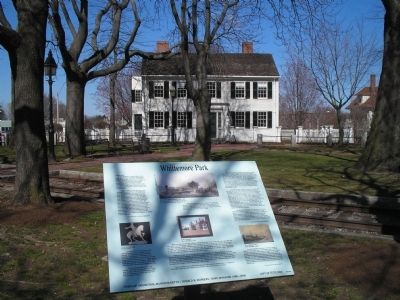
On April 19, 1775, the house before you was the home of Jacob and Esther Whittemore and their four children. Although they were not involved in the battle, local tradition tells that a British soldier was shot and killed in front of the blacksmith . . . — — Map (db m18246) HM
Through this place passed General Henry Knox in the winter of 1775 – 1776 to deliver to General George Washington at Cambridge the train of artillery from Fort Ticonderoga used to force the British Army to evacuate Boston. Erected by the . . . — — Map (db m17940) HM
Site of first meeting house completed in 1662, Rev. William Brimsmead Minister. It was built within the limits of the Indian planting field which was part of the Ockoocangansett Plantation, and was a source of hostile feelings toward the settlers. . . . — — Map (db m66595) HM
On the night of April 18-19, 1775, on his famous ride to Lexington, Paul Revere tethered his horse here and awakened Captain Hall of the Medford Minute Men to tell him that "The Regulars are out." — — Map (db m82651) HM
369 entries matched your criteria. Entries 101 through 200 are listed above. ⊲ Previous 100 — Next 100 ⊳