After filtering for New Hampshire, 60 entries match your criteria.
US Revolutionary War Topic
By Kelly Marsh, September 9, 2023
Jonathan Chesley Marker
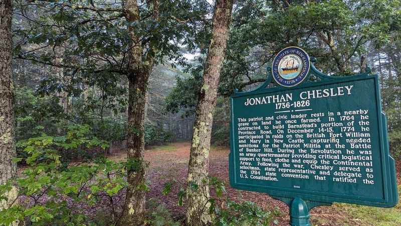
| 1 ► New Hampshire, Belknap County, Barnstead — 0201 — Jonathan Chesley — 1736 - 1826 — |
| On S Barnstead Road (New Hampshire Route 126) north of Gray Road, on the left when traveling north. | |||
| 2 ► New Hampshire, Cheshire County, Fitzwilliam — Brigadier General James Reed — |
| On New Hampshire Route 119 at Templeton Turnpike, on the left when traveling south on State Route 119. | |||
| 3 ► New Hampshire, Cheshire County, Fitzwilliam — 99 — Brigadier General James Reed — (1722-1807) — |
| On New Hampshire Route 119 west of Templeton Turnpike, on the left when traveling west. | |||
| 4 ► New Hampshire, Cheshire County, Keene — The Old Fort — |
| On Main Street (New Hampshire Route 12) north of Gates Street, on the right when traveling north. | |||
| 5 ► New Hampshire, Cheshire County, Keene — The Old Road to Boston — |
| On Main St. (New Hampshire Route 12) at Baker Street, on the right when traveling north on Main St.. | |||
| 6 ► New Hampshire, Cheshire County, Winchester — Winchester Community Park — |
| On Main Street (New Hampshire Route 10/119) north of Parker Street, on the right when traveling north. | |||
| 7 ► New Hampshire, Coos County, Lancaster — First Church of Lancaster — |
| On Portland Street (U.S. 2) at Prospect Street (U.S. 3), on the left when traveling west on Portland Street. | |||
| 8 ► New Hampshire, Coos County, Lancaster — Lancaster War Memorial — |
| On Prospect Street (U.S. 3) at Portland Street (U.S. 2), in the median on Prospect Street. | |||
| 9 ► New Hampshire, Grafton County, Enfield — Enfield Revolutionary War Monument — |
| On New Hampshire Route 4 near High Street, on the left when traveling east. | |||
| 10 ► New Hampshire, Grafton County, Haverhill, North Haverhill — 104 — Ebenezer MacKintosh — 1737-1816 — |
| On Darthmouth College Highway at Horse Meadow Road on Darthmouth College Highway. | |||
| 11 ► New Hampshire, Grafton County, Lebanon — Lebanon Soldiers of the American Revolution — |
| On North Park Street at Bank Street, on the right when traveling east on North Park Street. | |||
| 12 ► New Hampshire, Grafton County, Plymouth — Revolutionary War Cannon — |
| On Main Street (U.S. 3) at Court Street, on the right when traveling south on Main Street. | |||
| 13 ► New Hampshire, Hillsborough County, Hillsborough — Hillsborough War Memorial — |
| On School Street north of Myrtle Street, on the right when traveling north. | |||
| 14 ► New Hampshire, Hillsborough County, Hillsborough — 065 — Pierce Homestead — |
| On Second New Hampshire Turnpike (New Hampshire Route 31) 0.1 miles north of West Main Street, on the right when traveling north. | |||
| 15 ► New Hampshire, Hillsborough County, Manchester, Downtown — Brigadier General John Stark — 1728 - 1822 — Victor of the Battle of Bennington 1777 — |
| On Market Street east of Franklin Street, on the left when traveling east. | |||
| 16 ► New Hampshire, Hillsborough County, Manchester, Downtown — Manchester NH General Pulaski Monument — |
| On Bridge Street at Union Street, on the right on Bridge Street. | |||
| 17 ► New Hampshire, Hillsborough County, Milford — Captain Josiah Crosby / Lieutenant Thompson Maxwell — |
| On Emmerson Road east of New Hampshire Route 13, on the left when traveling east. | |||
| 18 ► New Hampshire, Hillsborough County, New Boston — 0146 — Home of the Molly Stark Cannon — |
| 19 ► New Hampshire, Hillsborough County, Temple — Village Cemetery — |
| On Gen. Miller Highway at Cemetery Lane, on the right when traveling north on Gen. Miller Highway. | |||
| 20 ► New Hampshire, Hillsborough County, Weare — Pine Tree Riot — |
| On South Stark Highway (New Hampshire Route 114) 0.1 miles south of Orchard Hill Road, on the right when traveling south. | |||
| 21 ► New Hampshire, Hillsborough County, Weare — Site of Pine Tree Tavern — 1772 • 1928 — |
| On South Stark Highway (New Hampshire Route 114) 0.1 miles south of Orchard Hill Road, on the right when traveling south. | |||
| 22 ► New Hampshire, Merrimack County, Canterbury — Henry Parkinson, A. M. — |
| On NW Road (Route 132) 0.1 miles south of Rum Brook Road, on the right when traveling south. | |||
| 23 ► New Hampshire, Merrimack County, Concord — Lafayette Posts — |
| On Industrial Drive at S Fruit Street, on the left when traveling east on Industrial Drive. | |||
| 24 ► New Hampshire, Merrimack County, Concord — Maj. Gen. John Stark — |
| On North Main Street at Capitol Street, on the right when traveling south on North Main Street. | |||
| 25 ► New Hampshire, Merrimack County, Dunbarton — 0111 — Molly Stark House — |
| On Stark Highway South (New Hampshire Route 13) at New Hampshire Route 77, on the right when traveling south on Stark Highway South. | |||
| 26 ► New Hampshire, Merrimack County, Epsom — Major Andrew McClary — |
| On Dover Road (U.S. 202), on the right when traveling west. | |||
| 27 ► New Hampshire, Merrimack County, New London — New London War Memorial — |
| On Main Street (New Hampshire Route 114) at Seamans Road, on the left when traveling south on Main Street. | |||
| 28 ► New Hampshire, Rockingham County, Candia — Soldier's Memorial — |
| On Healey Road, on the right. | |||
| 29 ► New Hampshire, Rockingham County, Chester — Chester American Revolutionary War Memorial — |
| On Haverhill Road (New Hampshire Route 121) at Raymond Road (New Hampshire Route 102), on the left when traveling west on Haverhill Road. | |||
| 30 ► New Hampshire, Rockingham County, Chester — Early American Clocks — |
| On Chester Street (New Hampshire Route 121) at Raymond Road (New Hampshire Route 102), on the left when traveling east on Chester Street. | |||
| 31 ► New Hampshire, Rockingham County, Deerfield — 25 — Major John Simpson — |
| On North Road (New Hampshire Route 107) at Meeting House Hill Road, on the left when traveling north on North Road. | |||
| 32 ► New Hampshire, Rockingham County, Exeter — 131 — Brigadier General Enoch Poor — |
| On Newfields Road (New Hampshire Route 85), on the right when traveling north. | |||
| 33 ► New Hampshire, Rockingham County, Exeter — 097 — Exeter Town House — |
| On Front Street at Court Street, on the right when traveling north on Front Street. | |||
| 34 ► New Hampshire, Rockingham County, Exeter — 161 — Ladd-Gilman House — |
| On Water Street, on the right. | |||
| 35 ► New Hampshire, Rockingham County, Exeter — Powder House — — 1771 — — |
| Near Jady Hill Avenue. | |||
| 36 ► New Hampshire, Rockingham County, Exeter — Powder House — — 1771 — — |
| On Swasey Parkway, on the right when traveling north. | |||
| 37 ► New Hampshire, Rockingham County, Exeter — 032 — Revolutionary Capital — |
| On Front Street, on the right when traveling north. | |||
| 38 ► New Hampshire, Rockingham County, Fremont — Fremont Village Cemetery — Est. 1819 — |
| On Main Street (New Hampshire Route 107) 0.2 miles north of Scribner Road, on the left when traveling north. | |||
| 39 ► New Hampshire, Rockingham County, Fremont — Historic Black Rocks Village / Historic Fremont, N.H.-Olde Poplin — |
| On Main Street (New Hampshire Route 107) south of Sandown Road, on the right when traveling south. | |||
| 40 ► New Hampshire, Rockingham County, Fremont — John Prescott Lovering's Inn — circa 1756 — |
| On Main Street (New Hampshire Route 107) at Sandown Road, on the right when traveling north on Main Street. | |||
| 41 ► New Hampshire, Rockingham County, Kingston — 046 — Josiah Bartlett — — 1729–1795 — — |
| On West Main Street, on the right when traveling north. | |||
| 42 ► New Hampshire, Rockingham County, New Castle — Fort William and Mary Commemoration Marker — |
| Near Wentworth Road. | |||
| 43 ► New Hampshire, Rockingham County, New Castle — Portcullis — |
| Near Sullivan Lane, 0.2 miles east of Wentworth Road. | |||
| 44 ► New Hampshire, Rockingham County, New Castle — 004 — William and Mary Raids — |
| On Wentworth Road at Ocean Street, on the right when traveling west on Wentworth Road. | |||
| 45 ► New Hampshire, Rockingham County, Northwood — 024 — LaFayette's Tour — |
| On U.S. 4. | |||
| 46 ► New Hampshire, Rockingham County, Nottingham — 0259 — Nottingham Square — |
| On Raymond Road (New Hampshire Route 156) at Ledge Farm Road, on the right when traveling north on Raymond Road. | |||
| 47 ► New Hampshire, Rockingham County, Portsmouth — 18 Congress — |
| On Congress Street. | |||
| 48 ► New Hampshire, Rockingham County, Portsmouth — In This House Admiral (John) Paul Jones Resided — |
| On Middle Street (U.S. 1) north of State Street, on the right when traveling north. | |||
| 49 ► New Hampshire, Rockingham County, Portsmouth — James (Stavers) — Portsmouth Black Heritage Trail — |
| On Atkinson Street at Court Street on Atkinson Street. | |||
| 50 ► New Hampshire, Rockingham County, Portsmouth — Joseph & Nancy (Cotton) and their children, Eleazor & James — Portsmouth Black Heritage Trail — |
| On State Street (U.S. 1) at Court Place, on the right when traveling north on State Street. | |||
| 51 ► New Hampshire, Rockingham County, Portsmouth — Portsmouth Pier & Wharves — |
| Near State Street north of Marcy Street, on the right when traveling north. | |||
| 52 ► New Hampshire, Rockingham County, Portsmouth — Prince Whipple and Winsor Moffatt — Revolutionary Petitioners — Portsmouth NH Black Heritage Trail — |
| On Market Street, on the left. | |||
| 53 ► New Hampshire, Rockingham County, Portsmouth — The Continental Frigate "Raleigh" — |
| On Middle Street (U.S. 1) north of State Street, on the right when traveling north. | |||
| 54 ► New Hampshire, Strafford County, Dover — 165 — The Alexander Scammell Bridge over the Bellamy River — |
| On Boston Harbor Rd. (U.S. 4 at milepost 101.6), on the right when traveling east. | |||
| 55 ► New Hampshire, Strafford County, Durham — 89 — Major General John Sullivan — 1740-1795 — |
| On Newmarket Road (New Hampshire Route 108), on the left when traveling west. | |||
| 56 ► New Hampshire, Strafford County, Durham — Major General John Sullivan Memorial — |
| On Newmarket Road. | |||
| 57 ► New Hampshire, Sullivan County, Charlestown — 117 — General John Stark's Expedition to Bennington — August 1777 — |
| On Main Street (SR 12) at Elm Street on Main Street (SR 12). | |||
| 58 ► New Hampshire, Sullivan County, Charlestown — Liberty Tree Memorial — |
| On Main Street (New Hampshire Route 12) north of Olcott Lane, on the left when traveling north. | |||
| 59 ► New Hampshire, Sullivan County, Claremont — 22 — Lafayette's Tour — Mapping the Farewell Tour™ — The Lafayette Trail — |
| On Opera House Square at Pleasant Street (New Hampshire Route 11/12), in the median on Opera House Square. | |||
| 60 ► New Hampshire, Sullivan County, Cornish — 8 — Lafayette's Tour — Mapping the Farewell Tour™ — The Lafayette Trail — |
| On New Hampshire Route 12A south of the Cornish-Windsor Covered Bridge, on the left when traveling north. | |||