1110 entries match your criteria. The first 100 are listed. ⊳
Cold War Topic
By Mike Wintermantel, May 28, 2023
USS Chilton marker
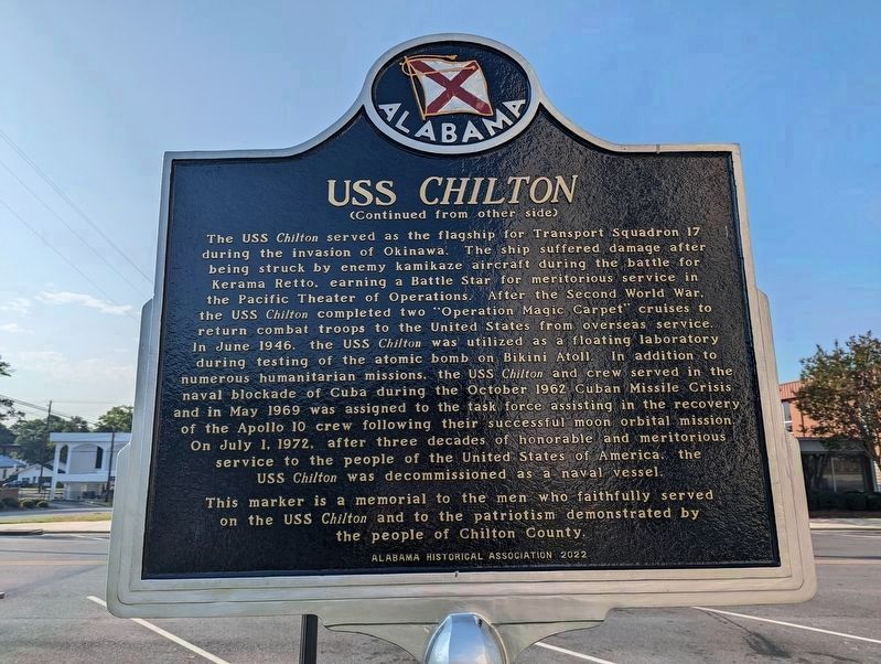
| 1 ► Alabama, Chilton County, Clanton — USS Chilton — |
| On 2nd Avenue North west of 5th Avenue South, on the right when traveling west. | |||
| 2 ► Alabama, Lauderdale County, Florence — “Gooney Bird” Propeller — |
| On Veterans Park Drive, 0.3 miles east of South Cox Creek Parkway (Alabama Route 133), on the left when traveling east. | |||
| 3 ► Alabama, Lauderdale County, Florence — Lieutenant Colonel R. Edward Yeilding — United States Air Force — |
| On Veterans Park Drive, 0.2 miles east of South Cox Creek Parkway (Alabama Route 133), on the left when traveling east. | |||
| 4 ► Alabama, Lee County, Auburn — Advancing American Art Collection — |
| On Woodfield Drive, on the right when traveling east. | |||
| 5 ► Alabama, Madison County, Huntsville — Cold War-Global 1945-/ Cold War-Germany 1945-1990 — |
| Near Monroe Street Northwest at Jefferson Street North, on the left when traveling east. | |||
| 6 ► Alabama, Madison County, Huntsville — Korean War / Cold War-Korea 1953- — |
| Near Monroe Street Northwest at Jefferson Street North, on the left when traveling east. | |||
| 7 ► Alabama, Madison County, Huntsville — Main Engines — Power for Lift-off and Ascent to Orbit — |
| Near Tranquility Base, 0.4 miles west of Madison Pike, on the left when traveling west. | |||
| 8 ► Alabama, Madison County, Huntsville — NASA / U.S. Geological Survey — Mobile Geological Laboratory — |
| Near Tranquiltiy Base, 0.5 miles Madison Pike, on the left when traveling west. | |||
| 9 ► Alabama, Madison County, Huntsville — NASA Skylab — |
| Near Tranquility Base, 0.5 miles west of Madison Pike, on the left when traveling west. | |||
| 10 ► Alabama, Madison County, Huntsville — Pathfinder — Huntsville's Orbiter for NASA's Fleet — |
| Near Tranquility Base, 0.4 miles west of Madison Pike, on the left when traveling west. | |||
| 11 ► Alabama, Madison County, Huntsville — Pathfinder Orbiter — Shuttle “Body Double” — |
| Near Tranquility Base, 0.5 miles west of Madison Pike, on the left when traveling west. | |||
| 12 ► Alabama, Madison County, Huntsville — T-38 Talon — Supersonic Jet Trainer — |
| Near Tranquilty Base, 0.4 miles west of Madison Pike, on the left when traveling west. | |||
| 13 ► Alabama, Madison County, Huntsville — U.S. Air Force SM-65 Atlas-F — |
| Near Tranquility Base, 0.5 miles west of Madison Pike, on the left when traveling west. | |||
| 14 ► Alabama, Madison County, Huntsville — U.S. Army PGM-11 Redstone — |
| Near Tranquiltiy Base, 0.5 miles west of Madison Pike, on the left when traveling west. | |||
| 15 ► Alabama, Madison County, Huntsville — U.S. Army PGM-19 Jupiter — |
| Near Tranquilty Base, 0.5 miles west of Madison Pike, on the left when traveling west. | |||
| 16 ► Alabama, Montgomery County, Maxwell Air Force Base — Air University Commanders — |
| On Maxwell Boulevard at Magnolia Drive, on the right when traveling west on Maxwell Boulevard. | |||
| 17 ► Alabama, Montgomery County, Maxwell Air Force Base — Boeing B-52D "Stratofortress" — |
| On Twining Street north of Ash Street, on the left when traveling north. | |||
| 18 ► Alabama, Montgomery County, Maxwell Air Force Base — Establishment of Air University 1946 — |
| On Maxwell Boulevard at Magnolia Drive, on the right when traveling west on Maxwell Boulevard. | |||
| 19 ► Alabama, Montgomery County, Maxwell Air Force Base — Expansion of Air University — |
| On Maxwell Boulevard at Magnolia Drive, on the right when traveling west on Maxwell Boulevard. | |||
| 20 ► Alabama, Montgomery County, Maxwell Air Force Base — General Larry D. Welch — 12th Chief of Staff of the United States Air Force — Served 1951 - 1990, Aviation Cadet 1953 — |
| 21 ► Alabama, Montgomery County, Maxwell Air Force Base — Joint Programs — |
| On Maxwell Boulevard at Magnolia Drive, on the right when traveling west on Maxwell Boulevard. | |||
| 22 ► Alabama, Montgomery County, Maxwell Air Force Base — McDonnell Douglas F-4D "Phantom II" — |
| On Chennault Circle east of Twining Street, on the left when traveling east. | |||
| 23 ► Alabama, Montgomery County, Maxwell Air Force Base — McDonnell RF-101C "Voodoo" — |
| On Chennault Circle east of Twining Street, on the left when traveling east. | |||
| 24 ► Alabama, Montgomery County, Maxwell Air Force Base — North American F-100D "Super Sabre" — |
| On Chennault Circle east of Twining Street, on the left when traveling east. | |||
| 25 ► Alabama, Montgomery County, Maxwell Air Force Base — North American F-86A "Sabre" — |
| On Poplar Street south of Chennault Circle, on the left when traveling south. | |||
| 26 ► Alabama, Montgomery County, Maxwell Air Force Base — Northrop T-38A "Talon" — |
| On Poplar Street at Maxwell Boulevard, on the left when traveling north on Poplar Street. | |||
| 27 ► Alabama, Montgomery County, Maxwell Air Force Base — Reorganization — |
| On Maxwell Boulevard at Magnolia Drive, on the right when traveling west on Maxwell Boulevard. | |||
| 28 ► Alabama, Montgomery County, Maxwell Air Force Base — Reorganization — |
| On Maxwell Boulevard at Magnolia Drive, on the right when traveling west on Maxwell Boulevard. | |||
| 29 ► Alabama, Montgomery County, Maxwell Air Force Base — Republic F-105D "Thunderchief" — |
| On Chennault Circle east of Twining Street, on the left when traveling east. | |||
| 30 ► Alabama, Montgomery County, Maxwell Air Force Base Gunter Annex — Award of Air Force Cross to Jon D. Harston — |
| Near McDonald Street at Avenue D. | |||
| 31 ► Alabama, Montgomery County, Maxwell Air Force Base Gunter Annex — Award of Air Force Cross to Timothy A. Wilkinson — |
| Near McDonald Street at Avenue D. | |||
| 32 ► Arizona, Pima County, Green Valley — Titan II Intercontinental Ballistic Missile Museum — |
| Near West Duval Mine Road. | |||
| 33 ► Arkansas, Benton County, Bella Vista — Cold War — |
| 34 ► Arkansas, Benton County, Bella Vista — United States Commanders in Chief — |
| 35 ► Arkansas, Benton County, Rogers — F-101B Voodoo — |
| On Hudson Road (U.S. 62) at Cass Hough Drive, on the left when traveling north on Hudson Road. | |||
| 36 ► Arkansas, Carroll County, Eureka Springs — The Berlin Wall — Actual 10 x 10 Section — |
| 37 ► Arkansas, Lawrence County, Walnut Ridge — Honored to serve their Country — |
| On North Beacon Road, 0.1 miles north of Custom, on the left when traveling north. | |||
| 38 ► Arkansas, Washington County, Fayetteville — Replica of the Statue of Liberty — |
| On Monte Painter Drive west of Northhills Boulevard, on the left when traveling south. | |||
| 39 ► California, Los Angeles County, Lancaster — Colonel William J. “Pete” Knight — |
| On Lancaster Boulevard west of Date Avenue, on the right when traveling west. | |||
| 40 ► California, Los Angeles County, Lancaster — Lt. Gen. James H. "Jimmy" Doolittle — USAF, Retired — Aerospace Walk of Honor — |
| On Lancaster Boulevard, on the left when traveling west. | |||
| 41 ► California, Los Angeles County, Los Angeles, Encino — Nike Missile Site LA96C — |
| On Mulholland Drive, 1 mile west of Encino Hills Drive, on the left when traveling west. | |||
| 42 ► California, Los Angeles County, Los Angeles, Miracle Mile — Berlin Wall Segments — The Wall Project — |
| On Wilshire Boulevard east of Ogden Drive, on the right when traveling east. | |||
| 43 ► California, Los Angeles County, Los Angeles, San Pedro — 515 — Battery Osgood-Farley Historic Site — Home of the Fort MacArthur Museum — Battle Honors, Third Coast Artillery — |
| Near Leavenworth Drive west of South Gaffey Street, on the left when traveling west. | |||
| 44 ► California, Los Angeles County, Los Angeles, San Pedro — White Point Nike Missile Site — |
| On West Paseo Del Mar, 0.2 miles east of Western Avenue, on the right when traveling east. | |||
| 45 ► California, Los Angeles County, Los Angeles, Westlake — Hungarian Freedom Fight of 1956 — |
| On 6th Street at Park View Street, on the right when traveling east on 6th Street. | |||
| 46 ► California, Los Angeles County, Palmdale — Blackbird Air Park — Air Force Plant 42 — |
| On East Avenue P at 25th Street East, on the right when traveling west on East Avenue P. | |||
| 47 ► California, Marin County, Sausalito — Mortars to Missiles — Military power at the Golden Gate |
| On Conzelman Road at Field Road, on the left on Conzelman Road. Reported missing. | |||
| 48 ► California, Marin County, Sausalito — Nike Missile Site SF88 — |
| On Field Road near Conzelman Road, on the right when traveling west. | |||
| 49 ► California, Marin County, Sausalito, Fort Barry — Battery Alexander — |
| Near Field Road west of Rathbone Road, on the right when traveling west. | |||
| 50 ► California, Marin County, Sausalito, Fort Cronkhite — Marin Headlands — An Army Legacy: A Landscape Preserved — |
| On Mitchell Road west of Kirkpatrick Street, on the right when traveling west. | |||
| 51 ► California, Marin County, Tiburon — Ayala Cove — |
| 52 ► California, Marin County, Tiburon — Cold War Defense |
| On Perimeter Road, on the left when traveling east. Reported permanently removed. | |||
| 53 ► California, Marin County, Tiburon — Nike Missile Site — |
| 54 ► California, Mono County, Lee Vining — Navy Beach — |
| On State Highway 120 at the South Tufa Area Entrance Road, on the left when traveling east on State Highway 120. | |||
| 55 ► California, Orange County, Anaheim — Boeing Autonetics — Anaheim, Calif. — |
| On La Palma Avenue, 0.2 miles east of Kraemer Boulevard, on the left when traveling east. | |||
| 56 ► California, Orange County, Mission Viejo — Men's Individual Road Race — |
| On Olympiad Road west of Marguerite Parkway, on the right when traveling east. | |||
| 57 ► California, Orange County, Westminster — "7" Not Forgotten American Hostages in Lebanon — |
| Near Westminster Boulevard. | |||
| 58 ► California, Orange County, Westminster — Battle of the Paracel Islands Memorial — |
| Near All American Way. | |||
| 59 ► California, Riverside County, Blythe — 127 — Desert Strike — |
| On Midland Road, 10 miles north of Interstate 10, on the right when traveling north. | |||
| 60 ► California, Riverside County, Palm Springs — McDonnell Douglas A-4 Skyhawk — |
| Near North Gene Autry Trail. | |||
| 61 ► California, Sacramento County, Sacramento — McClellan Air Force Base — |
| On Arnold Avenue, on the right when traveling north. | |||
| 62 ► California, San Bernardino County, Ludlow — 139 — Project Carryall — |
| On National Trails Highway at Crucero Road, on the right when traveling east on National Trails Highway. | |||
| 63 ► California, San Diego County, San Diego, Palisades — A-12 Blackbird 06933 — |
| Near Pan American Plaza. | |||
| 64 ► California, Santa Barbara County, Santa Maria — Santa Maria Valley Cold War Veterans Memorial — |
| On South McClelland Street at West Boone Street, on the right when traveling north on South McClelland Street. | |||
| 65 ► California, Santa Barbara County, Vandenberg Space Force Base — Ronald W. Reagan Missile Defense Site — |
| On Orion Road, on the left. | |||
| 66 ► California, Santa Barbara County, Vandenberg Space Force Base — Vandenberg Air Force Base — AIAA Historic Aerospace Site — |
| On California Boulevard at Oregon Avenue, on the right when traveling south on California Boulevard. | |||
| 67 ► California, Santa Clara County, Twin Creeks, Almaden — Military Community — |
| Near Mount Umunhum Road near Mount Umunhum-Loma Prieta Road, on the left when traveling north. | |||
| 68 ► California, Santa Clara County, Twin Creeks, Almaden — Scanning the Skies — |
| Near Mount Umunhum Road near Mount Umunhum-Loma Prieta Road. | |||
| 69 ► California, Tuolumne County, Sonora — Veterans Memorial Building — Dedicated 1933 — Tuolumne County War Memorials — |
| On North Washington Street (State Highway 49) at East Jackson Street, on the right when traveling north on North Washington Street. | |||
| 70 ► Colorado, Adams County, Commerce City — Headquarters for a New Mission — |
| On East 72nd Avenue, on the left when traveling east. | |||
| 71 ► Colorado, Adams County, Commerce City — On This Site Stood the "White House" — |
| On East 72nd Avenue, on the left when traveling east. | |||
| 72 ► Colorado, Adams County, Commerce City — Rocky Mountain Arsenal National Wildlife Refuge — |
| Near Havana Street (Wildlife Drive), 0.6 miles north of East 64th Avenue (Wildlife Drive), on the right when traveling north. | |||
| 73 ► Colorado, El Paso County, United States Air Force Academy — Airman and Winged Refuge — |
| 74 ► Colorado, El Paso County, United States Air Force Academy — Winged Refuge and Airman — |
| 75 ► Colorado, El Paso County, United States Air Force Academy — 19th Troop Carrier Squadron — Southern Cross Airways — |
| 76 ► Colorado, El Paso County, United States Air Force Academy — 2nd Bomb Wing Association — Libertatem Defendimus — |
| 77 ► Colorado, El Paso County, United States Air Force Academy — 22d Bombardment Wing (SAC) — 15th Air Force — |
| 78 ► Colorado, El Paso County, United States Air Force Academy — 27th Fighter Wing — |
| 79 ► Colorado, El Paso County, United States Air Force Academy — 307th Bomb Wing — Lincoln AFB, Nebraska — 1954 - 1965 — |
| 80 ► Colorado, El Paso County, United States Air Force Academy — 308th Bomb Wing — 373rd • 374th • 375th Bomb Squadons • • 308th Air Refueling Squadon — Hunter AFB, GA • 1952 - 1959 — |
| 81 ► Colorado, El Paso County, United States Air Force Academy — 320th Air Refueling Squadron — |
| 82 ► Colorado, El Paso County, United States Air Force Academy — 33rd Fighter Squadron — GHQ Air Force • 8th Pursuit Group • Iceland Base Command — Air Force Combat Command — |
| 83 ► Colorado, El Paso County, United States Air Force Academy — 36th Tactical Fighter Wing — Bitburg Air Base, Germany — 1953-1994 — |
| 84 ► Colorado, El Paso County, United States Air Force Academy — 43rd Bombardment Wing / 305th Bombardment Wing — |
| 85 ► Colorado, El Paso County, United States Air Force Academy — 44th Bomb Group (H) — "Flying Eightball Group" — "Aggressor Beware" — |
| 86 ► Colorado, El Paso County, United States Air Force Academy — 48th Fighter-Bomber Wing — Chaumont, France — 1952 - 1959 — |
| 87 ► Colorado, El Paso County, United States Air Force Academy — 509 Composite Bomb Group • 509th Bomb Wing — 20th Air Force • 2nd Air Force • 8th Air Force — |
| 88 ► Colorado, El Paso County, United States Air Force Academy — 64th Fighter Squadron — |
| 89 ► Colorado, El Paso County, United States Air Force Academy — 96 Bomb Group/Wing — In Memoriam — |
| 90 ► Colorado, El Paso County, United States Air Force Academy — 98th Bomb Group — Force For Freedom — |
| 91 ► Colorado, El Paso County, United States Air Force Academy — Albrook and Howard Air Force Base — Panama Canal Zone — In Memory of Those Who Served — |
| 92 ► Colorado, El Paso County, United States Air Force Academy — B-52D Stratofortress — "Diamond Lil" — 1957 - 1983 — |
| On North Gate Boulevard at Stadium Boulevard, on the left when traveling west on North Gate Boulevard. | |||
| 93 ► Colorado, El Paso County, United States Air Force Academy — Berlin Airlift Veterans — |
| 94 ► Colorado, El Paso County, United States Air Force Academy — Falcon Stadium — Dedicated October 20, 1962 — |
| 95 ► Colorado, El Paso County, United States Air Force Academy — Freedom Through Vigilance Association — |
| 96 ► Colorado, El Paso County, United States Air Force Academy — Howard J. Withycombe Memorial Pavilion Courtyard — |
| 97 ► Colorado, El Paso County, United States Air Force Academy — Navigators and Observers — |
| 98 ► Colorado, El Paso County, United States Air Force Academy — Sidefire Gunships — |
| 99 ► Colorado, El Paso County, United States Air Force Academy — The Cold War Begins — Air Warrior Combat Memorial — |
| Near Stadium Boulevard at North Gate Boulevard, on the right when traveling north. | |||
| 100 ► Colorado, El Paso County, United States Air Force Academy — USAF Academy Cemetery Carillon — |
| On Parade Loop west of Stadium Boulevard, on the right when traveling west. | |||
1110 entries matched your criteria. The first 100 are listed above. Next 100 ⊳