On South San Marcos Place at West Boston Street, on the right when traveling south on South San Marcos Place.
Hotel Chandler, 1914
Chandler Historic Commercial District on the National Register of Historic Places
The second story of this building was the Hotel Chandler, an affordable alternative to the luxurious San Marcos Hotel. Starting in 1917, . . . — — Map (db m72133) HM
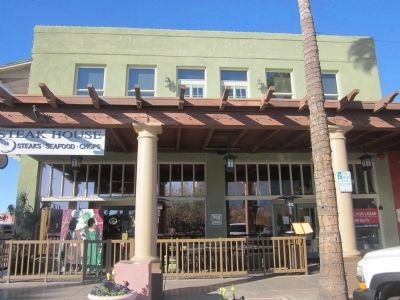
On South San Marcos Place just south of West Commonwealth Avenue, on the right when traveling south.
Monroe Building, 1912
Chandler Historic Business District on the National Register of Historic Places
Built by the Chandler Improvement Company, this building is named for merchant M. E. Monroe, who opened the Monroe Hardware Store in the . . . — — Map (db m71001) HM
On San Marcos Place just south of West Commonwealth Avenue, on the right when traveling south.
Morrison Grocery, 1912
Chandler Historic Business District on the National Register of Historic Places
Ernest and Leroy Morrison opened the Chandler’s first grocery here in 1912. The building has been host to a series of grocery stores, the . . . — — Map (db m71003) HM
On West Buffalo, on the right when traveling west.
Suhwaro Hotel, 1916
Listed on the National Register of Historic Places
This Spanish Mission Revival building had many uses, including a hotel, school and bowling alley. The San Marcos Hotel purchased the Suhwaro Hotel in 1924 for staff . . . — — Map (db m49867) HM
On North Gilbert Road, on the right when traveling south.
This building was originally the Creed Store. The 1923 picture below is of Raymond R. Creed who served as the Mayor of Gilbert in 1925. Ethel Hoffman Lacy, shown in the center of the photo, was the postmaster at this time. Winnie Johnson, wife of . . . — — Map (db m88070) HM
On North Gilbert Road, on the right when traveling north.
The Gilbert town hall was built in 1938 to serve the area's 1400 residents. This building consisted of a fire station with a jail behind it. The courthouse and council chambers were also in the building. On January 2, 1938, Congress approved the . . . — — Map (db m88082) HM
On West Page Avenue, on the right when traveling east.
In 1925 the well for Gilbert’s domestic water was drilled to the depth of 475 feet where a large flow of pure water was found. A six-inch pipe was sunk to bring the water to the surface. The tower and pumping station were constructed during the . . . — — Map (db m90238) HM
On North Gilbert Road at East Page Avenue, on the right when traveling north on North Gilbert Road.
The Bank of Gilbert was built in 1917. One of the men instrumental in the creation of the bank was Abe Cosby (pictured below on right) who came to Gilbert to invest in land and open a real estate office. Bill Andersen, (shown of left) one of the . . . — — Map (db m88069) HM
This house, which is the oldest building at Sahuaro Ranch, is believed to have been built in 1887, one year after William Bartlett started the ranch. It was constructed of adobe bricks made here at the ranch, possibly using dirt that was excavated . . . — — Map (db m40639) HM
On West Glendale Avenue east of North 58th Drive, on the right when traveling east.
C. L. Gillett, businessman and member of the first Glendale City Council, built this two-story brick building. The first floor was used for businesses, and the second floor was used as a meeting hall. E. J. Fiock bought the building in 1910, for his . . . — — Map (db m30438) HM
On North 58th Drive south of West Glendale Avenue, on the right when traveling north.
On November 14, 1940, Tom Coury signed an agreement with building contractor, H. D. McNeely, and the Glendale Lumber Company to construct a 42' x 65' brick building at a cost of $3,911. Upon completion of the building, Smart and Final Wholesale . . . — — Map (db m30439) HM
On North 58th Drive south of West Glendale Avenue, on the left when traveling north.
This structure was built in 1909 as the north half of the Hotchkiss building. It was a pool hall prior to 1918, when C. H. Tinker (Mayor 1918-20) purchased and remodeled it for his Security State Bank which he renamed The First National Bank of . . . — — Map (db m171615) HM
Near West Mountain View Road west of North 59th Avenue.
Built sometime around the turn of the 20th century, this house was the last residence to be constructed at Sahuaro Ranch.
Little is known about who lived in the house, but it appears to have been built as a residence for the employees of William . . . — — Map (db m40688) HM
On West Glendale Avenue east of North 63rd Avenue, on the right when traveling west.
This property
is listed in the
National Register
of Historic Places
By the United States
Department of the Interior
Glendale High School
Auditorium
1939 — — Map (db m30481) HM
On West Glenn Drive at North 56th Avenue, on the right when traveling east on West Glenn Drive.
This property is listed in the
National Register
of Historic Places
By the United States Department of the Interior
Listed July 7, 1989
In 1901, a small group of pioneer women organized the Self Culture Club of Glendale with the . . . — — Map (db m30478) HM
On West Glendale Avenue at North 58th Avenue, on the right when traveling east on West Glendale Avenue.
Mrs. Alice S. Hine, an agent for the Phoenix Title and Trust Company, hired a contractor by the name of Home Builders Company to build the two-story masonry structure in 1913. In 1919, Mrs. Hine added a substantial addition to the building along . . . — — Map (db m30435) HM
On West Glendale Avenue east of North 58th Drive, on the right when traveling east.
Brethren businessmen S. Humphrey and A. Davidson, the largest agricultural shipping agents in the area, built this single-story brick commercial building to house their dry goods business. This building shifted Glendale's commercial focus from the . . . — — Map (db m30437) HM
The large house to the right, now known as the Main House, was the home of the superintendent who managed Sahuaro Ranch for its owner, William Bartlett. The oldest section, on the right, was built in 1891 as an office. In 1895 it was expanded and . . . — — Map (db m40622) HM
On North 58th Drive north of West Glenn Drive, on the right when traveling south.
This property is listed in the
National Register of Historic Places
By the United States Department of the Interior
Listed
January 11, 2006
The First United Methodist Church of Glendale was originally chartered as the Methodist . . . — — Map (db m30475) HM
On North 58th Avenue north of West Glendale Avenue, on the right when traveling north.
Robert W. Cole bought three lots on the east side of the park in 1919. He hired J. C. Howell, a local architect to design the two-story building, and Robert Fultz was the builder. Construction started in June of 1919, and finished in September of . . . — — Map (db m30434) HM
"The residence on the Ranch is not a characteristic Arizona farm houses, as it contains thirteen bedrooms, eight of which are equipped with baths. The house rambles over considerable territory and, in the summer, the lawn is a wonder of . . . — — Map (db m40636) HM
On North 58th Drive south of West Glendale Avenue, on the right when traveling north.
Floyd Holmes Sine came to Arizona in 1897. Sine is considered to be the father of Glendale's city water system. When he bought this site in 1910, it was the only public well and water system. He added a storage tank and supply lines to the . . . — — Map (db m30440) HM
On West Glendale Avenue east of North 58th Avenue, on the right when traveling east.
Floyd Homes Sine, builder of the Sine Brothers Hardware Building on 58th Drive, built this distinctive two-story masonry structure in 1926. The Glendale Furniture Company was the ground floor business, and the second floor was used as meeting space. . . . — — Map (db m30436) HM
On North 59th Drive south of West Glendale Avenue, on the right when traveling south.
This property is listed in the
National Register
of Historic Places
By the United States Department of the Interior
Listed January 11, 2006
Cullin H. Tinker, prominent banker, and mayor from 1916 to 1922 built the house in 1913, . . . — — Map (db m30480) HM
On West Myrtle Avenue at Grand Avenue, on the right when traveling west on West Myrtle Avenue.
This property is listed in the
National Register
of Historic Places
By the United States Department of the Interior
Listed
April 6, 2006
Ed and Bessie Morcomb and their son Den acquired this property in 1935, as an 18-hole . . . — — Map (db m30495) HM
National Register
of Historic Places
Listed April 9, 1998
United Stated
Department of the Interior
Manistee Ranch a treasured Glendale landmark and was the long-time home of Louis M. Sands, a pioneer of modern Arizona cattle . . . — — Map (db m30500) HM
On North Center Street, on the right when traveling south.
Joel Sirrine arrived here in 1878 with the 'Mesa Company' of Pioneers. He constructed this house, which is Mesa's best example of Victorian architecture.
— — Map (db m49905) HM
On North 84th Avenue at West Jefferson Street, on the right when traveling north on North 84th Avenue.
In 1919, this building was constructed as a meeting place for the General Federation of Women's Clubs – Peoria Woman's Club.
Originally located at the northwest corner of 83rd Avenue and Washington Street, the Clubhouse was restored and . . . — — Map (db m30401) HM
Near West Jefferson Street, on the right when traveling east.
The 1897 Smurthwaite House is an excellent example of Shingle Style Architecture. It is one of fewer than one hundred 19th century buildings of this age left in Phoenix. It was donated to the City of Phoenix Park, Recreation and Library Department . . . — — Map (db m39414) HM
On North Central Avenue at West Monroe Street, on the right when traveling south on North Central Avenue.
Hotel San Carlos
1928
Has been placed on the Phoenix Historic
Property Register and the National
Register of Historic Places.
[An additional marker is mounted indoors between the elevators:]
San Carlos Hotel
The . . . — — Map (db m27614) HM
On West Washington Street at North 3rd Avenue, on the right when traveling west on West Washington Street.
The J. W. Walker/Central Arizona Light & Power Building was built in the spring and summer of 1920 by Phoenix businessman and real estate developer J. W. Walker. Designed by prominent early Phoenix architect L. M. Fitzhugh, the Neo-Classical Revival . . . — — Map (db m27628) HM
On West Washington Street at 1st Avenue when traveling south on West Washington Street.
The Maricopa County Courthouse was originally built in 1928-1929 by both Maricopa County and the City of Phoenix. The County Courthouse portion of the building was designed by a Louisiana architect. Edward F. Neild. The City chose the Phoenix firm . . . — — Map (db m73077) HM
Built in 1895 by Dr. Roland T. Rosson, Army doctor at Fort McDowell, Phoenix physician (1879-1897) and Mayor, this mansion is one of the few surviving examples of late Victorian architecture in Phoenix. It was acquired by the city through the . . . — — Map (db m27609) HM
Donated by Forest Burgess
To the city of Phoenix
November, 1976
This carriage house, originally located at 130 East Taylor, was owned by Forest Burgess and is all that remains of the Francis Marion Mognett Ranch which was established in . . . — — Map (db m27612) HM
Near South Ellsworth Road south of East Queen Creek Road.
In 1924 construction of a new schoolhouse began. Classes were being held in an old cook shack that had once been used by muleskinners to clear the land. The school, named after Charles Rittenhouse, would be a three-room, u-shaped building made of . . . — — Map (db m32393) HM
On Taliesin Drive, 1 mile north of Frank Lloyd Wright Boulevard.
Taliesin West, as part of the 20th-Century Architecture of Frank Lloyd Wright, has been inscribed on the World Heritage List.
Inscription confirms that this property deserves protection for the benefit of all humanity because of its . . . — — Map (db m188806) HM
On South Mill Avenue, on the right when traveling south.
Known as the Odd Fellows Hall when it was built in 1898, this building is the oldest surviving three story brick commercial building in Maricopa County. Its 2-story high ballroom, located on the second floor, has hosted several fraternal . . . — — Map (db m49913) HM
On North Tegner Street (Arizona Route 93), on the right when traveling north.
Has been entered in the
National Register
of Historic Places
By the United States
Department of the Interior
Little remains of the old one room schoolhouses built of log, adobe, frame or brick which proliferated across Arizona in . . . — — Map (db m29476) HM
On Frontier Street, on the right when traveling north.
The Old Brick
Post Office
Has been placed on the
National Register
of Historic Places
By the United States
Department of the Interior — — Map (db m29471) HM
On North Third Street at Pine Street, on the right when traveling south on North Third Street.
This building has been placed on
The National Register
of Historic Places
By the United States Department of the Interior.
A.T.&T. Building
Built 1930
A good example of Spanish Colonial Revival style with Federal Modern . . . — — Map (db m29395) HM
On East Spring Street west of North 5th Street, on the right when traveling east.
This building has been placed on
The National Register of
Historic Places
By the United States Department of the Interior.
Bonelli House
Built 1916
Built by George Bonelli, prominent Kingman citizen, this is an excellent . . . — — Map (db m29407) HM
On North 4th Street at East Oak Street, on the right when traveling south on North 4th Street.
This building has been placed on
The National Register of
Historic Places
By the United States Department of the Interior
Elks Lodge No.468
Built 1903 to 1904; modified 1913
The oldest lodge building in Kingman, this 1903-4 . . . — — Map (db m29405) HM
On North 1st Street at East Spring Street, on the left when traveling north on North 1st Street.
Moderne Style Structure Only Lamella Roof in Kingman Art Deco Detailing
National Register of Historic Places Plaque Donated by Heritage Crossroads 2003 — — Map (db m185213) HM
On East Andy Devine Avenue (Business Interstate 40), on the right when traveling west.
Constructed in 1909, Hotel Brunswick was built by prominent businessmen, John Mulligan and J. W. Thompson. Kingman's first three story building, constructed of local quarried tufa stone, featured 50 cowboy rooms with shared bath facilities, a dining . . . — — Map (db m29425) HM
On North 4th Street near East Oak Street, on the right when traveling south.
This building has been placed on
The National Register of
Historic Places
By the United States Department of the Interior.
Little Red Schoolhouse
Built 1896
Noteworthy for its age and integrity, the "Little Red Schoolhouse" is . . . — — Map (db m29422) HM
This building has been placed on
The National Register of
Historic Places
By the United States Department of the Interior
Mohave County Courthouse
Built 1915
Built of locally quarried tufa stone, the Mohave County Courthouse has . . . — — Map (db m29401) HM
This building has been placed on
The National Register of
Historic Places
By the United States Department of the Interior
Mohave County Jail
Built 1910
Noteworthy as one of the first cast-in-place concrete structures in . . . — — Map (db m29404) HM
On North 5th Street at East Spring Street, on the right when traveling north on North 5th Street.
This building has been placed on
The National Register of
Historic Places
By the United States Department of the Interior
St. John’s
United Methodist Church
Built 1917
Constructed of locally quarried tufa stone, this is the . . . — — Map (db m29408) HM
On East Spring Street east of North 3rd Street, on the right when traveling west.
This building has been placed on
The National Register of
Historic Places
By the United States Department of the Interior
St. Mary’s Catholic Church
Built 1906 – 1907
Constructed of locally quarried tufa stone, this . . . — — Map (db m29397) HM
On North 4th Street south of East Oak Street, on the right when traveling north.
This building has been placed on
The National Register of
Historic Places
By the United States Department of the Interior.
U.S. Post Office
Built 1935
A monument to massive federal building programs during the 1930's, . . . — — Map (db m29409) HM
On Oatman-Topock Highway at Rock Hound Road, on the right when traveling north on Oatman-Topock Highway.
This property has
been placed on the
National Registry of
Historic places of the
U.S. Dept. of Interior.
(Formally
Oatman Drug and
Health Club) — — Map (db m29465) HM
Near Petrified Forest Road, on the right when traveling north.
Did you notice where the trail passed over the faint outlines of the rooms? Over 100 rooms formed a one-story apartment complex surrounding a central plaza in the village. The building materials for the pueblo were blocks of native sandstone, shaped . . . — — Map (db m68887) HM
Near Petrified Forest Road, on the right when traveling north.
The village on the Rio Puerco (Puerco Pueblo) is a prehistoric settlement built of shaped sandstone blocks by ancestral Puebloan people. It was inhabited between A.D. 1250 and 1380. At its peak the pueblo had over 100 rooms, with a possible . . . — — Map (db m68881) HM
Near East 2nd Street / Old U.S. Route 66 Eastbound (Arizona Route 66) west of Interstate 40.
La Posada was the last of the great
Fred Harvey/Santa Fe Railway hotels.
This is the masterpiece of
Mary Jane Colter
considered by many to be
the greatest of all
Southwestern architects.
La Posada is on the National and State . . . — — Map (db m32787) HM
On South Stone Avenue, on the left when traveling south.
This house dating from the 1870s was purchased by Carlos and Beatriz Velasco in 1878. In the same year, Velasco began publication of the newspaper "El Fronterizo," which continued until his death in 1914. This building was the office and print . . . — — Map (db m150194) HM
On South Scott Avenue, on the right when traveling south.
This cultural center was built through the efforts of the Saturday Morning Music Club. The grand opening October 28, 1927, starred violinist Jascha Heifetz. Many world-renowned artists followed upon the stage and in the galleries while local talent . . . — — Map (db m26442) HM
On South Main Avenue, on the right when traveling south.
Carrillo School was named for the prominent Tucson businessman, Leopoldo Carrillo. During the 1880's, the site contained the Carrillo Gardens, the city's first park with eight acres of spring-fed artificial lakes, gardens and a recreational center. . . . — — Map (db m83016) HM
On South Meyer Avenue, on the right when traveling south.
Named for its founder, Carmen Soto Vásquez, this was one of the first theaters in Tucson devoted exclusively to the presentation of dramatic works in Spanish. From the opening night, May 20, 1915, with a performance of "Cerebro y . . . — — Map (db m83233) HM
On East Broadway Boulevard, on the right when traveling east.
Constructed in 1928, the tower is listed on the National Register of Historic Places and has been designated as a Tucson Landmark.
The tower's Spanish colonial revival sheathing was designed by Tucson architect Roy Place and added in 1932. . . . — — Map (db m26288) HM
On West Congress Street, on the right when traveling east.
The El Paso and Southwestern Railroad, originally owned by the Phelps Dodge Company, was extended from El Paso into Tucson in the fall of 1912. The handsome depot of classical design, featuring a large rotunda with a stained glass dome, was . . . — — Map (db m83028) HM
On West Congress Street, on the right when traveling west.
The Fox Tucson Theatre, the country's only southwestern art deco movie palace, was designed by California architect Eugene Durfee. Construction began in 1929 for the Tower Theatre, the crown jewel of the Diamos Brothers Southern Arizona Movie . . . — — Map (db m83033) HM
Near Church Avenue, on the right when traveling south.
The first Pima County Courthouse, a single-story adobe structure built in 1868, was replaced in 1881 by a large two-story stone and red brick victorian building which, in turn, was removed in 1928 to make way for the present structure. This . . . — — Map (db m55222) HM
On North Stone Avenue at East Pennington Street, on the right when traveling north on North Stone Avenue.
Façade restoration
44 North Stone Avenue
Original Architect - Roy Place (1887-1950)
Rededicated September 2010
Pima County 2004 Bond Funds
Façade restored to original 1929
design and appearance
Pima County Board of Supervisors
Ann . . . — — Map (db m84246) HM
On North Main Ave., on the right when traveling north.
E.N. Fish came to Arizona as an enterprising merchant in 1865. Three years later he built this adobe house which served as the family residence for the next half century. Fish developed many successful businesses and his wife Maria was prominent in . . . — — Map (db m83026) HM
On North Meyer Avenue at West Telles Street, on the right when traveling north on North Meyer Avenue.
This adobe house incorporates portions of one of the oldest standing structures in Tucson. The two west rooms are believed to have been built before the Gadsden Purchase of 1854. Four front rooms were added in 1879.
The house was named for . . . — — Map (db m83202) HM
On West Washington Street near North Meyer Avenue, on the right when traveling east.
This house is named for its first known residents, living here in 1868. Although construction dates are not known, the Washington Street wing lies along the course of the Presidio wall, completed in 1783. Leonardo Romero, a carpenter whose shop . . . — — Map (db m83203) HM
On North Main Avenue at West Paseo Redondo, on the right when traveling south on North Main Avenue.
From the 1860s to the early 1900s, many of the wealthiest families in Tucson built homes along Main Avenue (El Camino Real), from Alameda Street north to 6th Street. "La vecindad cerca del centro" or, "the neighborhood near downtown" soon earned the . . . — — Map (db m83205) HM
Near North Romero Road south of West Higgins Lane, on the left when traveling north.
The Tucson Plant Materials Center
Has been placed on the
National Register of Historic Places
By the United States
Department of Agriculture
1997 — — Map (db m31525) HM
Near North Campbell Avenue north of East River Road, on the right when traveling north.
This Property
is Listed in the
National Register
of Historic Places
By the United States Department of the Interior
St. Philip's in the Hills
1936 — — Map (db m31524) HM
Mission San Xavier del Bac was founded by the Jesuit missionary, Fr. Eusebio Kino in 1692. The present church was built under the direction of the Franciscans. Construction began in 1783 and was completed in 1797.
The church continues to . . . — — Map (db m83206) HM
On East Congress Street at South 5th Avenue, on the right when traveling west on East Congress Street.
The venerable Hotel Congress, designed by well-known architect, Roy Place, is the last surviving historic hotel in downtown Tucson. This three-story landmark was built in 1919 with exposed masonry construction and marble details. The hotel, south . . . — — Map (db m83200) HM
On March 12, 1885 Governor Frederick A. Tritle signed legislation creating the University of Arizona. Selim M. Franklin and C.C. Stephens, Pima delegates to the 13th Territorial Legislature fathered this Bill. Jacob S. Mansfeld solicited the . . . — — Map (db m26386) HM
Near West Florence Boulevard near North Sacaton Road.
This fieldstone structure was built in 1927 and served as the First Presbyterian Church until 1970. Rocks used in the construction were gathered from the desert and hauled to town. Renovation of the sanctuary was accomplished in 1984 and now serves . . . — — Map (db m27208) HM
On North Silver Street, on the right when traveling south.
This Sonoran-styled adobe house was built by rancher Andronico Loroña in 1886 and it is typical of the houses built in early Florence by ranchers. The original flat roof was replaced with a pitched roof covered with tin. Loroña lived here with his . . . — — Map (db m68358) HM
On East 8th Street, on the right when traveling east.
Completed in 1912, the Church of The Assumption is an example of the Mission Revival style of architecture. The third church built for Assumption Parish, it replaced the second church built on this site in 1884, which burned down in 1893. This . . . — — Map (db m26687) HM
On North Main Street near 8th Street, on the right when traveling south.
Town founder Levi Ruggles built a store on this site in 1876. In 1882, it became Peter Will's Brewery. It was demolished for the construction, in 1915, of the C. G. Powell People's Store, a single-story, commercial building. Prominent Phoenix . . . — — Map (db m26734) HM
On South Willow Street, on the right when traveling south.
This American-Victorian (Queen Anne) house was built in 1889, by its owner Charles D. Henry. Henry was a building contractor who specialized in brick and built other houses in Florence of similar architecture. These probably included the . . . — — Map (db m71773) HM
On South Main Street, on the right when traveling south.
Designed by Phoenix architects Royal W. Lescher and John R. Kibbey and completed in 1916, this neo-classical revival style structure has overtones of the Spanish revival style. The school board chose a one story as the children would have already . . . — — Map (db m26623) HM
On North Willow Street near 10th Street, on the right when traveling north.
The Florence Woman's Club was organized in 1897. In 1929, architects Lescher & Mahoney designed this Spanish Colonial Revival Style clubhouse. The original light fixtures are suspended from the ceiling, and an ornate Spanish-style fireplace is . . . — — Map (db m26746) HM
On West Ruggles Street, on the left when traveling west.
The smaller adobe outbuilding was constructed by Granville Wheat and appears on an 1869 army map of Florence. The flat earthen roof was replaced with a rare mono-pitched waterproof metal roof. The original door and wood frame remain. Wheat was a . . . — — Map (db m68341) HM
On South Main Street near Brady Street, on the right when traveling south.
This example of Early Transitional architecture combined Sonoran and Victorian elements. Built of adobe in 1880, the house was later veneered with red brick to give it a Victorian appearance. Physician William Harvey was known as an "Angel of Mercy" . . . — — Map (db m184138) HM
On North Silver Street, on the left when traveling south.
Ignacio Manjarres was a rancher in Florence as early as 1898 when a brand was registered in his name with the county. He was a charter member of the Pinal County Cattle Growers Association. At various times he raised sheep and pigs, fruit trees and . . . — — Map (db m68360) HM
On East 11th Street at North Baily Street, on the left when traveling west on East 11th Street.
In 1880, Juan Luna built this single-story, Sonoran-style adobe house for his wife and put the title in her name. According to Spanish tradition, it was the polite thing to do. The building's two L-shaped wings are one-room deep, and the original . . . — — Map (db m26791) HM
On North Willow Street near 9th Street, on the left when traveling north.
This single-story adobe, built in 1888, retains its basic integrity as an example of the symmetrical, pyramidal-roofed, Late-Transitional style. Keating was a pioneer stage driver. He served as a territorial legislator, Florence town councilman, and . . . — — Map (db m26803) HM
On North Baily Street, on the left when traveling north.
Called the "New Beer Hall," this single-story, mud-roofed, one-room deep, adobe Sonoran-style house was said to be "the coolest place in town" by owner John Nicholas. In 1890, the Arizona Weekly Enterprise, Florence's second newspaper, leased . . . — — Map (db m26794) HM
On North Willow Street, on the right when traveling north.
One of a series of Craftsman bungalows on Willow Street, this was the home of the John Zellweger family. Zellweger was a founder of the First National Bank of Florence. His father and George Push owned the large Steam Pump Ranch north of Tucson. . . . — — Map (db m68339) HM
On East 8th Street, on the right when traveling east.
This first Catholic Church in central Arizona, built in 1870 by Father Andre Echallier, was called "La Capilla del Gila". In 1883 a larger edifice commemorating the Assumption of the Blessed Virgin Mary, was constructed to the west: a convent was . . . — — Map (db m26689) HM
On North Main Street, on the right when traveling south.
Built in 1925, this is an example of early 20th Century Commercial style. One of three structures in Florence designed by George Mauk of Phoenix. He was an architect movie house mogul, and U.S. marshal. This building was used as Arizona Edison and . . . — — Map (db m26733) HM
On North Baily Street, on the left when traveling north.
French-born John Nicholas built this single-story flat-roofed, Sonoran-style, adobe house along the side-street property line. Its raised foundation offered some protection from flooding. Originally rectangular, it was L-shaped in 1890 and square by . . . — — Map (db m26793) HM
On North Granite Street at 6th Street, on the right when traveling south on North Granite Street.
In 1876, Roderick Ross, one of Florence's first blacksmiths, constructed this Sonoran-style adobe house. The original flat earthen roof made of round log beams, saguaro ribs, and mud is well-preserved by a gable roof added between 1899 and 1910. . . . — — Map (db m131734) HM
On North Baily Street, on the right when traveling north.
This one-story, detached dwelling began as an American Victorian-style building, with walls of locally made brick and a metal-covered, timber-framed hip roof. Brick arches topped door and window openings. Bungalow-style additions included an open, . . . — — Map (db m26802) HM
On East Buttle Avenue near Orlando Street, on the right when traveling east.
This second-oldest Presbyterian Church in continuous usage in Arizona was founded in 1888. The present building was designed by architects Wallingford and Bell of Phoenix in the Spanish Colonial Revival style, with mission-type tile on the roof. . . . — — Map (db m26627) HM
On South Matilda, on the right when traveling north.
The Fulbrights moved into the home on February 14, 1934 continuing to complete the house as cash became available. The adobe patio wall was completed in 1934, the outside and inside walls were plastered in 1937 and the tile roof was installed in . . . — — Map (db m71776) HM
On South Main Street, on the right when traveling south.
A transformed early Sonoran adobe, this house is the only structure in Florence that has a full second story added to an adobe core. Built by W. C. Truman, the sheriff known for capturing lady stagecoach robber Pearl Heart in 1900, it was later . . . — — Map (db m26625) HM