( top panel:)
Development of the Salt Creek Oilfield accompanied the nation’s evolving interest in the West from a romantic wilderness to a resource of mineral wealth. Placer oil claims were filed in the Salt Creek area beginning in . . . — — Map (db m95629) HM
Teapot Rock is an outcropping of sandstone whose general outline resembles a teapot—though harsh weather has collapsed both handle and spout. Taking place nearby, the Teapot Dome Scandal “erupted like a gusher” in 1924, rocking . . . — — Map (db m92160) HM
center panel:
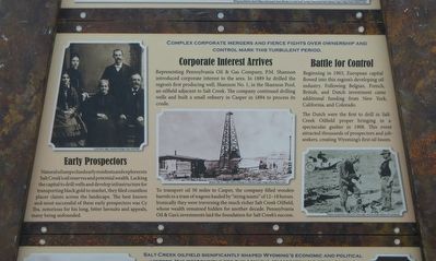
In the early 1900s, hopeful oil workers flooded Salt Creek - especially "boomers" from "gone bust" oilfields in other states. Many companies built camps next to wells to house employees. As companies changed hands and shifted . . . — — Map (db m91659) HM
In 1874, the U.S. Army discovered gold in the Black Hills of South Dakota. The resulting gold rush required a stage line that could carry gold from the remote mining town of Deadwood, Dakota Territory, to Cheyenne, a commercial center on the Union . . . — — Map (db m98260) HM
The Dreaded Crossing.
Along the Cheyenne-Deadwood stage route, stories still are told of outlaws and buried gold. Bandits haunted the Cheyenne-Deadwood Stage line during the gold boom that began in Deadwood in 1876. By the end of 1877, gold . . . — — Map (db m98257) HM
The Cheyenne River drainage system has been the locus of human activity for thousands of years. Native Americans used the corridor in search of wild game and wild plants resources. When gold was discovered in the Black Hills in 1875, miners, . . . — — Map (db m98259) HM
In Memory of
George Lathrop
Pioneer of the West, Indian fighter, veteran stage driver.
Born at Pottsville, Pa. Dec. 24, 1830
Died at Willow, Wyo. Dec. 24, 1915 Buried here
"A good man whose life was filled with striving . . . — — Map (db m98299) HM
Here lies Mother Featherlegs Shepard. So called, as in her ruffled pantalettes she looked like a feather-legged chicken in a high wind. She was a road house ma'am. An outlaw confederate, she was murdered by "Dangerous Dick Davis The Terrapin" in . . . — — Map (db m98303) HM
By the standards of the petroleum industry, the C & H Refinery is tiny, but placed in the light of history, that small enterprise illustrates the enormous transformation of the oil business. In the late nineteenth century, a multitude of small oil . . . — — Map (db m119960) HM
The Lusk House is one of the oldest buildings and was the first brick home built in Lusk. Founder of the town, Frank S. Lusk, built the home in 1886 for his mother, Cornelia Lusk, and her mother, Sarah Stillman. The Lusk family founded and helped . . . — — Map (db m242196) HM
Balanced Plunger Hydraulic Valve
This 48-inch diameter valve is one of two which were originally installed at the base of the Buffalo Bill Dam in 1922 to supply water to the Shoshone Powerplant and low level river outlet works. The two valves were . . . — — Map (db m104003) HM
Ball Plug
This large wood and concrete ball plug was one of two used to halt the flow of water through the 42-inch diameter power outlet works conduits, located in the base of the dam. The balls facilitated the repair and maintenance of downstream . . . — — Map (db m104004) HM
This monument, erected by the Brotherhood of the American Mountain Men, is "dedicated to all Mountain Men known and unknown for their essential part in the opening of the American West." It consists of two busts and six plaques honoring four . . . — — Map (db m91017) HM
Young Buffalo Bill Cody started his famous career with the great freighting firm of Russell, Majors and Waddell as a messenger boy. He became a spectacular Pony Express rider with the same firm and road between Red Buttes and Three Crossings, along . . . — — Map (db m91008) HM
Upstream Cableway Winch
This cableway winch, which was used to install and remove the ball plugs, trash racks, and the bulkhead gate for the left abutment outlet works, dates to the construction of the Shoshone Powerplant in 1922. It was . . . — — Map (db m104002) HM
The agriculture producers of the Big Horn Basin invite you to enjoy our majestic mountains, pristine streams, and lush meadows. These meadows aren’t here for aesthetics; man has strived to irrigate this dry rocky land to make his cows . . . — — Map (db m88968) HM
This valley has sustained life for thousands of years. Early Native Americans were drawn here to hunt buffalo, elk, deer, moose, sheep and bear. It has always been considered a unique place. The establishment of the nation’s first park and . . . — — Map (db m89027) HM
During the 1850s and 1860s, wagon freighters fed and watered mules and oxen, exchanged tired stagecoach horses for fresh ones, and conducted other tasks at the historic Horseshoe Creek Station near here. A nearly endless stream of emigrants from the . . . — — Map (db m92129) HM
This sight points to the Guernsey Pipeline Station, jointly owned by the Platte Pipeline Company, the American Oil Company and the Continental Oil Company. Most of the structures under view were built in 1952 although, owing to the river’s . . . — — Map (db m86954) HM
North Platte River: Gateway Corridor
Currents of History Travel Alongside the North Platte River
Routes along the river originally used by Native Americans were later adopted by fur traders. Beginning as a trickle, . . . — — Map (db m164747) HM
In Honor of
Jacques La Ramie
Free trapper,
who came to this region around 1815
and met an unknown fate,
probably at the hands of Indians,
about 1820, on one of
the rivers bearing his name
between which this . . . — — Map (db m92131) HM
Big Horn grew up as one of the main communities along the stage route in Sheridan County. The first Big Horn Post Office was established in 1879 at Thomas Creighton's ranch two miles northeast of Big Horn. In 1881, Creighton sold his ranch, and the . . . — — Map (db m91401) HM
Near here emigrants traversed the Bozeman Trail, 1864-68 to Virginia City, Montana gold mines. Confronted with hostile Indians unwilling to share their hunting grounds, the trail became known as the "Bloody Bozeman" and was discontinued. . . . — — Map (db m91423) HM
You are Standing Near Acme
(the former Acme townsite was located southeast of the existing power plant structure.)
In 1907, A.K. "Archie" Craig and Ora Darnell created the Acme Coal Company. By 1911, the company had opened Acme 1 . . . — — Map (db m189698) HM
Immigrants working in the mines shaped Sheridan County's rich cultural identity Although the majority of immigrants came from Poland, over 20 nationalities were represented in the Sheridan County mines. Many Polish food dishes, drinks, and . . . — — Map (db m189688) HM
You Are Standing Near Carneyville/Kleenburn
The Carney Coal Company opened the Carney Mine in 1904 and established the company town of Carneyvlle. The town, described as neat and in excellent repair, boasted that it was never the point of . . . — — Map (db m189695) HM
Stretching north from Sheridan for about 15 miles, the Black Diamond Trail highlights Sheridan County mining districts that were integral to the settlement and development of the city and county of Sheridan. Although the peak of activity was the . . . — — Map (db m91450) HM
Stretching north from Sheridan for about 15 miles, the Black Diamond Trail highlights Sheridan County mining districts that were integral to the settlement and development of the city and county of Sheridan. Although the peak of activity was the . . . — — Map (db m189700) HM
What Began with "Wagon Mines" ...
Ranches in Sheridan County accessed outcrops of coal with pick and shovel as early as 1880. Known as "wagon mines" because people loaded the coal directly into wagons, these mines served the local . . . — — Map (db m91454) HM
You are Standing Near Kooi
Peter Kooi (pronounced "Coy) established the Kooi Mine in 1906, making it the only area coal mine established by an individual and not a company. Soon after, he organized a modern mining camp, where he promoted . . . — — Map (db m189704) HM
Welcome to Monarch
Mr. Stotts and Mr. Edleman founded the Monarch Mine in 1903, and L.H. Brooks, William C. Ervine, and J.B. Kendrick, future Wyoming U.S. senator and governor, later consolidated it. Mining began to decline in the early . . . — — Map (db m189689) HM
You are standing just north of the route taken by thousands of people, cattle and horses migrating west on the Lander Cut-off, the northern fork of the Oregon Trail, starting in 1858. None settled here then. By the late 1870s, cattle from the west . . . — — Map (db m85813) HM
This maker consists of three plaques, each dealing with the Lander Cut-off.
“The Best Mountain Road in the West”
In 1857, Congress funded construction of the Fort Kearney-South Pass-Honey Lakes Wagon Road (Lander . . . — — Map (db m80540) HM
Because timber was scarce in neighboring states along the first transcontinental railroad line, the tie business flourished here and in other Wyoming mountain locations. Ties were cut in winter, stored on the river bank until spring, and floated . . . — — Map (db m80522) HM
In May of 1832, Captain Benjamin Bonneville left Fort Osage, Missouri with an expedition consisting of one hundred and ten men and twenty wagons, headed for the Rocky Mountain West. Upon his arrival in the Green River Valley, he ordered immediate . . . — — Map (db m80521) HM
From the first big beaver season in 1824 to the last Rendezvous in 1840, the Green River Valley was the center of the Rocky Mountain fur trade. Six of the 16 summer Rendezvous (1833, 1835, 1836, 1837, 1839, 1840) were held here at the confluence of . . . — — Map (db m80517) HM
Buried on Fontenelle Creek, exhumed 1897, taken to the U.S.Circuit Court at St. Louis, Mo., returned by a court order to Sublette County, Wyoming to be buried here July 27, 1935.
Placed
July 4, 1936
The Historical Landmark Commission
of . . . — — Map (db m80513) HM
On Oct. 16, 1812, the Astorians (Robert Stuart, Ramsay Crooks, Robert McClellan, Joseph Miller, Benjamin Jones, Francis Eclair and Andy Vallee) passed this way and forded Pine Creek near here, the first white men known to have seen it. They were . . . — — Map (db m90931) HM
The river below is the Green. The mountains to the west are the Wyomings (Bear Rivers). Those to the the east, the Windrivers. Along the river banks below are the Rendezvous sites of 1833, 1835 (New Fork), 1836, 1837 (Cottonwood), 1839, 1840 and . . . — — Map (db m208244) HM
(Two panels make up this marker)
Hundreds of trappers and traders and thousands of Indians met on the banks of the Green River in front of you for the rendezvous of 1833, 1835, 1836, 1837, 1839, and 1840 to exchange a year's worth of . . . — — Map (db m180108) HM
has been designated a
Registered National
Historic Landmark
under the provisions of the
historic sites act of August 21, 1935
This site possesses exceptional value
in commemorating and illustrating
the history of the United . . . — — Map (db m180104) HM
The bed of prehistoric Lake Gosiute (Go-shute) lies hundred of feet below you. This ancient lake set the stage of the world's largest trona and oil shale deposits as well as a significant natural gas reserve.
Lake Gosiute Creates Trona . . . — — Map (db m90093) HM
The Green River has long been a workplace for several major industries, providing jobs to many people in the area. Harvest of railroad ties was one of the first to develop. From 1868 to 1945, spring runoff signaled the arrival of the ties and tie . . . — — Map (db m90038) HM
Where sodium carbonate brine was discovered in 1896, which was the fore-runner of the present sodium chemical industry in this area. — — Map (db m90059) HM
For the first 100 years of its history, Green River's population fluctuated between 2,000 and 4,000 people. Townspeople lived north of the Green River, staggered on both the north and south sides of the railroad tracks. In the 1970s, an increase in . . . — — Map (db m90068) HM
Just prior to World War II, the Union Pacific Railroad verified the existence of trona and the immense size of the trona patch through core drilling across its vast land holdings. Prior to development of the trona industry in the 1940s and 1950s, . . . — — Map (db m90058) HM
"When all had come in, he (Ashley) opened his goods, and there was a general jubilee.... We constituted quite a little town, numbering at least eight hundred souls, ...half were women and children. There were some ... who had not seen any groceries, . . . — — Map (db m90098) HM
It was in 1910 that coal mine operations began at Reliance. These mines were operated by the coal mining company of the Union Pacific Railroad. Here, where the tipple now stands, the first coal loading facility was constructed in 1912. The stone . . . — — Map (db m89721) HM
The tipples constructed here were designed to serve all the Reliance coal mines. Union Pacific Coal Company opened their mines in phases. The coal mines were all located east of here with portals located along the sides of the valley. Coal from . . . — — Map (db m89752) HM
From 1910 to 1955, the mines at Reliance produced coal for the Union Pacific Railroad. To staff these mines, people from a variety of countries were hired. During World War II there were not enough mine workers to extract the coal. People were . . . — — Map (db m89753) HM
Beneath This Monument
Coal Was First Mined
In This District
Site Of
Union Pacific No. 1 Mine
A.D. 1868
Erected September 17, 1938 — — Map (db m67813) HM
The basic oil derrick has an upright stationary section which is capable of supporting hundreds of tons of weight, combined with a movable boom which is used to raise and lower equipment. Derricks of various designs have been in use for centuries to . . . — — Map (db m156597) HM
Buried under the streets of Rock Springs are seams of coal. In 1850 Howard Stansbury noted that coal could be found near the present town. When, in 1868, the Union Pacific Railroad built through the area, the large commercial mines opened. Number 1 . . . — — Map (db m67812) HM
On June 6, 1929, the Rock Springs Coal "Welcome" sign was lit. The Union Pacific Coal Company Employes' Magazine reported it spanned the Lincoln Highway and was approximately 100 feet from the main line of the Union Pacific Railroad. It was . . . — — Map (db m67811) HM
Prospecting revealed that Seams Nos. 3, 1, 7, and 13, the latter also known as the Van Dyke Seam, were of sufficient thickness to justify the development of mines. Preliminary railroad surveys were made up the long canyon from Thayer Junction on the . . . — — Map (db m92213) HM
In 1900, while prospecting was being carried on in the vicinity of Cumberland, Morgan Griffiths, Gus Paulsen and a party of prospectors went northeast from Rock Springs to prospect in Horse Thief Canyon, since outcrops of a promising deposit of coal . . . — — Map (db m92216) HM
This monument is dedicated to the miners who worked here and especially to those who lost their lives. It is also a monument to the living -- those who ave remained and exemplify the men and women whose independent character created this community. . . . — — Map (db m92235) HM
Men and machines became the rule within the Superior Coal Field. While mules and horses were used in the early years, by the late 1930's, most of the mines had mechanized loaders, conveyors, and cutters. The cutters under-cut the coal, the loaders . . . — — Map (db m92211) HM
was organized by Robert Miller in 1914 and was located on Crabtree Corner. Most of the initial capital of $10,000 was subscribed to by local citizens. Mr. Miller's nickname was "Old Twelve Percent" due to the high interest rate he charged.Next door . . . — — Map (db m47071) HM
The log cabin to the far left once housed the Jackson Post Office. Next door stood the I.O.O.F. (Independent Order of Odd Fellows) building, which is still recognizable today.In the distant background there is the distinctive curved roof line of the . . . — — Map (db m47074) HM
In the late 1920s, Harrison Crandall built this cabin to house his studio. Crandall documented the romantic and humorous side of “dudes” – a nickname given to early visitors. He sold hundreds of postcards and prints from this . . . — — Map (db m88290) HM
Nineteenth Century railroads were dependent upon coal for fuel. The vast coal reserves of southern Wyoming helped determine the route of the transcontinental Union Pacific Railroad and were the basis for Wyoming's first energy boom. . . . — — Map (db m36537) HM
Several plaques are located at this kiosk
Hilliard City and Piedmont
Early settlers began to arrive on "Hilliard Flats" in 1860 to ranch and grow crops. Long, cold winters and short growing seasons made it difficult to . . . — — Map (db m90438) HM
This set of buildings completed the holdings of the Post Trader. The first board and batten building with the large double doors served as the carriage house. Judge Carter owned several animal-drawn vehicles which lent an air of wealth to the . . . — — Map (db m90748) HM
At the close of the fur trade era, western America history began to take on a more permanent shape. The motivation of people coming west shifted away from exploration and hunting. Families were seeking land to clear and farm; men were hoping to find . . . — — Map (db m90618) HM
At the northeast corner of Judge Carter's complex rose the log chinked ice house. Three doors at the southern side appeared one over the other, allowing this tall building of 18 feet 7 inches by 14 1/4 feet to be entered at all levels as the ice . . . — — Map (db m90731) HM
1804-1881
Famous mountain man, trader and scout Donated by the Fort Bridger Historical Association Dedicated 8-8-08
Artist David A. Clark — — Map (db m13650) HM
The fort was established about 1842 by Jim Bridger discoverer of Great Salt Lake; notable pioneer, trapper, fur trader, scout and guide. Bridger was born at Richmond, Virginia, March 17, 1804 and died at Westport, Missouri, July 17, 1881. His . . . — — Map (db m36596) HM
The buildings in this area are virtually all that remain of the once thriving commercial empire of Judge William Alexander Carter and his wife Mary, Fort Bridger's only two Post Traders. Carter arrived at Fort Bridger with Colonel Albert S. . . . — — Map (db m90724) HM
Although Judge Carter dabbled in many areas, his main responsibility revolved around his activities as the post trader at Fort Bridger. In this store he sold various items not supplied by the Army to the garrison, including limited amounts of . . . — — Map (db m90727) HM
Four panels are located at the kiosk
Town of Piedmont
Located west of the kilns, the town of Piedmont started out as a logging camp supplying ties for the approaching Union Pacific Railroad in the 1860s. It also served as . . . — — Map (db m90444) HM
The Hanover Canal System, an irrigation project funded by J.W. Pulliam and his family, was completed in the Big Horn Basin in 1905, bringing settlers to Worland. Soon after the close of the project, which included the Big Horn Canal, Pulliam planted . . . — — Map (db m97828) HM
In February of 1966, Al Smith of Newcastle made history by successfully completing the world's only producing hand dug oil well. Using a pick and shovel, he dug twenty-one feet into the oil-bering Newcastle Formation. When he encountered the harder . . . — — Map (db m98224) HM
Located 7 miles north of Newcastle was the coal mining town of Cambria. In 1887, Frank Mondell, a future Congressman, found enough coal in the area to fuel the construction of the Chicago, Burlington and Quincy Railroad across northeastern Wyoming. . . . — — Map (db m98172) HM
Coal Determines the Route
The 1888 discovery of coal at Cambria, eight miles north of Newcastle, provided the final key to railroad development through the northeast Wyoming Territory. The main line of the railroad stretched west from . . . — — Map (db m98219) HM
A group of Euro-Americans discovered salt springs in July, 1877 near the future town sites of Newcastle and Cambria. In November of 1878, James LeGraves started mining the salt and shipping it to the Black Hills gold mines. LeGraves erected a . . . — — Map (db m98169) HM
Following the Civil War, construction of the transcontinental Railroad opened the West, ensuring elimination of vast buffalo herds and forcing Native American Indians onto reservations where the military provided food.
Leggy Texas Longhorns were . . . — — Map (db m98249) HM
Newcastle Becomes a Center
Development of northeastern Wyoming came quickly on the heels of the Chicago, Burlington and Quincy Railroad, or the Burlington Northern and Santa Fe as it is known today. The Burlington's Grand Island and Northern . . . — — Map (db m98217) HM
The Osage Oilfield was the first large producing oil field in Weston County. The first oil well drilled here and put into commercial production was the discovery well drilled by the Sinclair Oil Company in 1919. It was immediately sold to Alliance . . . — — Map (db m98246) HM
Following the Civil War, construction of the transcontinental Railroad opened the west, ensuring elimination of the buffalo herds, forcing Native American Indians onto reservations where the military provided food. The rails transported range . . . — — Map (db m98248) HM
184 entries matched your criteria. Entries 101 through 184 are listed above. ⊲ Previous 100