By J. J. Prats, June 13, 2019
Manchester Founders Cemetery side or marker
GEOGRAPHIC SORT Title Sort Marker Number Sort Marker Number Sort N Marker Number Sort T Publication Order Sort Publication Order Sort A Erected Year Sort Most Viewed Sort Most Recent-Interest Sort Most Recently Changed Sort SEE FAQ #33 FOR DESCRIPTIONS
On 2nd Street (U.S. 52) west of Jack Roush Way, on the right when traveling west. Reported missing.
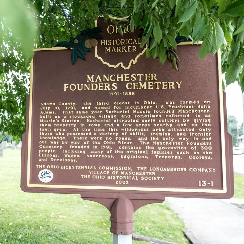
Near East 8th Street, 0.2 miles east of Cemetery Street, on the right when traveling east.
Near East 8th Street, 0.2 miles east of Cemetery Street, on the right when traveling east.
Near Horner Chapel Road (Ohio Route 73) 0.9 miles west of Horner Chapel Road (County Road T-116), on the right when traveling west.
Near Ohio Route 73, 0.9 miles west of Horner Chapel Road (County Road T-116), on the right when traveling west.
Near Ohio Route 73, 0.9 miles west of Horner Chapel Road (County Road T-116), on the right when traveling west.
Near South Cherry Street south of West South Street, on the right when traveling south.
On North Pevee Road, on the right when traveling north.
Near West Main Street west of South Greenlawn Avenue, on the left when traveling west.
On West Hume Road, 0.5 miles west of Shawnee Road.
On Sandy Point Road, 0.3 miles north of Lincoln Highway, on the right when traveling north.
On Eastown Road, on the left when traveling north.
On Central Avenue, on the right when traveling north.
On Bluelick Road, 0.1 miles west of Sugar Street, on the right when traveling west.
On Defiance Trail, on the right when traveling north. Reported missing.
Paid Advertisement
Near South Ridge Road (Ohio Route 84) at County Line Road.
Near West State Street, 0.1 miles west of North Lancaster Street, on the right when traveling west.
Near West State Street, 0.1 miles west of North Lancaster Street, on the right when traveling west.
Near West Bailey Road, 0.1 miles west of Converse Street (Ohio Route 13), on the left when traveling west.
On West Washington Street at Fort Street, on the left when traveling east on West Washington Street.
On Fort Street, 0.5 miles south of Clinton Street, on the left when traveling north.
On Fort Street, 0.5 miles Clinton Street, on the left when traveling north.
On Old Main Street Road, on the left when traveling east.
On Cemetery Road (County Road 161) north of Santa Fe-New Knoxville Road (County Road 100), on the right when traveling north.
On Ohio Route 198, 0.2 miles south of Deep Cut Road (Local Highway 230), on the right when traveling north.
On Ohio Route 198, 0.2 miles south of Deep Cut Road (Local Highway 230), on the right when traveling north.
On Ohio Route 198, 0.2 miles south of Deep Cut Road (Local Highway 230), on the right when traveling north.
On Ohio Route 198 south of Deep Cut Road (Local Highway 230), on the right when traveling north.
On Ohio Route 198, 0.2 miles south of Deep Cut Road (Local Highway 230), on the right when traveling north.
Near East 1st Street, on the right when traveling east.
On South St. Marys Street north of West German Street, on the right when traveling south.
Paid Advertisement
On South West Street south of West German Street, on the right when traveling north.
On Center Street west of Walnut Street, on the left when traveling west.
On U.S. 33 at Ohio Route 65, on the left when traveling east on U.S. 33.
Near East Greenville Road, 0.3 miles east of South Main Street (Ohio Route 66), on the right when traveling west.
On Greenville Road at South Ash Street, on the right when traveling east on Greenville Road.
On Oakes Place, 0.2 miles Flat Rock Road, on the right when traveling south.
On Church Street at Greenbank Avenue, on the left when traveling north on Church Street.
On Negus Road (County Route 456), on the right when traveling west.
On Negus Road (County Route 456), on the right when traveling west.
On North 4th Street, 0.1 miles north of Ellet Street, in the median.
On 4th Street, on the right when traveling north.
On 4th Street, on the right when traveling north.
On 4th Street, on the right when traveling north.
On Newell Avenue east of North Market Street, on the left when traveling east.
Near Maple Avenue (Ohio Route 9) north of Bett-Mar Lane, on the right when traveling north.
On Newell Avenue (U.S. 9) east of North Butler Avenue, on the right when traveling north.
Paid Advertisement
On Anderson State Road (U.S. 50), on the right when traveling south.
On Seward Road at Dixie Hwy (Ohio Route 4), on the left when traveling south on Seward Road.
On River Road at Lakeside Drive, on the right when traveling north on River Road.
On South Third Street near Charles Str, on the left when traveling south.
On South Third Street, on the left when traveling south.
On Elk Creek Road at Howe Road, on the right when traveling north on Elk Creek Road.
On Reily-Millville Road (County Route 29) 0.2 miles west of Bunker Hill Woods Road, on the right when traveling east.
On Indian Creek Road (County Route 37), on the left when traveling east.
Near Indian Creek Road, 0.7 miles north of Imhoff Road, on the right when traveling north.
Near Oxford Millville Road (U.S. 27) 0.3 miles north of Stillwell Beckett Road, on the right when traveling north.
On Brown Road, 0.2 miles south of Doty Road, on the right when traveling south.
On East Chestnut Street, on the left when traveling west.
On Cincinnati-Brookville Road (Ohio Route 126), on the right when traveling east.
On State Street (Ohio Route 73) at Miami Street / Hamilton Road, on the left when traveling west on State Street.
Paid Advertisement
Near Stevenson Road (County Route 11).
On Inskeep Road (County Route 144) at Clay Street, on the left when traveling north on Inskeep Road.
On Ohio Route 245, 0.2 miles south of Mt. Tabor Road (Ohio Route 507), on the right when traveling north.
On Sandusky Street (Ohio Route 4), on the right when traveling east.
On W, Elm Street (County Route 111) near Winder St, on the right when traveling east.
Near Cemetery Lane east of Patrick Avenue (Ohio Route 54), on the left when traveling east.
On Patrik Avenue (Ohio Route 54) 0.1 miles south of Jefferson Avenue, on the left when traveling south.
On Kennard- Kings Creek Road (County Route 130) at East Kings Creek Road (County Route 125), on the left when traveling north on Kennard- Kings Creek Road.
On North Main Street (U.S. 68) at Fyffe Street, on the left when traveling north on North Main Street.
On Scioto Street east of North Main Street (U.S. 68), on the right when traveling west.
On KentonStreet at Ward Street, on the right when traveling north on KentonStreet.
On U.S. 36, 0.2 miles west of Ohio Route 560, on the left when traveling east.
On Urbana Woodstock Pike (County Route 2) 0.5 miles west of Main Street (Ohio Route 559).
On Urbana Woodstock Road (County Route 2) 0.4 miles west of Main Street (Ohio Route 559), on the right when traveling west.
On Indian Drive at Mound Circle, in the median on Indian Drive.
Near Dayton-Springfield Road at Winding Drive.
Paid Advertisement
Near West Columbia Street (U.S. 40) just east of North Wittenberg Avenue, on the left when traveling east.
On West Columbia Street (U.S. 40) 0.1 miles east of North Wittenberg Avenue, on the right when traveling east.
Near West McCreight Avenue (Ohio Route 41) near St Paris Pike, on the left when traveling west.
On North Hampton Road, 0.3 miles north of Troy Road (Ohio Route 41), on the left when traveling north.
On Elklick Road, on the left when traveling east.
Paid Advertisement
On Old Bullskin Trail (Ohio Route 133) at West Circus Street, on the left when traveling north on Old Bullskin Trail.
On Ohio Scenic River Byway (U.S. 52) 0.1 miles east of Woods Hill, on the left when traveling east.
On Mount Moriah Drive, on the left when traveling east.
On Ohio Route 727, 0.4 miles east of Ohio Route 133, on the right when traveling east. Reported missing.
On Glendale Milford Road (Ohio Route 126) at Center Street, on the right when traveling west on Glendale Milford Road.
523 entries matched your criteria. The first 100 are listed above.
Next 100 ⊳