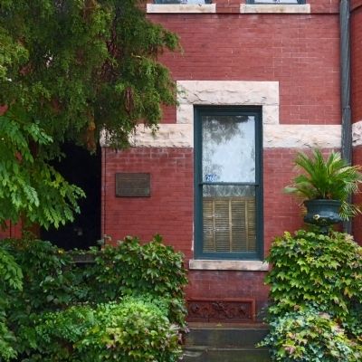
Near Maryland Avenue Northeast (Alternate U.S. 1) at 3rd Street Northeast.
This residence was designed by architect Appleton P. Clark, Jr. and built in 1891 for Daniel Birtwell. In 1900, George Bruce Cortelyou occupied the house when he became secretary to President McKinley. Cortelyou continued to serve in public office . . . — — Map (db m69292) HM
On East Capitol Street Northeast at 12th Street Northeast, in the median on East Capitol Street Northeast.
In grateful memory of Abraham Lincoln. This monument was erected by the Western Sanitary Commission of Saint Louis, Mo., with funds contributed solely by emancipated Citizens of the United States declared free by his Proclamation, January 1st . . . — — Map (db m41617) HM
On East Capitol Street Southeast west of 22nd Street Southeast, on the right when traveling east.
The F-16 became the D.C. Air National Guard alert duty aircraft on Sept. 11, 2001. For twelve years, this capable fighter has responded to more than 4,000 individual alert missions over the District of Columbia. The U.S. Air Force has flown the . . . — — Map (db m74097) HM WM
On East Capitol Street Southeast just west of 22nd Street Southeast, on the right when traveling east.
The F-16 became the D.C. Air National Guard alert duty aircraft on Sept. 11, 2001. For twelve years, this capable fighter has responded to more than 4,000 individual alert missions over the District of Columbia. The U.S. Air Force has flown the . . . — — Map (db m213155) HM
Near E Street Southeast at Potomac Avenue Southeast, on the right when traveling south.
Ann G. Sprigg ran a boarding house, where Abraham Lincoln lived during his time as a U.S. Representative from Illinois (March 4th 1847 to March 3rd, 1849), at the present-day site of the Library of Congress Jefferson Building. The Sprigg . . . — — Map (db m211910) HM
On E Street Southeast at Potomac Avenue Southeast, on the right when traveling east on E Street Southeast.
For Anna & Frederick Douglass, their work, home, & life centered on abolition, & fair treatment & respect for African Americans.
Anna met Frederick, an enslaved 17-year-old in 1838. They fell in love; she encouraged, & financed his flight . . . — — Map (db m211913) HM
Near 17th Street Southeast at G Street Southeast, on the right when traveling north.
Barney Circle honors U.S. Navy Commodore Joshua Barney. In August 1814, Barney, his Chesapeake Flotillamen, and a contingent of U.S. Marines guarded a bridge over the Eastern Branch (Anacostia River) on today's Bladensburg Road, NE. When it became . . . — — Map (db m80473) HM
Near E Street Southeast east of Potomac Avenue Southeast, on the right when traveling east.
General Peterson Goodwyn equipped his own company and was cited for gallantry at the battles of Smithfield and Great Bridge — member of the Virginia House of Delegates 1789 – 1802, elected as a Democrat to the eighth and seven succeeding Congresses . . . — — Map (db m80692) HM
Near Potomac Avenue Southeast at E Street Southeasr, on the right when traveling east.
Civil War Washington City
Over the course of the Civil War, the nation's capital was transformed. The dignified government city Pierre Charles L' Enfant laid out in 1791 was hardened into a sprawling military center. Encircled by strong . . . — — Map (db m139512) HM
Near E Street Southeast, 0.1 miles east of Potomac Avenue Southeast, on the right when traveling east.
Elbridge Gerry was a 1762 graduate of Harvard and a signer of the Declaration of Independence and Vice President of the United States. Gerry served as a representative from Massachusetts to the First Continental Congress, and on July 4, 1776, he . . . — — Map (db m141885) HM
Near E Street Southeast at Potomac Avenue Southeast, on the right when traveling east.
Erected by the Board of Trustees of Fourth Street M.E. Church July 1, 1893, in memory of the dead removed from the old Methodist Burial Ground, formerly called "Our [unreadable] Well"
"Blessed are the dead which die in the Lord . . . — — Map (db m211920) HM
Near E Street Southeast at Potomac Avenue Southeast, on the right when traveling east.
Established in 1836 by hotelier John Gadsby, this structure was built to house many members of his family. An immigrant from England, Gadsby started his career in Alexandria in 1795. His reputation for fine hospitality was sealed at the City . . . — — Map (db m211921) HM
On E Street Southeast just east of Potomac Avenue Southeast, on the left when traveling east.
Congressional Cemetery, founded 1807, is the resting ground for many War of 1812 figures. Among them are Navy Yard Commandant Thomas Tingey, the first architect of the Capitol, Dr. William Thornton, State Department Clerk Stephen Pleasonton, and . . . — — Map (db m80481) HM
Near 17th Street Southeast south of G Street Southeast, on the right when traveling north.
John Philip Sousa (1854–1932), known as the “March King,” grew up in Washington on G Street SE, between 6th and 7th. Sousa became a leader of the Marine Band in 1880 and served in this position for 12 years, leading band tours . . . — — Map (db m82268) HM
Near E Street Southeast, 0.1 miles east of Potomac Avenue Southeast, on the right when traveling east.
Patriot John Smilie (1741-1812) joined the militia when the Revolutionary War began, leaving his Pennsylvania farm in the care of his wife. He was elected to the Pennsylvania state legislature in 1784. A vocal abolitionist, Smilie was instrumental . . . — — Map (db m141886) HM
Near E Street Southeast at Potomac Avenue Southeast, on the right when traveling east.
Filmmakers Lee Shapiro and Jim Leindelof spent six months inside Afghanistan traveling with the mujahidin documenting the plight of the Afghan people under Soviet occupation.
On Oct. 9, 1987, they were ambushed and killed outside Kabul. . . . — — Map (db m211912) HM
Near E Street Southeast, 0.2 miles east of Potomac Avenue Southeast, on the right when traveling east.
Never Again
6 July 1943
Never Forget
22 June 1988
A Gay Vietnam Veteran
When I was in the military
they gave me a medal for killing two men
and a discharge for loving one.
[Presidential plaque on grave . . . — — Map (db m141894) WM
Near E Street Southeast at Potomac Avenue Southeast.
Mathew Brady (1822-1895) is considered by some to be the father of photojournalism, thanks to his photos of the Civil War. His exhibit "The Dead of Antietam" showed photos of corpses and was the first time many had seen the realities of war in . . . — — Map (db m211915) HM
Near E Street Southeast just east of Potomac Avenue Southeast, on the right when traveling east.
Historic Congressional Cemetery is the final resting place of four significant contributors to the Underground Railroad.
William Boyd •
John Dean •
David A. Hall •
Hannibal Hamlin — — Map (db m141883) HM
Near E Street SE at Potomac Avenue SE, on the right when traveling east.
Choctaw Chief—Diplomat—Education Leader
Born January 30, 1896
Died January 17, 1881
• Principal Chief, Choctaw Nation of Oklahoma 1864-1866
• Tribal Commissioner for land claims against the U.S. Government
(1853-61 — . . . — — Map (db m139480) HM
Near E Street Southeast, 0.1 miles east of Potomac Avenue Southeast, on the right when traveling east.
Brigadier General Pushmataha (1764-1824) was a Choctaw chief, warrior, hunter, and great friend of many, including President Andrew Jackson. In 1812, Pushmataha led 1,000 warriors of Choctaw Nation to fight alongside Jackson at the Battle of New . . . — — Map (db m141889) HM
On M Street Southeast east of Water Street Southeast, on the right when traveling east.
The Seafarers Yacht Club is the oldest African American boat club on the East Coast. It was founded in 1945 by Lewis T. Green, Sr., a vocational arts teacher in the DC Public Schools who built boats as a hobby. Needing a dock, he contacted the U.S. . . . — — Map (db m89445) HM
Near E Street Southeast at Potomac Avenue Southeast, on the right when traveling east.
The totem pole you see here was carved by the Lummi Nation of Washington State in remembrance of those that lost their lives during the tragic events of the terrorist attacks on September 11, 2001. Located along the Ward Six 9-11 memorial path, . . . — — Map (db m211918) HM WM
Near E Street Southeast at Potomac Avenue Southeast, on the right when traveling east.
This path is the official Ward 6, September 11, 2001 Memorial honoring and remembering those who lost their lives during the terrorist attacks in New York City, Washington, DC, and Pennsylvania. It was designed to be a sensory experience to . . . — — Map (db m211917) WM
Near E Street Southeast at Potomac Avenue Southeast, on the right when traveling east.
Mathew Brady was one of the most outstanding early photographers in American history, with his work from 1844 to 1895. He is credited today as the father of photojournalism. This memorial was erected to honor him & his photography, as well his . . . — — Map (db m211914) HM
Near E Street Southeast at Potomac Avenue Southeast, on the right when traveling east.
- Built by Congress in 1835 at a cost of $5,000.
- Used as a temporary receiving vault for bodies to be interred here or elsewhere at a later date.
- No charge for members of Congress, but $5 per month for private citizens.
- The . . . — — Map (db m211922) HM
Near 17th Street Southeast at H Street Northeast, on the right when traveling north. Reported permanently removed.
Peace – War
[Rendering of the Healing Totem Poles]
Liberty - Freedom
Sovereignty
The cross piece at the top carries two eagles: Peace, a female, faces east; War, a male, faces west. The eagles are symbols of courage and . . . — — Map (db m39960) HM
Near E Street Southeast, 0.1 miles east of Potomac Avenue Southeast, on the right when traveling east.
On the “cold, damp” day of Friday, January 30, 1835 President Andrew Jackson and other dignitaries attended a memorial service in the Capitol Rotunda for the recently deceased South Carolina Congressman Warren R. Davis. As the crows departed at the . . . — — Map (db m141888) HM
Near 17th Street Southeast at G Street Southeast, on the right when traveling north.
Dedicated to the Memory of the Victims of the U.S. Arsenal Explosion on June 17, 1864
Ellen Roche •
Julia McEwen •
Bridget Dunn •
W. E. Tippett •
Margaret Horan •
Johanna Connors •
Susan Harris
Lizzie Brahler •
Margaret . . . — — Map (db m80961) HM WM
Near E Street Southeast at Potomac Avenue Southeast, on the right when traveling east.
Killed by an explosion at the U.S. Arsenal Washington D.C. June 17th 1864
Ellene Roche •
Julia McEwen •
Bridget Dunn •
W.E. Tippett •
Margaret Horan •
Johanna Connors •
Susan Harris •
Lizzie Brahler •
Margaret C. Yonson • . . . — — Map (db m211916) HM WM
On East Capitol Street Southeast east of 19th Street Southeast, on the right when traveling east.
The venerable UH-I “HUEY” helicopter was a beloved work horse for the District of Columbia Army National Guard, safely and reliably supporting the Nation’s Capital for over 40 years. With 2-4 crew members, HUEYs carried up to 6 litter patients . . . — — Map (db m73785) HM WM
Near E Street Southeast, 0.1 miles east of Potomac Avenue Southeast, on the right when traveling east.
Uriah Tracy (1755-1807) was a Revolutionary War patriot and later a Senator from Connecticut. As a young man, he joined a militia company that responded to the famous Lexington Alarm in 1775. Tracy studied law at Yale & served in the Connecticut . . . — — Map (db m141895) HM
On E Street Southeast just east of Potomac Avenue Southeast, on the right when traveling east.
Welcome to Congressional Cemetery, a place where American heritage comes to life every day.
There are about 65,000 people buried on these 35 acres, and about half of them are children. Historic Congressional Cemetery predates Arlington . . . — — Map (db m141882) HM
On 7th Street Southeast just south of Virginia Avenue Southeast, on the right when traveling south.
The Marine Barracks Annex was established August 23, 2004, and is home to "The President's Own" United States Marine Band. Founded by an Act of Congress in 1798, the Marine Band is the oldest continuously professional musical organization in the . . . — — Map (db m210267) HM
On South Carolina Avenue Southeast just east of 6th Street Southeast, on the right when traveling east.
Since 1936 Friendship House, across the street, has operated an array of social service programs from this grand Federal style house, also known as "The Maples." Friendship House is the city's oldest such agency. It was founded in 1904 by . . . — — Map (db m166999) HM
On Eighth Street Southeast at G Street Southeast, on the right when traveling north on Eighth Street Southeast.
The buildings near this corner were built during a wave of private development that began after the United States won the Spanish-American War in 1898, and became a world power for the first time. As America flexed its muscles, the world — . . . — — Map (db m130725) HM
On D Street Southeast west of 3rd Street Southeast, on the right when traveling west.
Chartered 1922
In memory of all members of
the Armed Forces who served their country
American Legion Post 8
Sons of the American Legion Squadron 8
American Legion Auxiliary — — Map (db m116123) WM
On 8th Street Southeast at Pennsylvania Avenue Southeast, on the left when traveling south on 8th Street Southeast.
The large building that wraps around this corner was constructed as a department store in 1892 by Elizabeth A. Haines. She proudly advertised it as "the largest store in the world, built, owned and controlled by a woman." Back then extended . . . — — Map (db m130726) HM
On 4th Street Southeast south of Independence Avenue Southeast, on the right when traveling south.
The Presbytery of the Potomac organized the Capitol Hill Presbyterian Church on April 11, 1864 and installed its organizing pastor, the Reverend John Chester, D.D.
This gothic style building was designed by Washington architect Emil . . . — — Map (db m116128) HM
On 11th Street Southeast at East Capitol Street Southeast, on the right when traveling north on 11th Street Southeast.
Carolina Theatre
was located at the southwest corner of Eleventh Street & North Carolina Avenue
Razed early 1970s
Drawing of entrance on North Carolina Avenue based on plans at the National Archives
B.F. Meyers (1865-1940), . . . — — Map (db m128222) HM
On I Street Southeast at 7th Street Southeast, on the right when traveling west on I Street Southeast.
When the Southeast-Southwest Freeway above you was constructed along the route of Virginia Avenue in the 1960s, houses and businesses were destroyed and hundreds of residents were relocated.
Fashionable dwellings (included the home of . . . — — Map (db m184999) HM
On G Street Southeast at F Street Terrace Southeast, on the right when traveling east on G Street Southeast.
This is Christ Church, Washington Parish, the first Episcopal church established in Washington City (1794), and attended by Presidents Thomas Jefferson and John Quincy Adams.
At first Christ Church met in a nearby tobacco warehouse. In . . . — — Map (db m130727) HM
On 8th Street Southeast at E Street Southeast, on the right when traveling north on 8th Street Southeast.
The home/music studio of John Esputa, Jr., once occupied part of the site of 507 Eighth Street across the street. Among Esputa’s students was John Philip Sousa, whose irresistible marches made him one of America’s first musical superstars. By . . . — — Map (db m231582) HM
On Pennsylvania Avenue Southeast at 3rd Street Southeast, on the right when traveling west on Pennsylvania Avenue Southeast.
The original Library of Congress occupied a room in the U.S. Capitol. When British troops burned the Capitol in 1814, the collection was destroyed. After the war Thomas Jefferson helped re-establish the library by selling to Congress at a . . . — — Map (db m80848) HM
On 7th Street Southeast north of C Street Southeast, on the right when traveling south.
Established by order of President Thomas Jefferson 1805, this building constructed 1873, designed by Adolf Cluss, additions 1907-8 by Snowden Ashford.
Eastern Market, one of three public markets proposed in L’Enfant’s Plan, was established in . . . — — Map (db m20358) HM
Ebenezer United Methodist Church is Capitol Hill’s oldest independent Black congregation.
Ebenezer UMC was founded in 1827 by African Americans who left a biracial church on Capitol Hill because the White congregants practiced segregation. The new . . . — — Map (db m30053) HM
On D Street Southeast at 4th Street Southeast, on the right when traveling west on D Street Southeast.
The first public school for colored children of the District of Columbia. Named Little Ebenezer and located within the boundaries of the Capitol Hill Historic District. Designated a Category II Landmark by the Joint Committee on Landmarks April 29, . . . — — Map (db m116119) HM
On Pennsylvania Avenue Southeast east of 7th Street Southeast, on the right when traveling east.
America’s oldest navy and marine installations are just blocks from where you are standing.
This is the northern edge of a Capitol Hill community shaped by the presence of the U.S. military. Eighth Street is its commercial center. The . . . — — Map (db m130729) HM
On 9th Street Southeast near E Street Southeast, on the right when traveling south.
In 1866 the Navy completed the hospital you see across the street to treat injured and ailing seamen. With beds for 50, it included the carriage house/stable and cast-iron fence and (around the corner) the gazebo. Its front door originally . . . — — Map (db m130732) HM
On F Street Terrace Southeast north of G Street Southeast, on the left when traveling north.
You are standing in one of Washington’s remaining inhabited alleys, behind the buildings that face G, E (there is no F Street here), Sixth and Seventh streets. In 1897 the alley had 22 tiny dwellings sheltering well over 100 people. Today six . . . — — Map (db m130734) HM
On G Street Southeast west of 7th Street Southeast, on the right when traveling west.
Author, Bandmaster,
composer of:
Stars and Stripes Forever,
Washington Post,
"Semper Fidelis",
and other famous marches,
was born in this house
on November 6, 1854
Restored 1960-1 Randall C. & Jaquire D. . . . — — Map (db m39264) HM
On North Carolina Avenue Southeast west of 7th Street Southeast, on the right when traveling east.
Executive Director of
Market 5 Gallery and Kuumba Center
at Eastern Market
1973-2008
John Harrod directed Market 5 Gallery and the Kuumba Center after Mayor Walter E. Washington started a neighborhood arts initiative in each ward of . . . — — Map (db m116126) HM
On 6th Street Southeast north of E Street Southeast, on the right when traveling north.
You are standing across from Marion Park, named for Francis Marion, the celebrated South Carolina state senator (1782-1790) who earned the moniker "Swamp Fox" for his brilliant stealth tactics against the British during the Revolutionary War. . . . — — Map (db m130735) HM
Near 8th Street Southeast just north of G Street Northwest, on the right when traveling north.
Limestone of Lost Legacies is a mural project to memorialize five teens who lost their lives to gun violence in the 2017-2018 school year in the District of Columbia. The five lives being commemorated are a snapshot of the widespread epidemic of . . . — — Map (db m152722) HM
On 4th Street Southeast north of D Street Southeast, on the left when traveling south.
As our nation celebrated its 200th anniversary in 1976, Ebenezer United Methodist Church celebrated 138 years of service to God, humanity, country, home, and community. This model is a replica of Little Ebenezer, the frame church that stood on this . . . — — Map (db m116122) HM
On 7th Street Southeast just south of Virginia Avenue Southeast, on the right when traveling south.
The oldest active post in the Marine Corps, Marine Barracks Washington, D.C., was founded in 1801 by President Thomas Jefferson and the second commandant of the Marine Corps, Lt. Col. William Ward Burrows. Better known as "8th & I," the Barracks . . . — — Map (db m210266) HM
On East Capitol Street Northeast west of 13th Street Northeast, on the left when traveling west.
Mary McLeod Bethune
1875–1955
Let her works praise her.
I leave you love. • I leave you hope. • I leave you the challenge of developing confidence in one another. • I leave you a thirst for education. • I leave you a . . . — — Map (db m5505) HM
On 7th Street Southeast at C Street Southeast on 7th Street Southeast.
This is Eastern Market, where for more than a century farm products have drawn shoppers from the neighborhood and around the city. It is Washington's only 19th-century market to remain in continuous operation to this day.
Eastern Market . . . — — Map (db m130736) HM
On G Street Southeast at 9th Street Southeast, on the right when traveling west on G Street Southeast.
On your left is Marine Barracks Washington, D.C., the oldest continuously manned post in the U.S. Marine Corps. The installation was originally designed by architect George Hadfield in 1801 with a central parade ground and housing for 500 . . . — — Map (db m130737) HM
On D Street Southeast east of 2nd Street Southeast, on the right when traveling east.
Providence Hospital was located on this site during the years 1861 through 1956. Founded in 1861 by the Daughters of Charity of Saint Vincent de Paul from Emmitsburg, Maryland. The Hospital was chartered by an Act of Congress in 1864.
During . . . — — Map (db m116116) HM
On D Street Southeast at 4th Street Southeast, on the right when traveling west on D Street Southeast.
Site of the First Free School for Negro Children in the District of Columbia given by Joseph S. Martin May 21, 1939.
Garnet C. Wilkinson, First Asst. Supt. •
Howard H. Long, Asst. Supt. •
A. Kiger Savoy , Asst. Supt. •
Corinne E. . . . — — Map (db m212133) HM
On A Street Southeast east of 3rd Street Southeast, on the right when traveling east.
St. Mark's Church
Congregation established, 1867
Church construction begun, 1888
Listed in the National Register of Historic Places by the United States Department of the Interior in 1973 under the . . . — — Map (db m116130) HM
On 8th Street Southeast at I Street Southeast, on the right when traveling south on 8th Street Southeast.
If you are hearing the ringing tones of band music, one of the ensembles of the world-famous United States Marine Band may be practicing inside the Marine Barracks.
John Philip Sousa, the neighborhood’s most famous son, spent 19 years . . . — — Map (db m130738) HM
On Pennsylvania Avenue Southeast west of 3rd Street, on the right when traveling west.
The U.S. Capitol was the British troop's first target when they arrived in Washington on August 24, 1814, only hours after their afternoon victory at the Battle of Bladensburg. The invaders fired rockets through the Capitol's windows. When the . . . — — Map (db m80844) HM
On E Street Southeast east of 10th Street Southeast, on the right when traveling east.
The Neighborhood
This site has been associated with Navy medicine since 1800 when an apothecary shop located here provided medical services to sailors and marines from the nearby Navy Yard and Marine Barracks.
Naval Hospital, . . . — — Map (db m127966) HM
On 22nd Street Southeast at East Capitol Street Southeast on 22nd Street Southeast. Reported permanently removed.
(west face):
[image of George Preston Marshall]
Founder of the Washington Redskins
Pioneer in the National Football League
(east face):
[image of Washington Redskins logo]
The Washington Redskins organized in nation's . . . — — Map (db m15751) HM
On East Capitol Street Southeast west of 22nd Street Southeast, in the median.
Named in honor of
Whitney Moore Young, Jr.
1921-1971
Humanitarian-scholar and venerable leader of the National Urban League whose work produced landmark changes in civil rights laws and notable progress towards social and economic justice . . . — — Map (db m15606) HM
On 2nd Street Southeast just north of M Street Southeast, on the right when traveling north. Reported permanently removed.
Prior to the plot of land at the corner of 1st and M Streets, SE being purchased by Opus East, the On Luck Cafeteria and Zohery Bus Tours garage were open and operating for many years. Open since the 1960s, On Luck Cafeteria served up fried chicken . . . — — Map (db m141563) HM
On 2nd Street Southeast just north of M Street Southwest, on the right when traveling north. Reported permanently removed.
1015 Half Street is a 421,000 square-feet Class A office building originally started by OPUS East but finished by Skanska and now owned by Prudential. Started in 2008, the building stood as a vacant shell through much of the Great Recession until it . . . — — Map (db m141556) HM
Near Water Street Southeast west of 4th Street Southeast, on the left when traveling west. Reported permanently removed.
The parcel on which 1221 Van is located was once the site of a much frequented gas station at the corner of South Capitol and N Streets, which operated until late 2007. Once owned by Monument Realty and Lehman Brothers, the site was purchased by the . . . — — Map (db m141573) HM
Near 3rd Street Southeast north of Tingey Street Southeast, on the right when traveling north.
America's first ferry-man Edward Converse is paid one or two pence a person, six pence per pig and extra monies to run the ferry at night across the Charles River between Boston and Charlestown. — — Map (db m112728) HM
Near 3rd Street Southeast north of Tingey Street Southeast, on the right when traveling north.
America's First Submarine, the Turtle, is built by David Bushnell to break the British blockade of New York. The driver uses a hand driven propeller to move it beneath its target. — — Map (db m112730) HM
Near 3rd Street Southeast north of Tingey Street Southeast, on the right when traveling north.
Daniel Boone follows the Warriors' Path and blazes the Wilderness Road through the Cumberland Gap. From 1775 to 1810, over 200,000 settlers move west through the Gap. — — Map (db m112731) HM
Near 3rd Street Southeast north of Tingey Street Southeast, on the right.
The first American trading ship arrives at the port of Canton, China. Following the American Revolution, merchant Elias Derby's ships make 45 voyages to new markets in the East Indies and China. — — Map (db m112729) HM
Near 4th Street Southeast north of Tingey Street Southeast, on the left when traveling north.
Lewis, Clark and the Corps of Discovery seek the "shortest and most convenient route to the Pacific." Their versatile 55 foot keelboat can be rowed, poled, sailed or pulled up the Missouri River and carry 10 tons of supplies. — — Map (db m112732) HM
Near 4th Street Southeast north of Tingey Street Southeast, on the left when traveling north.
A Shoshone Indian woman, Sacagawea, accompanies Lewis and Clark as an interpreter and enables the expedition to purchase horses. Clark calls her his "pilot" through the Rockies. — — Map (db m112733) HM
Near 4th Street Southeast north of Tingey Street Southeast, on the left when traveling north.
Better roads link the nation and enable people and goods to move inland. In 1806, Thomas Jefferson signs the law authorizing the construction of the first federal highway, the National Road. — — Map (db m112734) HM
Near M Street Southeast east of 4th Street Southeast, on the right when traveling east. Reported unreadable.
Captain Henry M. Shreve designs a shallow hull and high-pressure engine so steamboats can navigate upriver to Western Waters. His Washington makes the round trip between Louisville and New Orleans in 41 days. — — Map (db m112741) HM
On M Street Southeast east of 4th Street Southeast, on the right when traveling east.
The 363-mile Erie Canal, promoted by New York governor Clinton, opens. Settlers move west and the cost to move goods east decreases 90%. New York becomes the busiest port in America. — — Map (db m112743) HM
Near M Street Southeast east of 4th Street Southeast, on the right when traveling east.
New York City's first public transportation route operates the 12-seat stagecoach Accommodation. By 1832, horses pull metal-wheel street railway cars on metal tracks. — — Map (db m112744) HM
On M Street Southeast at 4th Street Southeast, on the right when traveling east on M Street Southeast.
Chief engineer Jervis designs the steam engine Experiment for the Mohawk & Hudson Railroad. The first free-swinging four-wheel front truck becomes the standard American design and enables speeds of 80 miles per hour. — — Map (db m112739) HM
On M Street Southeast west of 4th Street Southeast, on the right when traveling east.
Peter Cooper races his steam locomotive Tom Thumb against the horse-drawn B&O Railroad. Within a year, the B&O is an all-steam railroad. — — Map (db m112742) HM
On M Street Southeast west of 4th Street Southeast, on the right when traveling east. Reported permanently removed.
1830. There are 23 miles of railroad tracks in the United States.
1899. There are 186,000 miles of railroad tracks in the United States. — — Map (db m112750) HM
On M Street Southeast just east of 3rd Street Southeast, on the right when traveling east.
1830. There are 23 miles of railroad track in the United States.
1899. There are 186,000 miles of railroad track in the United States. — — Map (db m213298) HM
On M Street Southeast east of 4th Street Southeast, on the right when traveling east.
Trappers gain early knowledge of routes through the West. After years in the mountains, Walker leads the first party overland to the Great Salt Lake and then the Yosemite Valley. — — Map (db m112745) HM
On M Street Southeast west of 4th Street Southeast, on the right when traveling east.
John Ericsson's steam driven screw propeller is more efficient than the paddle wheel and is still used today. In 1862 he applies this and other improvements to his design of the ironclad Monitor. — — Map (db m112748) HM
On M Street Southeast at 4th Street Southeast, on the right when traveling east on M Street Southeast. Reported permanently removed.
Enslaved and free African-Americans were the primary railroad builders in the South before and after the Civil War. For generations, railroad companies employed more African-Americans than any other industry in the U.S. — — Map (db m112740) HM
On M Street Southeast just west of 4th Street Southeast, on the right when traveling east.
Enslaved African Americans and free Blacks were the primary railroad builders in the antebellum South before and after the Civil War. Railroad companies employed more Blacks than any other industry. — — Map (db m170381) HM
On Potomac Avenue Southeast east of South Capitol Street Southeast, on the right when traveling west.
The Nationals Baseball Club of Washington, D.C. is founded by a group, including government clerks, only 13 years after the first rules of the game were established. — — Map (db m114053) HM
On M Street Southeast west of 4th Street Southeast, on the right when traveling east.
For 19 months, until the telegraph replaced it, the Pony Express provides the fastest mail service to California. Fry rides the first leg in and out of St. Joseph, Missouri. The mail reaches Sacramento in 10 days. — — Map (db m112747) HM
On M Street Southeast at 4th Street Southeast, on the right when traveling east on M Street Southeast. Reported permanently removed.
Chinese were hired to do the dangerous work of blasting and laying ties over the treacherous High Sierras. Comprising nearly 80% of Central Pacific's workforce, their contributions made possible the Transcontinental Railroad. — — Map (db m112738) HM
236 entries matched your criteria. The first 100 are listed above. Next 100 ⊳