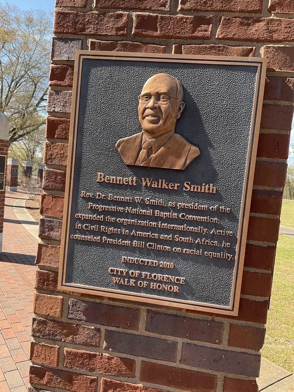
Near Hightower Place south of Veterans Drive (Alabama Route 133), on the left when traveling south.
Rev. Dr. Bennett W. Smith, as president of the Progressive National Baptist Convention, expanded the organization internationally. Active in Civil Rights in America and South Africa, he counseled President Bill Clinton on racial equality. — — Map (db m219184) HM
Near South Court Street at Canal Street, on the right when traveling south.
Toward the end of the 19th Century, the U.S. government decided that Native Americans should integrate into American culture and give up tribal sovereignty.
The Dawes Allotment Act forced Native Americans to register on what became known as . . . — — Map (db m212215) HM
On North Court Street 0.1 miles north of Hermitage Drive, on the right when traveling north.
Built in 1840's, acquired 1857 by Edward Asbury O'Neal. Occupied various times during Civil War by Federals and Confederates. Edward A. O'Neal (1818-1890) attended LaGrange College; lawyer, Colonel of the 26th Alabama Regiment, C. S. A.; appointed . . . — — Map (db m153224) HM
Near Hightower Place south of Veterans Drive (Alabama Route 133), on the left when traveling south.
Serving 16 years as president of the American Farm Bureau Federation (1931-1947), Mr. O'Neal developed major New Deal farm policies in the Franklin D. Roosevelt Administration. — — Map (db m219327) HM
Near Hightower Place just south of Veterans Drive (Alabama Route 133), on the left when traveling south.
A 1953 graduate of West Point, Gen. Brown culminated a 36-year military career as Director of the Army Staff (1983-1987) and Vice-Chief of Staff of the U.S. Army (1987-1989). — — Map (db m219297) HM
McVay (1766~1851), South Carolina native, built a three room log house at head of Cox's Creek about 1818. Community later called Mars Hill. He was a member of Mississippi Territorial Legislature, delegate to convention of 1819 which framed . . . — — Map (db m35260) HM
Near Hightower Place south of Veterans Drive (Alabama Route 133), on the left when traveling south.
Lawyer and statesman James T. Rapier, a son of free African-American parents in Florence, holds the distinction of being just the second African-American from Alabama to be elected, in 1873, to the U.S. Congress. — — Map (db m219173) HM
John McKinley (1780~1852), native of Virginia, prominent attorney, member of Cypress Land Company, built a large three story mansion near this site in 1820's which later burned. McKinley served in Alabama Legislature, U.S. Senate (1826~31); was . . . — — Map (db m28926) HM
Near Hightower Place south of Veterans Drive (Alabama Route 133), on the left when traveling south.
First serving as a member of the U.S. Senate (1826-1830), John McKinley was appointed to the U.S. Supreme Court by President Van Buren, becoming the first justice from Alabama. — — Map (db m219188) HM
Named for Alabama's first United States Supreme Court Justice, John McKinley made his home in Florence, Alabama from about 1821 to 1842. Born May 1, 1780 in Culpepper County, Virginia, he died July 19, 1852 and is buried in Louisville, Kentucky. . . . — — Map (db m28930) HM
Near Hightower Place south of Veterans Drive (Alabama Route 133), on the left when traveling south.
In 1891, G.W. Goethals, in his role as supervisor of public works on the Tennessee River, reported directly to the Secretary of War. Later, he was Chief Engineer for the construction of the Panama Canal. — — Map (db m219307) HM
Near Hightower Place south of Veterans Drive (Alabama Route 133), on the left.
Representing the Secretary of Defense at the Strategic Arms Reduction Talks in the 1980's, Michael Mobbs was a leader in negotiations between the U.S. and the U.S.S.R., resulting in the most complex arms control treaty in history. — — Map (db m219178) HM
In 1928, Oscar S. DePriest, son of former slaves, became the first 20th Century African-American Congressman from the north. He is credited with the Anti-discrimination Amendment to the 1933 Civilian Conservation Corps Bill. — — Map (db m219190) HM
Near Hightower Place south of Veterans Drive (Alabama Route 133), on the left when traveling south.
In his 14 years in the U.S. House of Representatives (1977-1991), Ronnie Flippo held such important posts as the chairmanship of the Space Science Subcommittee during the development of the space shuttle, Columbia. — — Map (db m219170) HM
On East Tuscaloosa Street at North Wood Street (County Road 47), on the right when traveling east on East Tuscaloosa Street.
This park, first designated as a Public Walk, was laid out as part of the original plans of Florence in 1818. On February 20, 1924, the Board of City Commissioners officially changed its name from City Park to Woodrow Wilson Park in honor of the . . . — — Map (db m35665) HM
1929 the Great Depression hit the United States hard, shattering the economy nationwide. While the Hoover administration did little to alleviate the economic problems facing the United States, the election of Franklin Delano Roosevelt in 1932 led to . . . — — Map (db m268967) HM
On College Street south of Tennessee Street, on the right when traveling south.
African-Americans played a very significant role in the early history of Courtland. Most came as slaves from the older southern states to help clear the land, to plant crops of cotton and corn, and to serve as household domestics. President . . . — — Map (db m278604) HM
On Market Street (Alabama Route 33) at Court Street (County Route 460), on the right when traveling south on Market Street.
Born 11 June 1769, in Maryland and married 18 Nov 1797, Anne Royall became a wealthy widow upon her Revolutionary War Veteran husband's death in 1813. However, her husband's family filed an ultimately successful suit for his estate. While she waited . . . — — Map (db m84309) HM
Wyatt Cheatham (1769-1856) was one of the early settlers of Lawrence County and bought land near Wren in 1818. The Alabama Legislature on 14 Dec 1824 authorized him, "to open out and make a road leading from at or near the Gum Pond in said county . . . — — Map (db m84310) HM
On Market Street (Alabama Route 33) at College Street, on the right when traveling south on Market Street.
General Leroy Pope Walker was born 7 Feb 1817 in Madison County, Al., son of John W. Walker (1784~1823). John was House Speaker of the AL Territory, the first constitutional convention president, the first US AL senator, and namesake of Walker . . . — — Map (db m69669) HM
On Market Street (Alabama Route 33) at College Street, on the right when traveling south on Market Street.
A scientist of national fame, Peters (1810-1888) lived for many years in Moulton with his wife Naomi (Leetch), a relative of President James K. Polk, who possibly visited here. A man of many talents, Peters was a noted linguist, early civil rights . . . — — Map (db m69670) HM
On County Road 23 at County Road 26, on the right when traveling north on County Road 23.
In 1843, David Hubbard (1792-1874), residing on a 120 acre tract in this section, was overseeing the construction of his mills and factories. A War of 1812 veteran and cousin to Sam Houston, David was the son of Revolutionary War officer Thomas . . . — — Map (db m262633) HM
On South Railroad Avenue just south of South 10th Street.
Mayor Bobby James Freeman Remembered for Transforming Opelika's Historic Core Mayor Bobby James Freeman served as a Lee County Commissioner for 10 years and as Mayor of the City of Opelika for eight years. During his tenure as Mayor, the . . . — — Map (db m296636) HM
On South 9th Street south of Avenue A, on the right when traveling south. Reported permanently removed.
Lee County Courthouse
Lee County was created from portions of Russell, Macon, Chambers and Tallapoosa by act of the Alabama Legislature, approved December 5, 1866. The County’s first election was held January 21, 1867.
An early . . . — — Map (db m85171) HM
On South 9th Street south of Avenue A, on the right when traveling south.
Lee County Courthouse
Lee County was created from portions of Russell,
Macon, Chambers and Tallapoosa Counties by act of
the Alabama Legislature approved December 5, 1866.
Lee County's first election was held January 21, 1867.
An . . . — — Map (db m297059) HM
On 4th Street at Grace Avenue, on the right when traveling west on 4th Street.
Wealthy and influential Virginia family settled here in 1820's. Daniel Coleman (1801-1857) built his stately home a block west about 1826. During the Civil War, home was occupied by Yankee troops who took Elizabeth Coleman's teeth for their gold . . . — — Map (db m85389) HM
On South Jefferson Street near West Washington Street, on the right when traveling north.
A section of the fence that surrounded the 'Court House' grounds until 1916. When construction of the present building was planned, the fence was moved to the County Poor Farm on Elkton Rd. This section donated to the people of Limestone County by . . . — — Map (db m85390) HM
On Market Street West near Houston Street, on the right when traveling west.
(Front):
This house was purchased by George S. Houston in 1845 and was his home until his death here on 31st December 1879. Houston served the people of Alabama in public office for thirty six years. His long and distinguished political . . . — — Map (db m85420) HM
On North Jefferson Street at Market Street West, on the right when traveling north on North Jefferson Street.
D.L. Rosenau, Jr. graduated from local Greene University School as Valedictorian at age 15 and went on to become one of the youngest graduates of both Yale University and Stanford Law School. Following his return to Athens, Judge Rosenau was . . . — — Map (db m154200) HM
On North Jefferson Street at Market Street West, on the right when traveling north on North Jefferson Street.
For more than a century, this bell rang in the Limestone County Courthouse to notify residents of the time of day and of momentous events. The Courthouse and surrounding Square have been the heart of this community since Limestone County's founding . . . — — Map (db m154199) HM
On Nick Davis Road (County Road 44) 0.5 miles west of Sanderson Road (County Road 127), on the left when traveling west.
Born April 23, 1781 in Hanover Co. Virginia, married there to Martha Hargrave of a wealthy Quaker family. He served as U.S. Marshall and in other positions. Moved to Kentucky in 1808. Was a Captain in the War of 1812 and became a political . . . — — Map (db m29284) HM
On Easter Ferry Road south of Morris Road (County Road 49), on the right when traveling south.
In the fall of 1806 a group of settlers led by William and James Sims, traveled from east Tennessee on flatboats down the Tennessee River and up the Elk River to this area. They landed near Buck Island and spread out into the surrounding . . . — — Map (db m250556) HM
On Lauderdale Street east of High Street, on the right when traveling west.
Post office contains original call boxes
Old tavern, 1817 used as stagecoach stop
Red Brick Methodist church 1817
U.S. Gen. James A Garfield was stationed here 1862
White frame church is more than a century old
Andrew Johnson was . . . — — Map (db m256323) HM
On West Tuskeena Street (Alabama Route 21) at South Commerce Street ( Route 97), on the left when traveling west on West Tuskeena Street. Reported permanently removed.
In the 1820s, Hayneville was known as "Big Swamp." In 1830, after being chosen as the county seat of Lowndes County, it was named Hayneville for Robert Y. Hayne, governor of South Carolina and a U.S. senator. The incorporation of Hayneville as a . . . — — Map (db m305560) HM
On Westside Street south of West Northside Street, on the left when traveling south.
In 1957, local government officials in Tuskegee, Alabama sought to gerrymander the city's limits in an attempt to diminish the number of black votes in upcoming elections. Alabama state senator Sam Engelhardt sponsored Act 140, which transformed . . . — — Map (db m139876) HM
On East Rosa Parks Avenue at Eastside Street, on the left when traveling east on East Rosa Parks Avenue.
Macon County was created by the Alabama Legislature on December 18, 1832 and formed out of land formerly belonging to the Creek Indians. The County was named for Nathaniel Macon, a Revolutionary War soldier and long-serving political leader . . . — — Map (db m99677) HM
On Bibb Street 0.2 miles north of Hudson Street, on the left when traveling north.
Charles Goode Gomillion (1900-1995) was born on April 1, 1900, in Johnston, South Carolina. He joined the faculty at Tuskegee University in 1928, where he served as dean of students and chair of the social sciences department. He was president of . . . — — Map (db m140006) HM
On West Montgomery Road at Kelly Drive on West Montgomery Road.
Side 1
Born in 1930 in Montgomery, Gray was among the foremost civil rights attorneys of the 20th century. Forced by segregation to leave Alabama to attend law school, he vowed to return and "destroy everything segregated I could find." . . . — — Map (db m101898) HM
On West Montgomery Road at Chambliss Street, on the left when traveling west on West Montgomery Road.
The Tuskegee Civic Association, whose offices were located here, started out of The Men’s Meeting of the 1920s and the Tuskegee Men’s Club of the 1930s. On April 13, 1941, in order to increase its effectiveness and to embrace all segments of the . . . — — Map (db m139923) HM
On Lee Highway/John T. Reid Parkway (U.S. 72 at milepost 109) at Brock Road, on the right when traveling west on Lee Highway/John T. Reid Parkway.
In May 1838 soldiers, under the command of U.S. Army General Winfield Scott, began rounding up Cherokee Indians in this area who had refused to move to Indian Territory in Oklahoma. About 16,000 Cherokees were placed in stockades in Tennessee and . . . — — Map (db m33318) HM
On John T Reid Parkway/Lee Highway (U.S. 72) 0.1 miles east of Walker Street, on the right when traveling west.
Home of Virginia Clay Clopton (1825-1915)
Author and Social Leader who was known in Washington society as "The Belle of the Fifties"
Whose first husband, Clement Claiborne Clay (1817-1882), was United States Senator from Alabama (1853-1861) and . . . — — Map (db m134092) HM
On U.S. 231/431 1 mile south of Grimwood Road (County Road 100), on the right when traveling south.
Near here lived
John Williams Walker (1783-1823)
President of Alabama's First
Constitutional Convention 1819
and Alabama's first U.S. Senator
1819-1822. Walker County in northwest
Alabama, created 1823, was named in
his honor. Four . . . — — Map (db m154289) HM
On Gates Avenue at Franklin Street S.E. on Gates Avenue.
Before statehood, the Alabama Territory had only limited rights of self government. Between July 5 and August 2, 1819, forty-four delegates from across the Territory convened in Huntsville to draft a constitution for statehood. Lawyers, . . . — — Map (db m26592) HM
On Greene Street Southeast at Eustis Avenue Southeast, on the left when traveling south on Greene Street Southeast.
On this site stood the Calhoun House, used as a Federal Courthouse, where desperado Frank James was tried and found not guilty, by jury trial, on April 25, 1884, for robbery of a government payroll near Muscle Shoals, Alabama, March 11, 1881. One of . . . — — Map (db m27771) HM
On Church Street Southwest north of Williams Avenue Southwest, on the right when traveling north.
City was scene of these "firsts" in Alabama:
1811 first town incorporated
1812 first Masonic Lodge chartered
1816 first bank incorporated
1819 first state constitution drafted
1819 first Governor inaugurated
1819 first session of . . . — — Map (db m27843) HM
On Northside Square at Eastside Square, on the left when traveling west on Northside Square.
Made a county in 1808 by order of Governor of Mississippi Territory.
Area ceded 1805, 1806 by Cherokees, Chickasaws.
This was the first land in Alabama ceded by these great civilized tribes. — — Map (db m27848) HM
On Southside Square at Madison Street SE, on the left when traveling east on Southside Square.
Madison Street is named after James Madison, author of the first ten Amendments to the Constitution, called "The Bill of Rights." He served as the fourth President of the United States and is often called "The Father of the Constitution." — — Map (db m279905) HM
On Franklin Street Southeast, on the right when traveling south.
Here, on July 5, 1819 forty-four delegates from twenty-two Counties in the Alabama Territory met to frame a State Constitution which was accepted and signed August 2, 1819.
Convention leadership was furnished by two Huntsvillians, John Williams . . . — — Map (db m27902) HM
Here, President James Monroe was honored at a public dinner on June 2, 1819, while on a three-day visit to the Alabama Territory. Here, also, the First Alabama Legislature convened on October 25, 1819, while Huntsville was the first Capital. — — Map (db m27851) HM
On Eastside Square at Eustis Avenue Southeast, on the right on Eastside Square.
Tallulah Bankhead 1902 - 1968. Alabama's Best-Known Actress.
Tallulah Bankhead was the toast of the London theatre in the 1920's, and nationally renowned for her dramatic roles in “The Little Foxes” (1939), “The Skin of Our . . . — — Map (db m27850) HM
On Front Street, on the right when traveling east.
This building is a replica of Madison's first city hall and is constructed on the original site of the Madison Depot, it was build in the late 1800's while Capt. John Buchanan Floyd, a Confederate veteran, was mayor.
"The Roundhouse" served as the . . . — — Map (db m103054) HM
Early in the 1800's gold was found from Virginia to Alabama including a rich belt on Cherokee Indian land in what is now Dahlonega, GA.
causing a huge influx of miners and a land grab by new settlers.
Pressure and greed from politicians led to . . . — — Map (db m85838) HM
Near Whitehall Road west of Hughes Road, in the median.
This site was the farm of Gilbert G. White Jr., his wife Nancy L. White, and family from 1947 to 2005. Mr. White lived here until his death in 1978. Gilbert G. White Jr. was a descendant of John White, Speaker of the US House of Representatives . . . — — Map (db m44268) HM
On North Commissioners Avenue north of West Lyon Street, on the left when traveling north.
Situated on historic White Bluff
overlooking the Tombigbee River,
Bluff Hall was built in 1832 by
slaves of Allen Glover for his
daughter, Sarah Serena, and her
husband, Francis Strother Lyon.
Lawyer and planter, F. S. Lyon, served in both . . . — — Map (db m37997) HM
On Military Street South (U.S. 278) at 1st Avenue SW, on the right when traveling south on Military Street South.
Side 1
February 13, 1818 — Gin Port - west of Amory, MS on Tombigbee River
December 16, 1819 — Henry Grier House, near Columbus, MS - first designated courthouse
Late 1820-1822 — Military Ford Court - under . . . — — Map (db m96791) HM
On Dauphin Street at North Lawrence Street, on the left when traveling east on Dauphin Street.
Andrew N. Johnson, born 1865 in Marion, Alabama, graduated from Talladega College in 1886, and taught in rural Alabama. On this site in 1894, he established the Mobile Weekly Press, a voice for African-Americans, "A.N.", a powerful member of the . . . — — Map (db m111347) HM
On Martin Luther King Jr. Avenue at Peach Street, on the right when traveling west on Martin Luther King Jr. Avenue.
C. First Johnson was an entrepreneur, pastor of St. Louis Street Baptist Church, and lecturer. Johnson ran for political office in the 1890's. He founded the Union Mutual Aid Association, Mobile's first black-owned insurance company. By 1911, his . . . — — Map (db m111317) HM
A postal worker, a community leader, a state legislator, a journalist, and a civil rights activist, Mobile native John L. LeFlore spent 50 years working to peacefully transform the character of the city and create opportunities to enhance citizens' . . . — — Map (db m111413) HM
On St Francis Street at North Warren Street, on the right when traveling west on St Francis Street.
After the NAACP was outlawed in 1956, LeFlore and the Non-Partisan Voters League took a more active role in civil rights in Mobile. LeFlore served as its director of casework. He was a plaintiff in Bolden vs. Mobile and the judgement changed . . . — — Map (db m86391) HM
Joseph (Joe) N. Langan devoted his life to helping others and championing noble causes. He provided wisdom as a city and stare leader and served courageously
as a U.S. Army officer during World War II and the Korean War. As a leading
advocate for . . . — — Map (db m111415) HM
On Oakleigh Place at Savannah Street, on the left when traveling north on Oakleigh Place.
Started in 1833 by James Roper on a Spanish land grant, “Oakleigh” was named for the magnificent oaks around it. The “T” shaped dwelling with elegant parlors and curved outside stairway from the brick terrace to front gallery . . . — — Map (db m85908) HM
On Conti Street at South Joachim Street, on the left when traveling west on Conti Street.
"I want to take this occasion to say that the United States will never again seek one additional foot of territory by conquest. She will devote herself to showing that she knows how to make honorable and fruitful use of the territory she has and she . . . — — Map (db m86381) HM
Native of Montreal, Canada, Naval Officer of France,
Governor of Louisiana
and Founder of the first Capital, Mobile, in 1711.
Born 1680 — Died 1768
——
With the Genius to create an Empire
and the Courage to maintain . . . — — Map (db m86732) HM
On Martin Luther King Jr. Avenue at Patton Avenue, on the right when traveling east on Martin Luther King Jr. Avenue.
Vernon Crawford established the first African-American law firm in Mobile. He successfully argued the Birdie Mae Davis case that desegregated Mobile schools. He stood before the Supreme Court and won the landmark case of Bolden vs. the City of . . . — — Map (db m111319) HM
On Government Street at S Hamilton Street, on the right when traveling east on Government Street.
Influenced the cultural development of Spain • Founder of schools • Author of songs • Revised Ptolemaic Planetary Tables • Selected by city of Toledo as most peace sensitive early ruler — — Map (db m294628) HM
On Government Street at S Hamilton Street, on the right when traveling east on Government Street.
Born in Macharaviaya, Málaga, Spain •
Governor of the Territory of Louisiana • Captured Mobile March First 1780 • Beginning thirty-three years of Spanish rule in Mobile — — Map (db m294627) HM
On Old Military Road East (Alabama Route 96) 0.1 miles north of Old Military Road South, on the right when traveling north.
From 1799 to 1817, this portion of the United States fell.
within Mississippi Territory (from which the present-day states
of Mississippi and Alabama were created), and the area north
of Mobile consisted of two parts: Tombigbee District west . . . — — Map (db m149309) HM
On North Alabama Avenue (State Road 21), on the left when traveling north.
Created in 1815 by proclamation of Governor of Mississippi Territory from lands ceded by Creek Indians in Treaty of Ft. Jackson, 1814.
Named for President James Monroe, fifth President of U.S.., 1817-25, who purchased Florida from Spain, . . . — — Map (db m47695) HM
On U.S. 84 at Old Fort Claiborne Road, on the right when traveling west on U.S. 84.
During the westward expansion of the United States in the early 1800’s, those whose destination was the new Mississippi Territory took a right fork off the Federal Road which led to the Alabama River ferry at Claiborne. After the land cessions of . . . — — Map (db m47638) HM
On Lemay Plaza 0.1 miles south of Maxwell Boulevard, on the right when traveling south.
This facility is dedicated to the memory of Senator Lister Hill who faithfully served his state and the nation for forty-five years as a member of the House of Representatives and the United States Senate. An Infantry Officer during World War I, . . . — — Map (db m79082) HM
Near Monroe Street east of North Bainbridge Street, on the right when traveling east.
To the memory of Albert L. Patterson, 1896-1954.
Soldier, educator, attorney, State Senator, Attorney General-Elect. An honorable life dedicated to his fellow man and to the cause of good government. Shot down by an assassin's bullet June 18, . . . — — Map (db m221983) HM
On Dexter Avenue 0.3 miles west of South Decauter Street, on the right when traveling west.
"We are not final because we are infallible, but we are infallible because we are final."
Associate Justice Robert H. Jackson, Supreme Court of the United States
Lucien D. Gardner
Chief Justice 1940-1951
Associate . . . — — Map (db m269449) HM
On Tullibody Drive at University Drive North, on the right when traveling south on Tullibody Drive.
1868-1869: Senate: Benjamin F. Royal, Bullock; House: Benjamin Alexander, Greene; James H. Alston, Macon; Samuel Blandon, Lee; John Carraway, Mobile; George Cox, Montgomery; Thomas H. Diggs, . . . — — Map (db m91290) HM
On Monroe Street east of North Bainbridge Street, on the right when traveling east.
The Alabama Legislature approved a bill sponsored by Rep. T.E. Martin of Montgomery County in 1927 that designated the Goldenrod the official state flower. It became law on Sept. 6, 1927, the same day that the Yellowhammer became the official . . . — — Map (db m86066) HM
Near Dexter Avenue at North Decatur Street, on the right when traveling east.
A native of Opelika, Alabama, he is the son of Clement C. Torbert and Lynda Meadows Torbert. He was educated in the Opelika public schools. He attended the United States Naval Academy and received his B.S. Degree from Auburn University in 1951. He . . . — — Map (db m86073) HM
Near Dexter Avenue at North Decatur Street, on the right when traveling west.
Born in Montgomery, Alabama, he is the son of Ernest Arnold Hornsby and Kate Clayton Hornsby. A 1955 graduate of Tallassee High School, he received his B.A. Degree from Auburn University and his Juris Doctor Degree from the University of Alabama . . . — — Map (db m69338) HM
On Dexter Avenue at South Hull Street, on the right when traveling east on Dexter Avenue.
Side 1
Born in 1930 in Montgomery, Gray was among the foremost civil rights attorneys of the 20th century. Forced by segregation to leave Alabama to attend law school, he vowed to return and "destroy everything segregated I could find." . . . — — Map (db m80842) HM
On Adams Avenue at South Hull Street, on the left when traveling east on Adams Avenue.
Thomas Goode Jones, governor of Alabama from 1890-1894, occupied this house during his long political career which took him from the Montgomery City Council to a federal judgeship. During his two terms as governor, his home was the Executive Mansion . . . — — Map (db m36585) HM
Near Stella Street at Clarmont Avenue, on the right when traveling north.
Governor William Calvin Oates
Born in Pike County into a poor Alabama family in 1835, Oates practiced law in Abbeville when the War began. Elected Captain of the "Henry Pioneers," Co. G, 15th Alabama Infantry. He saw service in Jackson's . . . — — Map (db m86116) HM
Near Dexter Avenue east of Decatur Street, on the right when traveling east.
Great Depression
The U.S. economy collapsed in late 1929, triggering a
national crisis. Alabama's rural residents had weathered
hardship for decades. Now urban workers and professionals
also faced economic ruin. Businesses closed, factories . . . — — Map (db m182629) HM
On North Bainbridge Street at Dexter Avenue, on the right when traveling north on North Bainbridge Street.
A graduate of West Point Military Academy, he served the United States as Colonel of Mississippi Volunteers, Mexican War; member of House of Representatives, Senator, and as Secretary of War. Inaugurated President of the provisional government, . . . — — Map (db m155530) HM
On Dexter Avenue at South Hull Street, on the left when traveling east on Dexter Avenue.
Side A Jonathan Coggswell Farley 1798-1864Farley acquired two lots on this site in 1817. Here he built both the town's first frame store and first frame two-story building, his house. In Farley's store, an election was held January 3, 1820 . . . — — Map (db m86124) HM
On Montgomery Street at Catoma Street, on the right when traveling south on Montgomery Street.
Following two attempted marches from Selma in 1965
civil rights leaders turned to the federal courts for legal
protection prior to the Selma To Montgomery March.
Federal District Court Judge Frank M. Johnson, Jr.,
appointed by President . . . — — Map (db m91321) HM
Near Dexter Avenue at North Decatur Street, on the right when traveling west.
A native of Troy, Lucien Dunbibben Gardner graduated with a Bachelor of Science Degree, from the State Normal School at Troy in 1894. He earned his Bachelor of Arts Degree from The University of Alabama and graduated from the Law Department in 1897. . . . — — Map (db m69333) HM
On North Perry Street at Monroe Street, on the left when traveling south on North Perry Street.
Built 1936-37 Following a fire in 1932 that destroyed a 19th century City Hall, architect Frank Lockwood designed a replacement for the same site. With the Depression affecting all construction projects during the period, the city received . . . — — Map (db m36571) HM
On Dexter Avenue east of South Decatur Street, on the right when traveling east.
Populism
Through the 1870s and 1880s, depressed cotton prices
brought suffering and hardship for hundreds of thousands
of farm families, black and white. In the 1890s, a coalition
of small farmers and industrial laborers challenged . . . — — Map (db m182616) HM
On Alabama Street east of South McDonough Street, on the right when traveling east.
Only surviving residence of former Mayor E.B. Joseph. The Italianate cottage was built c. 1855 by Pickett Chauncey Smith, a merchant in antebellum Montgomery, and father-in-law of E.B. Joseph, who occupied the house from 1880 to 1885. Joseph served . . . — — Map (db m86426) HM
On Dexter Avenue at North Hull Street, in the median on Dexter Avenue.
The Supreme Court Of Alabama
The supreme court is the highest state court in Alabama. It is composed of a chief justice and eight associate justices elected statewide for a term of six years. The Supreme Court has the power to review . . . — — Map (db m268896) HM
On Dexter Avenue 0.3 miles west of South Decauter Street, on the right when traveling west.
1819 The First Constitution of Alabama (1819), under which the state was admitted to the Union, provided that "until the General Assembly shall otherwise prescribe, the powers of the Supreme Court shall be vested in, and its duties shall be . . . — — Map (db m269447) HM
On Bibb Street at Commerce Street, on the right when traveling west on Bibb Street.
Here were located the first offices of the Confederate government from Feb. 22, 1861 to May 21, 1861.
Secondary marker:
This historic marker relocated on this original site by Preceptor Delta Chapter, Beta Sigma . . . — — Map (db m104718) HM
On Church Street at Lee Street, on the right when traveling north on Church Street.
Named in honor of Judge Frank M. Johnson, Jr. (1918-1999), who served here as U.S. District Judge from 1955-1979, as U.S. Circuit Judge of the United States Court of Appeals for the Fifth Circuit July 12, 1979 - October 1, 1981, and as U.S. . . . — — Map (db m71266) HM
On Dexter Avenue at South Bainbridge Street, on the right when traveling east on Dexter Avenue.
On Thursday, March 25, 1965, the Selma to Montgomery
marchers left St. Jude and continued through the streets
of Montgomery, the crowd swelling in numbers as they
approached Court Square. By the time they reached
Dexter Avenue, a crowd of more . . . — — Map (db m91322) HM
On East Jefferson Street 0.1 miles east of North Hull Street, on the left when traveling east.
In the house just north
William Lowndes
Yancey
Statesman, Orator, Secessionist,
Confederate Diplomatic
Commissioner
Died July 28, 1863 — — Map (db m71364) HM
On South Lawrence Street at Washington Avenue, on the right when traveling south on South Lawrence Street.
Created by Mississippi Territorial Legislature from lands ceded by Creek Indian Nation in Treaty of Fort Jackson, 1814. Named for Major Lemuel Purnell Montgomery, killed at Horseshoe Bend, 1814, while leading charge on Indian fortifications. . . . — — Map (db m36579) HM
On South Decatur Street (Alabama Route 21) at Scott Street on South Decatur Street.
This was the site of the home of Warren Stone Reese (1842-1898) --planter, cotton merchant, soldier, and mayor of Montgomery.
Reese, promoted to the rank of colonel in the Confederacy for gallantry at Chickamauga, became commander of the . . . — — Map (db m81807) HM
10501 entries matched your criteria. Entries 101 through 200 are listed above. ⊲ Previous 100 — Next 100 ⊳