To the Memory
Of the Men of
This Parish Who
Gave Their Lives
In the Great War
1914 – 1918.
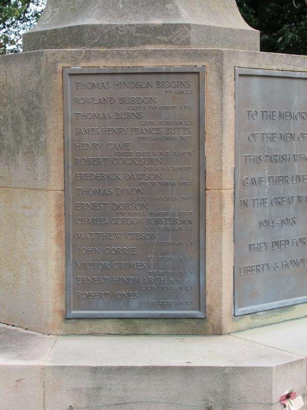
Thomas Hindson Biggins Pte Som. L.I. · Rowland Burdon Capt. & Flt. Comdr R.F.C. · Thomas Burns L/Cpl Durham L.I. · James Henry Francis . . . — — Map (db m125904) WM
British Coal Corporation
Horden Colliery
Shaft Ref. North
Shaft Diameter 6090 mm
Shaft Depth 438 M
Depth to top of cap from top of monument 2 M
Date of Capping Aug. 94 — — Map (db m125912) HM
“For Home and Country”
Erected to the Memory of the
Men from this Parish who
Served in the Great War
1914 – 1918.
Those Who Fell
Richard Bell Adamson. · Robert Hodgson Adamson. · John Christopher Baty. · John Edward . . . — — Map (db m126343) WM
Eleven ‘O’ One
Known locally as ‘Tommy’
was bought on Aug 4th 2014
from the public local schools
businesses and Durham County
Council. He sits here
for future generations to
visit, enjoy and remember.
By — Ray Lonsdale
Two . . . — — Map (db m125911) WM
Remember
With Thanksgiving
The True and Faithful Men
Who In The Great War
Went Forth From This Parish
For God and the Right
The Names of Those
Who Returned Not Again
Are Here Inscribed
To Be Honoured For Evermore
1915 — . . . — — Map (db m126340) WM
This illustration shows the castle as it may have appeared in the early 19th century. The great windows in the keep are closed with wooden shutters to keep out the cold, and at the top flies the flag of Robert de Vieuxpont, Lord of Brougham. Men in . . . — — Map (db m246669) HM
The keep is the oldest part of the castle that is still standing. The bottom three storeys were built around the end of the 12th century. You are now in the basement which was used as a storeroom. In its early days the first floor would have been . . . — — Map (db m246668) HM
King Edward I died in Burgh-by-Sands on 7 July 1307 whilst leading a campaign against Robert the Bruce. He was laid in St. Michael's Church.
This plaque was unveiled by HRH The Duke of Kent, KG, GCMG, GCVO
on 3 July to mark the . . . — — Map (db m85599) WM
The two archways to your right are less than a hundred years old. They were constructed through the porches of the old Court Buildings in the late 1920s when a need to widen the road to accommodate the growth in traffic saw the wide pavements . . . — — Map (db m246683) HM
The towers were erected in 1810 from original designs by Thomas Telford completed by Sir Robert Smirke. They replace similar structures built on the order of Henry VIII in 1542 by his military engineer, Stefan Von Haschenperg to guard the southern . . . — — Map (db m246681) HM
Great Dockray is Penrith's largest open market and the location with Sandgate of the former Whitsunside and Martinmas hiring fairs, every Tuesday the street market held in earlier times bull-baiting took place here when it was an offence, punishable . . . — — Map (db m245889) HM
Following the death of Richard, 2nd earl of Salisbury in 1471, the castle was granted to Richard, duke of Gloucester (1452-1485), who later became King Richard III.
The future king resided at the castle for periods between 1471 and 1483, as he . . . — — Map (db m245699) HM
In 1396 Ralph Neville was given the Manor of Penrith and thereafter built this castle. Neville was an important figure in the safety of the western border with Scotland, but his castle here was more a place of comfort and luxury than strategic . . . — — Map (db m245701) HM
The Parish Church, rebuilt in 1720-1722, incorporates a medieval west tower and a galleried interior, and has been described as 'the stateliest church of its time in the county'. The architect is not known, but the church is in the style of Nicholas . . . — — Map (db m245886) HM
This castle was built at the end of the 14th century by Ralph Neville, who played a key role in the defence of the Scottish border.
Ralph Neville (c.1364-1425) was granted the manor of Penrith in 1396 and built the castle soon afterwards. As . . . — — Map (db m245697) HM
Derby's first non-conformist chapel stood on this spot until 1974. Built by the Presbyterians in 1696, it transferred to the Unitarians in 1781.
The ground upon which it stood, formed part of the property of the Dominican Friary that was . . . — — Map (db m246642) HM
A national coast to coast route for walking, cycling and in places, horse riding. Linking vibrant cities, peaceful countryside, sunny seaside, timeless villages, historic market towns and dramatic Pennine moorland...
You'll find the Trans . . . — — Map (db m246808) HM
Park Cemetery was opened in 1892 by Ilkeston Corporation on 22 acres of land bought from the Anglican Parish of Ilkeston at a price of £150 per acre. The twin Cemetery Chapels were constructed in 1910 and are Grade II listed buildings. The Cemetery . . . — — Map (db m246643) HM
Historical Axminster
Abbeyfield
Standing opposite the Old Carpet Factory, this large house was built in 1797 to replace an earlier vicarage, which was from 1834 to 1848, the home of Reverend W.D. Conetbeare, an eminent geologist and vicar of . . . — — Map (db m123750) HM
In Grateful Memory of the
Men of Axminster
Who Died for Their
Country in The
Great War 1914 – 1918
Bertram P. Bowles · Henry A. Bruce · John S. Channing · Charles S. Chant · Francis F. Chick · William C. Chick · William A. Claybin · . . . — — Map (db m123632) WM
Historical Axminster
Cattle Market
A Charter was granted to the town in 1210, which included the right to hold a weekly market. The market was held in Market Square until 1834. It then moved to Trinity Square.
The Market then moved to this site . . . — — Map (db m123748) HM
Historical Axminster
Law Chambers
Standing beside the Old Carpet Factory, this double fronted house was at one time the home of Thomas Whitty. It is now occupied by a firm of solicitors.
Rotary Club of Axminster
Serving the Community for 50 . . . — — Map (db m123749) HM
Historical Axminster
Rose Cottage
Listed Grade II Property. Thought to date from circa 1630. The last thatched property within the town. Many original features including the Old Pump within the garden frontage, timbered ceilings, cob walls, . . . — — Map (db m123747) HM
Historical Axminster
The Old Carpet Factory
This large grey stone building was erected in 1828 on the site of Thomas Whitty’s original carpet factory, which was destroyed by fire two years earlier.
Closed as a factory in 1835, it was used as . . . — — Map (db m123751) HM
The Trafalgar Way
Axminster - 9th Post-Horse Change
On Monday, 21st October 1805 the Royal Navy decisively defeated the Combined Fleet of France and Spain off Cape Trafalgar south of Cadiz. This victory permanently removed the threat . . . — — Map (db m122166) HM
In Memory of Philip Freeman/Friedman
Jewish Exeter Wartime Firewatcher
Age 67
Who was killed in the German bombing raid,
4 May, 1942.
Till 2022, his grave was unidentified
Hebrew Acronym v
(Samuel, 25:29, “May his soul be . . . — — Map (db m212023) WM
To the Glory of God and
In Honoured Memory of
The Men of Kilmington
Who Gave their Lives for
Their King and Country in
The Great War
E.W. Woodman Died 1915 · J.H. Woodman Died 1915 · L.F. Loveridge Died 1916 · W. Sanaom Died . . . — — Map (db m123752) WM
The Trafalgar Way
Kilmington
On Monday, 21st October 1805 the Royal Navy decisively defeated the Combined Fleet of France and Spain off Cape Trafalgar south of Cadiz. This victory permanently removed the threat of invasion of England . . . — — Map (db m122162) HM
It seems likely that mute swans nested on the Fleet long before the earliest written record of 1393, which gave us the name of William Squillor - a monastery swanherd. Monks took advantage of this ready supply of fresh meat but today the ‘Game of . . . — — Map (db m123628) HM
In Remembrance
of God’s dreadful Vifitation by Fire
which Broke out the 4th June 1731,
and in few Hours reduced, not only the
Church and almoft this whole Town to Afhes
wherein 14 Inhabitants perifhed,
but also two adjacent Villages . . . — — Map (db m123576) HM
( left panel )
To Commemorate the Self-Sacrifice
of Those Whose Names Are
Inscribed Hereon Who Gave Their
Lives for Their Country in The
Great War 1914 - 1918
Alexander C.B. · Andrews J.J. · Arnold G. · Arscott B.J. · Axford . . . — — Map (db m123575) WM
Jack Counter VC
Born and died in Blandford Forum
3rd November 1898 — 16th September 1970
16h April 2018 marks the centenary of the actions carried out by Private Jack Thomas Counter of the King's Liverpool Regiment near Boisieux St. Marc, . . . — — Map (db m123577) HM WM
The Battle of Blandford: defences against a German invasion in World War II “We shall defend our island, whatever the cost may be, we shall fight on the beaches, we shall fight on the landing grounds, we shall fight in the fields and in . . . — — Map (db m123574) HM
The Trafalgar Way
Blandford Forum - 12th Post-Horse Change
On Monday, 21st October 1805 the Royal Navy decisively defeated the Combined Fleet of France and Spain off Cape Trafalgar south of Cadiz. This victory permanently removed the . . . — — Map (db m122167) HM
Centurion Mark 12 Hull with Fv4005 Turret
This British vehicle is a Centurion tank hull fitted with a 183mm L4 gun - the biggest
direct fire gun ever mounted on a tank. It was built after the Second World War to
counter the threat of the . . . — — Map (db m123579) HM
The Challenger I design was originally planned for the Imperial Iranian Army and was due to be named the Shir (Lion) I. With the fall of the Shah (King) in 1979, the vehicle was renamed Challenger and adopted by the British Army to replace . . . — — Map (db m123585) HM
FV603B Armoured Personnel Carrier, Mark 5
The Alvis FV603 Saracen was an armoured personnel carrier and part of the FV600 series of vehicles. It first appeared in 1952 and saw action during the Malayan Emergency (1948-1960).
It was later . . . — — Map (db m123587) HM WM
In Memory of Those Serving in the Household Cavalry Armoured Corps Who Have Died on Operations Since 1945
Take these men as your example.
Like them remember
That prosperity can only be for the free,
Who alone have the courage to defend . . . — — Map (db m123581) WM
M4A1 Medium Tank, Grizzly Mark I
During the Second World War the Canadians built the M4A1 Sherman named 'Grizzly.' It had a few modifications including a Canadian Dry Pin Track (if you look at the tracks there is no rubber used). The Grizzly . . . — — Map (db m123580) HM WM
This exhibit is a fibreglass model used to create the bronze statue that now stands in Whitehall Place, London. The London statue was unveiled by the Royal Tank Regiment's Colonel in Chief, Her Majesty the Queen, on the 13th of June 2000.
The . . . — — Map (db m123583) HM WM
This tank had been restored to the appearance of a Mark I Churchill, belonging to the 14th Canadian Tank Regiment. The Mark I was armed with a 2-pounder high velocity anti-tank gun in the turret and a 3 inch howitzer in the hull. The Churchill . . . — — Map (db m123586) HM WM
This arena was a gift from the people of Kuwait in recognition of the sacrifice made by soldiers of the British Army in the Liberation War 1990–1. — — Map (db m121954) WM
Thomas Edward Lawrence; born 16 August 1888, Tremadoc, North Wales - died 19 May 1935, Bovington Camp, Dorset. Known to his mother as Ned but to the rest of the world as Lawrence of Arabia.
The Tank Museum contains a display which gives various . . . — — Map (db m123584) HM WM
No. 9 Last Street
This building originally The
George Inn was rebuilt by
renowned local Apothecary
Dr. Giles Roberts in 1804.
It was a Pharmacy until 1971. — — Map (db m123629) HM
The Trafalgar Way
Bridport - 10th Post-Horse Change
On Monday, 21st October 1805 the Royal Navy decisively defeated the Combined Fleet of France and Spain off Cape Trafalgar south of Cadiz. This victory permanently removed the threat . . . — — Map (db m122165) HM
A large Norman castle, built in the late 11th century, once dominated the town of Christchurch. This mound, or motte, originally had a timber tower which was replaced in stone in about 1300. The other castle buildings, including the fine Norman . . . — — Map (db m221645) HM
In the Saxon period the adjacent site was occupied by the Church of the Holy Trinity. Between the 11th and 16th centuries evolved the present Priory Church
The Court House for the Priory Manor of Christchurch Twyneham stood beyond this wall . . . — — Map (db m221533) HM
The earliest documented evidence for a ducking stool in Christchurch is in the Borough Records dating from the mid-14th century. In May 1350 a property deed mentioned a 'Schulffyngstol, another dated September 1468 calls it a 'Shylvyngstole'. . . . — — Map (db m221524) HM
The construction of a castle and monastery transformed the fortified settlement of Twynham.
Twynham (the place between rivers') was part of a series of strategic defended places established by the Saxon King Alfred. In about 1100, the town was . . . — — Map (db m223370) HM
This stone was laid by the Mayor of Christchurch Councillor Michael J. Peirce to commemorate the 50th Anniversary of the end of World War II
3rd September 1939 to 15th August 1945
"Lest We Forget" — — Map (db m221540) WM
1939 - 1945
R Parsons · P. Young
1914 - 1918
Remember Before God With Thanksgiving
These Men Who Gave Their Lives in the War
F.J. Bugess · C.G. Christopher · C. Cutler · R.J. Daniels · W.J. Bennett · E.N. Dorey · R.J. Diment · W.H. . . . — — Map (db m123753) WM
World War II 1939-1945
This Stone is to Commemorate
All Those Allied Service Men and Women
Who Served Here in Dorchester
And in the County of Dorsetshire
And to All Those Who Fought
All Over the World
On Land Sea and in the Air
Never . . . — — Map (db m123623) WM
To the Glory of God and
In Proud Memory of These
Members of our Church & Parish
Who Died For Us In the Great War
Lt. W.E. Hill N.Staf.Regt. Sep. 25. 1914 · Pte. A. Pink Dorst. Regt. Oct. 13. 1914 · Capt. C.G.W. Andrews Bordr. Regt. . . . — — Map (db m123618) WM
To The Glory Of God
And In Eternal Memory
Of Those Who Gave Their
Lives In The War 1914-1978
Greater Love Hath No Man Than This, That
He Lay Down His Life For His Friends
Arthur E. Ashton · Charles J. Benger · Leonard R. Archer · . . . — — Map (db m123617) WM
The Roman Walls
This is the only surviving section of Dorchester's Roman walls.
The Roman town of Dorchester, called Durnovaria, was a provincial capital with a garrison of soldiers. The town was protected on three sides by walls and ditches, . . . — — Map (db m123627) HM
The Trafalgar Way
Dorchester - 11th Post-Horse Change
On Monday, 21st October 1805 the Royal Navy decisively defeated the Combined Fleet of France and Spain off Cape Trafalgar south of Cadiz. This victory permanently removed the threat . . . — — Map (db m122163) HM
In This Building
On March 19th, 1834
The Six Tolpuddle Martyrs Were Sentenced
To Seven Years Transportation
For Their Part in The Founding
Of Rural Trade Unionism
Unveiled by Alderman E.G. Good C.B.E.,J.P.,M.P.
President of the . . . — — Map (db m123621) HM
The Fox Inn was built over 250 years ago as The home of Charles Hall and known as Broadclose. In 1777 Charles founded the Ansty Brewery while troops were assembling on The Dorsetshire coast anticipating a French invasion during the Napoleonic . . . — — Map (db m120988) HM
From this hotel in 1865 until the lifeboat station moved to East Quay in 1882, on lifeboat calls the crew was taken by horse brake to their station at Sandbanks, which is now the site of the Royal Motor Yacht Club.
In 2015 the Poole lifeboat . . . — — Map (db m230573) HM
Victoria Square's development in the 1860
came as a result of Portland Branch
Railway, which extended from Weymouth
to Portland. Construction on the line
commenced in 1860 and it opened on 16
October 1865. Terminating at a station at
the . . . — — Map (db m216342) HM
Built in the 16th century the Black Dog public house is one of the oldest pubs in the town. Although the date above the left ground floor window reads 1621 the back of the building is much older. The pub was originally called The Dove until the 16th . . . — — Map (db m216198) HM
Battle Formation
Early on the autumn morning of Saturday 14 October 1066 two great armies are preparing to fight for the throne of England.
On the top of this hill are arrayed the English forces of Harold Godwinson, who was crowned king just . . . — — Map (db m128720) HM
Battle town and the abbey’s estates
Much of the land you can see was owned by Battle Abbey. William the Conqueror granted the monastery all the land within a radius of 1.5 miles of the abbey's high altar. The abbot of Battle had power over both . . . — — Map (db m128711) HM
Battlefield to Vegetable Garden
The garden behind this wall was part of the 19th century country estate, but was perhaps a garden or orchard in earlier times.
The land here is part of the original battlefield, part of the slope defended by . . . — — Map (db m128796) HM
Beehives in the Walled Garden
The hives in the garden are based on an 1890s design by William Broughton Carr. The wooden hives help the bees stay cool in summer and warm in winter. They are built in sections using frames, so the bees are less . . . — — Map (db m128800) HM
Dairy and Icehouse
The dairy and icehouse were part of the abbey's later life as a country estate. They were probably constructed by Sir Godfrey Webster around 1818 for his new wife.
The octagonal dairy (left), in the fashionable Gothick . . . — — Map (db m129334) HM
Dusk. William Victorious
The Normans finally break through the shield wall and the English army is routed.
During the final Norman assault the English shield wall breaks. The Normans begin to slaughter any who stand against them.
Those . . . — — Map (db m128795) HM
East Range of Cloister
This was extensively rebuilt in the
13th century. The first floor was
the monk’s dormitory. The doorway
above led to a day-stair to the
cloister. — — Map (db m129379) HM
‘On the very spot’
Sources written within living memory of the Battle of Hastings in 1066 state that Battle Abbey was founded by William the Conqueror ‘on the very spot' where he had secured his great victory over King Harold and the English. . . . — — Map (db m128710) HM
Parlour
This was one of very few rooms where
the monks were allowed conversation.
It was rebuilt in the 13th century.
The doorway in its eastern wall led
to the infirmary. — — Map (db m129346) HM
Rebuilding the Abbey Church
The most important part of an abbey church was its eastern end — here were the altars and the choir where the monks worshipped.
The most ambitious part of the 13th-century modernisation of the abbey was the . . . — — Map (db m129336) HM
Stalemate
The successful Norman counter-attack brings the first phase of the battle to an end.
It is probably early afternoon before the first phase of the battle has come to a close. Neither side has yet won a clear advantage. By now the men . . . — — Map (db m128789) HM
The 11th-century Church
When William the Conqueror founded Battle Abbey he ordered that the church's high altar should be placed on the spot where Harold had fallen.
The stone slab marks the site of the death of King Harold towards the evening . . . — — Map (db m129338) HM
The Abbey and its History
William the Conqueror founded Battle Abbey in 1070 as a memorial to the Battle of Hastings and as an act of atonememt for the bloodshed.
It was carefully laid out on this hillside with the church on the ridge. The . . . — — Map (db m128792) HM
The Afternoon Assaults: Norman Trick Tactics
During the afternoon the Normans weaken the English line by adopting a new tactic.
It is now clear that the English are not going to be easily defeated. To create gaps in the shield wall, groups of . . . — — Map (db m128790) HM
The Afternoon Assaults: Norman Trick Tactics
During the afternoon the Normans weaken the English line by adopting a new tactic.
It is now clear that the English are not going to be easily defeated. To create gaps in the shield wall, groups of . . . — — Map (db m129380) HM
The Battle of Hastings and Battle Abbey
The Battle of Hastings was fought here on 14 October 1066. It is the most famous battle on English soil and its outcome had a profound impact on the history of England.
William the Conqueror's . . . — — Map (db m128713) HM
The Chapter House
The chapter house was second only to the church as the focal point of monastic life.
Monks assembled here each morning to hear readings, including a chapter of the Rule of St Benedict, hence the room's name. Business matters . . . — — Map (db m129345) HM
The Cloister
The main abbey buildings were arranged round a cloister on the south side of the church.
Sheltered from cold north winds they would catch the sun. The cloister walks or alleys, marked out by the gravel paths, enclosed a garden and . . . — — Map (db m129341) HM
The Dormitory
This huge room was the dormitory, or dorter, where the monks slept. It dates to the 13th century and was originally a single open space without any heating. Monks slept communally and their single beds were arranged in rows along the . . . — — Map (db m129365) HM
The Duchess of Cleveland’s Walled Garden
The walled garden is planted today with fruit trees, recreating the work of the Duchess of Cleveland.
The Duke and Duchess, who bought Battle Abbey in the mid 19th century, were keen gardeners. The . . . — — Map (db m128799) HM
The East Range
These buildings contained the dormitory and the monastic latrines.
The first floor of the east range in front of you was a single large dormitory or dorter where originally the abbot and all the monks slept. To the left of it, . . . — — Map (db m128797) HM
The First Norman Attack
The battle opens to the terrible sound of trumpets on both sides.
William's men advance up the hill to attack the English shield wall. They are led by lightly armed foot soldiers and archers. Behind them are ranks of . . . — — Map (db m128718) HM
The First Norman Attack
The battle opens to the terrible sound of trumpets on both sides.
William's men advance up the hill to attack the English shield wall. They are led by lightly armed foot soldiers and archers. Behind them are ranks of . . . — — Map (db m128723) HM
The Great Gatehouse
The imposing size and elaborate decoration of the great gatehouse reflected the power and importance of Battle Abbey.
This was the main entrance for visitors, as well as for merchants, traders and abbey staff bringing . . . — — Map (db m128716) HM
The Traditional Site of
The High Altar of Battle Abbey
Founded to Commemorate
The Victory of Duke William
On 11 October 1066
The High Altar Was Placed to Mark
The Spot Where King Harold Died — — Map (db m129337) HM
The Norman Counter-Attack
After rallying his forces, William counter-attacks the English.
Encouraged by Duke William, the Normans turn and attack the English who have pursued them down the hill. Those who have been separated from the safety of . . . — — Map (db m128788) HM
The Norman Retreat
After ferocious fighting the first Norman attack falters and breaks.
The left wing of Duke William's army, including a group of knights from Brittany, is driven back by the English. At the same time rumour spreads that Duke . . . — — Map (db m128724) HM
The Outer Court
You are standing in what was the outer court of the abbey, where its agricultural and industrial building were located. These would have included workshops, forges, barns, stables and storerooms. Many of the inhabitants of Battle . . . — — Map (db m128717) HM
The Refectory
The monastic refectory or dining hall occupied the south range of the cloister.
The main meal was eaten in the middle of the day. Monks entered the dining hall after washing their hands in a lavatorium or wash-basin just by the . . . — — Map (db m129364) HM
2579 entries matched your criteria. Entries 201 through 300 are listed above. ⊲ Previous 100 — Next 100 ⊳