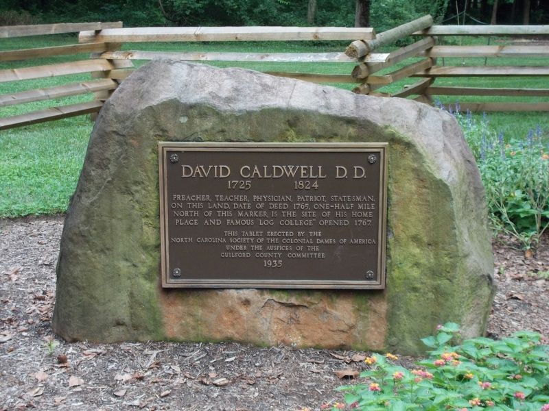
Preacher, teacher, physician, patriot, statesman. On this land, date of deed 1765, one-half mile north of this marker, is the site of his home place and famous "log college" opened 1767.
This tablet erected by the North Carolina Society of . . . — — Map (db m99803) HM
>Rachel, wife of David Caldwell and daughter of Alexander Craighead, is noted in history as one of the heroic women of the American Revolution. She is especially cited for bravery on this land, her home place, where the British encamped, and . . . — — Map (db m99800) HM
On North Main Street (U.S. 311) at East High Avenue, on the right when traveling north on North Main Street.
This marker commemorates the men and women who participated in The American Revolution. These patriots, believing in the noble cause of liberty, gallantly fought for their home and country. 1775 – 1783. — — Map (db m34746) WM
On West Main Street at East Parkside Drive, on the right when traveling west on West Main Street.
With 2400 British soldiers forded Deep River at this point and camped on its left bank, one mile up stream, prior to the Battle of Guilford Court House, March 15th, 1781. This battle was a determining factor in the establishment of American . . . — — Map (db m216810) HM
On State Highway 68, on the right when traveling north.
Troops of Cornwallis during American Revolution on way to Battle of Guilford Court House took over mill grinding meal for their men. Moved to present location and enlarged by Joel Saunders 1822 Commonly known as The Old Mill of Guilford Owned by . . . — — Map (db m87178) HM
On State Highway 68, on the right when traveling north.
Original water-powered mill built on nearby Beaver Creek to grind grain for early settlers. Reportedly seized by British troops prior to Battle of Guilford Courthouse. Mill moved downstream to current location and first waterwheel added 1818. . . . — — Map (db m87175) HM
On Oak Ridge Road (State Road 150) 0.1 miles east of Eversfield Road, on the right when traveling east.
James Gillies, Light-Horse Harry Lee's
teenage bugler, was killed near this spot by
Tarleton's British Dragoons February 12,
1781. Gillies accompanied a small posse of
Revolutionaries from a camp near present-
day Summerfield to verify reports . . . — — Map (db m234040) HM
On Summerfield Road south of Centerfield Road, on the right when traveling south.
• Appointed by provincial Congress to purchase firearms and ammunition for troops, April, 1776.
• Member of Halifax Congress, November, 1776. On committee of accounts. Recruiting officer, 1777.
• Member of House of Commons, 1782.
• State . . . — — Map (db m234115) HM WM
On Summerfield Road south of Centerfield Road, on the left when traveling south.
Revolutionary Leader
and Founder of Bruce's Cross Roads
(now Summerfield)
and
grave of James Gillies
Light Horse Harry Lee's Bugler
slain by British Feb. 12, 1781. — — Map (db m234035) HM
On North Carolina Route 481 east of Woodridge Road, on the right when traveling west.
Early Methodist Protestant minister; educator; and soldier in the Revolution. Founded Bradford's Church on this site circa 1792. — — Map (db m221527) HM
On U.S. 301 north of South King Street, on the right when traveling south.
The British Army under Gen. George Cornwallis marching to Virginia defeated the local Militia at the town of Halifax in May, 1781. — — Map (db m221535) HM
On King Street at Market Street, on the right when traveling north on King Street.
The market green played an important role in the growth and development of Halifax. The town’s original plan called for the green to take up both sides of King Street. In time, however, the courthouse, jail, and other public buildings occupied the . . . — — Map (db m222098) HM
On St David Street at Norman Street, on the left when traveling west on St David Street.
A militia officer during the Revolution; governor, 1798-99; envoy to France; "father" of University of N.C. Lived in this house. — — Map (db m226935) HM
On North Carolina Route 125, 0.7 miles south of Weatherbee Road, on the left when traveling south.
Brigadier general in the Revolutionary War, member of Provincial Congresses. Died, 1781, as British prisoner of war. Home was 60 yds. E. — — Map (db m221773) HM
On Mosby Avenue at East Warren Street, on the right when traveling north on Mosby Avenue.
In operation by 1770. Revolutionary tavern & stage stop. Named for family of Thomas Person. Restored by Littleton Woman's Club. One blk.E. — — Map (db m222015) HM
On U.S. 258, 0.1 miles north of Mary Chapel Road (County Road 1117), on the right when traveling north.
Colonel in Revolution. Member of Continental Congress, 1778-1781; of Provincial Congresses; and of state legislature. Grave 125 yds. S.E. — — Map (db m221571) HM
On North Carolina Route 24 east of Camron Hill Road, on the left when traveling east.
Scottish heroine, spent the winter of 1774-1775 at Mount Pleasant, the home of her half-sister, Annabella MacDonald, which stood 400yds. S.W. — — Map (db m219808) HM
On South Main Street (U.S. 401) north of East Front Street, on the right when traveling north.
Revolutionary War leader. Whig Colonel in Battle of Moore's Creek Bridge, 1776. Town of Lillington (est. 1859) named in his honor. — — Map (db m80520) HM
On West Cornelius Harnett Boulevard (U.S. 401) 0.5 miles west of North Main Street (State Highway 210), on the right when traveling east.
Revolutionary War statesman. Prominent in Resistance to British rule and the creation of North Carolina. Harnett County named in his honor, 1855. — — Map (db m30550) HM
On Pisgah Drive (North Carolina Route 110) at Jeffrey Lane, on the right when traveling north on Pisgah Drive.
This tree has witnessed several centuries of history, provided shade for nearby early Native American settlements, edged the trail of the Rutherford Trace march against the Cherokee, and served as a boundary marker before Haywood County was . . . — — Map (db m234881) HM
On Soco Road (U.S. 19) 0 miles east of Moody Farm Road, on the right when traveling west.
Revolutionary officer, member Congress, 1817-23, where, in "talking for Buncombe" (County), he gave new meaning to the word. Home was ½ mi. N. — — Map (db m11786) HM
On North Main Street (Business U.S. 23) at Depot Street, on the left when traveling north on North Main Street.
Erected to he memory of
the Revolutionary soldiers
buried in Haywood County
Colonel Robert Love • Captain John Henry • Private Thomas Abel • Private William Allen • Private George Hall • Private Edward Hyatt • Private Christian Messer • . . . — — Map (db m187454) WM
On Blue Ridge Parkway (at milepost 441.9), on the right when traveling south.
In 1776, Revolutionary War General Griffith Rutherford led 2,400 men through the gap below and to your left. During the war's early phases the Cherokee, with British support, repeatedly attacked the frontier settlements. Rutherford's expedition was . . . — — Map (db m123300) HM
In Honor of
Revolutionary Soldiers
Buried in
Henderson County
William Capps • John Peter Corn
William Senter • Joseoh Henry
James Johnson • Andrew Miller
Samuel King • Abraham Huymendall
James Brittaim • Jesse Richman . . . — — Map (db m241647) HM
On Red Springs Highway (State Highway 211) at Old Wire Road (County Road 1105), on the right when traveling south on Red Springs Highway.
Rendezvous point for local Tories. Near here on Sept. 1, 1781, David Fanning's men routed a Whig force under Thomas Wade. Stood 1.7 mi. W. — — Map (db m31257) HM
On Langtree Road (State Road 1102) at Mount Mourae Road, on the right when traveling west on Langtree Road.
where skirmish between British
and American soldiers occurred
February 1781.
Erected by
Mary Slocumb Chapter D.A.R.
1914.
Rededicated 2014 — — Map (db m237287) HM
On Centre Church Road (State Road 1245) 0.1 miles south of Fairview Road, on the right when traveling south.
The History of Centre Presbyterian Church Centre Church was organized in 1765 and held meetings at Osborne's Meeting House. This new congregation's mission was centrally located between five other missions: Sugar Creek, Hopewell, Fourth Creek . . . — — Map (db m237253) HM WM
On Mecklenburg Highway (State Road 115) at Langtree Road (State Road 1102), on the right when traveling south on Mecklenburg Highway.
British cavalry led by
Colonel Tarleton routed
a force of American
militia, Feb. 2, 1781,
at Torrence's Tavern,
which stood nearby. — — Map (db m237285) HM
On West End Avenue (State Highway 90), on the right when traveling west.
Dedicated by the Presbyterian church to the memory of the pioneers and to the soldiers of the Indian wars, the Revolution and the Confederacy who lie buried here.
Built by the pioneers, this wall was reconstructed by the national government and . . . — — Map (db m51803) HM
On West Vernon Avenue (Route 70/258), on the right when traveling east.
South of this tablet, 166 yards, is the grave of Richard Caswell, the first Governor of North Carolina, as an independent state. "I will most cheerfully join any of my countrymen, even as a rank and file man, and whilst I have blood in my veins . . . — — Map (db m30488) HM
On Old Lincolnton Crouse Road, 0.1 miles north of North Carolina Route 150, on the left when traveling north.
Burial site of Jacob Plonk (c.1747-1845)
Patriot of the American Revolution
His wife, Christina Kiser Plonk, son Joseph Plonk, his wife Barbara Rudisill Plonk, and Plonk, Hauss, Heafner, and Tutherow descendants. One of many early . . . — — Map (db m231840) HM
On Jeb Seagle Drive at Linwood Drive, on the left when traveling west on Jeb Seagle Drive.
After two hours, fighting ceased. As the fog lifted, the scene revealed the dead and wounded scattered on the ridge and flanks. About 100 men on each side were wounded and 50 Tories were taken prisoner. Casualties were heavy among officers. By . . . — — Map (db m231959) HM
On Jeb Seagle Drive at Linwood Drive, on the left when traveling west on Jeb Seagle Drive.
On the foggy dawn of June 20, 1780, Patriot Captains McDowell and Falls led their cavalry along the Tuckaseegee Road
towards the Loyalist camp. The horsemen advanced to within 30 yards of the Loyalist encampment before they were discovered, . . . — — Map (db m231956) HM
On Court Square at North Aspen Street, on the left when traveling west on Court Square.
Half a mile north from here was fought
The Battle of Ramsour's Mill
between the Whigs and Tories, June 20, 1780.
Colonel Francis Locke
Commanded the Whig Army — — Map (db m44386) HM
Near Jeb Seagle Drive, 0.2 miles north of Linwood Drive, on the left when traveling north.
By the spring of 1780 the war for America's independence, begun five years earlier in Massachusetts, had moved south. Following decisive victories in Georgia and South Carolina, the British army under the command of Lord Cornwallis was poised to . . . — — Map (db m44428) HM
Near Jeb Seagle Drive, 0.2 miles north of Linwood Drive, on the left when traveling north. Reported unreadable.
Buried here is Loyalist John Martin Shuford who died June 22, 1780 of wounds received in the Battle of Ramsour's Mill. His grave was originally marked with an old headstone and footstone. In 1997 the Lincoln County Historical Association and Shuford . . . — — Map (db m231966) HM
On Jeb Seagle Drive north of Linwood Drive, on the right when traveling north.
Tradition holds that buried at this brick enclosure are Patriot Captains John Dobson and John Bowman of Burke County, Dobson's daughter Nancy, and her husband Wallace Alexander. Dobson and Bowman were mortally wounded in the Battle of Ramsour's . . . — — Map (db m44398) HM
On Jeb Seagle Drive at Linwood Drive, on the left when traveling west on Jeb Seagle Drive.
After several years of war and a military stalemate in the northern colonies, the British took the war to the South. After capturing Charleston, South Carolina, on May 12, 1780, Lieutenant-General Charles, 2nd Earl Cornwallis eyed North Carolina as . . . — — Map (db m231949) HM
On State Highway 73 at Eastlake Lane, on the right when traveling west on State Highway 73.
In 1747 Adam Sherrill and his 8 sons migrated from Pennsylvania and settled west of the Catawba River. By July, 1749, John Beatty had also crossed the Catawba. Sherrill’s Ford (site underwater) and Beatty’s Ford (underwater) were named for them. . . . — — Map (db m156502) HM
On West Mills Road at Bryson City Road (State Highway 28), on the right when traveling south on West Mills Road.
Principal settlement of the Cherokee Middle Towns. Council house stood on mound 300 yds. S. Town destroyed during the Revolution. — — Map (db m203540) HM
On Catawba Avenue at North Railroad Street on Catawba Avenue.
Early outpost against Indians. Used by Gen. Rutherford in expedition against Cherokee, Sept., 1776. Stood nearby and gave name to this town. — — Map (db m208372) HM
On Beatties Ford Road (State Road 2074) north of McIntyre Avenue, on the left when traveling north.
In commemoration
of the
McIntyre Skirmish
Oct. 3, 1780
Erected by Mecklenburg Chapter
Daughters of the American Revolution
1901 — — Map (db m237493) WM
On Beatties Ford Road (State Road 2074) north of McIntyre Avenue, on the left when traveling north.
American forces:
14 men
Commander, Capt. James Thompson
Men:
George Graham, Lieut. • Francis Bradley • James Henry • Thomas Dickson • John Dickson • John Long • Robert Robinson • George Houston • Hugh Houston • Thomas McClure • Edward . . . — — Map (db m237502) HM WM
Near South Tyron Street north of East 3rd Street, on the right when traveling north.
From September 26 to October 12, 1780, the Southern British Army was encamped in Charlotte. The camp totaled about 4,000 people including officers, soldiers, loyalists, laborers, sutlers, and camp followers. The encampment was a square, about 400 . . . — — Map (db m95843) HM
On West 5th Street just west of North Church Street, on the right when traveling west.
A few days after the Mecklenburg Declaration of Independence and Mecklenburg Resolves were signed, Captain James Jack was deputized to deliver the words of liberty to the North Carolina delegates at the Continental Congress in Philadelphia. On . . . — — Map (db m175532) HM
On East Trade Street at North College Street, on the right when traveling west on East Trade Street.
Ephraim Brevard, raised near Charlotte, attended college in Princeton, New Jersey. He became a doctor, and later a teacher and trustee at Queen's College in Charlotte. He married Thomas Polk's daughter, Martha, and helped to write the Mecklenburg . . . — — Map (db m175599) HM
Near West 5th Street at North Church Street, on the right when traveling west.
The memory of
Revolutionary War soldier and patriot
Ephraim Brevard
Signer and reputed author of
the Mecklenburg Declaration of Independence, NC
Captain - NC
Battle of Moore' Creek Bridge - 27 February 1776
Surgeon 1st North . . . — — Map (db m175559) HM WM
On North Tryon Street at West Trade Street, on the right when traveling south on North Tryon Street.
One of Charlotte's founders - 1768. Headed militia during Revolution. This house was headquarters for General Cornwallis during British occupation Sept. 26 - Oct. 12, 1780. George Washington was entertained here May 28, 1791. — — Map (db m175604) HM
On West 5th Street just west of North Church Street.
You will see the hornets' nest as Mecklenburg's symbol in numerous places. Our reputation as a "hornet's nest" goes back to the Revolutionary War. On October 3, 1780, during British General Cornwallis' sixteen-day occupation of Charlotte, a . . . — — Map (db m175546) HM
On East Trade Street at South Tryon Street, on the right when traveling east on East Trade Street.
On the morning of the 20th day of May, in the year 1775, the patriots of Mecklenburg County declared themselves free and independent of Great Britain by signing the Mecklenburg Declaration of Independence which preceded the . . . — — Map (db m175511) HM
On West 5th Street at North Tryon Street, on the left when traveling east on West 5th Street.
You are standing where militia soldiers fought a delaying acting against the entire southern British army. For several months Col. William R. Davie had commanded the North Carolina militia cavalry, one of the few groups successful in keeping the . . . — — Map (db m175597) HM
On May 20, 1775, in a log courthouse near this spot, twenty seven patriot militia leaders debated and unanimously approved resolutions declaring themselves "free and independent” from Great Britain. known as the "Mecklenburg Declaration of . . . — — Map (db m173459) HM
On South Tryon Street just south of East Trade Street, on the right when traveling north.
From 1953 to 2012 this round marker was located in the middle of Trade and Tryon Street. It replaced an earlier marker dating back to at least 1909. It was relocated to this location in May 2012 so that it might be better known to the public. — — Map (db m175510) HM
On North Tyron Street at West Trade Street, on the left when traveling north on North Tyron Street.
Bold set of anti-British resolutions, adopted on May 31, 1775, in meeting 50 yds., S.W. organized by Thomas Polk, fired spirit of independence. — — Map (db m95844) HM
On West 5th Street just west of North Church Street, on the right when traveling west.
Colonel Thomas Polk (1732-1793), the great uncle of President James K. Polk, was one of Mecklenburg's first commissioners, a signer of the Mecklenburg Declaration of Independence, a delegate to the Continental Congress in 1786, and in 1791 hosted . . . — — Map (db m175555) HM
Near West 5th Street at North Church Street, on the right when traveling west.
Charlotte was established in 1768 by settlers who were, for the most part, Scots-Irish Presbyterians. In the first quarter of the nineteenth century, a church was built in "town" to be used by all denominations. Presbyterian minister John Thomson . . . — — Map (db m175561) HM
On South Tryon Street just north of East Martin Luther King Jr. Boulevard, on the right.
Site of
Liberty Hall
1777.
In honour of
the trustees of
Liberty Hall
Trustees
Isaac Alexander •
Thomas Polk •
Thomas Neal •
Abraham Alexander •
Waightstill Avery •
Ephraim Brevard •
John Simpson . . . — — Map (db m175508) HM
On South Tryon Street just south of 3rd Street, on the right when traveling north.
First tax supported college in Carolinas. Charter denied by King George III in 1782. Continued to operate as Queen's Museum and later as Liberty Hall Academy. Was an infirmary for British troops during Cornwallis occupation of Charlotte 1780. The . . . — — Map (db m175509) HM
On West 5th Street just west of North Church Street, on the right when traveling west.
After the fall of Charleston, SC, and the disastrous defeat at Camden, the British began to march inland to Charlotte. The only men left to defend Charlotte was a group of militia. Just before noon on September 26, 1780, the British entered . . . — — Map (db m175535) HM
On West 5th Street just west of North Church Street, on the right when traveling west.
On May 20, 1775, the citizens of Mecklenburg County declared themselves free from the rule of Great Britain by adopting the Mecklenburg Declaration of Independence. Each militia unit sent two representatives to the courthouse in Charlotte on May . . . — — Map (db m175530) HM
On South Tryon Street at West Trade Street, on the right when traveling south on South Tryon Street.
Thomas Polk (1732-1797), one of Charlotte's most prominent citizens within its formal years, was born in Pennsylvania. Like many of his fellow Scotch-Irish, he moved south on the Great Wagon Road, settling in Mecklenburg County about 1753.
A . . . — — Map (db m175516) HM
On Old Statesville Road (State Highway 115) north of State Highway 24.
May 20, 1775
Abraham Alexander, Chairman •
John McKnitt Alexander, Secretary •
Ephraim Brevard, Clerk
Hezekiah Alexander •
Ezra Alexander •
Adam Alexander •
Charles Alexander •
Waightstill Avery •
Hezekiah J. Balch • . . . — — Map (db m1579) HM
On W. Sugar Creek Rd. at N. Tryon St. (U.S. 29), on the right when traveling west on W. Sugar Creek Rd..
Patriot, Soldier, Statesman. Received nine wounds in Battle of Charlotte. Was left for dead on Sugaw Creek Road September 26, 1780. — — Map (db m126543) HM
On Providence Road (State Highway 16) south of Belicourt Drive, on the right when traveling south.
Encampment, Oct.-Dec. 1780, of N.C. militia & Continental Army, where Patriots laid plans to confront Cornwallis. Site was just west of here. — — Map (db m44935) HM
Near Providence Church Lane, 0.1 miles south of Providence Road (North Carolina Highway 16), on the left when traveling south.
Pvt under Col. Irwin & Col. Sumter, NC Line
Born in 1748; died Sept. 26, 1826 Mecklenburg County, NC
Exact location in cemetery unknown
Marker placed by Mecklenburg Chapter, NSDAR
2005 — — Map (db m237720) HM WM
Near Providence Church Lane, 0.1 miles south of Providence Road (North Carolina Highway 16), on the left when traveling south.
Pvt under Capts. McRee, Springs, and Polk
and Maj. Graham and Col. Thomas Polk
Continental Line, NC
Born March 10, 1757, died October 1, 1839
Marker by Mecklenburg Chapter, NSDAR
2001 — — Map (db m237734) WM
Near Providence Church Lane, 0.1 miles south of Providence Road (North Carolina Highway 16), on the left when traveling south.
Signer of the Mecklenburg
Declaration of Independence
Born May 5, 1728 in VA
Died October 8, 1798 in Mecklenburg Co.
Marker by Mecklenburg Chapter, NSDAR
2001 — — Map (db m237732) HM WM
Near Providence Church Lane, 0.1 miles south of Providence Road (North Carolina Highway 16), on the left when traveling south.
Pvt – NC Line
under Lt. Samuel Flennigan, Capts. Morrison, Springs, David Ruel,
Capts. Richard Simmons of calvary & John Harris of calvary,
Cols. Moore, Hagans
Lt. – NC Line
under Capt. James Osborne, Col. Robert Irwin,
Lt. – SC Line . . . — — Map (db m237733) HM WM
On Elizabeth Avenue at South McDowell Street, on the right when traveling east on Elizabeth Avenue.
In commemoration
of
the Battle of Charlotte
Sept. 26, 1780
Erected by The Battle of
Charlotte Chapter, Daughters
of the American Revolution
1918
“For God and my country I stand” — — Map (db m237675) WM
On Beatties Ford Road at Brown Mill Road, on the right when traveling north on Beatties Ford Road.
Cowan’s Ford, Catawba River where the Revolutionary Hero Gen’l. William Lee Davidson was killed in action Feb. 1, 1781 Born at Lancaster, Pa. 1746 -------•------- Davidson College Founded 1837 -------•------- Erected by Edward Lee Baxter . . . — — Map (db m63060) HM
On Beatties Ford Road north of Sample Road, on the right when traveling north.
To the memory of General William Lee Davidson of Mecklenburg County N.C. Born in 1746. Youngest son of George Davidson of Lancaster, PA. who moved to Mecklenburg Co., North Carolina, in 1750. Major 4th Reg. North Carolina Troops. Promoted . . . — — Map (db m63062) HM
416 entries matched your criteria. Entries 201 through 300 are listed above. ⊲ Previous 100 — Next 100 ⊳