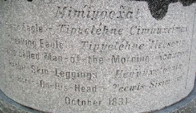
[Traveling?] approximately 2,000 miles from present-day Idaho, four Nimíipuu (Nez Perce) came to St. Louis in the fall of 1831 to the home of William Clark. Feeling pressure from an encroaching white presence in their homeland, these men . . . — — Map (db m62061) HM
On Park Drive, 0.1 miles north of Kehrs Mill Road, on the left when traveling east.
In honor and memory of those who served our country in war
Our honored dead
Ollie Helenkamp • Walter Lepere • Thurman Thompson • Harold Walka • Gregory Johnson • Thomas Shea • Thomas Foster — — Map (db m156708) WM
On Delmar Boulevard west of Limit Avenue, on the right when traveling east.
Already nicknamed "Senator" at Country Day High School, St. Louisan John Danforth was elected Missouri's Attorney General in 1968. He won a U.S. Senate seat in 1976 and for the next 18 years unified the Senate on difficult issues, including his . . . — — Map (db m124707) HM
American Attitudes Toward The Osage
In March 1804, the United States took possession of the Louisiana Territory, almost doubling the size of the United States. This provided growing space for an expanding population. The Lewis and Clark . . . — — Map (db m61396) HM
The small area (about 12 by 10 miles) where Osage Village State Historic Site is located, contains almost all of the Osage sites and early French and American sites relating to the Osage in Missouri.
1. Osage Village Site
The site on . . . — — Map (db m61407) HM
Built in 1908 as the University Library, this neoclassical building was Architect A. J. Gibson's fifth and final contribution to campus. In 1983 it was renamed in honor of 1902 graduate, suffragette and pacifist Jeannette Rankin (1880-1973). . . . — — Map (db m144098) HM
On East 1st Avenue (State Highway 16/5) 0.3 miles east of Lavalley Street, on the right when traveling east.
Sitting Bull was a great American Indian and Statesman. He struggled to keep his people free and united by fleeing with them into Canada. Louis Legare, a French trader and Sitting Bull’s friend, persuaded him to return to the United States and . . . — — Map (db m202834) HM
Near 3rd Street east of East Street, on the left when traveling east.
Chief Tecopa was a young man when the first white man came to Southern Nevada. As the leader of the Southern Paiute Tribes, he fought with vigor to save their land and traditional way of life. He soon realized, however, that if his people were to . . . — — Map (db m89415) HM
Near Marcy Street north of Puddle Lane, on the right when traveling north.
The Portsmouth Navy Yard was established in 1800 when the federal government perceived a need to expand the Navy in order to counter French privateer attacks against merchant shipping.
It has served varied functions over the years, first . . . — — Map (db m115967) HM
September 5, 1905 - A day now commemorated statewide as Portsmouth Peace Treaty Day - marks the signing of the Portsmouth Peace Treaty at the Portsmouth Naval Shipyard. The Treaty brought to a close the first great war of the twentieth century, . . . — — Map (db m76455) HM
Quakers settled Crosswicks in 1677 and purchased this land toward the end of that century. Friends have worshiped on this site continuously since that time. The smaller building was erected in the mid 1780's for use as a Quaker school and is now . . . — — Map (db m36084) HM
On Carranza Road, 4.4 miles Forked Neck Road/Bozarthtown Road, on the right when traveling south.
This monument commemorates the legacy and tragic accident of Captain Emilio Carranza Rodriguez, a Mexican aviator. Born in Ramos Arizpe, Coahuila, Mexico, Carranza was returning from a goodwill mission on a nonstop flight from New York to Mexico . . . — — Map (db m35139) HM
Near Whitney Avenue at Summit Lane, on the left when traveling west.
Hollybush was built in 1849 for industrialist Thomas Whitney. In 1917, the Italianate villa, located on the Whitney Estate, became part of the campus of the New Jersey State Normal School at Glassboro, now Rowan University. The house has served as . . . — — Map (db m222178) HM
Born June 19, 1856, in Wilkes-Barre, Pa.
He graduated third in the class of 1877 at Princeton University.
He served on the Trenton Board of Education (1894-1896); Trenton Common Council (1896-1900); Trenton Board of Trade (1896-1900); New . . . — — Map (db m4471) HM
On Morris Street, 0.1 miles east of Livingston Avenue (New Jersey Route 171), on the right when traveling east.
Planted in appreciation of the gift from the people of Tsuruoka, Japan, given in memory of the victims of 9/11 and as an expression of the friendship between New Brunswick and Tsuruoka.
New Brunswick and Tsuruoka signed a Sister . . . — — Map (db m208906) HM WM
Lifelong home of Commodore Lawrence Kearny, the sailor diplomat responsible for initiating relations between the United States and China.
Always known as "The Cottage'. Listed on the National Register of Historic Places. — — Map (db m93936) HM
Near Chesterfield Drive near New Jersey Route 24/513.
Dedicated to Those From the Chester Area Who Served in the Armed Forces of the United States of America.
With faith and courage they left their homes and committed themselves to the horrors of armed conflict, many sacrificing their lives as . . . — — Map (db m23021) HM
Near Lackawanna Avenue (County Route 632) at Westerholt.
On September 11, 1966, Rev. Dr. Martin Luther King, Jr. visited this site, the home of Rev. Dr. and Mrs. Deual Rice, after speaking at the celebration of Dr. Rice's retirement as Pastor of Union Baptist Church in Montclair. — — Map (db m78669) HM
On McNutt Road, 2.6 miles south of Racetrack Drive, on the right when traveling south.
[English Translation Marker:]
The first international monument of the 276 monuments installed to the west along the international land boundary which marks the international boundary between the United States and Mexico. This monument . . . — — Map (db m38105) HM
In commemoration of the mass for world justice and peace offered by His Holiness Pope John Paul II October 2, 1979 here in Yankee Stadium. Gift of the Knights of Columbus. — — Map (db m35059) HM
In commemoration of the solemn mass for peace offered by His Holiness Pope Paul VI October 4, 1963 here in Yankee Stadium. Gift of Knights of Columbus — — Map (db m183058) HM
Devoted his life to the pursuit of social justice
through non-violent civil disobedience,
beginning in South Africa, then as a leader of the
independence movement in his native India.
He was assassinated as he tried to address the . . . — — Map (db m197899) HM
On Cherry Street at West 3rd Street, on the right when traveling south on Cherry Street.
Robert H. Jackson United States Supreme Court Justice (1941 - 1954) and U.S. Chief Prosecutor at the international military tribunal at Nuremberg following World War II. Lived and worked in Jamestown for more than twenty years. From . . . — — Map (db m94836) HM
On East 4th Street at Prendergast Avenue (New York State Route 394), on the right when traveling west on East 4th Street.
[front] Robert H. Jackson 1892 - 1954. He kept the ancient landmarks and built the new. [right] "The very purpose of the Bill of Rights was to withdraw certain subjects from...political controversy. One's...fundamental rights may not be submitted . . . — — Map (db m94860) HM
The figure of the man and woman before you were cut from a larger section of the Berlin Wall. The section depicted above is located at the Winston Churchill Memorial and Library in Fulton, Missouri. Both works, the one here in Hyde Park and the . . . — — Map (db m210563) HM
Freedom Court commemorates the shared vision of two great warriors of
freedom: Franklin Delano Roosevelt and Winston Spencer Churchill.
During the dark days of World War II, they envisioned a future where
democracy and freedom would . . . — — Map (db m210565) HM
Near Nottingham Terrace, 0.2 miles east of Elmwood Ave.
Was originally conceived in 1970 with construction being completed in 1972. The purpose was to create a place of beauty and tranquility as well as commemorate the sister city relationship between Buffalo and Kanazawa, Japan.
In 1996 the garden was . . . — — Map (db m108503) HM
Near Erie Street, 0.5 miles north of Marine Drive.
This monument is dedicated to the Onodowaga or People of the Many Hills (Seneca). Shown are: The Hiawatha Wampum Agreement which brouht together the Five Nations in the pursuit of peace. A Seneca traditional gastowa or headress signified by the one . . . — — Map (db m92936) HM
On William Street at Starlite Avenue, on the right on William Street.
The defeated Indian League of the Iroquois received a large reservation across Erie County, at the end of the American Revolution. William Street forms part of the north boundary of this Buffalo Creek Indian Reservation. The final sale treaty, . . . — — Map (db m74063) HM
On Akron Road (County Route 11) at Gilmore Road, on the right when traveling west on Akron Road.
Son of William and Elizabeth Parker, born in a log cabin overlooking the water-falls, at Indian Falls, N.Y., then part of the Tonawanda Indian Reservation. Volunteered into the army, and became General Grant's Military Secretary. He was . . . — — Map (db m76082) HM
On Thompson Park east of Thompson Blvd., on the right when traveling east.
The 10th Mountain Division (Light Infantry) was reactivated at Fort Drum on February 13, 1985. By 1988, with the support of Fort Drum's world class civilian workforce, the Division was manned, equipped, trained and certified as combat ready, As the . . . — — Map (db m179340) HM
On Hanover Square north of Pearl Street, on the right when traveling north.
Located within the shady recesses of New York's financial district, this garden was commissioned by the British Memorial Garden Trust and given to the City in memory of the British and Commonwealth citizens who lost their lives during the attacks . . . — — Map (db m209653) HM
Near 12th Avenue (New York State Route 9A) at West 46th Street, on the right when traveling south.
Much like the aircraft carrier Intrepid, the submarine Growler was saved from the scrap yard by the dedication of a few very committed individuals.
Richard P. Torykian, who served in the U.S. Marine Corps in Vietnam, led the . . . — — Map (db m209768) HM
The first lady of The United States (1933 - 1945), as a political activist known for her unwavering support for human rights, lived here from 1959 to 1962. As a delegate to The United Nations (1946 - 1952), she chaired the commission that drafted . . . — — Map (db m152503) HM
On Second Avenue near East 47th Street, on the right when traveling south.
Council General of the United Nations
1953-1957
Noble Peace Prize
1961
(Illegible), negotiator, philosopher, public servant;
A man of true inner greatness in a position of leadership.
This building was dedicated to him on October 29, . . . — — Map (db m165310) HM
On Second Avenue south of East 47th Street, on the right when traveling south.
U.N. Secretary-General 1953-1961
Born in Jönköping Sweden 1905
Died at Ndola Africa 1961
The City of Jönköping and its Hammarskjöld Foundation honor his memory. — — Map (db m165619) HM
On Riverside Drive, on the right when traveling north.
This unique monument is a traditional Japanese stone lantern, dedicated in Sakura Park on October 2, 1960. The monument was a gift of international friendship, and its inscription (now worn away) read, “Presented by the . . . — — Map (db m96091) HM
On East Road east of Road 3, on the left when traveling south.
Four Freedoms
In January 1941 as Axis powers launched alarmingly successful assaults on three continents, FDR took the occasion of his eighth State of the Union address to warn Americans that their own way of life was in peril. In the . . . — — Map (db m204146) HM
On West Houston Street at Avenue of the Americas, on the right when traveling east on West Houston Street.
The City of New York acquired this property in 1925, and transferred it to the Department of Transportation as part of a Sixth Avenue renovation. The Board of Estimate later placed the parcel under NYC Parks jurisdiction in May 1934. The . . . — — Map (db m182949) HM
On First Avenue/United Nations Plaza near East 43rd Street, on the right when traveling north.
”Peace, to have meaning for many who have known only suffering in both peace and war, must be translated into bread or rice, shelter, health and education, as well as freedom and human dignity.”
-
Nobel Peace Prize Lecture 1950 . . . — — Map (db m165122) HM
On East 42nd Street at First Avenue/United Nations Plaza, on the left when traveling west on East 42nd Street.
"It is the future of the whole civilized world which is at stake."
Acceptance Speech as the United Nations Secretary-General, February 2, 1946
This plaza and sculpture honor Norwegian diplomat and humanitarian Trygve Lie, first . . . — — Map (db m165226) HM
On First Avenue at East 41st Street, on the left when traveling north on First Avenue.
Trygve Lie Plaza honors the memory of Norwegian statesman Trygve Lie (1896-1968), the first Secretary-General of the United Nations. The park was acquired by the City of New York in 1948 in connection with the widening of First Avenue and named for . . . — — Map (db m164750) HM
On Union Square West south of West 15th Street, on the right when traveling north.
"My optimism rests on my belief in the infinite possibilities of the individual to develop nonviolence in a gentle way you can shake the world."
Statue presented to the City Of New York and citizens of the United States of America
By Gandhi . . . — — Map (db m149480) HM
On West 81st Street at Columbus Avenue, on the left when traveling west on West 81st Street.
Founder of
the Nobel Prize
Swedish Inventor
Industrialist
Philanthropist
and Humanist
American Recipients of the Nobel Prize
1906 Theodore Roosevelt Peace •
1907 A.A. Michelson Physics . . . — — Map (db m226314) HM
On Center Street (New York State Route 18F) west of North 5th Street when traveling west.
June Tenth 1963
A peace plaque was established at the international boundary on the new Lewiston-Queenston Bridge by the Kiwanis Club of Lewiston, New York and the Stamford, Ontario Club. The plaque was unveiled by Richard H. Drake, left, . . . — — Map (db m82129) HM
On Whirlpool Street (New York State Route 182) at Ontario Avenue, on the right when traveling west on Whirlpool Street.
At this site stood the first Niagara suspension bridge. Built in 1848, that bridge and its three successors, have given one hundred years of uninterrupted service to the peoples of the United States and Canada, and have stood as monuments to the . . . — — Map (db m237073) HM
Near Scott Avenue north of Jackson Street (New York State Route 18F) when traveling north.
[Text from the Center Tablet]:
This Agreement Between the United States and Great Britain in Eighteen Hundred Seventeen has Assumed the Force of an International Treaty
The Naval Force to be maintained upon the . . . — — Map (db m67410) HM
On 2nd Street (County Route 370) at Sycamore Street, on the right when traveling west on 2nd Street.
Original lamp post in active use for nearly a century in Liverpool, England, presented by the people of that city to the residents of Liverpool, New York as a gesture of enduring friendship.
This gift made possible by Lord Mayor, Peter McKernan . . . — — Map (db m202546) HM
On State Street (U.S. 11) at Ononsaga Street, on the right when traveling south on State Street.
In central New York lies the Onondaga Country where the legendary Indian statesmen Hiawatha and Deganawidah planted The Tree of Peace, and this founded the Iroquois Confederacy of the Five Nations. Here burned the council fire of the League of the . . . — — Map (db m234363) HM
On Valentown Square east of High Street, on the right when traveling east.
Jane Burdette's eternal inspiration, optimism, and ability to foster collaboration are honored through the Jane C. Burdette & Valentine Family Memorial Art of Peace Garden. Displayed within a triangular design, heirloom plants for the Valentine's . . . — — Map (db m203730) HM
Near Boughton Hill Road (Route 41) at Victor Holcomb Road (New York State Route 444).
The Gayanessha'gowa, or Great Law, is the founding tradition of the League of the Haudenosaunee. The Great Law originated sometime between the tenth century, A.D., and the early sixteenth century. The League of the Haudenosaunee continues to meet . . . — — Map (db m126075) HM
Near Boughton Hill Road (County Route 41) at Victor Holcomb Road (New York State Route 444).
The Seneca call themselves Onondowahgah, People of the Great Hill. They are the western-most people of the Haudenosaunee, known today as the Six Nations Iroquois. Haudenosaunee means, "People who Build Houses," and the term has come to designate the . . . — — Map (db m126074) HM
Near Boughton Hill Road (County Route 41) at Victor Holcomb Road (New York State Route 444).
Jikonhasaseh was an elderly woman when the Peacemaker approached her to explain his mission to bring peace through reason to the nations of the world. She played a major role in the formation of the League of the Haudenosaunee. When the Peacemaker . . . — — Map (db m126505) HM
Near Washington Street, on the right when traveling east.
This monument was erected under the authority of the Congress of the United States and of the State of New York in commemoration of The Disbandment under proclamation of the Continental Congress of Oct 18, 1783 of the Armies by whose patriotic & . . . — — Map (db m8205) HM
Near Howard Road, on the left when traveling north.
The hand of the aggressor is stayed by strength - and strength alone. Dwight David Eisenhower [ Lower Marker : ] The words inscribed on the tablet above are from a speech made in London in 1951. Presented by the Class of 1942 in memory . . . — — Map (db m50149) HM
On East 1st Street (New York State Route 481) north of East Mohawk Street.
Near this site, on May 5-7, 1814, British naval forces entered Oswego Harbor and conducted an amphibious assault on Fort Ontario and the Village of Oswego. Lieutenant Colonel George Mitchell, commanding 290 men of the 3rd U.S. Artillery Regiment and . . . — — Map (db m86211) HM
On East 1st Street (New York State Route 481) north of East Mohawk Street, on the right when traveling south.
The thriving port city of Oswego was founded by and attracted many ambitious and heroic people. Leaders of industry and social causes lived here and left their mark on the city. You can still visit some of their works by touring the city streets . . . — — Map (db m86292) HM
On Avenue of the States north of United Nations Avenue South, on the right when traveling north.
Dedicated toward man's aspirations to Peace Through Understanding and symbolizing his achievements in an expanding universe.
Built and presented by the United States Steel Corporation (USS) to the New York World's Fair April 22, 1964. . . . — — Map (db m239572) HM
On Avenue of Africa north of United Nations Avenue South, on the left when traveling north.
Dedicated toward man's aspirations to Peace Through Understanding and symbolizing his achievements in an expanding universe.
Built and presented by the United States Steel Corporation (USS) to the New York World's Fair April 22, 1964. . . . — — Map (db m239573) HM
On Avenue of the Americas south of United Nations Avenue North, on the right when traveling south.
Dedicated toward man's aspirations to Peace Through Understanding and symbolizing his achievements in an expanding universe.
Built and presented by the United States Steel Corporation (USS) to the New York World's Fair April 22, 1964. . . . — — Map (db m239574) HM
Near Livingston Street at Oak Tree Road, on the right when traveling south.
Commemorating the 200th anniversary of the meetings between General George Washington and General Sir Guy Carleton at Tappan and aboard H.M.S. Perseverance. Jointly by the Historical Society of Rockland County and Tappantown Historical Society. . . . — — Map (db m7291) HM
On New York State Route 89, 0.3 miles Cemetery Road, on the right when traveling south.
Red Jacket
was born here about 1758.
The famous Indian orator
and Seneca Chief sought to
preserve peace with U.S.
Died in Buffalo in 1830. — — Map (db m8181) HM
On Water Street west of Hamilton Street (New York State Route 417), on the left when traveling west.
Col. Timothy Pickering, commissioner appointed by President Washington, negotiated the Treaty of Painted Post with the Iroquois Indians, which ended warfare between the Six Nations and the white settlers in New York State.
Dedicated: June 11, . . . — — Map (db m91059) HM
On Hurd Road at West Shore Road, on the right when traveling north on Hurd Road.
This is the original site of the Woodstock Music and Arts Fair held on Aug 15, 16, 17, 1969.
Peace and Music Wayne C. Saward sculptor
On Stage Performers. Richie Havens, Arlo Guthrie; Joan Baez; Joe Cocker; Ravi Shankar; Janis . . . — — Map (db m18323) HM
On Railroad Place, 0.1 miles east of Main Street, on the left when traveling east.
Citizen Soldier
“I waved my hat and went up the hill with a rush.” In 1898, Roosevelt resigned as Assistant Secretary of the Navy, volunteered for service in the Spanish-American War and became Lieutenant Colonel of the 1st United . . . — — Map (db m138518) HM
At this site stood a magnificent oak tree under which, according to tradition, in A. D. 1645 Aepjen, chief sachem of the Mohegans, signed a treaty of peace with the Dutch in behalf of the Kitchiwanghs — — Map (db m126257) HM
Near Council Grounds Access Road, 0.2 miles west of Park Road.
[front]
To the Memory of Mary Jemison, Whose home during more than seventy years of a life of strange vicissitude was among the Senecas upon the banks of this river, and whose history, inseparately connected with that of this valley has caused . . . — — Map (db m76359) HM
Near Council Grounds Access Road, 0.2 miles west of Park Road.
William Pryor Letchworth first became interested in Native American culture after hearing his father's stories about Cornplanter, the Seneca Chief, meeting with Letchworth's great-uncle, John Letchworth, a Quaker preacher in Philadelphia. Sensitive . . . — — Map (db m76005) HM
On Letchworth Park Road, 0.9 miles south of Schenck Road (County Route 18), on the left when traveling south.
North border of reservation set aside for Mary Jemison White Woman of the Genessee during the Big Tree Treaty of 1797 at Geneseo N.Y. — — Map (db m118841) HM
Near East Lexington Avenue just west of Terrell Drive, on the right when traveling west.
This tree was planted on August 26th 1984 by The Friendship Force of Guilford, U.K. to celebrate their exchange with Guilford County, and to mark the 400th anniversary of the first British colony in North Carolina. — — Map (db m175470) HM
On 8th Avenue at 3rd Street, on the right when traveling west on 8th Avenue.
In a 1974 North Dakota State University interview-poll of long-time residents, newcomers, and local officials, four out of five respondents indicated that the overall effect of the Safeguard project had been beneficial in terms of the . . . — — Map (db m214104) HM
On 113th 1/2 Avenue Northeast near 113th Avenue Northeast (State Route 45), on the left when traveling north.
Ronald Reagan Minuteman Missile State Historic Site — Oscar-Zero Missile Alert Facility
You are on the access road to Oscar-Zero- one of 15 Missile Alert Facilities (MAF) of the
321st Strategic Missile Wing (SMW) of Grand Forks Air Force . . . — — Map (db m176534) WM
On Railway Street just south of 2nd Avenue, on the left when traveling south.
Born near Hatton, ND May 19, 1896. 1915 — Mayville State College graduate. Enderlin Educator — 20 years. 1918 — Worked for women’s suffrage with League of Women Voters. 1935 — President of ND American Legion Auxiliary. 1946-1954 — First female ND . . . — — Map (db m213991) HM
On South Shafer Street, 0.1 miles east of Richland Avenue, on the left when traveling east.
Presented by President Kazuo Yamada Chubu Institute of Technology
In honor of the 175th anniversary of Ohio University and in recognition of the exchange program between Chubu Institute and Ohio University September 14, 1979 — — Map (db m189701) HM
On South Shafer Street, 0.1 miles east of Richland Avenue, on the left when traveling east.
The blossoms of Ohio University's iconic cherry trees symbolize the arrival of springtime in Athens. The trees serve as a living commemoration of the University's longest institutional partnership, with Chubu University, located in Kasugai, . . . — — Map (db m189699) HM
On U.S. 33 at Ohio Route 65, on the left when traveling east on U.S. 33.
Nearby sleeps Chief (Blackhoof) Catahecassa, last principle chief of the Shawnees prior to their removal to Kansas in 1832. This was Blackhoofs town where he lived and died in Sept. 1831, at the age of 109. He fought with the French against Braddock . . . — — Map (db m16971) HM
On North Chestnut Street at East Spring Street (Ohio Route 29/66), on the right when traveling north on North Chestnut Street.
Members-at-large:
Ray Barber • Wanda Dammeyer • Arnold Meckstroth • Ray Schmidt • Eva Sell • Elois Wierwille
Charter members of SMLFO:
Deanna Barber • Ray and Jan Barber • Patricia Barber • Dr. Paul and Holly Blaine • Mr. . . . — — Map (db m232772) HM
On East Auglaize Street just east of Willipie Street, on the right when traveling west.
1994-2014
In Memory of celebrating the 20th anniversary of the German-American Sister Cities friendship between Wapakoneta/Ohio and Lengerich/Germany
Bringing the world together through education and cultural exchange . . . — — Map (db m237657) HM
First Jain Temple in Ohio
"Souls render service to one another"
The Jain Center of Cincinnati and Dayton was established on April 22, 1979 as a non-profit tax-exempt organization under the laws of the United States and the State of Ohio. . . . — — Map (db m24073) HM
On Monument Avenue at High Street (Ohio Route 129/177), on the right when traveling south on Monument Avenue.
Side A: Soldiers, Sailors, and Pioneers Monument
The Soldiers, Sailors, and Pioneers Monument was planned and promoted by Butler County Civil War veterans and financed by a county levy in 1899. The monument, built of Indiana Limestone, is . . . — — Map (db m30705) HM
On Okeana-Drewersburg Road, 0.1 miles west of Cincinnati-Brookville Road (Ohio Route 126), on the right when traveling west.
Side A:
1858 Morgan Township House
On April 20, 1857, the trustees of Morgan Township met in Okeana to obtain a lot for the township house. From a quarter mill tax levy, $850 was budgeted for a house and lot. Money expended on the project . . . — — Map (db m24000) HM
On E Main Street (U.S. 40) at S Spring Street (Ohio Route 72), on the left when traveling west on E Main Street.
This Marks the Site of
The First Tavern in Springfield
Near Which
In 1808 A Permanent Peace Treaty
Was Made By
Simon Kenton and Others
With the Indians — — Map (db m217174) HM
“One day while plowing I heard a voice,”
whether inside me or outside of me I knew not,
but I was awake.
It said, ‘Go thou and see the president.’
I answered, ‘Yea, Lord, thy servant heareth.’
and unhitching my plow, I went . . . — — Map (db m28002) HM
776 entries matched your criteria. Entries 301 through 400 are listed above. ⊲ Previous 100 — Next 100 ⊳