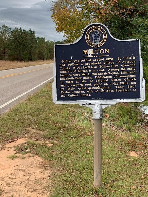
On Autauga County Road 1, on the right when traveling north.
Milton was settled around 1829. By 1840 it had become a prominent village of Autauga County. It was known as "Milton City” when the 1886 flood buried it in sand. Among the early families were Wm. L. and Sarah Taylor. Elihu and Elizabeth Parr Bates. . . . — — Map (db m209092) HM
On Dixie Graves Highway, on the right when traveling south.
At, or near, this site, the United States, after seizing this point of land from the Spanish in 1813, built Fort Bowyer, a structure of wood and sand.
A small garrison of men courageously fought to defend the fort against two British attacks, one . . . — — Map (db m187339) HM
On County Road 47 0.4 miles east of Interstate 65, on the right when traveling east.
"Alabama's First Farm Winery Since Prohibition"
A 50 acre Muscadine Grape Vineyard was established
at this site in 1972 to produce grapes for Bartels
Winery of Pensacola, Florida. In 1979, legislation
sponsored by Rep. John M. McMillan . . . — — Map (db m122470) HM
On Cotton Avenue at Highland Avenue on Cotton Avenue.
The Tree That Owns Itself
Planned and Dedicated
April 19, 1961
Replacing the Walker Oak
Felled by Wind April 9, 1961
Original Deed Granted by
City of Eufaula
to the
Post Oak Tree
April 8, 1936 . . . — — Map (db m101286) HM
On Main Street (Alabama Route 51), on the right when traveling south.
Cast in 1889 to commemorate the Town of Louisville Fire Department, this fire bell was located on top of the well house near the ball field. The ringing of the bell alerted volunteers of a fire.
This bell was re-installed and dedicated at . . . — — Map (db m190965) HM
On 6th Street South (U.S. 231) at Champion Road, on the right on 6th Street South.
John Hanby came in 1817 and found a rich seam of brown iron ore. Named Champion in 1882 when Henry DeBardeleben and James Sloss bought land and brought L&N Railroad causing county seat to be moved from Blountsville to Oneonta in 1889. Most ore was . . . — — Map (db m28362) HM
On Old Broadway Street (U.S. 82) at Main Street, on the right when traveling west on Old Broadway Street.
Drill Ground of the Midway Guards 1860, later Company B 15th Alabama C.S.A. ordered to Richmond. Second Company 1861 assigned to Company C 45th Alabama C.S.A. ordered to Army of Tennessee. These and many later volunteers met the enemy in . . . — — Map (db m89636) HM
On Ridge Road (County Road 54) at Crenshaw Road, on the right when traveling north on Ridge Road.
Dr. John Coleman, born June 6, 1788 in North Carolina, was one of Butler County's earliest pioneer settlers. He built the Coleman-Crenshaw House some time between 1817 and 1821. In June 1820 the first election for Sheriff and Constable, held in . . . — — Map (db m130052) HM
On McCullars Lane west of County Road 73, on the left when traveling west.
This stone marks the site of the Tallasahatchie Battle Field. On this spot Lieut. Gen. John Coffee with Gen. Andrew Jackson's men won a victory over the Creek Indians, Nov. 3, 1813. — — Map (db m36554) HM
On Public Square East (State Highway 21) north of Ladiga Street Southeast, on the left when traveling north.
Selected as a landmark contributing to a deeper
understanding of our American Heritage.
Entered on
The National Register of Historic Places
by the
United States Department of the Interior
May 13, 1986
Centered around Jacksonville’s . . . — — Map (db m36479) HM
On North Center Avenue at Southern Blvd, on the right when traveling south on North Center Avenue.
Cross Plains citizens voted for incorporation March 10, 1871. A second vote was cast for reincorporation May 15, 1882. By the acts of the Alabama Legislature of 1888, Cross Plains became Piedmont September 30, 1888. Mayors for both Cross Plains and . . . — — Map (db m272390) HM
On B Street at 1st Place SW, on the right when traveling north on B Street.
Vines Funeral Home and Ambulance Service was established in 1952
and is representative of a mid-20th century rural African American
funeral home. It is the only funeral home in Alabama still operating
an ambulance service. The main building of . . . — — Map (db m151221) HM
On Alabama Route 273 at County Route 275, on the right when traveling south on Alabama Route 273.
Gen. Hood, commanding the Dept. of Tennessee and Georgia for the Confederate Army, made his headquarters in this house on Oct. 19, 1864 on his retreat from Atlanta to Tennessee via Gadsden. His army numbered approximately 40,000 troops. — — Map (db m116615) HM
On East Main Street (Business U.S. 411) at Cedar Bluff Road, on the left when traveling east on East Main Street.
In November 1958, Col. Robert E. Mann and a small group of interested residents organized the Cherokee County Historical Society in Cedar Bluff with a goal to initiate the preservation of the history of Cherokee County. Over the following years, the . . . — — Map (db m261855) HM
On County Road 63 0.8 miles north of State Route 143, on the left when traveling north.
This ship's mast flagpole is an aluminum replica of the original wooden Soldiers' Home flagpole which stood in front of Memorial Hall (approximately 25 yards southwest of this spot).
High above [Memorial Hall] towered a long and graceful . . . — — Map (db m129420) HM
On County Road 63 0.7 miles north of State Route 143, on the right when traveling north.
This is the site of Alabama's only Confederate veterans' home. The Alabama Confederate Soldiers' Home operated for 37 years as a haven for many of Alabama's destitute Confederate veterans and their wives or widows.
Twenty two buildings once . . . — — Map (db m129359) HM
On County Road 63 0.7 miles north of State Route 143, on the right when traveling north.
The Alabama Confederate Soldiers' Home was a self-sufficient operation. Constructed in 1904 by the State of Alabama, the reservoir and pumping stations were part of an intricate system which replaced hand dug wells as the main source of fresh water. . . . — — Map (db m130091) HM
On College Avenue (Alabama Route 177) at Ocre Avenue, on the right when traveling south on College Avenue.
Just west of this spot, along Ocre Ave. on a 10-acre tract, was the site of a WWII prisoner of war camp. The camp was one of twenty such labor camps in Alabama. Hdqrs. for the camp was at Camp Shelby in Hattisburg, MS. The camp was opened on . . . — — Map (db m101593) HM
On Alabama Route 69 at Bolen Town Road, on the right when traveling south on Alabama Route 69.
The area from Stave Creek to Jackson Creek was one of sites for the making of salt during the years 1862-64.
Furnaces of native stone were built and salt water from dug wells evaporated by boiling in large kettles.
Amount of salt six hundred . . . — — Map (db m101607) HM
On Wilson Dam Avenue at Pickwick Street on Wilson Dam Avenue.
In 1918, during World War I, the U.S. Government built this unique village of 85 bungalows, school, and officers barracks to house personnel at nearby Nitrate Plant No. 1. Prefabricated and standard size materials were used in construction along . . . — — Map (db m88110) HM
On North Dickson Street at East 3rd Street, on the right when traveling north on North Dickson Street.
This congregation was organized in the 1830's, with services being held in private homes and the Methodist meeting house. The present building was first used in October 1852 and completed the following year. During the Civil War, Union troops . . . — — Map (db m28422) HM
On County Road 5 0.7 miles south of County Road 2, on the right when traveling north.
Garrett Longmire had an early trading center, tavern and stage stop near here. He served as the postmaster when his store became a post office in 1818, one of the earliest in what was then the Alabama Territory. The Burnt Corn Post Office served as . . . — — Map (db m81298) HM
On Oak Street 0.2 miles 2nd Street North, on the left when traveling north.
Two-story brick slave quarters like the
one before you were not typical, but they
could be found in wealthy towns like
Cahaba.
Stephen Barker built these brick quarters
and a fine brick home for himself in
1861 on the northern edge of . . . — — Map (db m150865) HM
In 1862 the Confederacy used one of
Cahawba's brick cotton warehouses to
temporarily house men captured at the
Battle of Shiloh. In 1863, they officially
converted the warehouse into a military
prison. The inmates called it "Castle . . . — — Map (db m112528) HM
On Capitol Street, on the right when traveling east. Reported permanently removed.
This structure collapsed in 1833 and its fallen remains were reportedly heaped into a railroad embankment. Consequently, we have no picture of the Statehouse that was drawn by someone who actually saw the building. Any modern picture you see of this . . . — — Map (db m75909) HM
On Gault Avenue South (U.S. 11) at 2nd Street SW, on the left when traveling north on Gault Avenue South.
The Fort Payne Main Street Historic District developed between 1889 and the 1940s, because of the city's rapid growth during the hosiery mill industry boom. The increased population needed new commercial and governmental buildings, which were . . . — — Map (db m100028) HM
On this site during the mid 1900's stood what was known to locals as
Whittler's Corner
Folks would gather most any day to whittle, exchange gossip, talk politics, preach and most of all just pass time with friends. A large stump was where . . . — — Map (db m224650) HM
Near Persimmon Street at St. Nicholas Avenue ( Route 41).
Side 1
This tank was used to hold water for the City of Brewton Electric Light and Water Works Fire Protection System and was built circa early 1890's. This location was originally the Blacksher Miller Lumber Company, which became . . . — — Map (db m94172) HM
On Damascus Road at Well Road (County Route 71), on the right when traveling east on Damascus Road.
Damascus Travelers Well (construction date unknown) was originally a public water well offering refreshment and rest for travelers and their animals passing through this area. The Damascus community also benefited from this well. Mr. and Mrs. N. W. . . . — — Map (db m130668) HM
On 6th Avenue at 4th Street NW, on the right when traveling north on 6th Avenue.
In 1851 twelve Methodists met in Newton (later Attalla) to plan a Methodist Episcopal Church. A crude log building on North Fifth Street served as the first church. In 1861 and again in 1882 the church relocated on Fifth to accommodate the growing . . . — — Map (db m83731) HM
On Marston Ave at Coolidge Circle, on the right on Marston Ave.
Dwight Manufacturing Company of Chicopee, Massachusetts selected this site in Alabama City for a cotton mill in 1894. The Mill and the village covering 240 acres was constructed under the direction of Howard Gardner Nichols.
There were 160 . . . — — Map (db m18575) HM
On Forrest Avenue at South 8th Street, on the right when traveling east on Forrest Avenue.
Created by state legislature on December 1, 1868 from territory taken from Cherokee, DeKalb, Marshall, Blount, St. Clair and Calhoun Counties, having originally been formed December 7, 1866 as Baine County in honor of Confederate hero David W. . . . — — Map (db m83735) HM
On South 1st Street at Broad Street (U.S. 411), on the right when traveling north on South 1st Street.
Side A:
In the early 1840’s, John S. Moragne, along with Gabriel and Joseph Hughes, began surveying for a city on the banks of the Coosa River near the settlement of Double Springs. The new city would be located on 120 acres of land at the . . . — — Map (db m39139) HM
On 4th Avenue SE, on the left when traveling west.
Side A Red Bay is nestled in the northwest corner of the state in Franklin County. The oak trees, planted by the Garden Club in 1937, issue a Main Street welcome through the “tunnel of trees.” Originally inhabited by Chickasaw . . . — — Map (db m41133) HM
Side A One of the Five Lower Towns established by the Chickamauga Cherokees in 1782 under the leadership of Dragging Canoe. Territorial Governor William Blount reported to the Secretary of War in 1792 that: “Crow Town lies on the north . . . — — Map (db m28473) HM
Near 3rd Avenue North near Richard Arrington Jr, Blvd North.
To Be Opened March 1, 2022
Dedicated at the construction completion March 1, 2002
Project Team
Owners - BLH Group, LLC
Brookmont Investors II, LLC
Spire Holdings, LLC
Developer - Brookmont Realty Group, LLC
General . . . — — Map (db m27010) HM
Near 1st Avenue North (U.S. 11) near 32nd Street North.
The crossing of railroads in 1872 adjacent to this site gave rise to the industrial city of Birmingham. In 1881 Alabama railroad magnate and entrepreneur James Withers Sloss, capitalizing on the unusual coincidence of coal, iron ore and limestone in . . . — — Map (db m23498) HM
On Vulcan Road north of Richard Arrington Jr Boulevard South, on the right when traveling west.
Vulcan Park isn’t just Vulcan’s home; it’s also a public park. The original project, funded by the WPA (Works Progress Administration) aimed for “general beautification of the entire acreage” to create” an ideal spot for untold scenic beauty.” The . . . — — Map (db m69015) HM
On 20th Street South at 11th Avenue South, on the right when traveling north on 20th Street South.
This neighborhood developed in the 1880s as one of Birmingham's first streetcar suburbs. It was the Town of Highlands from 1887 to 1893, when it became part of the City of Birmingham. The heart of the neighborhood was Five Points Circle, a major . . . — — Map (db m83829) HM
The Brock building was established in 1915, located at the intersection of Fourth Avenue and 18th Street North, was built while the area was residential. The three-story building housed a hotel upstairs that catered to professional musicians and . . . — — Map (db m26723) HM
Near 5th Avenue North at 16th Street North, on the right when traveling east.
This sculpture is dedicated to the Foot Soldiers of the Birmingham Civil Rights Movement.
With gallantry, courage and great bravery they faced the violence of attack dogs, high powered water hoses, and bombings. They were the fodder in the . . . — — Map (db m27394) HM
On Arlington Avenue at Aberdeen Road, on the right when traveling south on Arlington Avenue.
Extending across the crest of Red Mountain, is the state’s second oldest garden-landscaped residential area. Developed from 1911 to 1935 by Robert Jemison, Jr., Hill Ferguson, and Henry Key Milner using landscape architects C. W. Leavitt of New York . . . — — Map (db m41129) HM
On 12th Street Southwest at 1st Court West, on the right when traveling north on 12th Street Southwest.
Built by Birmingham industrialist A. H. “Rick” Woodward, Rickwood Field served as home to the Birmingham Barons and Birmingham Black Barons for most of the 20th century. Recognized as “America’s Oldest Baseball Park,” . . . — — Map (db m83837) HM
On 1st Avenue North (U.S. 11), on the right when traveling north.
The Creek Indian Cession of 1814 opened this section of Alabama to settlement. At the time of statehood in 1819 many pioneer families had located here in what later became known as Jones Valley. By 1820 the area was called Ruhama Valley as a result . . . — — Map (db m26680) HM
On Cumberland Drive east of 4th Avenue South, on the right when traveling east.
Roebuck Springs was the first large residential suburb in Birmingham where planning and development were tied to the automobile, and the first community in the city associated with a golf course development. The 1910 land plan was designed to . . . — — Map (db m26684) HM
On Cumberland Drive at Balcourt Drive, on the right when traveling east on Cumberland Drive.
Wilson Chapel was built in 1916 as a memorial to James and Frances Wilson by their daughters, Rosa Wilson Eubanks and Minerva Wilson Constantine. At the time of its construction the area was developing into a community of country homes known as . . . — — Map (db m26681) HM
On 1st Avenue South at 28th Street S, on the right when traveling south on 1st Avenue South.
Seaboard Yard is a unique, award winning, mixed use, live-work project developed in 2005-2008 by Liz & Cory Mason John Lauriello, Bryan Holt and Julie Gieger.
The historic 35 acre site was once the home of the Seaboard Railroad's Birmingham . . . — — Map (db m220598) HM
On 29th Avenue South at 18th Street South, on the right when traveling west on 29th Avenue South.
Side A Located in Jefferson County in Shades Valley, Homewood came into existence with the combination of Edgewood, Rosedale, and Oak Grove. Hollywood, a fourth community, joined Homewood later. The City of Homewood was incorporated in 1926, . . . — — Map (db m37712) HM
On Wisteria Drive at Monte D'Oro Drive, on the left when traveling west on Wisteria Drive.
A neighborhood of 158 homes, Monte D'Oro was established July 23, 1964, which was prior to the incorporation of the City of Hoover. The neighborhood was build by developer William M. "Bill" Humphries. These homes were designed by architect and . . . — — Map (db m83253) HM
On Shades Crest Road east of Mimosa Lane, on the right when traveling east.
Indian, Wagon Trail, now Shades Crest Road, led to popular chalybeate springs. Summit, now Bluff Park, was a resort known for its view, cool air and healing mineral water. In 1899 school / church was built. In 1909 Bluff
Park Hotel, built on land . . . — — Map (db m28517) HM
On Lee Highway (U.S. 72) 0.7 miles west of County Road 583, on the left when traveling west.
Daniel White, native of North Carolina, purchased land here in 1818, a year before Alabama became a state. His home and stagecoach stop, "Wayside Inn" was a large two~ story log house located on the North side of the highway from this site. In 1834 . . . — — Map (db m29170) HM
The notorious outlaw gang leader who boasted that no one would ever run over Tom Clark lies buried near the center of Tennessee Street where now all who pass by do run over him. In 1872, Clark, who terrorized helpless citizens during the Civil War, . . . — — Map (db m80320) HM
Placed on the National Register of Historic Places in 1997, this district contains 52 structures, most of which were built after 1900. Cherry Street was laid out in 1818 near the east boundary of Florence. Pulitzer Prize winner Thomas Sigismund . . . — — Map (db m28406) HM
On South Court Street at East Tennessee Street ( Route 2), on the right when traveling north on South Court Street.
From the time Florence was established in 1818, a slow but steady growth occurred. In the late 1880s the town's population increased by 500 percent as an industrial boom began. This area became the core of the business district. Most of the . . . — — Map (db m35177) HM
Near Hightower Place south of Veterans Drive ( Route 133), on the left when traveling south.
Dr. E. B. Norton was a member of the U.S. Education Mission sent to Japan after World War II to advise Gen. McArthur on the complete reorganization of the Japanese School System, which is still in place today. — — Map (db m219325) HM
Side A This area near the mouth of Cypress Creek was inhabited by Archaic People as early as 8,000 B.C. Their main food consisted of freshwater mollusks from the river.
(These mussels were the origin of the name "Muscle Shoals.")
The . . . — — Map (db m84044) HM
On Veterans Park Drive at South Cox Creek Parkway ( Route 133), on the left when traveling south on Veterans Park Drive.
In the late 1960s, Point Park was developed by the City of Florence on this 82-acre site, leased from TVA, for outdoor recreation. It was the first multi-use sport complex in the State of Alabama. In the early 1970s, plans were developed for a . . . — — Map (db m74407) HM
On North Walnut Street near East Tuscaloosa Street.
Walnut Street began as a residential area in the national economic boom of the 1880s and 1890s and continued its development through the 1920s. Industries and businesses grew in Florence, the population of the city increased, and business and . . . — — Map (db m84158) HM
Lock Six, headquarters of Muscle Shoals Canal, was located 1.3 miles south of here. An 1836 attempt to build a bypass canal around the shoals proved unsuccessful. On November 10, 1890 the canal from Rogersville to Florence was successfully . . . — — Map (db m28452) HM
On McLean Drive 0.7 miles south of U.S. 72, on the right when traveling south.
Camp Drake Boy Scout Camp. Camp Drake was located within the current Joe Wheeler State Park Day Use Area. Camp Drake Reservation hosted Black Boy Scouts of the Tennessee Valley Council (TV) for annual summer camps and other events. A . . . — — Map (db m288540) HM
On Lauderdale County 14, on the right when traveling west.
One of Alabama's oldest incorporated towns. Waterloo was an important Tennessee river port during the steamboat era. In low~water season after large boats from Louisville, Cincinnati and other places downriver unloaded here: smaller craft . . . — — Map (db m84302) HM
Near County Road 187, on the right when traveling east.
Five Historic Indian tribes lived in this area. By 1701, The Yuchi were living at the shoals on the Tennessee River. In early 1700s the Yuchi left, some moving to the Cherokee Nation on the Hiwassee River, TN and others to Chattahoochee River, GA. . . . — — Map (db m36040) HM
On Birmingham Highway (U.S. 280) at North College Street (State Route 147), on the right when traveling south on Birmingham Highway.
Built in 1924 and billed as "the world's largest bottle", The Bottle (also know as the "Twist Inn") was built by John F. Williams, owner of the Nehi Bottling Company in Opelika, Alabama. A wooden replica of a bright orange Nehi soda bottle, it stood . . . — — Map (db m85167) HM
On North College Street at West Magnolia Avenue, on the right when traveling south on North College Street. Reported missing.
This famous intersection, now known as Toomers Corner was named for businessman and State Senator Sheldon Toomer who founded the Bank of Auburn here in 1907. He served 45 years as bank President and 25 years on the Auburn City Council. Toomers . . . — — Map (db m183930) HM
On Lauderdale Street at East Street (County Road 71), on the left when traveling east on Lauderdale Street.
On this day, Mooresville, the first town incorporated by the Territorial Legislature of Alabama on November 16, 1818, celebrates its Bicentennial.
This Town map, rendered in classic bronze and mounted on quarried limestone, depicts the streets as . . . — — Map (db m279917) HM
During World War II a guard house stood just outside the brick entrance gates to Moton Field. The framed structure closest to you is a representation of the guard house. The historic entrance gates are just beyond. How excited the young cadets must . . . — — Map (db m99927) HM
On University Avenue 0.2 miles east of Booker T. Washington Boulevard, on the right when traveling west.
When school is in session, the broad expanse in front of you—the university's main quadrangle—buzzes with activity just as it did in the early 1900s, but life was much more regimented then. Students received demerits if they did not obey . . . — — Map (db m101920) HM
On University Avenue at Tuskegee Airmen Circle, on the right when traveling north on University Avenue.
At the time we occupied the place there were standing upon it a cabin, formerly used as the dining room, an old kitchen, a stable, and an old hen-house. Within a few weeks we had all of these structures in use.
—Booker T. . . . — — Map (db m101916) HM
On Gates Avenue at Franklin Street S.E. on Gates Avenue.
Before statehood, the Alabama Territory had only limited rights of self government. Between July 5 and August 2, 1819, forty-four delegates from across the Territory convened in Huntsville to draft a constitution for statehood. Lawyers, . . . — — Map (db m26592) HM
On Church Street Southwest north of Williams Avenue Southwest, on the right when traveling north.
City was scene of these "firsts" in Alabama:
1811 first town incorporated
1812 first Masonic Lodge chartered
1816 first bank incorporated
1819 first state constitution drafted
1819 first Governor inaugurated
1819 first session of . . . — — Map (db m27843) HM
On Southside Square at Eastside Square, on the left when traveling east on Southside Square.
In 1836, on these same grounds, Madison County, Alabama constructed its first courthouse.
On April 16, 1849, Madison County authorized $300 to be paid toward the purchase of a town clock and bell. On January 21, 1850, Madison County furthermore . . . — — Map (db m279553) HM
On Woodall Lane Northwest at Holmes Ave. NW, on the left when traveling north on Woodall Lane Northwest.
McThornmor Acres was incorporated on April 7, 1956, by Vance J. Thornton, S.O. McDonald, James D. Thornton. Carl A. Morring Jr., and Allen M. Northington. "McThornmor Acres" is a unique blending of the surnames of these men. Platted in 1956 and . . . — — Map (db m279550) HM
Designated by the City of Huntsville, Alabama on December 12, 1974 as a Huntsville historic district, it contains houses dating from 1828 onward with the majority dating from 1880 to 1929. Approximate boundaries:
East Clinton Avenue north to . . . — — Map (db m30381) HM
Site of the kitchen for the Neal House.
Outdoor kitchens were common in the southeast to prevent heat and smells from the large cooking hearth entering the family residence. The building consisted of two rooms: a kitchen in the front and enslaved . . . — — Map (db m279562) HM
Near Maple Hill Street Southeast at Eustis Ave SE.
Major Thomas Freeman, Surveyor, U.S. Government Land Office, established the line known as the Huntsville Meridian in 1807 which is the reference for all property surveyed in North Alabama. — — Map (db m235544) HM
On Holmes Ave NW at Woodall Ln, on the right when traveling west on Holmes Ave NW.
McThornmor Acres was incorporated on April 7, 1956, by Vance J. Thornton, S.O. McDonald, James D. Thornton, Carl A. Morring Jr., and Allen M. Northington. "McThornmor Acres" is a unique blending of the surnames of these men. Platted in 1956 and . . . — — Map (db m275320) HM
On Eustis Avenue Southeast east of Franklin St SE, on the right when traveling east.
This site was briefly owned in 1829 by attorney and community leader, James G. Birney, who was elected Mayor of Huntsville on July fourteenth of that same year. He served as agent of The American Colonization Society in Alabama before moving to . . . — — Map (db m283228) HM
On Eustis Avenue Southeast east of Franklin St SE, on the right when traveling east.
In June 1866, Kate L. Kaufman signed a construction contract for this building, which was utilized by her family as a confectionary shop. The Kaufmans sold this property in 1887. — — Map (db m283231) HM
Establish in 1856 as a shipping station on the Memphis and Charleston R.R., the town was platted on land owned by James Clemens and incorporated by vote of its citizens in 1869.
First officials included William R. Johnston, mayor, and five . . . — — Map (db m275777) HM
On Stoneway Trail south of Stoneway Circle, on the left when traveling south.
Born in North Carolina in 1774. Elisha Rainbolt moved with his wife and children in 1807 to the area now called Rainbow Mountain a phonetic distortion of the Rainbolt name. The following year, in 1808, Madison County was organized. Rainbolt was one . . . — — Map (db m299888) HM
On East Washington Street near Strawberry Avenue, on the right when traveling west.
Side A Establishing a history of theaters in this district, the Braswell Theater introduced its ornate interior to
Demopolis on October 23, 1902, with a performance of
the melodrama Unorna. Built by Frederick Henry Braswell in . . . — — Map (db m85845) HM
On Orlando Street at National Avenue, on the left when traveling east on Orlando Street.
Side 1{Map of Early Toll Gate Area
Hamilton, Alabama
County Seat Location}
Captain Albert J. Hamilton, Judge Terrell's son-in-law, petitioned the Alabama legislature for a new county seat election. Toll Gate won the . . . — — Map (db m96793) HM
On Gunter Avenue (U.S. 431) 0.1 miles south of Taylor Street, on the right when traveling south.
John H. Carter Sr., along with his
brothers Sam and W.H., operated a
hardware store here for thirty years. They
had the present brick building constructed
and opened for business in November of
1910. It continued in operation until 1940. John . . . — — Map (db m235555) HM
On Gunter Avenue (U.S. 431) at Court Street, on the left when traveling south on Gunter Avenue.
In 1883 the Marshall County Commissioners hired Nathan Horton, one of the town's black citizens, to dig a public well in the courthouse yard. The resulting eighty-foot-deep five-foot diameter well is directly under this replica of a 19th century . . . — — Map (db m235563) HM
On Gunter Avenue 0.1 miles south of Taylor Street, on the right when traveling south. Reported missing.
Guntersville's second theatre, the Bonita, opened here in the fall of 1914 with live vaudeville acts and silent movies. The theatre's name was changed to the Cosmo in 1923, and in 1928 it moved across the street and became the Palace Theatre. . . . — — Map (db m261864) HM
On Bienville Boulevard at Lackland Street, on the right when traveling east on Bienville Boulevard.
Incorporated in 1988, Dauphin Island
is recognized as the "Sunset Capital
of Alabama." Having served as the
capital of the Louisiana Territory in
the early 1700's, this unique barrier
island has a rich history. Today
Dauphin Island is admired . . . — — Map (db m226724) HM
On South Bayou Street at Church Street, on the left when traveling south on South Bayou Street.
This congregation originated in 1842 with a group of slaves who worshipped in their masters' church, a Methodist congregation. They were required to move to a small house provided for them. Their perseverance and faith held them together through . . . — — Map (db m86573) HM
On Chestnut Street east of Armistead Street, on the left when traveling east.
The funeral home was purchased in 1906 by Clarence Allen and Edgar Harney. They buried people of all races. Harney died in 1911, and A.N. Johnson became a partner. Johnson and Allen is the oldest African-American funeral home in Alabama that has . . . — — Map (db m111301) HM
On South Royal Street at Government Street, on the right when traveling north on South Royal Street.
On Shrove Tuesday, February 25, 1868, the Order of Myths gathered at this intersection shortly after 8 p.m. and began its first parade. The procession traveled west on Government, north on Warren east on Dauphin, north on Joachim west on State, . . . — — Map (db m100842) HM
On Conti Street at West Claiborne Street, on the left when traveling west on Conti Street.
Title to this land, part of a Spanish grant and formerly a burial ground, was clarified by the American State Papers in 1828. Michael Portier, Mobile's first Bishop, made this his home from 1834 until his death in 1859. Four subsequent bishops of . . . — — Map (db m86344) HM
On North Dearborn Street at St Louis Street, on the right when traveling north on North Dearborn Street.
The church was organized in 1853 by ten African-Americans who were former members of Stone Street Baptist Church. It is the second oldest Missionary Baptist Church in Alabama. The first three pastors were Caucasian; however, following passage of the . . . — — Map (db m86578) HM
On Johnson Avenue east of Lower Wetumpka Road, in the median.
From Division Headquarters, located at this point from August 1917 to May 1918, was directed the training of the Thirty Seventh Division, National Guard Troops of Ohio, for Service in the World War.
The Relief map below indicates the locations . . . — — Map (db m38899) HM
On Commerce Street at Dexter Avenue, in the median on Commerce Street.
Placed by the City over Artesian Basin and crowned by Hebe, Goddess of Youth and Cup-bearer to the Gods. Fountain was cast by J.L. Mott Iron Works of New York. Restored by Robinson Iron of Alexander City in 1984 during the administration of Mayor . . . — — Map (db m36501) HM
Also called Hostile Bluff or Thirteen Mile Bluff, this spot located in a deep bend of the Alabama River was once the key to the Southeast and a strategic point in Colonial days. The first steamboat, the Harriet, arrived at this point in 1821, and . . . — — Map (db m86120) HM
4478 entries matched your criteria. The first 100 are listed above. Next 100 ⊳