10605 entries match your criteria. Entries 101 through 200 are listed.⊲ Previous 100 — Next 100 ⊳
Government & Politics Topic
By Sandra Hughes Tidwell, March 29, 2023
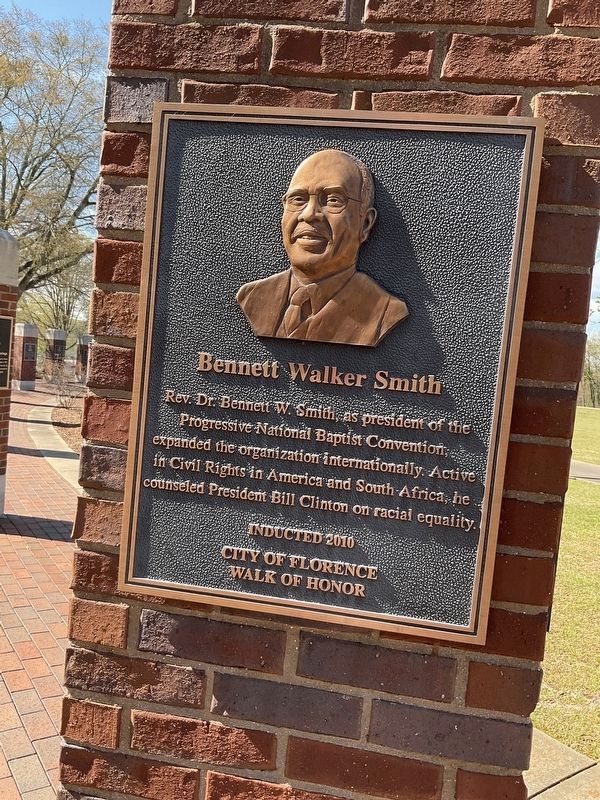
Bennett Walker Smith Marker
101 ► Alabama, Lauderdale County, Florence — Bennett Walker Smith — City of Florence Walk of Honor —  |
| Near Hightower Place south of Veterans Drive (Alabama Route 133), on the left when traveling south. | |||
| 102 ► Alabama, Lauderdale County, Florence — Continuity — |
| Near South Court Street at Canal Street, on the right when traveling south. | |||
| 103 ► Alabama, Lauderdale County, Florence — Edward A. O'Neal Home — Home of the Father-Son Governors — |
| On North Court Street 0.1 miles north of Hermitage Drive, on the right when traveling north. | |||
| 104 ► Alabama, Lauderdale County, Florence — Edward Asbury O'Neal, III — City of Florence Walk of Honor — |
| Near Hightower Place south of Veterans Drive (Alabama Route 133), on the left when traveling south. | |||
| 105 ► Alabama, Lauderdale County, Florence — General Arthur E. Brown, Jr. — City of Florence Walk of Honor — |
| Near Hightower Place just south of Veterans Drive (Alabama Route 133), on the left when traveling south. | |||
| 106 ► Alabama, Lauderdale County, Florence — Governor Hugh McVay Home Site and Cemetery — |
| On N. Cox Creek Parkway. | |||
| 107 ► Alabama, Lauderdale County, Florence — James Thomas Rapier — City of Florence Walk of Honor — |
| Near Hightower Place south of Veterans Drive (Alabama Route 133), on the left when traveling south. | |||
| 108 ► Alabama, Lauderdale County, Florence — John McKinley Associate Justice, U.S. Supreme Court — |
| Near South Court Street. | |||
| 109 ► Alabama, Lauderdale County, Florence — Justice John A. McKinley — City of Florence Walk of Honor — |
| Near Hightower Place south of Veterans Drive (Alabama Route 133), on the left when traveling south. | |||
| 110 ► Alabama, Lauderdale County, Florence — Justice John McKinley Federal Building — |
| On N. Seminary St. close to E. Tombigbee St.. | |||
| 111 ► Alabama, Lauderdale County, Florence — Maj. Gen. George W. Goethals — City of Florence Walk of Honor — |
| Near Hightower Place south of Veterans Drive (Alabama Route 133), on the left when traveling south. | |||
| 112 ► Alabama, Lauderdale County, Florence — Michael Hall Mobbs — City of Florence Walk of Honor — |
| Near Hightower Place south of Veterans Drive (Alabama Route 133), on the left. | |||
| 113 ► Alabama, Lauderdale County, Florence — Oscar Stanton DePriest — City of Florence Walk of Honor — |
| On Hightower Place. | |||
| 114 ► Alabama, Lauderdale County, Florence — Ronnie Gene Flippo — City of Florence Walk of Honor — |
| Near Hightower Place south of Veterans Drive (Alabama Route 133), on the left when traveling south. | |||
| 115 ► Alabama, Lauderdale County, Florence — Woodrow Wilson Park — 1818 — |
| On East Tuscaloosa Street at North Wood Street (County Road 47), on the right when traveling east on East Tuscaloosa Street. | |||
| 116 ► Alabama, Lauderdale County, Florence, East Florence — Tennessee Valley Authority — |
| On Hightower Place. | |||
| 117 ► Alabama, Lawrence County, Courtland — The African-American Experience — |
| On College Street south of Tennessee Street, on the right when traveling south. | |||
| 118 ► Alabama, Lawrence County, Hillsboro — Home of Gen. Joseph Wheeler — 1836~1906 — |
| On Alternate U.S. 72 at County Road 377, on the right when traveling east on U.S. 72Alternate . | |||
| 119 ► Alabama, Lawrence County, Moulton — Anne Newport Royall — |
| On Market Street (Alabama Route 33) at Court Street (County Route 460), on the right when traveling south on Market Street. | |||
| 120 ► Alabama, Lawrence County, Moulton — Cheatham Road — |
| On County Route 33. | |||
| 121 ► Alabama, Lawrence County, Moulton — General Leroy Pope Walker — |
| On Market Street (Alabama Route 33) at College Street, on the right when traveling south on Market Street. | |||
| 122 ► Alabama, Lawrence County, Moulton — Judge Thomas M. Peters — |
| On Market Street (Alabama Route 33) at College Street, on the right when traveling south on Market Street. | |||
| 123 ► Alabama, Lawrence County, Mount Hope — Major David Hubbard — |
| On County Road 23 at County Road 26, on the right when traveling north on County Road 23. | |||
| 124 ► Alabama, Lee County, Auburn — The Auburn Guards — |
| On Mitcham Avenue east of North Gay Street, on the right when traveling east. | |||
| 125 ► Alabama, Lee County, Opelika — Bobby James Freeman — August 1, 1937 — November 2, 2021 — |
| On South Railroad Avenue just south of South 10th Street. | |||
| 126 ► Alabama, Lee County, Opelika — Lee County Courthouse / Lee County Probate Judges |
| On South 9th Street south of Avenue A, on the right when traveling south. Reported permanently removed. | |||
| 127 ► Alabama, Lee County, Opelika — Lee County Courthouse / Lee County Probate Judges — |
| On South 9th Street south of Avenue A, on the right when traveling south. | |||
| 128 ► Alabama, Limestone County, Athens — Coleman Family — Coleman Hill — |
| On 4th Street at Grace Avenue, on the right when traveling west on 4th Street. | |||
| 129 ► Alabama, Limestone County, Athens — Courthouse and Poor Farm Fence — |
| On South Jefferson Street near West Washington Street, on the right when traveling north. | |||
| 130 ► Alabama, Limestone County, Athens — Governor George S. Houston Home — |
| On Market Street West near Houston Street, on the right when traveling west. | |||
| 131 ► Alabama, Limestone County, Athens — Judge David Lee Rosenau, Jr. — 1903-1998 — |
| On North Jefferson Street at Market Street West, on the right when traveling north on North Jefferson Street. | |||
| 132 ► Alabama, Limestone County, Athens — Limestone County Courthouse Bell — |
| On North Jefferson Street at Market Street West, on the right when traveling north on North Jefferson Street. | |||
| 133 ► Alabama, Limestone County, Capshaw — Nicholas Davis — |
| On Nick Davis Road (County Road 44) 0.5 miles west of Sanderson Road (County Road 127), on the left when traveling west. | |||
| 134 ► Alabama, Limestone County, Elkmont — Sims Settlement — |
| On Easter Ferry Road south of Morris Road (County Road 49), on the right when traveling south. | |||
| 135 ► Alabama, Limestone County, Mooresville — Mooresville — Incorporated in 1818 — |
| On Lauderdale Street east of High Street, on the right when traveling west. | |||
| 136 ► Alabama, Lowndes County, Hayneville — Town of Hayneville |
| On West Tuskeena Street (Alabama Route 21) at South Commerce Street ( Route 97), on the left when traveling west on West Tuskeena Street. Reported permanently removed. | |||
| 137 ► Alabama, Macon County, Tuskegee — 9 — "Trade With Your Friends" — The Tuskegee Boycott — The Tuskegee Civil Rights and Historic Trail — |
| On Westside Street south of West Northside Street, on the left when traveling south. | |||
| 138 ► Alabama, Macon County, Tuskegee — Macon County Legal Milestone — |
| On East Rosa Parks Avenue at Eastside Street, on the left when traveling east on East Rosa Parks Avenue. | |||
| 139 ► Alabama, Macon County, Tuskegee Institute — 2 — Charles Goode Gomillion — The Tuskegee Civil Rights and Historic Trail — |
| On Bibb Street 0.2 miles north of Hudson Street, on the left when traveling north. | |||
| 140 ► Alabama, Macon County, Tuskegee Institute — Fred David Gray — Civil Rights Attorney and Legislator / Advocate for Victims and History — |
| On West Montgomery Road at Kelly Drive on West Montgomery Road. | |||
| 141 ► Alabama, Macon County, Tuskegee Institute — 5 — Tuskegee Civic Association — The Tuskegee Civil Rights and Historic Trail — |
| On West Montgomery Road at Chambliss Street, on the left when traveling west on West Montgomery Road. | |||
| 142 ► Alabama, Madison County, Brownsboro — Trail of Tears — Drane/Hood Overland Route — |
| On Lee Highway/John T. Reid Parkway (U.S. 72 at milepost 109) at Brock Road, on the right when traveling west on Lee Highway/John T. Reid Parkway. | |||
| 143 ► Alabama, Madison County, Gurley — "Wildwood" — |
| On John T Reid Parkway/Lee Highway (U.S. 72) 0.1 miles east of Walker Street, on the right when traveling west. | |||
| 144 ► Alabama, Madison County, Hazel Green — John Williams Walker (1783-1823) — |
| On U.S. 231/431 1 mile south of Grimwood Road (County Road 100), on the right when traveling south. | |||
| 145 ► Alabama, Madison County, Huntsville — Alabama’s Constitution and Statehood — |
| On Gates Avenue at Franklin Street S.E. on Gates Avenue. | |||
| 146 ► Alabama, Madison County, Huntsville — Calhoun House — |
| On Greene Street Southeast at Eustis Avenue Southeast, on the left when traveling south on Greene Street Southeast. | |||
| 147 ► Alabama, Madison County, Huntsville — Huntsville — |
| On Church Street Southwest north of Williams Avenue Southwest, on the right when traveling north. | |||
| 148 ► Alabama, Madison County, Huntsville — Madison County — |
| On Northside Square at Eastside Square, on the left when traveling west on Northside Square. | |||
| 149 ► Alabama, Madison County, Huntsville — Madison Street — Did you know? — |
| On Southside Square at Madison Street SE, on the left when traveling east on Southside Square. | |||
| 150 ► Alabama, Madison County, Huntsville — Site - Alabama’s First Constitutional Convention — |
| On Franklin Street Southeast, on the right when traveling south. | |||
| 151 ► Alabama, Madison County, Huntsville — Site The Huntsville Inn — A three-story brick building erected before 1817 — |
| On Eastside Square, on the right. | |||
| 152 ► Alabama, Madison County, Huntsville — Tallulah Bankhead / I. Schiffman Building — |
| On Eastside Square at Eustis Avenue Southeast, on the right on Eastside Square. | |||
| 153 ► Alabama, Madison County, Madison — "The Roundhouse" — |
| On Front Street, on the right when traveling east. | |||
| 154 ► Alabama, Madison County, Madison — Trail of Tears — Drane Overland Route — |
| On Front Street close to Church Street. | |||
| 155 ► Alabama, Madison County, Madison — White Hall — 1878 — |
| Near Whitehall Road west of Hughes Road, in the median. | |||
| 156 ► Alabama, Marengo County, Demopolis — Bluff Hall — |
| On North Commissioners Avenue north of West Lyon Street, on the left when traveling north. | |||
| 157 ► Alabama, Marion County, Hamilton — History of Marion Territory and Marion County Courts — |
| On Military Street South (U.S. 278) at 1st Avenue SW, on the right when traveling south on Military Street South. | |||
| 158 ► Alabama, Mobile County, Mobile — 1 — Andrew N. Johnson — |
| On Dauphin Street at North Lawrence Street, on the left when traveling east on Dauphin Street. | |||
| 159 ► Alabama, Mobile County, Mobile — Cadillac Homesite — |
| On Conti Street 0.1 miles west of South Royal Street, on the right when traveling west. | |||
| 160 ► Alabama, Mobile County, Mobile — 7 — Christopher First Johnson House — |
| On Martin Luther King Jr. Avenue at Peach Street, on the right when traveling west on Martin Luther King Jr. Avenue. | |||
| 161 ► Alabama, Mobile County, Mobile — John L. LeFlore — 1903- 1976 — |
| Near St. Anthony Street at North Broad Street. | |||
| 162 ► Alabama, Mobile County, Mobile — 24 — John L. LeFlore — Non-Partisan Voters League — |
| On St Francis Street at North Warren Street, on the right when traveling west on St Francis Street. | |||
| 163 ► Alabama, Mobile County, Mobile — Joseph (Joe) N. Langan — 1912 - 2004 — |
| Near Spring Hill Avenue at North Broad Street. | |||
| 164 ► Alabama, Mobile County, Mobile — Oakleigh — |
| On Oakleigh Place at Savannah Street, on the left when traveling north on Oakleigh Place. | |||
| 165 ► Alabama, Mobile County, Mobile — On this Spot Woodrow Wilson Said: — October 27, 1913 — 1913 - 1924 — |
| On Conti Street at South Joachim Street, on the left when traveling west on Conti Street. | |||
| 166 ► Alabama, Mobile County, Mobile — To Jean Baptiste LeMoyne — Sieur de Bienville — |
| Near Dauphin Street at North Conception Street. | |||
| 167 ► Alabama, Mobile County, Mobile — 39 — Vernon Z. Crawford Law Firm — |
| On Martin Luther King Jr. Avenue at Patton Avenue, on the right when traveling east on Martin Luther King Jr. Avenue. | |||
| 168 ► Alabama, Mobile County, Mobile, Central Business District — Alfonse X (The Wise) — 1221-1284 — |
| On Government Street at S Hamilton Street, on the right when traveling east on Government Street. | |||
| 169 ► Alabama, Mobile County, Mobile, Central Business District — Bernardo de Galvez — 1746-1786 — |
| On Government Street at S Hamilton Street, on the right when traveling east on Government Street. | |||
| 170 ► Alabama, Mobile County, Mt. Vernon — 5 — Ephraim Kirby's Grave — Mount Vernon History Trail — |
| On Old Military Road East (Alabama Route 96) 0.1 miles north of Old Military Road South, on the right when traveling north. | |||
| 171 ► Alabama, Monroe County, Monroeville — A County Older Than The State — Monroe County — |
| On North Alabama Avenue (State Road 21), on the left when traveling north. | |||
| 172 ► Alabama, Monroe County, Perdue Hill — Claiborne — |
| On U.S. 84 at Old Fort Claiborne Road, on the right when traveling west on U.S. 84. | |||
| 173 ► Alabama, Montgomery County, Maxwell Air Force Base — Lister Hill Center — Named in honor of Senator Lister Hill — 1894-1984 — |
| On Lemay Plaza 0.1 miles south of Maxwell Boulevard, on the right when traveling south. | |||
| 174 ► Alabama, Montgomery County, Montgomery — Alabama Highway Patrol — |
| On Washington Avenue 0.1 miles east of North Union Street, on the right when traveling west. | |||
| 175 ► Alabama, Montgomery County, Montgomery — Albert L. Patterson — |
| Near Monroe Street east of North Bainbridge Street, on the right when traveling east. | |||
| 176 ► Alabama, Montgomery County, Montgomery — Associate Justices — |
| On Dexter Avenue 0.3 miles west of South Decauter Street, on the right when traveling west. | |||
| 177 ► Alabama, Montgomery County, Montgomery — Black Members of the Alabama Legislature Who Served During The Reconstruction Period of 1868-1879 — |
| On Tullibody Drive at University Drive North, on the right when traveling south on Tullibody Drive. | |||
| 178 ► Alabama, Montgomery County, Montgomery — Camellia Designated Alabama State Flower — |
| On Monroe Street east of North Bainbridge Street, on the right when traveling east. | |||
| 179 ► Alabama, Montgomery County, Montgomery — Clement Clay "Bo" Torbert, Jr. — Twenty-Fifth Chief Justice — 1977-1989 — |
| Near Dexter Avenue at North Decatur Street, on the right when traveling east. | |||
| 180 ► Alabama, Montgomery County, Montgomery — Ernest C. “Sonny” Hornsby — Twenty-Sixth Chief Justice — 1989-1995 — |
| Near Dexter Avenue at North Decatur Street, on the right when traveling west. | |||
| 181 ► Alabama, Montgomery County, Montgomery — Governor Jones House — |
| On Adams Avenue at South Hull Street, on the left when traveling east on Adams Avenue. | |||
| 182 ► Alabama, Montgomery County, Montgomery — Governor William Calvin Oates / Colonel W. C. Oates, CSA at Gettysburg — |
| Near Stella Street at Clarmont Avenue, on the right when traveling north. | |||
| 183 ► Alabama, Montgomery County, Montgomery — Great Depression / New Deal — |
| Near Dexter Avenue east of Decatur Street, on the right when traveling east. | |||
| 184 ► Alabama, Montgomery County, Montgomery — Jefferson Davis — June 3, 1808 - December 6, 1889 — Soldier Scholar Statesman — |
| On North Bainbridge Street at Dexter Avenue, on the right when traveling north on North Bainbridge Street. | |||
| 185 ► Alabama, Montgomery County, Montgomery — Jonathan Coggswell Farley / Montgomery's First Election — |
| On Dexter Avenue at South Hull Street, on the left when traveling east on Dexter Avenue. | |||
| 186 ► Alabama, Montgomery County, Montgomery — Joseph Lister Hill — 1894 - 1984 — |
| On Washington Avenue, on the right when traveling west. | |||
| 187 ► Alabama, Montgomery County, Montgomery — 9 — Judge Frank M. Johnson: Judicial Fairness in the Age of Segregation — Molton and Montgomery Streets — Selma to Montgomery National Historic Trail — |
| On Montgomery Street at Catoma Street, on the right when traveling south on Montgomery Street. | |||
| 188 ► Alabama, Montgomery County, Montgomery — Lucien Dunbibben Gardner — Twenty-Second Chief Justice — 1940-1951 — |
| Near Dexter Avenue at North Decatur Street, on the right when traveling west. | |||
| 189 ► Alabama, Montgomery County, Montgomery — Montgomery City Hall / Funeral for Hank Williams — |
| On North Perry Street at Monroe Street, on the left when traveling south on North Perry Street. | |||
| 190 ► Alabama, Montgomery County, Montgomery — Populism / 1901 Constitution — |
| On Dexter Avenue east of South Decatur Street, on the right when traveling east. | |||
| 191 ► Alabama, Montgomery County, Montgomery — Smith - Joseph - Stratton House — |
| On Alabama Street east of South McDonough Street, on the right when traveling east. | |||
| 192 ► Alabama, Montgomery County, Montgomery — The Alabama Appellate Courts — |
| On Dexter Avenue at North Hull Street, in the median on Dexter Avenue. | |||
| 193 ► Alabama, Montgomery County, Montgomery — The Alabama Judicial System and the Chief Justices of the Supreme Court. — |
| On Dexter Avenue 0.3 miles west of South Decauter Street, on the right when traveling west. | |||
| 194 ► Alabama, Montgomery County, Montgomery — The First Offices of the Confederate Government — |
| On Bibb Street at Commerce Street, on the right when traveling west on Bibb Street. | |||
| 195 ► Alabama, Montgomery County, Montgomery — The Frank M. Johnson, Jr. Federal Building and US Courthouse — |
| On Church Street at Lee Street, on the right when traveling north on Church Street. | |||
| 196 ► Alabama, Montgomery County, Montgomery — 11 — Thousands Protest at the Seat of Government — Dexter Avenue — Selma to Montgomery National Historic Trail — |
| On Dexter Avenue at South Bainbridge Street, on the right when traveling east on Dexter Avenue. | |||
| 197 ► Alabama, Montgomery County, Montgomery — William Lowndes Yancey — |
| On East Jefferson Street 0.1 miles east of North Hull Street, on the left when traveling east. | |||
| 198 ► Alabama, Montgomery County, Montgomery, Centennial Hill — A County Older Than the State — Montgomery County — 1816 — |
| On South Lawrence Street at Washington Avenue, on the right when traveling south on South Lawrence Street. | |||
| 199 ► Alabama, Montgomery County, Montgomery, Centennial Hill — Site of the Warren Reese House — |
| On South Decatur Street (Alabama Route 21) at Scott Street on South Decatur Street. | |||
| 200 ► Alabama, Montgomery County, Montgomery, Garden District — Alabama Governor's Mansion — Built 1907 — |
| On South Perry Street, on the left when traveling north. | |||
10605 entries matched your criteria. Entries 101 through 200 are listed above. ⊲ Previous 100 — Next 100 ⊳