Mary Alfred was one of Baker City’s pioneer businesswomen. She and here husband, Francis Alfred, came to Baker County in 1870. She had a millinery and mantua (robe) shop in her home. Mr. Alfred drove a stage between Baker City and La Grande. . . . — — Map (db m108053) HM
In the early days of the 20th Century, the Antlers Hotel was a bustling three-story hotel which boasted a fine restaurant and bar. The hotel had an elevator. The upper corridors were naturally lighted by “light wells” and skylights.
In 1910, a . . . — — Map (db m108096) HM
Prominent local businessman William Pollman contracted to have the Baker Loan and Trust Building built in 1910, after a major fire destroyed another building on the site, along with two buildings to the south.
The building was designed by . . . — — Map (db m108043) HM
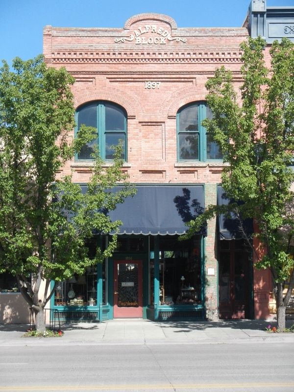
Basche-Sage Hardware Co. was one of Baker City’s largest firms for more than 100 years. The company began when Peter Basche purchased a Baker City tin shop in 1876. In 1888, Basche merged with the Sage and Grace hardware store. Stores were opened in . . . — — Map (db m108084) HM
The Bishop Building stands as a testament to the strength and durability of volcanic tuff, which was used to construct many of Baker City’s major buildings during the first decade of the 1900s. A fire gutted the building in 1940, but it remained . . . — — Map (db m108079) HM
When constructed, this building was the third bank building to occupy this site. J.W. Virtue, a pioneer gold mining entrepreneur, built the first bank in 1873. It was the first stone building on Main Street. The building was ruined by a fire in . . . — — Map (db m108037) HM
The central two-story portion of their building was constructed in 1910. In the 1940s, single-story wings of reinforced concrete were added to both sides of the original structure.
In its early years, the building housed the Chas. I. Flynn and . . . — — Map (db m108102) HM
When Baker City reigned as the “Queen City of the Inland Empire,” the Geiser Grand Hotel was a jewel in her crown. Built in 1889, the hotel soon earned a reputation for offering the finest accommodations between Seattle and Salt Lake . . . — — Map (db m108065) HM
This building was one of Baker City’s first masonry structures when constructed about 1879. Solomon’s One Price Clothing House originally occupied the first floor of the north half of the building. By the 1990s, footware had been sold in the . . . — — Map (db m108211) HM
In October 1940 Gwilliam Brothers Bakery celebrated the business’s new building with a grand opening. Designed for high-volume bakery operations, the brick structure had a delivery truck garage in the rear and a large central oven set on a concrete . . . — — Map (db m108161) HM
Haskell was one of Baker City’s leading real estate developers of the late 1800s and early 1900s. He also engaged in many other pursuits.
He was born in 1850 in Ohio. At age 18, he went to Montana to become a miner. He later mined in Nevada, . . . — — Map (db m108064) HM
The lot which this building occupies was first the location of a wood frame structure housing the McCord Brothers blacksmith shop. In 1867, Dr. J.M. Boyd and John W. Wisdom leased the structure to open Baker City’s first drug store. Wisdom continued . . . — — Map (db m108041) HM
John Jett’s stonemason’s skills are manifest in the inscription carved at the roof level of his building - “J.H. Jett Marble Works, 1901.”
The Jett Building was the first in Baker City of volcanic tuff construction. Ten commercial or . . . — — Map (db m108206) HM
This site was the location of Baker City’s first brick hotel, the Cosmopolitan. The Rev. P. DeRoo, a Catholic priest who aquired (sic) extensive real estate interests, had the two-story building built in 1875. The hotel also served as the city’s . . . — — Map (db m108063) HM
Mike Hoff, a “tonsorial artist” (barber) in Baker City in the 1890s, built this building for his business. After a few years, however, Hoff went into partnership with Valentine Bildner to open a saloon in the building.
During the . . . — — Map (db m108060) HM
The Lynndale Building was constructed about 1890. The northernmost of the three first-floor bays was occupied by a saloon from the building's earliest days. The establishment first was named Henry the Fourth, then The Club. Later it became the . . . — — Map (db m108077) HM
The Mann Block, built in 1890, originally housed one of the many saloons located in this block during Baker City’s early, rowdy years. Like most of the establishments, the saloon operated on the first floor, with a bawdy house and gambling rooms . . . — — Map (db m108052) HM
“McCord’s Corner” contributed much to Baker City history.
S. (Syrenus) B. McCord was the first mayor of Baker City. City residents elected him to four terms, and he also served several terms as county treasurer.
In 1873, McCord . . . — — Map (db m108209) HM
This building was the location in the 1920s of the Lew Brothers Tire Co., which later moved to Bridge Street. After the tire company relocated, the building was purchased by Glenn Miller, owner of Miller’s Lunch in the adjacent building to the east. . . . — — Map (db m108097) HM
This stucco-over-clay block building was constructed in 1923 as a "temporary" structure after a fire destroyed another building on the site. A block store first occupied the building, then an ice cream parlor.
Glenn Miller, a local candy-maker, . . . — — Map (db m108162) HM
The Mint-Fox Building was constructed as two adjoining structures, the south half in 1888, the north in 1889. The buildings were erected by A.A. Houston, a local builder. Houston first rented the south building to two miners, Lorenzo Durkee and . . . — — Map (db m108061) HM
Baker City at the beginning of the 20th Century was the hub for a vast area of commerce, including mining, agriculture and forest products. Merchandise flowed into the city for distribution to dozens of smaller communities. Likewise, business . . . — — Map (db m108194) HM
William Shoemaker, a partner in a Baker City wholesale grocery and grain business, built this building in 1906. Before moving to Baker City, Shoemaker had been in business at Rock Creek, a small community in north Baker Valley. He built and operated . . . — — Map (db m108103) HM
Beginning in 1843, thousands of Oregon Trail emigrants trekked through this region toward new lives in the West. This epic journey indelibly etched the landscape with wagon ruts, such as those near by. When Henry Griffin, a prospector from . . . — — Map (db m108128) HM
This building, constructed in the 1890s, was the location of the Smoke Shop for approximately 50 years. The Smoke Shop was a typical men’s gathering place of the period, offering tobacco, beverages, billiards and card games.
The first business . . . — — Map (db m108035) HM
A fire that started in a billiard hall destroyed all the structures on this block in 1886. Several property owners chose to rebuild, and four adjoining brick buildings were constructed the following year. This building was constructed for Messrs. . . . — — Map (db m108050) HM
In the early 1880s, the Red Boy Vein was located and claimed by Daniel Pinson, a Cherokee Indian. The claim did not pan enough free gold to work without a mill. His only legacy is the mine's name.
In 1886 it became a paying proposition when . . . — — Map (db m106767) HM
Natural landforms gave local settlers an opportunity to shape history. As you explore the remains of the gold rush era, consider the partnership of people and nature.
A lake the ice forgot
When the Ice Age glaciers melted, they left . . . — — Map (db m106762) HM
Welcome to the historic world of Sumpter Valley Dredge State Heritage Area! Here you will find one of the largest gold dredges in the United States.
There are many ways to learn about the dredge and the people who worked it, from tours to . . . — — Map (db m106794) HM
As you drove here, you probably saw long rows of rocks all over the valley. These are tailings - topsoil , riverbed rock, and bedrock, left behind by 40 years of dredging.
Because of the dredges' systematic destruction, the original meadow and . . . — — Map (db m111243) HM
The dredge is a huge but simple machine for mining an ancient river bed for gold. It is an expensive, powerful improvement on the shovel and rocker box.
Miners used to call the dredge a "goose"---and for good reason. The dredge is "fed" at the . . . — — Map (db m106890) HM
The dredge floated in about nine feet of water- but it could move anywhere it wanted in the valley because it took its pond with it.
Hard to imagine, isn't it? It worked because the dredge dug a pond for itself to float in as it moved -- . . . — — Map (db m106871) HM
Bank was established in 1899 with a capital stock of $10,000.00. The first officers were A.P. Goss, President and A.H. Goss, Cashier. The bank was destroyed by fire on August 13, 1917 and the vault is all that remains. — — Map (db m111241) HM
The bustling boom town of Sumpter stretched from here westward to Powder River at the peak of the mining boom.
The mining camp was named for Fort Sumter, South Carolina, by five ex-Confederate soldiers who discovered gold near here in 1862. . . . — — Map (db m112914) HM
The Benton County State Bank building was dedicated on July 25, 1907. The bank, built on the ruins of a burned saloon, was representative of a period of growth and prosperity in Corvallis at the beginning of the 20th century.
Corvallis' . . . — — Map (db m117442) HM
The banks of the Willamette River were the focus of early town development. The town plat for Marysville was files on February on February 25, 1851, by Joseph C. Avery, using a portion of his land claim of 1845. The town included property from the . . . — — Map (db m117488) HM
The First Congregational Church was built here in 1917 to serve a congregation that had outgrown its original 1889 building at Third and Jefferson streets. Designed by architect Roy Dobell, a former instructor at Oregon Agricultural College (OAC, . . . — — Map (db m117268) HM
This is one of the first mill stones or burns to be used in this section of Oregon. This was originally quarried in France and shipped around the horn from New York in 1850 by sailing vessel. In 1852, was transported by oxen team from Portland to . . . — — Map (db m116840) HM
The first steamboat to reach Corvallis was the sidewheeler Canemah in October of 1851. With this arrival, Corvallis joined Oregon's steamboat era, with tis stories of risk, profit, rivalries, mergers, heroics, innovation and disasters. . . . — — Map (db m117465) HM
Site of the earliest boat landing Lower Town, Marysville, 1851 Presented to City of Corvallis, Oregon Centennial Celebration, June 1957 by the Winema Chapter Daughters of the American Revolution — — Map (db m107333) HM
This variable pitch water wheel was installed in the Long Tom River in 1906 to power the grain & flour machinery at the Adam Wilhelm Flour Mill. It also powered an electric generator that was later installed to provide electricity to the mill & the . . . — — Map (db m119283) HM
George M. Rogers purchased this lot in 1918 and lived in its existing small house until 1929, when he engaged Van Evera Bailey, a noted Portland architect, to design this unique Arts and Crafts/Mediterranean style residence. Exterior is . . . — — Map (db m119859) HM
Henry Dodge Green and his brother John Green came to Oregon from New York in 1852. In partnership with H. C. Leonard, the Green brothers procured the gas and water franchises for the City of Portland. The cost of shipping cast-iron gas and water . . . — — Map (db m116109) HM
This cottage is the last survivor of cottages built for workers in Oswego's iron industry. It was probably built in the late 1870s or early 1880s by Albert Clinefelter or Lucien Davidson, local carpenters who constructed many buildings for the . . . — — Map (db m120039) HM
This Arts and Crafts style building was constructed in 1940 as the Murphy Real Estate office. It is one of a cluster of buildings on State Street designed by the prominent local architect, Richard Sundeleaf. The half-timbered architecture was . . . — — Map (db m116518) HM
In the early 19th century, the river landing at the mouth of Oswego Creek was a convenient camping place for explorers, fur traders, and pioneers. In the words of one old timer, it was "a stopping place, a sort of a relay station for boats both . . . — — Map (db m121328) HM
This mass of solidified iron from the hearth of the Oswego furnace is known as a 'Salamander'. It is named after a mythological amphibian that lived in fire. Salamanders often formed in the bottom of 19th Century iron furnaces and were removed, with . . . — — Map (db m116143) HM
On this site Oswego's first industry, a saw mill, was established in 1850 by Albert Alonzo Durham on this portion of his 637 acre Donation Land Grant which included "Old Town" and much of East Oswego. He advertised his new mill in the . . . — — Map (db m117224) HM
Commerce came quickly to the area as pioneers cleared land and became established. Pasture and grazing was common but presented transportation problems before refrigeration and good roads or bridges. The Clear Creek Creamery co-op was formed to . . . — — Map (db m114236) HM
Dr. Forbes Barclay left Scotland in 1839 for Fort Vancouver (Washington) where he became chief physician for Hudson's Bay Company. He moved to Oregon City in 1850 where he practiced medicine for many years. He was one of Oregon City's early mayors, . . . — — Map (db m8692) HM
Born in Riviere du Loup, Canada, October 19, 1784.
1824 Came to the Oregon Country as Chief Factor of the Columbia Department of the Hudson's Bay Company.
1829 Located his claim to the present site of Oregon City.
1845 Resigned his . . . — — Map (db m8699) HM
Chief Factor, 1821-1845, and Superintendent of the Columbia Department, 1824-1821, of the Hudson's Bay Company, laid claim to and took possession of the Site of Oregon City in 1829.
In 1842 he had the site surveyed, and subsequently dedicated . . . — — Map (db m114027) HM
"He stood among his pioneer contemporaries like towering old (Mount) Hood ... a born leader of men." -- Willard H Res, description of John McLoughlin during speech, 1879
His personality was measured in patience, generosity, . . . — — Map (db m114065) HM
George Abernethy who arrived at Willamette Falls in 1840 by ship, took a land claim that stretched from the Willamette River to Holcomb Hill. The neck of land that followed Abernethy Creek acrosss Green Point became known as Abernethy Green. Oregon . . . — — Map (db m114032) HM
Born in Washington Co. Va., Meek leaves home at age 18, arriving in St. Louis in the fall of 1828. Meek signs on as a trapper with the Rocky Mtn. Fur Co., remaining in the Rockies until 1839.
1839 - 1843: Meek travels to the Willamette Valley and . . . — — Map (db m8673) HM
On this site was an early firehall. Current structure was built as City Hall housing city offices, Police Dept., and the jail, all of which remained until the mid 40s. Oregon City Beauty School occupied main floor and basement for 22 years. Jail . . . — — Map (db m8747) HM
In the city he founded, in this house he built, lived Dr. John McLoughlin, 1846-57.
He won enduring fame for his generous and humane aid to early American settlers in the Oregon Country, as Chief Factor and Superintendent of the Hudson’s Bay . . . — — Map (db m8693) HM
Built by Ed Johnson as a full service barber shop with 4 chairs and bathing facilities. Basement still has massive brick boiler for hot water originally fired by sawdust from local mill. Converted to restaurant in 1986. — — Map (db m8746) HM
Oregon City - once known as Willamette Falls - was early the site of an Indian salmon fishing village. The falls furnished the power for a lumber mill which began operation in 1842. A flour mill in 1844. A woolen mill in 1864 and the first paper . . . — — Map (db m113515) HM
400 feet south
of this marker
stood the home of
Peter Skene Ogden
Chief Factor of
Hudson's Bay Co.
and rescuer of the
survivors of the
Whitman Massacre. — — Map (db m8714) HM
'It was two stories, 68 x 105, and was the first hotel west of the Rocky mountains." -- Harvey K. Hines, An Illustrated History... (1893)
In 1842 Dr. Elijah White recruited over one hundred people to emigrate across the Oregon Trail. . . . — — Map (db m114165) HM
Chief factor of the Hudson’s Bay Company at Fort Vancouver, philanthropist, and founder of Oregon City. The land on the east bank of the Willamette River at the falls was claimed by Dr. McLoughlin and the Hudson’s Bay Co. in 1828-29. First called . . . — — Map (db m8669) HM
Was early the site of an Indian salmon fishing village. The falls furnished the power for a lumber mill which began operation in 1842, a flour mill in 1844, a woolen mill in 1864 and the first paper mill in the Pacific Northwest in 1867. The first . . . — — Map (db m113514) HM
Still in use below this point-were opened on New Years Day, 1873, when the steamer Maria Wilkins became the first vessel to navigate up the west end of Willamette Falls. Farming and shipping interests had long sought to eliminate expensive portages . . . — — Map (db m8667) HM
Built at the turn of the 20th Century, the Norris Young Machine Shop served the farming community. Young, an accomplished machinist and inventor, repaired farm machinery and logging equipment.
Young was an enterprising businessman who along . . . — — Map (db m127204) HM
Built in 1905 and named for its colorful owner, Bill Flynn’s Saloon was a favorite hangout for residents and weary travelers. Farmers would park their wagons outside the saloon to rest their horses before the climb up “Whiskey Hill,” . . . — — Map (db m127205) HM
In 1921, responding to increasing popularity of travel by automobile, Captain Fritz Elfving formed the Astoria-North Beach Ferry Company to transport passengers and cars across the Columbia River.
His ferry slip on the Oregon side of the river . . . — — Map (db m113269) HM
The Columbia River is a highway for huge amounts of freight. The most frequent outbound cargoes include wheat and other agricultural products from the inland Northwest, logs and lumber, and mining products like coke or potash. Entering the river, . . . — — Map (db m113238) HM
Before the fire of 1922, much of downtown Astoria was built on pilings over the river. People built out from the original hilly shoreline, creating a level commercial district with access to the water.
Every type of business might be . . . — — Map (db m113237) HM
People have always turned to the river for enjoyment and just plain fun. Today you may see recreational sailboats, motorboats, jet-skis, kayaks, cruise ships, windsurfers, or kiteboards sharing the river with huge commercial ships.
In the . . . — — Map (db m113250) HM
The Columbia River Bar is considered by professional mariners to be the most dangerous bar crossing on the planet.
The Pilot Boat Peacock was built in 1964 based on a German North Sea rescue boat design.
Put into service on the . . . — — Map (db m112994) HM
Towboats began working on the Columbia in the mid 19th century.
Powerful steam tugs towed sailing vessels over the Columbia River bar.
Sternwheel steamboats, many of which operated as tugs, plied the entire Columbia River system.
During . . . — — Map (db m113234) HM
This area was once the crossroads of several cultures in Astoria.
Along the waterfront to the east and west were over 20 canneries with their hordes of workers, many of them Chinese.
After 12 to 16 hours of hard work, the Chinese went home to . . . — — Map (db m112997) HM
This building was constructed in 1896 by the North Pacific Brewery and rebuilt 1928-29 by the city of Astoria to serve as a fire station.
City Commission
J C Brook, Mayor
John R Arnold -'28
Anton Sorensen -'29
E C Gearhart
Victor . . . — — Map (db m113823) HM
In 1849, the U.S. Government established the first U.S. Customs Office on the Pacific Coast in Astoria. Located just 200 feet west of this site, the founding of the original Custom House brought change to the Northwest. It signaled a growing U.S. . . . — — Map (db m113819) HM
Desiring to dominate the areas explored by Lewis and Clark, John Jacob Astor sent expeditions overland and by sea to seize the mouth of the Columbia. The schooner Tonquin arrived first and work was begun on this site April 12, 1811. "The foliage was . . . — — Map (db m113558) HM
For thousands of years, Native Americans thrived on salmon fishing on the Columbia River. They traded dried fish with other native people all over the west. In the 1870s, later settlers also made commercial fishing a way of life. It remains a . . . — — Map (db m113239) HM
The exterior of this reconstructed U.S. Custom House tells only part of the story. Use your imagination to visualize the space inside: a room sparsely furnished with a desk, perhaps a bookcase, wooden file cabinets, and a chair or two. The small . . . — — Map (db m113820) HM
The Pilot Boat Peacock was built to meet the challenging conditions at the mouth of the Columbia River. Pilots transferred to and from ships by means of the retrievable daughter boat off the stern. The vessel is based on a North Sea rescue . . . — — Map (db m112995) HM
The mouth of the Columbia River is known to mariners as one of the most hazardous crossings in the world.
Large ocean-going vessels rely upon highly skilled pilots to bring them across the bar and then to guide them safely to ports up and down . . . — — Map (db m113233) HM
Here you look out over Astoria's first neighborhood.
Platted in 1846 by prominent pioneers, Colonel John McClure and John Shively, this district was home to our most influential citizens; elected officials, leading businessmen, cannery . . . — — Map (db m113014) HM
On Christmas Eve, 1885, direct current flowed from a small dynamo in a planer shed of West Shore Lumber Mills to light Astoria's first electric lamps. Wires strung across housetops connected the dynamo to 30 arc lamps. Customers paid $16 a lamp per . . . — — Map (db m113568) HM
Before engines - they fished in boats powered by the wind in their sails & were called the Butterfly Fleet. They were at the mercy of the wind & tides & as such it was a very dangerous profession. They did not always come back - these predominantly . . . — — Map (db m113566) HM
The poles or "piling" are logs from 80-year old Douglas-fir trees. They are a maximum of 60 feet in length and are embedded up to 20 feet into the river bottom. The rows of piling were used during the log sorting and raft making process. . . . — — Map (db m114698) HM
Alexandre Gilbert, one of the founding fathers of Seaside, was born in the coastal town of LaRochelle, France on April 16, 1845, the son of Frank and Mary Gilbert. At the age of twenty-four and just prior to the Franco-Prussian war (1870-71), . . . — — Map (db m113870) HM
"Captain" John West was a self-made man. A native of Scotland, he settled on the lower Columbia River near this spot in the early 1850s after trying his luck in the goldfields of California. West built and operated sawmills, ran a general store and . . . — — Map (db m113583) HM
One of the Oregon Country’s most picturesque fur-traders, Thomas McKay is buried near Scappoose.
He was a daring leader, famous storyteller and could drive a nail with a rifle ball.
A Canadian, he arrived with the Astorians as a teen-age boy; . . . — — Map (db m114416) HM
Donated by Menasha Corporation
To the City of Coos Bay
340 years old, 210 feet tall
Logged by: LA Logging Inc.
Tree Faller: Silver Creek Logging
2000 Trees Replanted
— — Map (db m114193) HM
The 27-foot tug named Irene was built in 1938 by a family friend, C.J. Sessions, for Henry Sause, Sr. and Curtis Sause.
It was designed along the lines of a Columbia River gillnetter with a four-cylinder, 40 horsepower Durant automobile . . . — — Map (db m114195) HM
The Coos Bay Lumber Co. purchased this 73-ton, 2-8-2 Mikado-type steam locomotive in 1922 from Baldwin Locomotive Works in Philadelphia, Penn.
Engine No. 104 pulled log trains – sometimes as many as 100 cars – from the Powers and . . . — — Map (db m113669) HM
Fire
On July 23, 1922 a fire destroyed more than twenty-five buildings on Front Street, including city hall.
Many of the businesses rebuilt a few blocks to the west, moving the heart of downtown Marshfield.
The fire was . . . — — Map (db m114151) HM
The shipping channel in the bay in front of you has a depth of about 35 feet at low tide. Large ships travel in this channel on their way to the upper bay.
Frequently small harbor tugs can be seen pulling log rafts by this pavilion. The . . . — — Map (db m114152) HM
Today, the Coos Bay harbor continues to serve as a connection to the rest of the world, and as a working waterfront.
In addition, it has become a source of identity for the people living near its waters.
The timber industry . . . — — Map (db m114153) HM
Travel by land was difficult until about 1915.
The road between Marshfield and North Bend was not completed until 1912. Most people continued to travel by small boats around Coos Bay for several more years.
Mosquito Fleet
. . . — — Map (db m114148) HM
Most travel was on water;
roads and rail lines were limited in the early days.
Passenger ships called at the Port of Coos Bay regularly.
Travel by water was faster, and much more predictable than by land.
In the early . . . — — Map (db m114149) HM
(panel 1)
The Oregon Coast boasts forested headlands, towering dunes of sand, and sparkling lakes and rivers. From the Columbia River south to Bandon, the picturesque coastline is bordered to the east by the peaks of . . . — — Map (db m113658) HM
1877 .4 miles up this creek
R.D. Hume started the
first fish hatchery
in Oregon.
1906 Frank Colvin Mgr.
1.6 million fish released.
1926 The state took over the hatchery
1935 The state closed the hatchery
1939 Bob Knox bought . . . — — Map (db m150606) HM
Gold discovered on the beaches at the mouth of Rogue River in the mid-1800s brought miners here; resulted in the Rogue River Indian Wars of 1855-56.
Prattsville, Ellensburg, officially becoming Gold Beach in 1890.
In the 60’s returns from . . . — — Map (db m113220) HM
As American life modernized in the early 1900s, the Hughes family adapted by making improvements to their farm.
When their father, Patrick Hughes, died from a tragic horse accident in 1901, the three bachelor sons took over the farm. The quiet, . . . — — Map (db m176857) HM
278 entries matched your criteria. The first 100 are listed above. Next 100 ⊳