Near Monroe Street Northwest at Washington Street Northwest, on the left when traveling east.
ETO 1939-1945
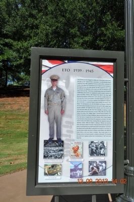
I am US Army Air Force Sergeant Joe Makowski. I first served in North Africa and Italy as a B-17 Flying Fortress crewmember in the 99th Bomber Group, Twelfth Air Force. After completing 52 missions with the 99th, I could have . . . — — Map (db m85493) HM WM
On Dexter Avenue east of South Perry Street, on the right when traveling east.
Greek immigrant Christopher Anastasios Katechis opened Chris’ Hot Dogs on May 1, 1917, at 138 Dexter Avenue. Until the 1960’s, Chris offered curb service for its hot dogs, leading to long lines of cars cued for service. The hot dogs featured Chris’ . . . — — Map (db m103243) HM
First United Methodist Church
Jasper
Methodism came to Jasper with the city's founder, Dr. Edward Gordon Musgrove, who donated land for the courthouse and for most of downtown Jasper. In 1826, he and others constructed a building of large . . . — — Map (db m29981) HM
William Brockman Bankhead served Alabama in the U.S. Congress from 1917 until 1940. For the last four years of his life, during Franklin D. Roosevelt's presidency, he served as the 47th Speaker of the House. He was the son of U.S. Senator John . . . — — Map (db m29980) HM
[Written on the initial marker, provided for context]
Our Constitution names the President of the United States the Commander in Chief of all the Armed Forces. Presidents who have served in our military are displayed on the following . . . — — Map (db m92421) HM WM
Shortly after Arkansas was admitted to the Union in 1836, the Federal government established the Little Rock Arsenal for the storage of munitions and weapons in defense of the frontier. Eventually, more than thirty buildings were constructed on . . . — — Map (db m117241) HM
On California Route 41 at Portola Road, on the left when traveling west on State Route 41.
Throughout history patriotic Americans have been drawn together to serve a cause greater than themselves. Some came because of common experiences. Most came because of common values. All came because they shared a dream.
The people who . . . — — Map (db m61431) WM
On Scenic U.S. 50/287 at State Highway 196, on the right when traveling west on U.S. 50/287Scenic .
Indian Artifacts Our artifacts date from Paleo Indians to the last of the Cheyenne and Arapaho in the region. The Sand Creek collection includes bullets, arrowheads, cannonball fragments and campsite artifacts. It is the largest display . . . — — Map (db m213692) HM
Near Scenic U.S. 50/287 at State Highway 196, on the right when traveling west.
The Story Begins… in 1922 when Mrs. John Trigg Moss representing the National Society of the Daughters of the American Revolution and Harry Truman joined forces to petition Congress to designate a "National Old Trails Road," . . . — — Map (db m213698) HM
On Broad Street at State Street, on the right when traveling north on Broad Street.
Korea Memorial
Freedom is not free
I will never leave you or forsake you
Hebrews 13 5
In my generation this was not the first occasion
when the strong attacked the
weak. Communism was acting in Korea just as
Hitler, Mussolini and . . . — — Map (db m170213) WM
On Memorial Drive at South Street (Connecticut Route 53), on the left when traveling south on Memorial Drive.
Korean War
1950 – 1953
to those who died
Honor and Eternal Rest
to those still missing
Rememberance and Hope
to those who returned
Gratitude and Peace
[Inscribed on the left panel]
Danbury . . . — — Map (db m23404) WM
On Broad Street at Court Street, on the right when traveling south on Broad Street.
Bbr>Within these brownstone walls, choirs sang hymns, teenagers learned astronomy, and – eventually – Middletown residents of all ages borrowed books.
Although this building has housed the Russell Library for well over a century, it . . . — — Map (db m71116) HM
On Division Avenue Northeast at Foote Street Northeast, on the right when traveling north on Division Avenue Northeast.
Across the street is Watts Branch, an actively used creek that has tied together many communities. Unfortunately humans have not always been respectful of this resource. The stream has experienced cycles of neglect and rejuvenation.
In . . . — — Map (db m130776) HM
On T Street Northwest west of Florida Avenue Northwest, on the right when traveling west.
This hill, with its sweeping views of Washington and the Potomac, has tantalized visionaries since the 1800s. But few of their plans have been built. In 1873 businessman and city commissioner Thomas P. Morgan (whose name survives as part of . . . — — Map (db m93415) HM
On Columbia Road Northwest north of Euclid Street Northwest, on the right when traveling south.
Furs by Gartenhaus and truffles by Avignon Freres. Hand-crafted ice cream from Budd's. Beginning in the 1910s, such neighborhood favorites occupied the commercial buildings to your right developed by Sanner and Barr. These fashionable shops . . . — — Map (db m130708) HM
On Livingston Street Northwest east of Connecticut Avenue Northwest, on the right when traveling west.
The Excitement Builds
What a day! As the streetcar pulls up excitement fills the air. Opening day at Griffith! Just 10 cents will get us where we want to be. Everyone is thrilled to be heading down to the game. It's a perfect day for . . . — — Map (db m115982) HM
On Pennsylvania Avenue Northwest at Jackson Place Northwest, on the right when traveling west on Pennsylvania Avenue Northwest.
From 1924 to 1938, rooms of the Lee House were the first headquarters of the reserve officers association of the United States. Founded in 1922 by General of the Armies John J. Pershing to assure an adequate national security, ROA had as an early . . . — — Map (db m4052) HM
On New York Avenue Northwest west of H Street Northwest, on the right when traveling west.
This church, one of the Nation’s most historic, traces its beginnings to a small group of Scottish stonemasons meeting in a carpenter’s shop on the grounds of the White House during its construction in 1793. Many prominent Americans, including . . . — — Map (db m122257) HM
On Pennsylvania Avenue Northwest at Jackson Place Northwest, on the right when traveling west on Pennsylvania Avenue Northwest.
White House policeman who gave his life in defense of the President of the United States here at the Blair House, November 1, 1950 "For loyalty, bravery and heroism beyond the call of duty." Presented by National Sojourners in commemoration of his . . . — — Map (db m73876) HM
On 14th Street Northwest north of Constitution Avenue Northwest (U.S. 1/50), on the right when traveling north.
The Ronald Reagan Building and International Trade Center honoring the 40th president, filled the last open space in the Federal Triangle. When former First Lady Nancy Reagan dedicated it in 1998, the redevelopment of this area of . . . — — Map (db m57205) HM
On Wisconsin Avenue Northwest at N Street Northwest, on the right when traveling south on Wisconsin Avenue Northwest.
Among the first businesses in historic Georgetown were its inns and taverns. They not only offered food, drink and lodging, but were focal points of community life where political debate and civic meetings took place and business deals were made. . . . — — Map (db m121195) HM
Near R Street Northwest just east of 30th Street Northwest, on the left when traveling east.
Co-founder of Czecho-Slovakia. Envoy to France. Pillar of the League of Nations. Advisor to the US presidents W. Wilson, F.D. Roosevelt, H.S. Truman. — — Map (db m189271) HM
On G Street Northwest west of 12th Street Northwest, on the right when traveling east.
As founder and 37-year president of the American Federation of Labor (AFL), Samuel Gompers is credited with winning unprecedented rights and protections for the American worker. Never wavering in his belief that power for the worker lay in . . . — — Map (db m92227) HM
On 6th Street Northwest at Fairmont Street Northwest on 6th Street Northwest.
The body of water that inspired the line in Howard University’s alma mater, “far above the lake so blue stands old Howard firm and true,” is McMillan Reservoir, which opened in 1902 to supply water to the city. The reservoir and . . . — — Map (db m130766) HM
On 17th Street Southwest north of Independence Avenue Southwest, on the left when traveling north.
Here in the presence of Washington and Lincoln, one the Eighteenth Century father and the other the Nineteenth Century preserver of our nation, we honor those Twentieth Century Americans who took up the struggle during the Second World War and made . . . — — Map (db m4392) HM
Near Ohio Drive Southwest south of West Basin Drive Southwest, on the right when traveling north.
Voters did not know the seriousness of Franklin Roosevelt's heart disease when they elected him to a fourth presidential term. With victory in sight, FDR made a final trip to Eastern Europe and the Middle East. At Yalta, he negotiated post-war . . . — — Map (db m197635) HM
Near Waldo Road (State Road 24) 0.3 miles north of Northeast 39th Avenue (Road 222), on the right when traveling north.
John Richardson "Johnny" Alison was born in Micanopy, Florida, on November 12, 1912. He was a highly decorated flying ace and served in both theaters of World War II. Johnny Alison graduated from Gainesville High School in 1931 and the University of . . . — — Map (db m101412) HM
Near Harrison Street at Riveredge Boulevard, on the left when traveling west.
Born 20 December 1929 at New Smyrna, Florida. Moved to Brevard County March 15, 1936. A 1948 graduate of Cocoa High School. Enlisted in the U.S. Army July 25, 1950. Killed in action June 24, 1951. His grave in Pinecrest Cemetery is properly marked. . . . — — Map (db m145975) HM WM
Near Main Street (Florida Route 19) at Clark Road, on the right when traveling north.
Robert M. McTureous, Jr. Private United States Marine Corps Born: March 26, 1924 Killed in Action: June 1945 Awarded his country’s highest award The Medal of Honor ”For conspicuous gallantry and intrepidity at the risk of his life above . . . — — Map (db m167318) WM
On Granada Boulevard north of Southwest 40 th Street (State Road 976), on the left when traveling north.
Ruth Bryan Owen was the daughter of famed orator and Democratic presidential nominee William Jennings Bryan. She was born in Jacksonville, Illinois, on October 2, 1885. During World War I, she served as a nurse in the Egyptian-Palestine campaign. . . . — — Map (db m82381) HM
Near Wall Street at Tiftss Street, on the left when traveling north.
Harry Truman born in Lamar, MO., was a farmer, army officer, county official and judge in Missouri before his election as a United States Senator in 1934. Truman was elected Vice President when President Franklin D. Roosevelt was re-elected for a . . . — — Map (db m222857) HM
On Caroline Street, 0.1 miles south of Roberts Lane, on the right when traveling north.
During his tenure in office as President
of the United States, Harry S. Truman
visited Key West a total of 11 times
commencing in 1946.
It was at this restaurant that President Truman would stop and enjoy a cup of coffee while taking one of . . . — — Map (db m224447) HM
On Front Street, on the right when traveling south.
Built in 1890 on the waterfront as a two-family dwelling for the base commandant and paymaster, this building was known as Quarters A and B. It was converted into a single-family residence in 1911. President William Howard Taft visited this site in . . . — — Map (db m32659) HM
On Front Street at Caroline Street, on the right when traveling south on Front Street.
Built in 1890 as quarters for Navy officers, the Little White House later was used by American Presidents William Howard Taft, Harry S. Truman, Dwight Eisenhower, John F. Kennedy, Jimmy Carter and Bill Clinton. Truman used the facility as a vacation . . . — — Map (db m32655) HM
On Front Street north of Admirals Lane, on the left when traveling north.
This house was built for
the commanding officer
of the Key West
Submarine Base, but it was
President Harry S. Truman's
use of the site for working
vacations that earned it fame
as "The Little White House."
During Truman's 11 trips
here from . . . — — Map (db m192419) HM
Near Willing Street, 0.1 miles west of Caroline Street.
July 10, 1950
Battle of Chochiwon
July 19, 1950
Battle of Taejon
August 4, 1950
Battle of the Pussan Perimeter
September 16, 1950
The Pohang Breakout
November 27, 1950 . . . — — Map (db m153182) WM
Near Willing Street, 0.1 miles west of Caroline Street.
December 7, 1941
Japan Attacks Pearl Harbor
December 11, 1941
Italy & Germany Declare War On U.S.
April 10, 1942
Bataan Death March
August 7, 1942
U.S. Troops Land On Guadalcanal . . . — — Map (db m152490) WM
Near Seminole Boulevard north of North Park Avenue, on the right when traveling west.
At the end of World War II, Korea was divided into two parts, north and south, at the 38th parallel. Troops from the Soviet Union occupied the north and the United States forces occupied the south with the intention of eventually unifying the . . . — — Map (db m74149) HM
Near East Orange Avenue, 0.1 miles east of South Beach Street, on the left when traveling east.
Just as carefully as Branch Rickey chose Jackie Robinson, he chose Daytona Beach as the site for his "noble experiment.” Dr. Mary McLeod Bethune, founder of Bethune-Cookman College was born July 10, 1875, in Maysville, South Carolina. She was . . . — — Map (db m106464) HM
Near Bartlett Street at St Marys Street West, on the left when traveling north.
President Harry S. Truman called The War of 1812 “the silliest damned war we ever fought. It should have been resolved through diplomacy.” Nevertheless, Congress declared war against Great Britain on June 18, 1812. The war was mainly . . . — — Map (db m145198) HM
Near Main Street (Love Avenue) (U.S. 41) just north of 1st Street East, on the left when traveling north.
Lt. Col. Henry Tift Myers was born in the Myon Hotel in Tifton on September 16, 1907. He graduated from Culver Military Academy in 1925 and the University of Georgia in 1929. He joined the Army Air Corps, graduating at the top of his class in 1932. . . . — — Map (db m197699) HM
On U.S. 78 at Locklin Road, on the right when traveling east on U.S. 78.
2.4 miles east, at Moore’s Ford Bridge on the Apalachee River, four African-Americans - George and Mae Murray Dorsey and Roger and Dorothy Dorsey Malcom (reportedly 7 months pregnant) - were brutally beaten and shot by an unmasked mob on the . . . — — Map (db m19775) HM
On Cowpens Street, on the left when traveling north.
He was aggressive in war without hate; he never forgot that he was dealing with human beings, on both sides of the conflict. (E.R. Potter, 1976)
Born to Frederickburg, Texas in 1885, Chester W. Nimitz was accepted into the United States naval . . . — — Map (db m73127) HM
Excluded from their west coast homes by military authorities, more than 9000 Japanese Americans occupied Hunt Relocation Camp 4 miles north of here between 1942 & 1945.
Until they could resettle in other places, they live in wartime tarpaper . . . — — Map (db m61972) WM
Legion of Merit Chief Commander
General Dragoljub Mihailovich distinguished himself in an outstanding manner as Commander-in-Chief of the Yugoslavian Army Forces and later as Minister of War by organizing and leading important resistance . . . — — Map (db m55566) HM
On East Wesley Drive at Prairie Crossing when traveling west on East Wesley Drive.
"Our debt to the heroic men and valiant women in the service of our country can never be repaid. They have earned our undying gratitude: America will never forget their sacrifices."
Harry S. Truman, 1945
On West Park Drive (Business U.S. 24) 0.1 miles west of Dimond Street, on the right when traveling west.
James Robert Adams •
Leonard D. Ahner •
Charles R. Appier •
Maurice J. Barnes •
John A. Beeson •
John R. Bickel •
Frank Eugene Bowman •
Paul Dee Bouman •
Donald L. Brewer •
Phillip Brewer •
Ralph J. Bright •
Geral H. . . . — — Map (db m161510) WM
On West Walnut Street east of North Capital Avenue, in the median.
Franklin Delano Roosevelt (FDR) and Anna Eleanor Roosevelt (AER) were one of the first power couples in American politics. FDR's sweeping vision helped rescue the United States from the worst economic depression in its history and led the country . . . — — Map (db m132850) HM
On North Meridian Street north of East North Street, on the right when traveling north.
In Memory of Those Who Gave Their Lives
August 5, 1950
Hi Folks,
Things are going smooth here today and it wouldn't hurt my feelings any if they stayed that way.
Your loving son,
Jim
(James W. Farmer)
Killed in . . . — — Map (db m132839) WM
On North Pennsylvania Street north of East North Street, on the right when traveling south.
A World at War
History records that World War II began in earnest on September 1, 1939, when German troops invaded Poland. Treaty allies Great Britain and France declared war on Germany. Italy, already branded an aggressor for its campaign . . . — — Map (db m132860) WM
On East Georgia Street west of South Meridian Street, in the median.
Pyle was born August 3, 1900, near Dana, Ind. After studying journalism at Indiana University. Pyle worked as a newspaper reporter with the LaPorte Herald. He later wrote a daily aviation column for the Washington Daily News. In 1935, he became a . . . — — Map (db m132823) HM
1886 - - - - - 1952
President
United Steelworkers of America
1936 - 1952
Congress of Industrial Organization
1940 - 1952
Philip Murray went into the coal mines as a boy of 16. By 1916 he had risen through the ranks of . . . — — Map (db m58560) HM
On the Public Square at 1st Street, on the left when traveling east on the Public Square.
Thank You Veterans For Our Freedom
Our debt to the heroic men and valiant women of our country can never be repaid. They have earned our undying gratitude. America will never forget their sacrifices.
President Harry S. . . . — — Map (db m72443) WM
On Memorial Drive, 0.1 miles east of West Campus Road, on the left when traveling east.
This memorial commemorates the conflict that began on June 25, 1950 when North Korean military forces crossed the 38th Parallel and launched a massive invasion of South Korea. Responding to pleas for help by the Government of the Republic of . . . — — Map (db m77589) WM
On West 18th Street (State Highway 57) at North Adams Street, on the right when traveling west on West 18th Street.
Section 1 Top Tablet United States Army The Chief of Staff October 27, 2000 The Junction City - Fort Riley Community and the Buffalo Soldiers I would like to take this opportunity to congratulate the Junction City-Fort Riley community . . . — — Map (db m44250) HM
On River Street north of Bridge Street, on the right when traveling north.
(side 1)
Rails of Louisville, St. Louis, and Texas Railroad laid here June 9, 1888. First passenger train ran between Owensboro and Stephensport Oct. 7, 1888. Service between Evansville and Louisville began in April 1889. Rail line . . . — — Map (db m119799) HM
On Dixie Highway (Kentucky Route 31W/60), on the right when traveling south.
Fort Knox is one of the Army’s major installations. Run by the Army’s Installation Management Agency, it is home to several major commands including the United States Army Armor School and Center and United States Army Recruiting Command, both . . . — — Map (db m126196) HM
On Laurel Road (U.S. 25) at Roaden Lane, on the right when traveling north on Laurel Road.
(side 1)
First Lt. Carl H. Dodd
This Medal of Honor recipient was born in Harlan Co. Dodd served with Co. E, 5th Regimental Combat Team, U.S. Army. He was awarded the medal for heroic action in the Korean War for capture of Hill . . . — — Map (db m62761) HM
On South Main Street at East 4th Street (Kentucky Route 3519), on the left when traveling north on South Main Street.
Civil Rights Activist Author
In 1948, Alice Dunnigan was first black reporter on campaign trail with a president--Truman. Under Presidents Kennedy and Johnson, she was member of President's Committee on Equal Opportunity. Author of: A . . . — — Map (db m123369) HM
On Lone Oak Road (U.S. 45) at Carson Road, on the right when traveling south on Lone Oak Road.
Alben W. BarkleyAlben W. Barkley, Vice President of United States, 1949-53. Member U. S. Senate, 1927-49 and 1955-56; Senate Democratic leader 13 years; House of Representatives 1913-27. Born Lowes, Ky., 1877. Came to Paducah 1898. Elected to . . . — — Map (db m233372) HM
Alben William Barkley (1877~1956)
Elected McCracken County Attorney, County Judge, U.S. Representative, and U.S. Senator, Barkley served Harry Truman as Vice-President and was known as the "Veep". He was re-elected to the U.S. Senate in 1955. . . . — — Map (db m49749) HM
Near University Boulevard south of Elizabeth Avenue, on the right when traveling south.
A native of nearby Morgan County, Capt. Barber received our nation's highest decoration for bravery for heroically leading his Marine rifle company in a desperate five-day defense of a frozen mountain pass vital to the 1st Marine Division's . . . — — Map (db m120060) HM WM
Side 1 A Williamsburg native and Ky. State Univ. student, he was a World War II Tuskegee Airman and B-25 navigator and bombardier. He participated in the 1945 "Freemen Mutiny" where 101 black officers fought inequality by entering a . . . — — Map (db m74178) HM
Near South Irma Boulevard, 0.3 miles north of East Worthey Street, on the right when traveling north.
U.S. President Woodrow Wilson had lofty goals for World War I, including his hope that the war would create a set of conditions that made future wars impossible. Along with his plea that the war should be fought "to make the world safe for . . . — — Map (db m114884) HM WM
Near South Irma Boulevard north of East Worthey Street, on the right when traveling north.
During the first year of the Korean War, President Harry Truman and General Douglas MacArthur, the man Truman put in charge, started to have fundamental disagreements about the methods and overall purpose of the war. MacArthur came to believe that . . . — — Map (db m114991) HM WM
Near South Irma Boulevard, 0.3 miles East Worthey Street, on the right when traveling north.
Panel 1 The Korean War (June 25, 1950 - July 27, 1953) erupted in 1950 when the Democratic People's Republic of Korea (North Korea) invaded the Republic of Korea (South Korea). What started as a civil war quickly turned into a matter of . . . — — Map (db m115122) HM
Near South Irma Boulevard, 0.3 miles north of East Worthey Street, on the right when traveling north.
Panel 1 Much like the Korean War before it, the Vietnam War started as a civil war in Asia, but quickly evolved into an international matter because it became yet another manifestation of the Cold War. By 1954, a communist regime controlled . . . — — Map (db m208813) WM
Near South Irma Boulevard, 0.3 miles north of East Worthey Street, on the right when traveling north.
Post Pearl Harbor American and British military planners decided on a strategy of “Europe First", but that did not mean “Neglect Japan Entirely.” Indeed, fierce fighting took place in the Pacific in the immediate aftermath . . . — — Map (db m115786) HM WM
On Fairfield Avenue at Kirby Place, on the right when traveling north on Fairfield Avenue.
Begun in 1903 by lumberman T.M. Jones. Remodeled to present appearance 1919 by oilman J.P. Evans. Architect Ed Neild, Sr. used its interior moldings as models for White House under President Truman. Property originally part of Mighty Haag Circus . . . — — Map (db m138882) HM
In the mid-1800s, when South Portland was still a part of Cape Elizabeth, its waterfront appeared to be a continuous line of bustling yards building and repairing ships. From Butler on Turner's Island to Knight and Blanchard in Knightville to . . . — — Map (db m50413) HM
Class of 1897, United States Naval Academy
USS Oregon, Battle of Santiago, 3 July 1898
Chief, Bureau of Ordnance, 1927-1931
Commander, Destroyers, Scouting Force, 1931-1933
Chief, Bureau of Navigation, 1933-1935
Vice Admiral, . . . — — Map (db m114852) HM WM
On Governor Ritchie Highway (State Highway 450) at Chase Road, in the median on Governor Ritchie Highway.
[Marker Panel No. 1]:
Introduction
With their lives before them, they left everything – their families, their loved ones, the serenity and security of their homes – to fight for a just cause. They departed on a journey to places they . . . — — Map (db m14703) HM
The forts walls are called ramparts. An American flag flies over Fort McHenry twenty four hours a day by Presidential Proclamation.
The size of the flag varies. On clear days with the right amount of wind, a full-size replica of the . . . — — Map (db m61434) HM
On Pennsylvania Avenue at Jonathan Street, on the right when traveling north on Pennsylvania Avenue.
About 200,000 African-Americans served in the Civil War. When the army reorganized at the end of the war, it established six regiments in the regular army to be composed of African-American recruits. The 9th and 10th Cavalry Regiments and four . . . — — Map (db m159782) HM
Near Ocean St, 0.2 miles north of Gosnold St, on the left when traveling south.
This memorial honors the Korean War veterans from Cape Cod and the Islands. The white bricks in the pathway immortalize those who were killed in action or died while missing.
One and one half million Americans served in Korea; 129,000 were . . . — — Map (db m142955) HM
On Main Street (U.S. 20) at Academy Street, on the right when traveling north on Main Street.
James Burt
Veterans Memorial Park
In Memory of Those from Lee Who Died During War
For Their Country
World War I
1917 – 1918
James R. Bossidy • John T. Carty • Thomas M. Crerar • Russell R. Griffin • Thomas J. Fanning • Harry F. . . . — — Map (db m85004) HM
On Western Avenue (Route 127) at Essex Avenue (Massachusetts Route 133), on the left when traveling north on Western Avenue.
[ inscribed around the base of the globe ]
We Fought For Freedom Around The World
[ plaque on central column ]
Gloucester
Remembers
1941 – World War II – 1945
The people of Gloucester proudly dedicate this . . . — — Map (db m36768) HM
"We've been looking for the enemy for some time now. We've finally found him. We're surrounded. That simplifies things." — Colonel Lewis B. "Chesty" Puller
The United Nations Offensive had been a story of . . . — — Map (db m151869) HM
On Front Street just east of Foster Street, on the right when traveling west.
"We were alerted for Korea and I remember it very clearly. We would be gone a couple of weeks at the most to make a show of force, a parade in Korea, then back to Japan." — U.S. Soldier of the 34th Infantry . . . — — Map (db m151872) HM
Near Front Street at Commercial Street, on the left when traveling west.
The Japanese Empire, like its European ally Germany, was determined to expand its control in East Asia by "annexing" territory and asserting control over the region. Japan took advantage of the European war to invade and seize French, Dutch, and . . . — — Map (db m151791) HM
On West Western Avenue (U.S. 31) 0.1 miles north of Seventh Street, on the right when traveling north.
The Union Depot opened in 1895 to serve the Chicago & West Michigan Railway; the Muskegon, Grand Rapids & Indiana Railroad; and the Toledo, Saginaw & Muskegon Railroad.
A.W. Rush and Son of Grand Rapids designed the Richardson Romanesque . . . — — Map (db m107240) HM
Near West Main Street (State Highway 21) east of Curwood Castle Drive.
[Panel 1]
In 1833, Owosso's founding fathers overlooked this river and envisioned a beautiful city on its banks. Thousands of years before, the river course was formed as the last glaciers retreated north. The Chippewas named it . . . — — Map (db m240993) HM
On Military Street (Business Interstate 69/94) at Wall Street, on the right when traveling north on Military Street.
Harrington Hotel
The Harrington Hotel opened amid much fanfare in 1896.
A unique blend of Romanesque, Classical and Queen Anne architecture, the hotel thrived for many years. As business declined due to the popularity of automobile . . . — — Map (db m212536) HM
On Bush Avenue west of Forest Street North, on the right when traveling west.
Setting the Cornerstone, Building 21
President William L. McKnight, accompanied by chief engineer E. M. Johnson, supervised the installation of the cornerstone in October 1939.
The mason worked for the William Murphy and Son Construction . . . — — Map (db m151373) HM
On Xenwood Avenue at South Frontage Road, on the left when traveling south on Xenwood Avenue.
During World War II, some 5,000-6,000 Japanese American soldiers, members of the U.S. Army's Military Intelligence Service, were given intensive and accelerated classes in the Japanese language at Camp Savage.
Their subsequent work translating . . . — — Map (db m41673) HM
Near County Road 101 (Business U.S. 169) at Sarazin Street, on the right when traveling west.
For many years, steamboats along the Minnesota River were the most efficient way for people and goods to reach the young city. However, in the mid-1860s, a new method of transportation arrived — the railroad. The first steam train rolled from . . . — — Map (db m213160) HM
On Riverside Drive, 0.1 miles north of Hillsdale Street, on the left when traveling south.
Once on this site there stood a beautiful red brick and limestone railway station that was part of the great Chicago, Rock Island and Pacific Railway System. It was a stately building that served our community and the Rock Island System proudly for . . . — — Map (db m23173) HM
On Sgt John Pittman Drive at Medallion Drive, on the right when traveling west on Sgt John Pittman Drive.
The Medal of Honor is the highest award for valor in action against an enemy force which can be bestowed upon an individual serving in the Armed Services of the United States of America. Sgt. Pittman earned this medal by his actions in Korea on 26 . . . — — Map (db m62805) WM
On Turner Street (State Highway 63) at Azalea Drive (State Highway 184), on the right when traveling south on Turner Street.
Lt. Lindsey was awarded the 100th Congressional Medal of Honor given in World War II. Presented by Pres. Truman, Lindsey was the only recipient to ever receive the award before a Joint Session of the Congress. — — Map (db m80370) HM
On Clark Street (U.S. 54) at Hendy Street, on the right when traveling north on Clark Street.
On March 5, 1946, at Westminster College in Fulton, MO, Winston Churchill delivered his renowned "Iron Curtain" Speech. Allen P. Green built this gate in anticipation of a visit to his home by the former British Prime Minister and President Harry . . . — — Map (db m70531) HM
On 11th Street near Truman Street, on the left when traveling east.
Born Lamar, Missouri May 8, 1884
Died Kansas City, Missouri December 26, 1972
Patriot - Statesman - Legionnaire
First Legionnaire President
of the United States
This memorial was erected in May 1984 by
Legionnaires and Friends of the . . . — — Map (db m37140) HM
On 11th Street at Truman Street, on the left when traveling east on 11th Street.
This shrine is dedicated to
Harry S. Truman
Thirty second President
of the United States of America
who was born at this location
May 8, 1884
[died] Dec. 26, 1972
"I ask only to be a good and faithful
servant of . . . — — Map (db m37113) HM
On Gulf Street at 11th Street West, on the right when traveling north on Gulf Street.
Side A
Lamar is distinguished as the birthplace of Harry S. Truman, the 33rd President of the United States. The son of John Anderson Truman and Martha Ellen (Young) Truman, he was born May 8, 1884. The family moved to Harrisonville in Cass . . . — — Map (db m42286) HM
On Missouri Route 18, 0.2 miles east of Exit 141 (Interstate 49), on the right when traveling east.
In memory of
Veterans
World War I
and
Veterans
World War II
The Perimeter
The Perimeter is a place warriors will always seek- even for eternity. Just gaze out at our National Cemeteries, for out there, on the outer edge, . . . — — Map (db m81538) WM
On C. F. Lampkin Drive, on the right when traveling south.
In this building
5 March 1946
the Right Honorable
Winston Churchill
Wartime Prime Minister of
Great Britain
delivered his
"Iron Curtain" Speech
having been introduced by
Harry S. Truman
President of the
United . . . — — Map (db m70417) HM
George Washington Carver (1864-1943) was born in Diamond Grove, MO. As an agricultural chemist and inventor at Tuskegee Institute, now Tuskegee University, in Alabama, he developed a system of crop rotation. He also discovered 300 uses for . . . — — Map (db m192155) HM
225 entries matched your criteria. The first 100 are listed above. Next 100 ⊳