16200 entries match your criteria. The first 100 are listed. ⊳
Entries Containing the Word «battle»
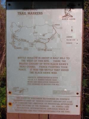
By Keith L, October 7, 2009
Black Hawk Historic Trail Markers
RANKED BY RELEVANCE, THEN GEOGRAPHICALLY
| 1 ► Wisconsin, Vernon County, De Soto — 8 CVP — Black Hawk War — Battle Bluff · Battle Hollow · Battle Island — |
| On Great River Road (State Highway 35) 2.5 miles north of Main Street (State Highway 82), on the right when traveling north. | |||
| 2 ► United Kingdom, England, East Sussex, Battle — The Battle of Hastings and Battle Abbey — Battle of Hastings, 1066 — |
| Near High Street at Park Lane, on the right when traveling south. | |||
| 3 ► Alabama, Russell County, Phenix City — Before The Battle / Battle Of Girard — |
| On 14th Street at 5th Avenue, on the left when traveling west on 14th Street. | |||
| 4 ► Florida, Baker County, Olustee — Battle of Ocean Pond (or The Battle of Olustee) — |
| Near Battlefield Trail, 0.2 miles north of U.S. 90. | |||
| 5 ► Georgia, Coweta County, Newnan — The Battle of Brown's Mill: Detour to Battle — Brown's Mill Battlefield — |
| Near Millard Farmer Road, 0.4 miles east of Old Corinth Road, on the right when traveling east. | |||
| 6 ► Kentucky, Harrison County, Cynthiana — 2312 — 1st Battle of Cynthiana / 2nd Battle of Cynthiana — |
| On Paris Pike (U.S. 27), on the left when traveling south. | |||
| 7 ► Louisiana, De Soto Parish, Mansfield — Battle of Mansfield or Sabine Cross Roads — April 8. 1864 — Confederate Battle Line at 4:00 P.M.~First Phase of Battle — |
| On Louisiana Route 175, 0.3 miles north of Parish Road 48, on the right when traveling north. | |||
| 8 ► Mississippi, Claiborne County, Bruinsburg — Battle of Port Gibson – The Battle — Windsor Battlefield Tour — |
| On State Highway 552 at Russum Westside Road, on the right when traveling north on State Highway 552. | |||
| 9 ► Mississippi, Lee County, Baldwyn — Interpretive Sites — Battle of Brice's Crossroads • June 10, 1864 Battle of Tupelo • July 13-15, 1864 — |
| On Grisham Street, 0.4 miles south of Bethany Road (Mississippi Highway 370), on the right when traveling south. | |||
| 10 ► Ohio, Mercer County, Fort Recovery — 12 — Weaponry at the Battle of the Wabash and the Battle of Fort Recovery — |
| On East Boundary Street east of Wayne Street, on the right when traveling east. | |||
| 11 ► Pennsylvania, Westmoreland County, Mount Pleasant — Battle of Midway - Battle Of Iwo Jima - Uncomon Valor — |
| On West Main Street (Pennsylvania Route 31) at South Diamond Street (Pennsylvania Route 819), on the right when traveling east on West Main Street. | |||
| 12 ► Tennessee, Henderson County, Parkers Crossroads — Prelude to Battle/December 31, 1862—the Battle/Union and Confederate Forces — |
| On Wildersville Road, 0.2 miles east of Tennessee Route 22, on the right when traveling east. | |||
| 13 ► Virginia, Frederick County, Winchester — 2nd Battle of Winchester / 3rd Battle of Winchester — |
| On Martinsburg Pike (U.S. 11) just north of Brooke Road (Virginia Route 1322), on the right when traveling south. | |||
| 14 ► Virginia, Petersburg — Siege of Petersburg—Lee Strikes Back — March 25, 1865 Battle of Fort Stedman to Battle of Jones Farm — |
| On Siege Road, 2.4 miles south of Oaklawn Boulevard (Virginia Route 36), on the right when traveling south. | |||
| 15 ► Maryland, Anne Arundel County, Annapolis — Norman Scott Natatorium — Named in honor of Rear Admiral Norman Scott, U.S. Navy — U.S.N.A. Class of 1911 — |
| On Cooper Road just south of Holloway Road. | |||
| 16 ► Missouri, Clay County, Liberty — Civil War Memorial — |
| Near East Mississippi Street, 0.1 miles east of North Jewell Street. | |||
| 17 ► Missouri, Clay County, Liberty — Mass Grave Site — |
| Near East Mississippi Street, 0.1 miles east of North Jewell Street. | |||
| 18 ► New Jersey, Mercer County, Hamilton Township, Mercerville — 6 of 12 — Route of Washington’s March — |
| On Quakerbridge Road, 0.2 miles north of Flock Road, in the median. | |||
| 19 ► New Jersey, Mercer County, Hamilton Township, Mercerville — 3 of 12 — Route of Washington’s March — |
| Near Hamilton Ave. | |||
| 20 ► New Jersey, Mercer County, Hamilton Township, Mercerville — 8 of 12 — Route of Washington’s March — |
| On Quakerbridge Road at Hughes Drive, on the right when traveling north on Quakerbridge Road. | |||
| 21 ► New Jersey, Mercer County, Hamilton Township, Mercerville-Hamilton Square — 5 of 12 — Route of Washington’s March — |
| 22 ► New Jersey, Mercer County, Hamilton Township, Mercerville-Hamilton Square — 4 of 12 — Route of Washington’s March — |
| On Klockner Road, 0.1 miles north of Hamilton Avenue, on the right when traveling north. | |||
| 23 ► New Jersey, Mercer County, Lawrence Township — 9 of 12 — Route of Washington’s March — |
| On Quakerbridge Road just north of Nassau Park Boulevard, in the median. | |||
| 24 ► New Jersey, Mercer County, Princeton — 10 of 12 — <br>Route of Washington’s March — |
| On Quaker Road, on the right. | |||
| 25 ► New Jersey, Mercer County, Princeton — 11 of 12 — Route of Washington’s March — |
| On Quaker Road, on the right when traveling north. | |||
| 26 ► New Jersey, Mercer County, Princeton, Princeton Township — 12 of 12 — Route of Washington’s March — |
| 27 ► New Jersey, Mercer County, Trenton, Mercerville — 7 of 12 — Route of Washington’s March — |
| On Youngs Road, 0.1 miles west of Quakerbridge Road, on the right when traveling east. | |||
| 28 ► Virginia, Prince William County, Manassas — George T. Stovall — |
| Near Sudley Road (Virginia Route 234). | |||
| 29 ► Belgium, Vlaams Gewest, Oost-Vlaanderen, Oudenaarde — Oudenaarde American Monument — 37th and 91st U.S. Divisions Regional Activities — |
| On General Pershingstraat close to Gevaertsdreef, on the left when traveling north. | |||
| 30 ► Belgium, Vlaams Gewest, West-Vlaanderen, Vierstraat — Kemmel American Monument — 27th and 30th U.S. Divisions in the Ypers-Lys Offensive — |
| On Kemmelstraat (Route N331) 0.3 kilometers west of Vierstraat. | |||
| 31 ► France, Grand Est, Marne, Saint-Étienne-à-Arnes — Sommepy American Monument — The Blanc Mont Offensive — |
| Near Route D320 at Unmarked. | |||
| 32 ► France, Grand Est, Meuse, Montfaucon-d'Argonne — Montfaucon American Monument — The Meuse-Argonne Offensive — |
| On D15A, on the right when traveling west. | |||
| 33 ► France, Grand Est, Meuse, Montsec — Montsec American Monument — The St. Mihiel Salient — |
| On Montsec Monument Access Road just west of D12. | |||
| 34 ► France, Grand Est, Meuse, Romagne-Sous-Montfaucon — Meuse-Argonne American Cemetery — |
| On Rue du General Pershing (D123). | |||
| 35 ► France, Hauts-de-France, Aisne, Château-Thierry — American Aisne-Marne Memorial — |
| On Route du Monument, 1.3 kilometers south of Route de Paris (Route D1003). | |||
| 36 ► France, Hauts-de-France, Somme, Cantigny — Cantigny American Monument — |
| On Rue Saint Aignan (Route D26), on the left when traveling north. | |||
| 37 ► Luxembourg, , Luxembourg City — Military Operations in Western Europe — 6 June 1944—8 May 1945 — |
| On Val du Scheid. | |||
| 38 ► Philippines, Calabarzon, Cavite, Corregidor Island — General Jonathan M. Wainwright Memorial — |
| Near Bottomside Tour Route at Wainwright Park. | |||
| 39 ► Philippines, Metro Manila, Manila, Taguig — Manila American Cemetery and Memorial — The American Battle Monuments Commission — |
| 40 ► United Kingdom, England, Greater London, City of Westminster — The Battle of Britain Memorial — |
| On Victoria Embankment just north of Bridge Street, on the right when traveling north. | |||
| 41 ► United Kingdom, England, Kent, Folkestone — Battle of Britain Memorial — |
| On New Dover Road (England Route B2011) at Old Dover Road, on the right when traveling east on New Dover Road. | |||
| 42 ► Alabama, Baldwin County, Gulf Shores — "Damn The Torpedoes!" The Campaigns for Mobile, 1864 - 1865 — |
| On Fort Morgan Road (Alabama Route 180) 1.2 miles west of Dune Road, on the right when traveling west. | |||
| 43 ► Alabama, Baldwin County, Gulf Shores — Stop C4 — "The Shells Were Bursting All Around Us" — The Siege of Fort Morgan: — Stop C4 — |
| Near Fort Morgan Road, 1.4 miles Dune Road, on the left when traveling west. | |||
| 44 ► Alabama, Mobile County, Citronelle — 14 — "Having Surrendered Their Arms, the War, to Them, Was Over" — Citronelle, Surrender Site — The Battle of Mobile Bay Civil War Trail — |
| On Celeste Road (County Route 41) 0.3 miles north of Boy Scout Road, on the right when traveling north. | |||
| 45 ► Alabama, Mobile County, Dauphin Island — Stop E — "Save Your Garrison." — Bombardment of Fort Powell: — Stop E — |
| Near Bienville Boulevard east of Albatross Street, on the right when traveling east. | |||
| 46 ► Alabama, Mobile County, Dauphin Island — Stop D — "To Be Blown To Kingdom Come" — Siege of Fort Gaines — Stop D — |
| Near Bienville Boulevard east of Albatross Street, on the right when traveling east. | |||
| 47 ► Alabama, Mobile County, Dauphin Island — Stop D — “Damn the Torpedoes!” — The Battle of Mobile Bay: — Stop D — |
| Near Bienville Boulevard east of Albatross Street, on the right when traveling east. | |||
| 48 ► Alabama, Mobile County, Dauphin Island — Stop 1 — Storm Clouds Gather — The Overland Campaign — Stop 1: Fort Gaines — |
| Near Bienville Boulevard east of Albatross Street, on the right when traveling east. | |||
| 49 ► Alabama, Mobile County, Mobile — "Damn The Torpedoes!" The Campaigns for Mobile, 1864 - 1865 — The Museum of Mobile — |
| On South Royal Street south of Government Street, on the left when traveling south. | |||
| 50 ► District of Columbia, Washington, Northwest Washington, Federal Triangle — A Soldier's Journey — |
| On Pennsylvania Avenue Northwest just west of 14th Street Northwest, in the median. | |||
| 51 ► District of Columbia, Washington, Northwest Washington, Federal Triangle — Americans All — |
| On Pennsylvania Avenue Northwest just west of 14th Street Northwest, in the median. | |||
| 52 ► District of Columbia, Washington, Northwest Washington, Federal Triangle — Armistice and Legacy — |
| On Pennsylvania Avenue Northwest just west of 14th Street Northwest, in the median. | |||
| 53 ► District of Columbia, Washington, Northwest Washington, Federal Triangle — Beyond the AEF — |
| On Pennsylvania Avenue Northwest just west of 14th Street Northwest, in the median. | |||
| 54 ► District of Columbia, Washington, Northwest Washington, Federal Triangle — Commerce to Commemoration — The Evolution of a City Block — |
| On Pennsylvania Ave Northwest at 15th Street Northest, on the left when traveling west on Pennsylvania Ave Northwest. | |||
| 55 ► District of Columbia, Washington, Northwest Washington, Federal Triangle — From Homefront to Battlefront — |
| On Pennsylvania Avenue Northwest just west of 14th Street Northwest, in the median. | |||
| 56 ► District of Columbia, Washington, Northwest Washington, Federal Triangle — The AEF in the Great War, 1917-1918 — |
| On Pennsylvania Avenue Northwest just west of 14th Street Northwest, in the median. | |||
| 57 ► District of Columbia, Washington, Northwest Washington, Federal Triangle — World War I Memorial — |
| On 15th Street Northwest at Pennsylvania Avenue Northwest on 15th Street Northwest. | |||
| 58 ► District of Columbia, Washington, Northwest Washington, Federal Triangle — World War I Memorial — |
| On Pennsylvania Avenue Northwest west of 14th Street Northwest, in the median. | |||
| 59 ► District of Columbia, Washington, Northwest Washington, Federal Triangle — World War I Remembered — |
| On Pennsylvania Avenue Northwest just west of 14th Street Northwest, in the median. | |||
| 60 ► District of Columbia, Washington, Northwest Washington, Federal Triangle — World War I, 1914-1917 — |
| On Pennsylvania Avenue Northwest just west of 14th Street Northwest, in the median. | |||
| 61 ► District of Columbia, Washington, Southwest Washington, The National Mall — Korean War Veterans Memorial — |
| On Daniel French Drive Southwest north of Independence Avenue Southwest, on the left when traveling south. | |||
| 62 ► District of Columbia, Washington, Southwest Washington, The National Mall — World War II Memorial — |
| On 17th Street Southwest north of Independence Avenue Southwest, on the left when traveling north. | |||
| 63 ► Florida, Brevard County, Melbourne — Battle of the Bulge — 1944 - 199 — |
| On Oak Street at East Hibiscus Boulevard, on the right when traveling north on Oak Street. | |||
| 64 ► Florida, Highlands County, Avon Park — The War Dog Memorial — |
| On West Main Street, on the right. | |||
| 65 ► Florida, Lake County, Eustis — Battle of the Bulge Memorial — |
| Near Ferran Park Drive at East McDonald Avenue, on the right when traveling south. | |||
| 66 ► Florida, Orange County, Orlando — Veterans of the Battle of the Bulge — Ardennes — |
| Near E. Robinson Street (State Road 526) at Cathcart Ave. | |||
| 67 ► Indiana, Tippecanoe County, Battle Ground — Prophet’s Town — |
| On State Road 225 at Houston Road on State Road 225. | |||
| 68 ► Kentucky, Hart County, Bonnieville — Bacon Creek Trestle — |
| On North Dixie Highway (U.S. 31W) at Morgan's Raiders Avenue, on the right when traveling north on North Dixie Highway. | |||
| 69 ► Kentucky, Hart County, Munfordville — Anthony Woodson Farm — Battle of Munfordville — September 14-17, 1862 — |
| On Charlie Downing Road north of Bragg Avenue, on the right when traveling north. | |||
| 70 ► Kentucky, Hart County, Munfordville — Battle of Munfordville: Day 1 — Battle and Siege of Munfordville — Sunday, September 14, 1862 — |
| Near Charlie Dowling Road, 0.3 miles north of S. Dixie Highway (U.S. 31W). | |||
| 71 ► Kentucky, Hart County, Munfordville — Battle of Munfordville: Siege — |
| Near Charlie Dowling Road, 0.3 miles north of S. Dixie Highway (U.S. 31W). | |||
| 72 ► Kentucky, Hart County, Munfordville — Battle of Rowletts Station — December 17, 1861 — |
| Near C. Miller Logging & Lumber Co. Driveway, 0.1 miles west of S. Dixie Highway (U.S. 31W). | |||
| 73 ► Kentucky, Hart County, Munfordville — Fort Craig — Battle and Siege of Munfordville — September 14 - 17, 1862 — |
| Near Charlie Dowling Road, 0.3 miles north of S. Dixie Highway (U.S. 31W). | |||
| 74 ► Kentucky, Hart County, Munfordville — Kentucky and the Western War — Western Theater, 1861-1862 — |
| On Charlie Downing Road north of Bragg Avenue, on the left when traveling north. | |||
| 75 ► Kentucky, Hart County, Munfordville — L&N Railroad Bridge — Constructed 1857-1859 — |
| Near Charlie Dowling Road, 0.3 miles north of S. Dixie Highway (U.S. 31W). | |||
| 76 ► Kentucky, Hart County, Munfordville — Munfordville in the Civil War — |
| On Dixie Highway / Main Street (U.S. 31W) at South Street, on the left when traveling south on Dixie Highway / Main Street. | |||
| 77 ► Kentucky, Hart County, Munfordville — Pontooniers! — 1861 - 1865 — |
| Near River Road east of Old Street, on the left when traveling south. | |||
| 78 ► Kentucky, Hart County, Munfordville — The Raider — Morgan and his Raiders — Woodsonville, 1861 — |
| On Charlie Downing Road north of Bragg Avenue, on the left when traveling north. | |||
| 79 ► Kentucky, Hart County, Munfordville — The Smith Monument — Dedicated September 17, 1864 — Battle for the Bridge Historic Preserve — |
| Near Rush Island Bend Road, 0.7 miles north of Rowletts Cave Springs Road, on the right when traveling north. | |||
| 80 ► Kentucky, Hart County, Munfordville — The Woodson Farm — Battle for the Bridge Historic Preserve — |
| Near Dixie Highway (U.S. 31W) south of Lonoke Road (State Highway 571). | |||
| 81 ► Kentucky, Jessamine County, Nicholasville — General William "Bull" Nelson — Staunch Unionist and Friend of President Abraham Lincoln — The Battle of Richmond, Kentucky — |
| On Camp Nelson Cemetery Road, 0.3 miles east of Old Danville Road (U.S. 27), on the right when traveling east. | |||
| 82 ► Louisiana, De Soto Parish, Old Pleasant Hill — The Battle of Pleasant Hill — Red River Campaign — |
| On Louisiana Route 175 north of Patrick Road, on the right when traveling north. | |||
| 83 ► Louisiana, De Soto Parish, Old Pleasant Hill — The Village of Pleasant Hill — |
| On Louisiana Route 175 at Louisiana Route 177, on the right when traveling north on State Route 175. | |||
| 84 ► Louisiana, De Soto Parish, Pelican — Army of the Tennessee — |
| On Louisiana Route 175 at Parish Road 419, on the right when traveling east on State Route 175. | |||
| 85 ► Massachusetts, Barnstable County, Harwich — Battle of the Bulge — |
| On Main Street at Oak Street, on the left when traveling east on Main Street. | |||
| 86 ► Massachusetts, Barnstable County, Hyannis — Battle Of The Bulge — 1944 - 1945 — |
| Near Main Street, 0.1 miles south of Ocean Street, on the left when traveling south. | |||
| 87 ► Massachusetts, Barnstable County, Sandwich — Battle Of The Bulge — |
| On Main Street at Grove Street, on the right when traveling east on Main Street. | |||
| 88 ► Michigan, Calhoun County, Battle Creek — Purple Heart Memorial — Combat Wounded Veterans — |
| On Michigan Avenue at South Washington Avenue, on the right when traveling west on Michigan Avenue. | |||
| 89 ► Missouri, Jackson County, Kansas City, Brown Estates — Byram's Ford and the Battle of Westport — Battle of Westport • Byram's Ford • Big Blue Battlefield • 22-23 October 1864 — |
| Near Hardesty Avenue, 0.2 miles north of 63rd Street, on the left when traveling north. | |||
| 90 ► Missouri, Jackson County, Kansas City, Brown Estates — Contested Crossing — Battle of Westport • Byram's Ford • Big Blue Battlefield • 23 October 1864 — |
| Near Hardesty Avenue north of 63rd Street, on the left when traveling north. | |||
| 91 ► Missouri, Jackson County, Kansas City, Brown Estates — Storm of Lead — Battle of Westport • Byram's Ford • Big Blue Battlefield • 23 October 1864 — |
| Near Hardesty Avenue, 0.2 miles north of East 63rd Street, on the left when traveling north. | |||
| 92 ► Missouri, Jackson County, Kansas City, Old Westport — 1 — Action Before Westport — |
| On Pennsylvania Avenue at Westport Road, on the right when traveling north on Pennsylvania Avenue. | |||
| 93 ► Missouri, Jackson County, Kansas City, Swope Parkway - Elmwood — Battle of the Big Blue, October 22, 1864 — |
| Near Manchester Trafficway, 0.5 miles north of East 63rd Street Trafficway when traveling north. | |||
| 94 ► Missouri, St. Louis County, Lemay — A Triumph Of Valor — |
| On CCC RD, 0.2 miles south of North Rd, on the right when traveling north. | |||
| 95 ► Nebraska, Madison County, Battle Creek — 94 — Battle Creek — |
| On 546th Avenue (State Highway 121) 1.1 miles south of Front Street (U.S. 275), on the right when traveling south. | |||
| 96 ► New Jersey, Bergen County, Fort Lee — Veterans of the Battle of the Bulge — Ardennes — |
| On Lewis Street, on the left when traveling west. | |||
| 97 ► New Jersey, Camden County, Camden, Central Waterfront — Aiming the Secondary Guns — Battleship New Jersey |
| Near Clinton Street west of South Delaware Avenue, on the right when traveling south. Reported damaged. | |||
| 98 ► New Jersey, Monmouth County, Red Bank — Battle of the Bulge Monument — |
| On Avenue of Memories at Wilson Ave, on the right when traveling east on Avenue of Memories. | |||
| 99 ► New Jersey, Union County, Springfield — The Jersey Militia and Continental Army — |
| On Washington Avenue at Angel Avenue, on the left when traveling south on Washington Avenue. | |||
| 100 ► New York, Chemung County, Lowman — 668 — Native Voices — Empire State Society Sons of the American Revolution — |
| On Oneida Road (County Route 60) at County Route 8, on the left when traveling west on Oneida Road. | |||
16200 entries matched your criteria. The first 100 are listed above. Next 100 ⊳
* Inflectional forms of words are their plurals, singulars, and possessives as well as gramatical tenses and similar variations.