201 entries match your criteria. Entries 101 through 200 are listed.⊲ Previous 100 — The final 1 ⊳
NYC Parks Historical Markers
The purpose of this NYC Parks & Recreation program is to place historical identification markers which describe the history of the site, park improvements, and the biography of the person for whom the park is named.
These historical signs also offer virtual and physical context to parks, playgrounds, monuments, and landmarks across New York City.
On West 137th Street at St. Nicholas Avenue, on the left when traveling west on West 137th Street.
What was here before?
After being home to the Lenape for thousands of years, Harlem was settled by Dutch farmers in the late 1600s. The neighborhood's agricultural yield began to wane after the American Revolution and many residents moved . . . — — Map (db m210007) HM
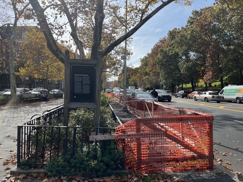
On Edgecombe Avenue at West 136th Street, on the left when traveling north on Edgecombe Avenue.
Dorrance Brooks (d. 1918) was an African American soldier who died in France shortly before the end of World War I. A native of Harlem and the son of a Civil War veteran, Brooks was a Private First Class in the 15th Infantry. In World War I, . . . — — Map (db m210008) HM
On St. Nicholas Avenue just north of West 117th Street, on the right when traveling south.
This site is a public garden which is maintained by neighborhood volunteers through GreenThumb. Founded in 1978, GreenThumb helps local residents transform vacant properties into attractive green spaces. If you want to join this garden, call (212) . . . — — Map (db m242841) HM
On West 135th Street at Lenox Terrace Place, on the right when traveling west on West 135th Street.
What was here before?
This property was part of farmer John Meyer's 108-acre estate. He purchased the property in 1825 and built his home at present-day Eighth Avenue and West 133rd Street in 1835, which remained until 1897. The property . . . — — Map (db m241557) HM
Near Bradhurst Avenue just north of West 145th Street, on the left when traveling north.
What was here before?
Before the pool and play center were introduced to the park, the rugged terrain of glacial rock outcroppings and mature shade trees served the Harlem Heights community as a place of respite and passive recreation. . . . — — Map (db m228707) HM
On Malcolm X Boulevard north of West 113th Street, on the right when traveling north.
Reverend Dr. Martin Luther King Jr. (1929-1968) was a pivotal figure in the civil rights movement of the 1950s and 1960s, famous for his fearless advocacy of nonviolent, direct action in the struggle against racism. King was a child prodigy who . . . — — Map (db m242843) HM
On West 114th Street east of Malcolm X Boulevard, on the left when traveling west.
Reverend Dr. Martin Luther King Jr. (1929-1968) was a pivotal figure in the civil rights movement of the 1950s and 1960s, famous for his fearless advocacy of nonviolent, direct action in the struggle against racism. King was a child prodigy who . . . — — Map (db m242845) HM
On Morningside Avenue west of East 114th Street, on the right when traveling south.
This striking bronze sculpture by Edgar Walter (1877-1938) is also known as Bear and Faun. It was dedicated in 1914 in memory of Alfred L. Seligman (1864-1910), vice-president of the National Highways Protective Association. Ironically, Mr. . . . — — Map (db m162526) HM
On Frederick Douglass Boulevard at West 122nd Street on Frederick Douglass Boulevard.
This larger-than-life bronze sculpture depicts abolitionist organizer and Underground Railroad leader Harriet Tubman (c. 1822-1913), and stands at the crossroads of St. Nicholas Avenue, West 122nd Street and Frederick Douglass Boulevard in Harlem. . . . — — Map (db m105284) HM
On 59th Street at Avenue of the Americas, on the right when traveling west on 59th Street.
One of a trio of bronze equestrian sculptures representing Latin American leaders, the Simon Bolivar statue commemorates a military general and advocate of Pan-Americanism. Bolivar (1783-1840) is credited with the liberation from Spanish . . . — — Map (db m42569) HM
On Park Road, 0.1 miles north of Grand Army Plaza, on the left when traveling north.
Central Park's zoo was almost not meant to be. The park's designers, Frederick Law Olmsted (1822-1903) and Calvert Vaux (1824-1895) excluded any zoo from their 1858 plan for Central Park. Yet, shortly after construction of the park began, a bear . . . — — Map (db m203804) HM
This striking gateway, designed by Edward Coe Embury (1906-1990) with sculpture by Paul Manship (1885-1966), was created as part of Central Park’s children’s zoo which opened in 1961. The zoo was first known as the Lehman Zoo for Children, as . . . — — Map (db m108320) HM
This statue of Scottish national poet Robert Burns (1759–1796), companion to the 1872 Sir Walter Scott (1771–1832) sculpture across Literary Walk, is by Sir John Steell (1804–1891), and was dedicated in 1880.
Burns was born . . . — — Map (db m108324) HM
On West Drive just north of East 65th Street, on the right when traveling north.
In 1979, the Sheep Meadow, like the rest of Central Park, was in a chronic state of decay following decades of neglect and mismanagement by a fiscally challenged New York City. After a year of restoration, the meadow was green and healthy, and as . . . — — Map (db m203796) HM
The historic Arsenal is one of two buildings in Central Park predating the park. It was designed by esteemed architect Martin T. Thompson (1786-1877) and built between 1847 and 1851 by the State of New York as a storage repository for the storage . . . — — Map (db m137070) HM
On 72nd Street Transverse Road at Central Park Driveway, on the left when traveling west on 72nd Street Transverse Road.
This elegant bronze statue by British Sculptor George Blackall Simonds (1843-1929) depicts a young falconer in Elizabethan garb holding aloft a falcon poised for release.
The Falconer is representative of the rich sculptural collection . . . — — Map (db m31059) HM
Near East Drive, 0.1 miles north of East 65th Street, on the right when traveling north.
The design that Frederick Law Olmsted and Calvert Vaux conceived for Central park transformed the rocky, marshy pre-park site into a masterful composition of diverse landscapes to create an idealized expression of rural scenery. These included . . . — — Map (db m203806) HM
On 9th Avenue near 28th Avenue, on the right when traveling south.
This monument consists of a 14-foot-tall
granite stele on which a bronze "doughboy"
soldier is displayed. He holds a rifle, has
a flag draped over his shoulders, and is
depicted as if in the midst of battle.
The derivation of the term . . . — — Map (db m173059) HM WM
On 10th Avenue at West 22nd Street, on the right when traveling north on 10th Avenue.
Scholar and poet Clement Clarke Moore (1779-1863) is the namesake
of two New York City parks. The
first is a playground in Elmhurst,
Queens, known as the Clement Clarke
Moore Homestead. The second is
this playground, located on a . . . — — Map (db m134956) HM
On West 16th Street west of 8th Avenue, on the left when traveling east.
Dr. Gertrude B. Kelly (1862-1934), a pioneer
surgeon and philanthropist, was born
in Ireland and emigrated to the United
States in 1873. She studied at the Women's
Medical College of the New York Infirmary
for Women and Children, which was . . . — — Map (db m126139) HM
On West 26th Street west of 8th Avenue, on the right when traveling east.
This playground, located on 26th Street
between 8th and 9th Avenues, takes
its name from Pennsylvania Station,
commonly known as Penn Station. The
original Penn Station was an above-ground
structure designed by the eminent New
York . . . — — Map (db m172964) HM
On Mulberry Street just south of Bayard Street, on the left when traveling north.
Dr. Sun Yat-sen was born in 1866 in China during the Qing Dynasty. His early education in China, Hawaii, and Hong Kong esablished him as a man of two worlds—China and the West—where he learned the essentials about democracy, which became his . . . — — Map (db m241563) HM
On Bayard Street west of Mulberry Street, on the right when traveling east.
Dr. Sun Yat-sen was born in 1866 in China during the Qing Dynasty. His early education in China, Hawaii, and Hong Kong esablished him as a man of two worlds—China and the West—where he learned the essentials about democracy, which became his . . . — — Map (db m241565) HM
On Worth Street at Mulberry Street, on the right when traveling west on Worth Street. Reported missing.
Columbus Park was named in 1911 after Christopher Columbus (1451-1506), the Italian explorer credited with discovering America, or at least with awakening Europe to the opportunities there. Bounded by Baxter (formerly Orange), Worth (formerly . . . — — Map (db m131756) HM
On Lafayette Street near Worth Street, on the left when traveling south. Reported permanently removed.
This impressive bronze statue, created by American sculptor George Edwin Bissell (1839-1920), depicts mayor Abraham De Peyster (1657-1728). Born in New Amsterdam (now known as “Manhattan”), De Peyster came from a prosperous mercantile family. In . . . — — Map (db m128530) HM
On Centre Street near Leonard Street, on the left when traveling north. Reported missing.
Located on Leonard Street between Centre and Lafayette Streets, this park occupies the eighteenth century site of Collect Pond. The pond was a large, 60-foot deep pool fed by an underground spring. The waters derived their name from seventeenth . . . — — Map (db m131757) HM
On Centre Street at Worth Street, on the right when traveling north on Centre Street. Reported permanently removed.
Foley Square is named for Thomas F. “Big Tom” Foley (1852-1925), a prominent Democratic Party leader from the Lower East Side of Manhattan. Foley left school at the age of thirteen to support his widowed mother, working for a period as . . . — — Map (db m41326) HM
“I only regret that I have but one life to lose for my country.” This graceful, 13-foot standing bronze figure, sculpted by Frederick MacMonnies (1863-1937), directly faces City Hall and honors the last moments of the . . . — — Map (db m130081) HM
On Park Row at Broadway, on the left when traveling south on Park Row. Reported missing.
This grove of flowering trees is a living memorial dedicated to the tragic events of September 11th, 2001. It is one of five Living Memorial Groves around the City, one in each borough in a park with clear views of downtown Manhattan where the twin . . . — — Map (db m130141) HM
On St. James Place near James Street, on the right when traveling north.
This park, located at the intersection of St. James Place, Oliver, Madison, and James Streets bordering the Civic Center, Chinatown, and Lower East Side neighborhoods of Manhattan, takes its name from nearby St. James Roman Catholic Church. The . . . — — Map (db m131955) HM
On Lafayette Street near Leonard Street, on the right when traveling south.
After Collect Pond was buried, various legends arose.
Legend 1: The pond supplied the city’s drinking water.
It did not. However, the city’s subterranean springs, which were the source of the pond’s water, fed two other water supply systems. . . . — — Map (db m131784) HM
On Centre Street near Worth Street, on the left when traveling north.
This park in the heart of New York City’s civic center is named for patriot, author, humanitarian, and political visionary Thomas Paine (1737-1809). The land that is now Thomas Paine Park was once part of a freshwater swamp surrounded, . . . — — Map (db m129041) HM
On East 128th Street at Lexington Avenue, on the left when traveling east on East 128th Street.
Alice Wragg Kornegay (1952 - 1996) was a pioneering community advocate in East Harlem for more than thirty five years. Born in Georgetown, South Carolina, she came to East Harlem to live with cousins at the age of ten, after her parents died. She . . . — — Map (db m183129) HM
On Lexington Avenue south of East 118th Street, on the right when traveling north.
This site is a public garden which is maintained by neighborhood volunteers through GreenThumb. Founded in 1978, GreenThumb helps local residents transform vacant properties into attractive green spaces. If you want to join this garden, call (212) . . . — — Map (db m241319) HM
On Pleasant Avenue just north of East 118th Street, on the left when traveling south.
This site is a public garden which is maintained by neighborhood volunteers through GreenThumb. Founded in 1978, GreenThumb helps local residents transform vacant properties into attractive green spaces. If you want to join this garden, call (212) . . . — — Map (db m242851) HM
On East 120th Street east of Lexington Avenue, on the left when traveling east.
Harlem Art Park is located at the corner of East 120th Street and Sylvan Place, a small road between Lexington and 3rd Avenues that was closed off for use as parkland. The City of New York originally acquired the first part of this property, a . . . — — Map (db m241321) HM
On Pleasant Avenue just south of East 119th Street, on the left when traveling south.
This garden takes its name from the Community of Pleasant Village, the area from 114th to 120th Streets on Pleasant Avenue and west to First Avenue. The neighborhood in turn takes its name from Pleasant Avenue, aptly dubbed for its idyllic . . . — — Map (db m242847) HM
On 1st Avenue at East 112th Street, on the right when traveling north on 1st Avenue.
What was here before?
This park in which this pool is located was planned and named by the Board of Aldermen in 1894, though the land for it was not purchased until 1897. The park opened on October 7, 1905 to provide organized play to the . . . — — Map (db m242852) HM
On East 106th Street west of 3rd Avenue, on the right when traveling east.
Bounded by Lexington Avenue, East 105th Street, and East 106th Street, this park honors renowned civil rights activist and author Walter White (1893-1955). White was born in Atlanta, Georgia, a few decades after the Civil War. Considering his . . . — — Map (db m242858) HM
On East 105th Street west of 3rd Avenue, on the right when traveling west.
What was here before?
The area, which became known as East Harlem, was rural for most of the 19th century. The construction of the elevated transit line to Harlem in 1879-1880, and the extension of the Interborough Rapid Transit line in . . . — — Map (db m242861) HM
On West 108th Street west of Columbus Avenue, on the left when traveling east.
This playground honors the memory of Anibal Aviles (1947-1966), a gifted athlete who attended nearby J.H.S. 54, where he captained both the basketball and track teams. Raised on West 109th Street, Aviles belonged to a local Catholic Youth . . . — — Map (db m242813) HM
On Amsterdam Avenue north of West 104th Street, on the right when traveling north.
Formerly known as P.S. 145 Playground, this parkland was renamed in 1997 to reflect the rich history of the area. The Upper West Side was named Bloomingdale by 17th century Dutch and Fleming settlers after a town near Haarlem in the Netherlands. . . . — — Map (db m242787) HM
On Amsterdam Avenue at West 101st Street, on the right when traveling north on Amsterdam Avenue.
This playground is named for Frederick Douglass (1818-1895), celebrated African American abolitionist, orator, author, and statesman. Frederick Douglass Playground is located on Amsterdam Avenue between 100th and 102nd Streets. In 1954, the City . . . — — Map (db m242778) HM
On Amsterdam Avenue south of West 99th Street, on the right when traveling north.
Located at West 96th Street and Amsterdam Avenue, this playground and the adjoining school honor four-term New York Governor Alfred Emanuel Smith (1873-1944). The son of Irish immigrants, Smith dropped out of school to help support his family. . . . — — Map (db m242774) HM
On Morningside Avenue south of West 123rd Street, on the right when traveling south.
What was here before?
This area of Morningside Heights was formerly known as Muscoota ("flat place" or "plain") to the Lenape in the Harlem Plain, Vrendendal ("Peaceful Dale") to 17th century Dutch settlers, and Vandewater . . . — — Map (db m241517) HM
On Morningside Avenue just north of West 114th Street, on the right when traveling south.
What was here before?
This area of Morningside Heights was formerly known as Muscoota ("flat place" or "plain") to the Lenape in the Harlem Plain, Vrendendal ("Peaceful Dale") to 17th century Dutch settlers, and Vandewater . . . — — Map (db m242834) HM
On Catherine Street just south of Monroe Street, on the right when traveling south.
This park honors Governor Alfred Emanuel Smith (1873-1944), who rose from the Lower East Side as the son of Irish immigrants to become a New York State and City legislator, governor, and the first Catholic candidate for President of the United . . . — — Map (db m241574) HM
On Cherry Street at Catherine Slip, on the right when traveling east on Cherry Street.
On this site in 1786, Henry Rutgers (1745-1830) built the Catherine Market which was named for his mother Catherine Rutgers (1711-1799). The market, whose vendors sold meats and fish, was near to the Catherine ferry and was popular among the . . . — — Map (db m241577) HM
Alfred E. Smith (1873-1944) served as Governor of New York from 1919 to 1920 and from 1923 to 1928.
He was the Democratic presidential candidate in 1928. As a result of his dedication to housing and social issues, Al Smith led the state’s . . . — — Map (db m132067) HM
Near Union Square W near E 17th Street, on the left when traveling south. Reported permanently removed.
One of three sculptural renditions of Abraham Lincoln (1809-1865) in New York City’s parks, this larger-than-life bronze by Henry Kirke Brown (1814-1886) stands vigil on a busy crossroads at the north end of Union Square Park. Abraham Lincoln was . . . — — Map (db m41271) HM
On Union Square West at East 16th Street, on the right when traveling north on Union Square West.
One of three sculptural renditions of Abraham Lincoln (1809-1865) in New York City's parks, this bronze larger-than-life sized statue by Henry Kirke Brown (1814-1886) today stands vigil on a busy crossroad at the north side of Union Square Park. . . . — — Map (db m242889) HM
On East 14th Street east of Union Square East, on the right when traveling west. Reported permanently removed.
This impressive bronze equestrian portrait of George Washington (1732-1799), the first president of the United States, is the oldest sculpture in the New York City Parks collection. It was modeled by Henry Kirka Brown (1814-1886) and dedicated in . . . — — Map (db m242871) HM
On East 14th Street near between Union Square East & West, on the right when traveling south. Reported permanently removed.
This impressive bronze equestrian portrait of George Washington (1732-1799), the first President of the United States, is the oldest sculpture in the New York City parks collection. It was modeled by Henry Kirke Brown (1814-1886) and dedicated in . . . — — Map (db m138392) HM
Near Edgecombe Avenue south of West 158th Street, on the right when traveling north.
Dedicated to John T. Brush (1845-1912), the long-time owner of the New York Giants baseball franchise, this steel-and-concrete stairway with 80 steps was presented to the City of New York by the New York Giants on July 9, 1913. Brush previously . . . — — Map (db m242815) HM
On Morningside Avenue at Dr. Martin Luther King Jr. Boulevard, on the right when traveling south on Morningside Avenue.
Acquired and dedicated in 1941, this park is named for Franklin Delano Roosevelt (1882-1945), the 32nd President of the United States, who led the country through the Great Depression and World War II. Like his distant cousin Theodore Roosevelt . . . — — Map (db m241510) HM
On 19th Street south of 23rd Drive, on the right when traveling south.
What was here before?
At one time local children swam in the Hell Gate tidal strait at the base the natural hillside embankment in the turbulent waters. The endangerment to citizens in Astoria and to coastal waters throughout the city led . . . — — Map (db m241590) HM
Near Shore Boulevard south of Ditmars Boulevard, on the left when traveling south.
The pin oak and serviceberry trees planted in this grove are a living memorial to the fathers and mothers, sisters and brothers, sons and daughters, family and friends lost to us far to soon, on Flight 587. May their spirit live on in the beauty . . . — — Map (db m241386) HM
On Shore Boulevard, 0.4 miles south of Ditmars Boulevard, on the right when traveling south.
On the morning of June 15, 1904, the steamboat General Slocum caught fire in the East River with approximately 1,300 people on board, including many children. In the course of 20 minutes an estimated 1,021 people died. Prior to September 11, . . . — — Map (db m241295) HM
On Totten Avenue, on the right when traveling north.
History
This park takes its name from the Civil War era fortress on the property. Originally referred to by its location on Willets Point, the Army officially named it for General Joseph Totten (1788-1864), following his demise in the Battle of . . . — — Map (db m65126) HM
King Hussain of the Hachamite Kingdom of Jordan presented this 30 foot-high marble column to the New York World’s Fair Corporation and City of New York on the occasion of Jordan’s participation in the New York World’s Fair of 1964-65, held in . . . — — Map (db m108561) HM
On 111th Street at United Nations Avenue North, on the right when traveling north on 111th Street.
Flushing Meadows-Corona Park, today New York City's second largest park, has risen like a phoenix from the ashes. The 1,255-acre open space was indeed an ash disposal heap in the early 20th Century, noted by F. Scott Fitzgerald in The Great . . . — — Map (db m239583) HM
On Zoo Path at Zoo Bridge, on the right when traveling north on Zoo Path. Reported unreadable.
The animal motifs for these fanciful bronze grillwork gates were designed by architects Clarke and Rapuana, and dating to 1960, were crafted by the Italian-born sculptor Albino Manca (1898-1976).
Following the New York World's Fair of . . . — — Map (db m193539) HM
On Avenue of the Americas south of United Nations Avenue North, on the left when traveling north.
The Unisphere, located at the center of the radial pathways in the northern half of Flushing Meadows Corona Park, was commissioned for the New York World's Fair of 1964-65. Designed by landscape architect Gilmore D. Clarke (1892-1982) in aluminum . . . — — Map (db m239575) HM
On 29th Street south of 39th Avenue, on the left when traveling north.
This site is a public garden which is maintained by neighborhood volunteers through GreenThumb. Founded in 1978, GreenThumb helps local residents transform vacant properties into attractive green spaces. If you want to join this garden, call (212) . . . — — Map (db m239598) HM
On Main Street just south of Elder Avenue, on the left when traveling north.
Flushing Meadows-Corona Park, today New York City's second largest park, has risen like a phoenix from the ashes. The 1,255-acre open space was indeed an ash disposal heap in the early 20th Century, noted by F. Scott Fitzgerald in The Great . . . — — Map (db m228659) HM
On 37th Avenue, 0.1 miles west of Parsons Boulevard, on the right when traveling west.
About the Homestead
The Homestead was built between 1774 and 1785. Captain Joseph King first purchased this farmhouse from his father-in-law in 1801 and named it "Kingsland." His family and their descendants lived here until the 1930s. . . . — — Map (db m193349) HM
On Leavitt Street just north of 137th Street, on the left when traveling north.
About the House
Lewis Howard Latimer [1848-1928] was an African American inventor, son of fugitive slaves, self-taught poet, and painter. His historic Victorian home in Flushing, Queens, is now a New York City Landmark and museum, operated . . . — — Map (db m193420) HM
On Shore Road at Ordinance Road, on the right when traveling north on Shore Road.
History This park takes its name from the Civil War era fortress on the property. Originally referred to by its location on Willets Point, the Army officially named it for General Joseph Totten (1788-1864), following his demise in the . . . — — Map (db m65125) HM
Near Totten Road west of Ordinance Road, on the left when traveling west.
Within the northeast corner of the Fort Totten Water Battery lies the “Main Magazine”. The Main Magazine consists of three vaulted rooms. The two larger rooms, numbers two and three, were used to store gun powder, while room number one was used to . . . — — Map (db m65129) HM
On Jamaica Avenue at 150th Street, on the left when traveling east on Jamaica Avenue.
About the Manor
This 18th-19th century manor was home to Rufus King, signer of the U.S. Constitution and early voice in the anti-slavery movement. His son, John A. King, Governor of New York State from 1857-1859, resided here later. More than . . . — — Map (db m239545) HM
Near Center Avenue at 51st Avenue, on the left when traveling north.
Before the 1870s, Hunter's Point was a tidal wetland with meadows, sandy hills, rock outcroppings, marshes, and streams. Much of southern Hunter's Point, including this park, was under water.
Before the arrival of Europeans in the 17th . . . — — Map (db m241583) HM
Near 57th Avenue at Center Boulevard, on the left when traveling north.
Salt marshes play a vital role in our coastal waters. These ecosystems protect the shoreline from erosion, filter pollutants from the water, and provide a rich wildlife habitat.
In the last 200 years, more than 80 percent of New York City's . . . — — Map (db m241581) HM
On 45th Road east of 11th Street, on the left when traveling east.
This park is named for John F. Murray (1889-1944), a lifetime Queens resident and a dedicated recreation supervisor for Queens parks for many years. Although his Parks job kept him busy, he also devoted much of his time to a variety of other . . . — — Map (db m203810) HM
Near 2nd Street east of 57th Avenue, on the left when traveling west.
This section of the park is the former site of the New York Sugar Refining Company of Long Island City.
Claus Doscher, a Brooklyn sugar refiner, founded the New York Sugar Refining Company of Long Island City in 1897. Located on Second . . . — — Map (db m241582) HM
On 41st Avenue at Queens Plaza North, on the left when traveling west on 41st Avenue.
These two 19th-century millstones were removed from the sidewalk during the 2011 reconstruction of Queens Plaza and set within this landscape as a reminder of Queens' agrarian past. Millstones like these were used to grind corn and grain into . . . — — Map (db m241367) HM
On Atlantic Avenue west of 106th Street, on the right when traveling east.
This playground is named in honor of dedicated politician and public servant Maurice A. FitzGerald (1897-1951). FitzGerald was born in Brooklyn and attended Boys’ High School and the New Lots Evening High School. He began his career as a civil . . . — — Map (db m133888) HM
On Greenpoint Avenue just west of 43rd Street, on the right when traveling west.
What was here before?
This playground is located in the Sunnyside section of Queens whose name originates from the Bragaw family estate, Sunnyside Hill, built in 1713. This area was a rural hamlet mostly consisting of small farms and . . . — — Map (db m210054) HM
Near 47th Avenue west of 43rd Street, on the left when traveling west.
What was here before?
This playground is located in the Sunnyside section of Queens whose name originates from the Bragaw family estate, Sunnyside Hill, built in 1713. This area was a rural hamlet mostly consisting of small farms and . . . — — Map (db m210055) HM
On Chapin Avenue at Salzburg Court, on the left when traveling north on Chapin Avenue.
This pond is named after Jerome X. O’Donovan (1944 – 2014), more commonly known as “Jay” O’Donovan, a lifelong Staten Island resident and decorated Marine Corps Veteran who earned two bronze stars and a promotion to Captain during the Vietnam . . . — — Map (db m160769) HM
On School Road at Bay Street when traveling north on School Road.
This park on the northeastern shore of Staten Island occupies the site of the former estate of Arthur Von Briesen (1843-1920).
A native of Germany, Von Briesen immigrated to the United States in 1858 at the age of 15. After enduring some . . . — — Map (db m154037) HM
Near Tennyson Drive at Nelson Avenue, on the right when traveling north.
What was here before?
The region's earliest inhabitants were the Lenape. After Frenchman Jacques Guyon (1637-1688) settled here in 1664, this area was populated by Europeans by the end of that century.
Originally called "Gifford" after . . . — — Map (db m239519) HM
On New Dorp Lane at Cedar Grove Avenue, on the right when traveling east on New Dorp Lane.
This park commemorates Staten Island resident Corporal Allan Francis Kivlehan (1932-1950), who was raised in the local New Dorp Beach neighborhood and died at the age of eighteen, while serving this country in the Korean War.
Kivlehan grew . . . — — Map (db m181556) HM WM
Near Richmond Terrace, on the right when traveling west. Reported permanently removed.
Faber Park and Pool is located on what was once the north shore home of the Faber family. Their lead pencil manufacturing company was begun by Caspar Faber in Stein, Germany in 1761. A century later, his descendant Eberhard Faber (d.1879) came to . . . — — Map (db m42655) HM
On Richmond Terrace just west of Faber Street, on the right when traveling west.
What was here before?
Faber Park and Pool is located on what was once the Faber family's North Shore property. Jenny Faber, a family member living in Port Richmond, was granted a deed in 1869 to the surrounding land under and above the Kill . . . — — Map (db m181576) HM
Near Chester Avenue west of Cornelia Avenue, on the left when traveling west. Reported permanently removed.
[Much of the marker was illegible at the time the photo was taken.]
Conclusion
The Ardennes Campaign was crucial to ending the war in Europe. American and Allied Forces had met and defeated an exceptionally large number of the . . . — — Map (db m239515) HM
Near Seguine Avenue east of Hank Place, on the right when traveling east. Reported permanently removed.
A stately Greek Revival structure, the Seguine House faces Prince’s Bay on the southern shore of Staten Island. Built in 1838 by Joseph H. Seguine (1801-1856), the house is a physical reminder of the classical architecture and thriving commerce of . . . — — Map (db m155032) HM
On Seguine Avenue just south of Hank Place, on the right when traveling south. Reported damaged.
Built in 1838, this Greek Revival-style house is one of the grandest 19th century homes on Staten Island. It is listed on the National Register of Historic Places and is a proud New York City and State Landmark. — — Map (db m181545) HM
At dawn on Dec. 16, 1944, three powerful German armies plunged headlong into the rugged hills and dense forests of the Ardennes region of Belgium and Luxembourg. Sheltered from Allied air attacks by dense fog and bad weather, they attacked the . . . — — Map (db m154945) HM
On Hylan Boulevard just south of Edgewater Street, on the right when traveling north.
About the House
The original Dutch farmhouse, built in 1690, was purchased in 1844 by Alice Austen's (1866-1952) grandfather, John Haggerty Austen. Austen's architectural transformation of his home into a Victorian Gothic cottage was . . . — — Map (db m207457) HM
On Tompkins Avenue south of Chestnut Avenue, on the left when traveling south.
Nicholas De Matti Playground is one of nine playgrounds that Parks built through a war memorial fund. They opened simultaneously on July 15, 1934. Nicholas De Matti was a Private, First Class, in Company K, 310th Infantry, 78th Division, and a . . . — — Map (db m158616) HM WM
On Louis Street just west of Howard Avenue, on the right when traveling east.
Bounded by Victory Boulevard, Louis Street, and Howard Avenue, Hero Park honors the 144 Staten Island soldiers who died in World War I. Large evergreen trees, dedicated to each veteran decorate the park. Plaques with each soldier's name once . . . — — Map (db m239458) HM
On Louis Street just west of Howard Avenue, on the right when traveling east.
What was here before?
This area was once home to the Lenape. The landscape remained rural until the mid-19th century. As more people moved from more crowded parts of New York City, towns were incorporated to accommodate the increase in . . . — — Map (db m239455) HM
On Tompkins Avenue, 0.1 miles south of Tompkins Street, on the right when traveling south.
What was here before?
Stapleton was founded in 1836, and by the 1860s was home to a large German immigrant community who recognized the area's beer brewing potential and its many fresh springs and hillsides for underground cool storage . . . — — Map (db m239474) HM
On Water Street at Canal Street, on the left when traveling west on Water Street. Reported damaged.
The neighborhood of Stapleton, founded in 1836, was named for William J. Staples (1807-1883), who along with his partner Minthorn Thompkins (1807-1881), purchased the land in the northeast corner of Staten Island from the Vanderbilt family. They . . . — — Map (db m207534) HM
On Water Street at Navy Pier Court, on the right when traveling north on Water Street.
Opened in 2016, Stapleton Waterfront Park connects Stapleton and surrounding neighborhoods with new access to the waterfront. The neighborhood of Stapleton was founded in 1836 and named for William J. Staples (1807-1883). Along with Minthorn . . . — — Map (db m207489) HM
On Page Avenue at Bartow Avenue, on the right when traveling north on Page Avenue.
Aesop (c. 620 - 564 BC) is famous for his fables, metaphorical fairy tales with moral conclusions. According to Greek tradition, Aesop was born into slavery in approximately 620 BC in the ancient Greek town of Mesembria in the region of Thrace. . . . — — Map (db m208938) HM
On Satterlee Street north of Hylan Blvd., on the left when traveling north.
Christopher Billop’s c. 1680 grand stone manor is named in memory of the 1776 conference convened at the House in an attempt to end the Revolutionary War. It is a National Historic Landmark listed on the National Register of Historic Places and is . . . — — Map (db m42669) HM