On Transcontinental Railroad Back Country Byway, on the left.
Mile 746.6 from San Francisco
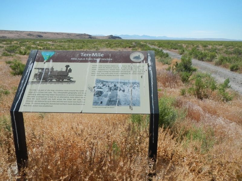
Ten-Mile was part of the long, circuitous route around the northern edge of the Great Salt Lake. Dry, inhospitable geography and steep railroad grades requiring helper locomotives in several locations led the . . . — — Map (db m105304) HM
On S 100 W at South Street, on the right when traveling north on S 100 W.
Settled March 31, 1851 by five families followed by six families in the fall. It was first called North Willow Creek and changed to Willard in 1857. The fort was built in 1853 to 1855, constructed of dirt and rock. The first grist mill was begun . . . — — Map (db m240488) HM
Near Willard Peak Road (Forest Road 84), on the right when traveling south.
Land abuse and uncontrolled fire in this basin brought about serious floods. In 1923 and 1936 two lives were lost, homes and valuable farmland were damaged. These lands were left barren and gullied.
Recognizing the need to restore this . . . — — Map (db m136327) HM
When the Willard Central School was constructed in 1902, a bell tower with a large brass bell was installed on the roof toward the front of the building. The bell was rung fifteen minutes before school began and again at noon. Students vied for . . . — — Map (db m240487) HM
On North Main Street at W 300 N, on the right when traveling north on North Main Street.
The Willard Pioneer Cemetery's first burial was August 1854 with the death of five-day-old John Memorial, Jr., son of John Memorial (Memory) and Samantha Wells
McCrary. This site, selected by Willard's first settlers, is located one block east . . . — — Map (db m240482) HM
On Center Street at 200 West, on the left when traveling east on Center Street.
Erected in honor of those pioneers who helped settle Hyde Park. This Settlement was founded in 1860 by the following list.
William Hyde, William Higgensen, Robert Daines, Lydia Wilkinson, Anthony Metcalf, James Hancey, Armenius Neeley, Thomas . . . — — Map (db m44498) HM
On West Main Street (Utah Route 101) just east of North 100 West, on the right when traveling west.
The Elite Hall dance hall, designed by architect K.C. Schaub and constructed in 1917, is significant for its association with community events in the city of Hyrum. Financed by the Hyrum Amusement Company, Elite Hall became the primary dancing and . . . — — Map (db m149592) HM
On West Main Street (Utah Route 101) west of South Center Street, on the left when traveling west.
To commemorate an important episode in the early history of the west and to honor the scouts and explorers of earlier days, this monument was erected. In this vicinity in the winter of 1825-26 a cache containing 75 bales of furs, mostly beaver, . . . — — Map (db m149775) HM
On North Main Street (U.S. 91) at East 100 North, on the right when traveling north on North Main Street.
This structure is built with beautiful, gray brick that has been well preserved. The two-story flat roofed building has a classical emphasis. The original front entrance of double doors was crowned with a stone engraving depicting a pioneer scene . . . — — Map (db m44420) HM
This building, constructed in 1904, was first occupied by John H. Anderson who operated a general merchandise store. The store continued to function until the mid - 1960’s and sold shoes, dry goods, groceries, and clothing. The original owner, Louie . . . — — Map (db m44448) HM
On Main Street, on the right when traveling north.
This large brick structure, built in 1911, is classical in style and virtually unaltered since construction. The top of the building is crowned by a heavy, classic cornice. The front entrance is sided by pilasters and topped with a modified Roman . . . — — Map (db m44429) HM
On N. Main Street at W. Center St., on the left when traveling north on N. Main Street.
Built c. 1890, this two-story, dark brick structure is crowned with a cream colored Federal-Greek cornice. Below the cornice are three French doors with transoms and small, Latin balconies. Large transom windows at the mezzanine have segmented . . . — — Map (db m44424) HM
On West Center Street west of South 200 West, on the left when traveling west.
Constructed in 1921, this two-story home is an excellent example of the Prairie School style popular between 1901 and 1925. The early of Frank Lloyd Wright gave rise to the Prairie School style by creating forms that were precise and angular with an . . . — — Map (db m44421) HM
On Main Street at Center Street, on the left when traveling north on Main Street.
Wells Fargo Bank now occupies the site of the Thatcher Brothers Bank & Opera House, which was constructed in 1890. The Thatcher Brothers Bank was the first one to open in the valley. The Opera House was located on the second floor and could seat 800 . . . — — Map (db m44426) HM
This property was owned in the late 1800’s and early 1900’s by Luna Young Thatcher, a daughter of Brigham Young by his first wife. Luna Young Thatcher owned the entire corner and, by all reports, had the area beautifully landscaped. In 1912 the . . . — — Map (db m44447) HM
On Main Street at 100 North, on the right when traveling south on Main Street.
This building was one of the earliest general merchandise stores built in Logan, and it continued as such until 1872. The owner sold the building and his merchandise and joined the historically significant ‘cooperative’ movement sponsored by the . . . — — Map (db m44481) HM
This large, two-story, brick building is one of Logan’s early examples of commercial architecture, with some Victorian embellishments added. The building was constructed in 1902 by George W. Thatcher. KVNU, the first radio station in Logan, got it’s . . . — — Map (db m45819) HM
Restored in honor of pioneer Logan residents David Eccles 1849-1912 Ellen Stoddard Eccles 1867-1957
David Eccles, a Scottish immigrant to Utah became one of the state’s most prominent business leaders. His extensive enterprises laid the . . . — — Map (db m44432) HM
Erected in 1861 by Hezekiah Thatcher, assisted by Robert Crookston, Robert Murdock and John Hill, who quarried the building stones in Green Canyon and place them in these walls, hand made shingles covered the roof, the building was originally used . . . — — Map (db m44436) HM
Known to the Indians as Willow Valley was renamed by fur trappers and traders in the winter of 1825-1826. James Bridger led the first trappers to a winter encampment near here in 1824 towards December 1825. William L. Sublette, in charge of Gen . . . — — Map (db m44438) HM
First used as theatre in 1913.
Original Owner: George W. Thatcher and B.G. Thatcher
Renovation made possible by Utah State University, Thatcher families and community of Logan. — — Map (db m44441) HM
Built 1907 of brick and white stone trim for David and Ellen Stoddard Eccles. Architects: Monson & Schaub of Logan. Renovation 1972 by S. Eugene Needham and Christie Smith Needham. — — Map (db m44442) HM
Colonel Russell L Maughan of Logan, Utah, made the first daylight flight across the continent on June 23, 1924. Flying solo in a Curtis PW-8 pursuit aircraft, Maughan, then a Lieutenant in the U.S. Air Service, left Mitchell Field, New York, at dawn . . . — — Map (db m44451) HM
This house was built in 1890 for John R. and Bartha Blanchard. In 1903, this building was converted into the first hospital in the Cache Valley with a capacity of seven beds in four rooms. In 1916, it was sold to the Presbyterian Church and used . . . — — Map (db m44446) HM
On W. Center Street at S 300W on W. Center Street.
Built in 1914 - 15 by Charles W. Nibley for his third wife, Julia Budge, this two story house is an excellent example of the Prairie School style popular in Utah during 1905-25. The house was reportedly designed by Pope and Burton, architects. C.W. . . . — — Map (db m44427) HM
Thirty feet east of this spot was built, in the winter of 1865-1866, under the leadership of Benget P. Woolfenstein, the first community center of the Logan Fifth Ward. Consisting of but one room, 16 by 20 feet. It served, nevertheless, as church . . . — — Map (db m154443) HM
On East 1000 North, on the left when traveling east.
Utah State University’s football field at Romney Stadium as named the Merlin Olsen Field at Romney Stadium on December 5, 2009 by President Stan L. Albrecht.
The statue was unveiled on October 23, 2010. In attendance were many of Merlin and . . . — — Map (db m44455) HM
In 1860 two grist mills were built and operated in this valley. One at Wellsville by Daniel P. Hill and the other at Millville by Esias Edwards and Leroy Kent. The first burrstones obtained from Black Rock, Utah proved to be too soft for grinding so . . . — — Map (db m44471) HM
On 100 North at 100 East, on the left when traveling east on 100 North.
Seat of the first Non-Mormon congregation in Cache Valley, 1873. Gothic church and vicarage consecrated 1909. Logan’s first public Library and the Common Room Club housed in the vicarage. — — Map (db m44443) HM
The Thatcher - Young Mansion was built in 1878 for the banker and industrialist George W. Thatcher and his wife Eunice Caroline (Luna) Young Thatcher. Her brother Brigham Young Jr. lived in it from 1883 - 1885 while he supervised the Brigham Young . . . — — Map (db m44440) HM
The first settlers of Logan encamped near this spot on the bank of the Little Logan early in May 1859
Heads of Families: John R Blanchard, Abraham Caldwell, Griffith Charles, Israel J. Clark, Ann Davis, William Dees, James Demino, Sidney Dibble, . . . — — Map (db m44437) HM
On North 400 East at East 300 North, on the right when traveling north on North 400 East.
The Whittier School, constructed in 1908, is important for its association with the education reform following Utah’s statehood. These reforms included a statewide curriculum and the construction of numerous unified schoolhouses. The Whittier School . . . — — Map (db m108847) HM
On North 100 West (Utah Route 23) at West 100 North, on the right when traveling south on North 100 West.
Originally built around 1865, the 1½ story rock home of James G. Willie is typical of the over 40 stone homes that were built in Mendon prior to 1880. Brigham Young encouraged early settlers to use native rocks for home construction as he felt . . . — — Map (db m44482) HM
On 206 W 100 S at 100 S, on the right when traveling east on 206 W 100 S.
In the spring of 1860, Apostle Ezra T. Benson and Peter Maughan advised the people living at the Elkhorn Ranch to locate near a sawmill built by Esais Edwards and Roy Kent. This was done to provide better protection. In that same year, Apostle . . . — — Map (db m44456) HM
On West 3200 South west of South 600 West, on the right when traveling west.
In July, 1855, the first settlers in Cache Valley, 23 men and 2 women under the leadership of Martin Ensign and Bryant Stringham came to Willow Valley with about 2000 cattle, established Elk Horn Ranch near some fine springs, located about one mile . . . — — Map (db m149769) HM
On 1494 E 2300 N, on the right when traveling east.
Built 1890 - 1900 of logs hauled from Logan Canyon by Nicholas W. Crookston, Sheriff, Bishop, and construction foreman. Registered by Lucille C. Peterson 11-1-72 — — Map (db m44462) HM
This marker honors the first settlers of Providence, who camped near here early in May 1859, and those who followed in the years 1860,1861,1862. Included in the groups who pioneered this section are the following families: Alder, Bowen, . . . — — Map (db m44477) HM
On 10 S Main St. at Center St., on the left when traveling south on 10 S Main St..
Symbol of Heritage
Listed on the National Register of Historical Places in recognition of its architectural and historical significance, and to encourage its preservation.
The 1869 completion of the transcontinental railroad ended an era, that . . . — — Map (db m46302) HM
On Main Street at Center Street, on the right when traveling south on Main Street.
Pioneer dramatic players entertained early Cache Valley audiences in this rock building. When erected, 1868 - 70, the only assembly hall in Providence. It has the finest dance floor, stage, proscenium, paintings, curtain in the valley. Among the . . . — — Map (db m44435) HM
On South 200 West (U.S. 91 at milepost 40) near West Main Street, on the right when traveling north.
In July 1859 under the leadership of John Bair, (interpreter and guide) sixteen families settled here, built log cabins and dugouts between City Creek and Brower Springs. The following Spring other families arrived and a permanent fort was built for . . . — — Map (db m105497) HM
The house was designed by Gottlieb Stucki of Logan City in 1936 and is one on only two international Style houses built in Richmond. The Webb family was active in the Richmond community during the mid-century. Mr Webb was postmaster for 37 years . . . — — Map (db m44459) HM
First person buried in the Smithfield Cemetery, was born at Alder, Erie County, New York, in 1835, the son of Austin and Laura Wilder Harris Merrill, He was killed in an Indian attack July 29, 1880 as he and his brother Solyman were returning from . . . — — Map (db m44449) HM
On U.S. 6 at Utah Route 123, on the right when traveling north on U.S. 6.
Rock asphalt was first mined at the top of Whitmore Canyon - 15 mi. NE of this location - in the early 1890's. The mine closed in 1898 & re-opened in 1903. It operated erratically until 1915 when it was forced to close due to the development of . . . — — Map (db m148003) HM
On U.S. 6 at Utah Route 123, on the right when traveling north on U.S. 6.
Early settlers in Whitmore Canyon, later called Sunnyside, were Jefferson Tidwell, his family and a brother John, who grazed cattle in the area prior to building their home in 1897. They located a vein of coal, sold it to the Utah Fuel Company for . . . — — Map (db m148001) HM
On South Main Street, on the right when traveling north.
This one-story red brick commercial building was built in 1927 by Helper Securities.
Five business storefronts completed the whole of this larger building. The northernmost portion at 167 South Main Street was occupied by the Success Meat and . . . — — Map (db m148211) HM
On South Main Street, on the right when traveling south.
This single-story, red brick, commercial one-part block building was originally owned by John Milon, George Gigoumakis, and Steve Zoulakis. The building was at one time an O.P. Skaggs meat and grocery store operated by Barney Hyde. Mr. Hyde was also . . . — — Map (db m148217) HM
On U.S. 191 at milepost 259.2, on the left when traveling north.
Erected in 1918, by inmates of The Utah State Penitentiary. This monument honors Simon Bamberger, Governor of Utah from 1917 through 1920. Under a state law passed in 1911 permitting prisoners to work on State roads, the prisoners participated in . . . — — Map (db m148288) HM
The Carbon Hotel was built in the early 1900's. It was first owned by C.A. Bartolino. The building was used as a hotel, bar, cafe and sporting house throughout the years. Due to the large number of single male immigrants into the local mines, the . . . — — Map (db m100991) HM
On U.S. 6, 0.5 miles north of U.S. 191, on the right when traveling north.
This monument is dedicated to the Carbon Plant, located SE of this site, the fourth coal-fired facility built by Utah Power. Construction on the $26 million plant began the summer of 1953, in cooperation with the International Brotherhood of . . . — — Map (db m148289) HM
On U.S. 6, 0.5 miles north of U.S. 191, on the right when traveling north.
At 8:30 a.m., March 8, 1924, an explosion occurred in the Castle Gate No. 2 Mine, located about one half mile to the southeast of this site, instantly killing 171 miners. Rescue teams were rushed to Castle Gate from the surrounding mines. Wearing . . . — — Map (db m148291) HM
On South Main Street, on the left when traveling north.
Utah Railway was created in 1912 to provide improved service to the coal mines of western Carbon and Emery counties. Tracks from Hiawatha to the Utah Railway junction near Martin were completed in Oct. 1914. A steel girder bridge 135 ft. high, 634 . . . — — Map (db m148206) HM
On South Main Street, on the right when traveling north.
This valley was originally settled in 1881 by Teancum Pratt. The original Pratt Survey still predominates on maps of this area. He sold land to the Rio Grande Western Railroad for a right of way. By the fall of 1887 the railroad had built 27 frame . . . — — Map (db m148214) HM
On South Main Street, on the right when traveling north.
This one-story red brick flat roof building was built as the Helper City Hall in 1927. This building has classical "tin" cornices, columns and pediment. The project architect was Walter E. Ware of Salt Lake City.
The City Hall has been a center . . . — — Map (db m148212) HM
On South Main Street, on the right when traveling north.
Built in 1937, the Helper Civic Auditorium was designed by Salt Lake City architects Carl W. Scott and George W. Welch. The building is an excellent example of Art Moderne style also known as "Streamline Moderne." The style was popular in the 1930s . . . — — Map (db m148221) HM
On South Main Street at Poplar Street, on the left when traveling north on South Main Street.
This hotel was built in 1913-14 for the Helper Real Estate and Investment Co. Formed by people of many different ethnic groups, including Assyrian, Italian, and Jewish, this company reflected the diverse nature of Helper's population. A favorite of . . . — — Map (db m148122) HM
On South Main Street, on the right when traveling north.
The Helper Main Post Office, built in 1937 by the Works Progress Administration (WPA), is significant for its association with the federal government's New Deal public arts programs. As one of only three Utah post offices that contain public art, it . . . — — Map (db m148220) HM
Matt Warner was born Willard E. Christiansen in Ephraim, Utah. He left home at the age of 14 after a fight in which he thought he killed the town bully. He took the name Matt Warner, became a cattle rustler, bank robber and rode with Butch Cassidy . . . — — Map (db m101029) HM
On U.S. 6, 0.6 miles north of U.S. 191, on the right when traveling north.
Near this site stood the Pleasant Valley Coal Company office and store.
On April 21, 1897, in of of the most daring daylight robberies, Butch Cassidy, Elsa Lay, and Bob Meeks robbed paymaster E.L. Carpenter and made off with over $8000.00 in . . . — — Map (db m148293) HM
On U.S. 6 at milepost 217.5, on the right when traveling west.
Pleasant Valley Junction about 1/2 mile So. of this site, began in the early 1880's when the Rio Grande R.R. extended the main line from Tucker over the summit into Carbon County. A round house was built and a branch line extended to the Pleasant . . . — — Map (db m148616) HM
On North Main Street, on the left when traveling west.
The Rainbow Inn is located at 305 N Mains St, Helper, Utah and was built in 1922. Originally owned by Lena Fodero, the building was used as a hotel, bar, and sporting house. It was known for the bordello on the upper floor. The railroad which . . . — — Map (db m106558) HM
On South Main Street, on the right when traveling north.
This two-story brick commercial building was constructed in 1929. The varied shades of tan bricks are unusual in the historic district. In the early 1930s, the right side of the building was occupied by the "Smart Shop" owned by N.A. Neilson, and . . . — — Map (db m148208) HM
On South Main Street, on the left when traveling north.
The Barboglio Building was built in 1907 by Joe Barboglio. The building housed the Tika Tavern with a hotel upstairs. Mrs. Barboglio ran the hotel and washed the linen by hand in the Price River. In 1910, in an effort to help other businessmen, the . . . — — Map (db m148209) HM
On South Main Street, on the left when traveling north.
Around 1891 after the D & R G W Railroad replaced the narrow gauge, with standard gauge track, the division point was consolidated in Helper. At this time a 15 stall roundhouse, a new depot and other accommodations were built. In 1919 the division . . . — — Map (db m148207) HM
On U.S. 6, 0.5 miles north of U.S. 191, on the right when traveling north.
The name Carbon County appropriately suggests the importance of carbon products to the economy and history of this area.
The first commercial development of coal occurred in this vicinity in the 1870's and soon out distanced production in other . . . — — Map (db m148292) HM
On U.S. 6, 0.5 miles north of U.S. 191, on the right when traveling north.
On July 31, 2000, at approximately 11:48 p.m. an explosion and fire rocked the Willow Creek Mine taking the lives of Shane Stansfield and Cory Jordon Nielson and sending 8 other miners to the hospital. The explosion marked the end of a short and . . . — — Map (db m148290) HM
Vincent Paul Anella Troop 296
Eagle Scout Project
Reestablished marker recognizing the first cabin built in Price by Abraham Powell in 1877. Original marker was at 600 South Carbon Avenue.
December 22, 2011
Price Centennial . . . — — Map (db m72728) HM
On South 200 East at East 100 South, on the right when traveling north on South 200 East.
Organized and built by the Greek immigrants of Carbon County. Dedication August 15, 1916 by Reverend Mark E. Petrakis. Built in traditional byzantine style. — — Map (db m148008) HM
On East Main Street east of North 100 East, on the right when traveling west.
On this site was located the Carbon Tabernacle, a landmark and center place of worship from 1914 to 1961 for members of the Church of Jesus Christ of Latter-day Saints.
For 47 years the Tabernacle served as the Carbon and North Carbon Stake . . . — — Map (db m148112) HM
On East Main Street at North 200 East, on the right when traveling west on East Main Street.
The settlement of Price began in 1877 when Caleb B. Rhodes and Abraham Powell arrived here. Two years later a number of Later Day Saints and their families strengthened the settlement. A branch of the church was organized in 1881 and in 1882 George . . . — — Map (db m148009) HM
The Albert Grames cabin, built in 1891, stood originally on a site two miles northwest of here. In 1904 Grames bought land in Price, dismantled his cabin, and used the logs to build this somewhat larger structure. The cabin is unique in that it was . . . — — Map (db m148119) HM
Harding School was named after President Warren G. Harding. Classes started August
1925 with George Fox as the first principal.
It was used as an elementary school until May 1968 when Principal James L. Jensen
called classes to order for the . . . — — Map (db m101032) HM
On North Carbon Drive, on the right when traveling north.
Construction on the Notre Dame de Lourdes Catholic Church began in May, 1919. The building was completed and dedicated June 20, 1923. The basement was used for services during the four years of construction. The church was build under the direction . . . — — Map (db m148117) HM
This cabin, believed to be the oldest on Price Townsite, was built by Leander Clifford in 1884. The Daughters of the Utah Pioneers purchased the home in 1928 and moved it to the Price Tabernacle site where it was used as an historical relics hall. . . . — — Map (db m148121) HM
We hold in sacred memory those sturdy and brave pioneer women, who left their homes in the Eastern United States or sailed from the foreign lands; that trekked across hills, plains, and mountains, forded streams and rivers, birthed and buried loved . . . — — Map (db m148118) HM
On North 200 East north of East Main Street, on the left when traveling north.
The Municipal Building was constructed 1938-1939. The construction was funded with $85,000 provided by the city and a $90,000 federal grant from the Works Progress Association. The building is significant as one of the largest buildings constructed . . . — — Map (db m148111) HM
On East Main Street, on the right when traveling east.
The Star Theatre was built in 1923-24 for the five Georgedes brothers: Pete, Angelo, Charlie, George and Harry. Natives of the Greek island of Mytelene, the Georgedes brothers immigrated to the United States and by the early 1920's had become . . . — — Map (db m148116) HM
The road through Nine Mile Canyon was constructed in 1886 by the Buffalo Soldiers of the U.S. 9th Cavalry to connect Fort Duchesne to the railroad in Carbon County. Most of the stagecoaches, mail and freight passed through Nine Mile into the . . . — — Map (db m72729) HM
On State Street (Utah Route 6), on the left when traveling east.
In 1919 the Denver and Rio Grande Western Railroad decided to move their operations from Helper to Soldier Summit to cut their operating costs. This proved to be a horrible idea. The first housing provided by the railroad was nothing more than thin . . . — — Map (db m124086) HM
On U.S. 6 at milepost 234, on the right when traveling south.
This monument pays tribute to Frances Marion Ewell and the sturdy pioneers who settled here.
Mr. Ewell was born November 3, 1935, the son of William Fletcher and Mary Bland Ewell. William was a member of the famous Mormon Battalion which helped . . . — — Map (db m148294) HM
On Main Street at 100 East, on the left when traveling west on Main Street.
In 1877, President Brigham Young called on Jefferson Tidwell to explore the country east of the Wasatch Range: which is now Carbon, Emery, and Wayne Counties. President Brigham Young, told him that if he would settle on White River, now Price River, . . . — — Map (db m148006) HM
On Main Street at 100 East, on the left when traveling west on Main Street.
In 1877 Jefferson Tidwell was called by Brigham Young to find a location for settlement east of the Wasatch Mountains. By 1879 the first pioneers came, built homes, later irrigated their farms with Price River water. This log cabin, built by Robert . . . — — Map (db m148004) HM
Near U.S. 191, 7 miles north of State Route 44, on the left when traveling north.
When John Wesley Powell first looked out across the Green River, it was warm, silt-laden and swift. Floods scoured the area each spring, triggering the breeding cycle of many fish and creating sand and gravel bars in which the fish would lay their . . . — — Map (db m149088) HM
Near U.S. 191, 7 miles north of State Route 44, on the left when traveling north.
The Ashley National Forest, of which Flaming Gorge National Recreation area is a part, was named after William H. Ashley, an early fur trader and trapper. In 1825, Ashley and his party set out to join Jedediah Smith and other mountain men who were . . . — — Map (db m149084) HM
On West 400 South, on the right when traveling west.
BLISS HALL was erected in 1872 by the New West Education Commission of the Congregational Church for Protestant Missionary Schools. It was named for Charles R. Bliss, a New England minister, and the hall served both as church and school. No . . . — — Map (db m245970) HM
On North Main Street, on the right when traveling south.
Bountiful City
Incorporated December 14, 1892
Perrigrine Sessions drove his wagon north to this area in September of 1847. Here Sessions Settlement had its beginning, the second settlement in the territory of Utah. In 1855, . . . — — Map (db m245966) HM
On South Main Street at West 200 S, on the left when traveling north on South Main Street.
The Bountiful Lumber and Building Association, incorporated four years before Utah
statehood was granted, is one of the oldest retail businesses in continual operation since partners Levi S. Heywood and Heber A. Holbrook first opened their doors . . . — — Map (db m245963) HM
On South Main Street at East Center Street, on the left when traveling south on South Main Street.
One of the oldest L.D.S. chapels. Finest at time of erection. Augustus Farnham architect. Site dedicated Feb. 11, 1857 by Elder Lorenzo Snow. Grain was stored in stone foundation when Johnston's army advanced. The walls are of adobe. Roof timbers . . . — — Map (db m192433) HM
On West 1050 South, on the right when traveling east.
Brick making began early in Bountiful in several areas. The brickyard between 500 and 1500 South, and west of 200 West, was operated in turn by the Kirk Brick, Improved Brick, and Bountiful Brick companies, who made more bricks than any other Utah . . . — — Map (db m245925) HM
On Orchard Drive at Mill Street, on the right when traveling north on Orchard Drive.
Daniel Davis was born on December 18, 1808, in Amesbury, Essex County, Massachusetts, the third child of Wells Davis and Mary Kelly Davis. As a young man Davis traveled to Nauvoo, Illinois, where he was converted to The Church of Jesus Christ of . . . — — Map (db m127586) HM
On South 500 West, on the right when traveling south.
Born Oct. 16, 1800 in Dutchess County, New York. Died Apr. 15, 1892.
Baptized into the Church of Jesus Christ of Latter-day Saints Feb. 20. 1833, Errestown, Canada by Brigham Young. Persecuted with Saints in states of Ohio Missouri and . . . — — Map (db m245944) HM
On South 500 West, on the right when traveling south.
This small private cemetery, once known as Nathan's Burial Ground, is the final resting place of the early pioneer settler Daniel Wood and many of his relatives. It is one of the oldest burial plots in Davis County.
Daniel Wood emigrated . . . — — Map (db m245931) HM
On Orchard Drive at Mill Street, on the right when traveling north on Orchard Drive.
George Quinn McNeil was born to John McNeil and Mary Jane Quinn McNeil on January 4, 1865, in Bountiful, Utah. He married Adriane Marie Thomas on August 15, 1888. They lived on the family farm located on the southeast side of Bountiful City. Today . . . — — Map (db m127588) HM
On Orchard Drive at Mill Street, on the right when traveling north on Orchard Drive.
Heber C. Kimball was born on June 14, 1801 to Solomon Farnham Kimball and Anna Spaulding Kimball in Sheldon, Franklin County, Vermont. He married Vilate Murray on November 7, 1822.
Kimball was converted to The Church of Jesus Christ of . . . — — Map (db m127584) HM
On Orchard Drive at Mill Street, on the right when traveling north on Orchard Drive.
This site was surveyed August 1, 1852 and the mill (largest of it's time in Utah) was dedicated May 6, 1853.
Built on rock foundation with solid adobe walls trimmed with red sandstone, this Burr mill operated until 1892, when roller mills . . . — — Map (db m125132) HM
On North Main Street, on the left when traveling north.
Jeremiah and Samantha Call Willey built this cabin in 1854 on land they owned at 495 East 500 South in Bountiful. In 1860 William and Fanny Burgess Gorringe became the owners, and in 1880 sold the cabin and part of the land to Daniel and Mary . . . — — Map (db m246339) HM
On Orchard Drive at Mill Street, on the right when traveling north on Orchard Drive.
The Heber C. Kimball Gristmill, the foundation of which can be seen just east of this monument, was in operation from 1852 until 1892, using these burr-type gristmill stones. When the use of roller mills was introduced, mills of this type were no . . . — — Map (db m125133) HM
On South 200 West, on the left when traveling north.
SIMON BAMBERGER conceived the idea of a local railroad between Salt Lake City and
Ogden. When the line came to Bountiful in 1892 it became an important factor in the
city's growth. For 10¢ residents of Bountiful could now ride to Salt Lake . . . — — Map (db m245969) HM
On East Center Street, on the left when traveling east.
This frame store, built by Joel Parrish about 1903, faced Main Street on the northeast comer of Main and Center Streets. An addition on the north was used for storage. On the east side of the store was a two-story rock addition which housed . . . — — Map (db m246347) HM
1585 entries matched your criteria. Entries 101 through 200 are listed above. ⊲ Previous 100 — Next 100 ⊳