3241 entries match your criteria. Entries 301 through 400 are listed.⊲ Previous 100 — Next 100 ⊳
Daughters of the American Revolution Historical Markers
Markers erected by all chapters of the Daughters of the American Revolution (DAR). DAR is dedicated to historical preservation, accomplished by the efforts of its chapters at the local level. One of the ways they accomplish this is by placing monuments around the world to memorialize people and events throughout American history.
The series also includes other markers that mention DAR where DAR is not the erecting organization, where a DAR marker is nearby or where an additional photo of a DAR tablet or plaque is included in the page but it does not include enough information to be considered a marker in its own right.
On Federal Street at Martin Luther King Jr. Boulevard North, on the right when traveling north on Federal Street.
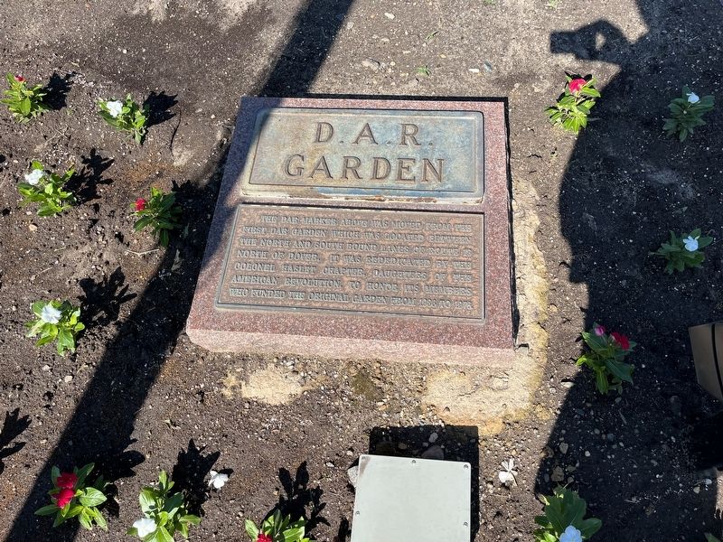
The DAR marker above was moved from the first DAR garden which was located between the north and south bound lanes of Route 13 north of Dover. It was rededicated by the Colonel Haslet Chapter, Daughters of the American Revolution, to honor its . . . — — Map (db m198992) HM
Born in 1740 in Dover, Kent Co., DE
Died Feb, 15, 1791 in Dover, Kent Co., DE
Justice of the Peace
Member of Joint Committee of Accounts, Committee of Correspondence, Council of Safety, and General Assembly. — — Map (db m42754) HM
On Delaware Street at 3rd Street, on the left when traveling south on Delaware Street.
Built in 1732 as the statehouse for Pennsylvania's "Three Lower Counties on the Delaware," the New Castle Court House was the scene of a dramatic vote on June 15, 1776 when the colonial assembly declared independence from both Great Britain and . . . — — Map (db m102546) HM
On Sunset Lake Road (Delaware Route 72) north of Dayett Mill Road, on the left when traveling north. Reported permanently removed.
During the American Revolution Lauzun's Legion
spent the winter and spring of 1782-1783 in Wilmington to help guard Philadelphia and Baltimore from British attack. The troops were housed in the Wilmington Academy, located where the Grand Opera . . . — — Map (db m209340) HM
On North Market Street south of East 9th Street, on the left when traveling south.
During the American Revolution Lauzun's Legion spent the winter and spring of 1782-1783 in Wilmington to help guard Philadelphia and Baltimore from British attack. The troops were housed in the Wilmington Academy, located where the Grand Opera . . . — — Map (db m166673) HM
Near Delaware Avenue (Delaware Route 52) east of North Adams Street, on the right when traveling west.
In honored memory
of
Gunning Bedford Jr.
Signer of the
Constitution of the United States
by the
Delaware State Society, NSDAR,
in this
Bicentennial year 1987 — — Map (db m216018) HM
On Chipman’s Pond Road (County Road 465) near Christ Church Road (County Road 465A), on the right when traveling west.
First native son of Laurel to be Governor of Delaware 1805-1808
Hero of the Revolution 1775-1781
Member, Continental Congress 1786-1788. — — Map (db m61107) HM WM
On Chipman's Pond Road (County Road 465) at Christ Church Roads (County Road 465A) on Chipman's Pond Road.
This Federalist served as the governor of Delaware between 1805-1808. He was born in Laurel in 1752, attended Old Christ Church, and is buried in this churchyard. Mitchell was commissioned as adjutant of militia 1775, promoted captain in 1776, and . . . — — Map (db m39779) HM
Lewes has been a Port-of-Call and a Harbor-of-Refuge since the 17th century. For generations during the ages of sail, a public burial ground in this immediate locality became the final resting place for hundred of sailors who lost their lives and . . . — — Map (db m176163) HM
On Second Street near Mulberry Sreet, on the right when traveling east.
In this house lived Ryves Holt
Chief Justice
of “Three Lower Counties On Delaware,”
1745 to 1763
Member of Assembly
of “Three Lower Counties On Delaware,”
1734-1737, 1742-1744, 1746-1755,
And Speaker of Assembly . . . — — Map (db m221639) HM
On Columbus Circle Northeast near Louisiana Avenue Northeast.
Dedicated by Maryland State Society, Daughters of the American Revolution, April 21, 1934. Growing on land that was once a part of Maryland and was in 1790 her gift to the United States of America for the national capitol, the 31 trees in this group . . . — — Map (db m186804) HM
On Eastern Avenue Northeast at Southern Avenue Northeast, on the left when traveling east on Eastern Avenue Northeast.
Original Federal Boundary Stone
District of Columbia
Placed 1791-1792
Protected by Dist. of Co. Chapter
Daughters of the American Revolution
1916 — — Map (db m190187) HM
Near 16th Street Northwest north of Crescent Place Northwest, on the right when traveling north. Reported missing.
The stone marking the Washington Meridian was formerly located 52 feet, nine inches west of this tablet which was presented by the Army and Navy Chapter, Daughters of the American Revolution. — — Map (db m82518) HM
On I Street Northwest west of 20th Street Northwest, on the right when traveling west.
Built in 1802 This house was the home of James Monroe Lieutenant-Colonel in the American Revolution
While Secretary of State and of War under Madison, and for the first six months of his administration as fifth President of the United . . . — — Map (db m97526) HM
On Massachusetts Avenue Northwest east of Q Street Northwest, on the right when traveling east.
The Society of the Cincinnati was founded in 1783 by the officers of the Continental Army to perpetuate their fellowship, preserve the memory of the Revolutionary War and promote the principles for which they had fought. The Society is named . . . — — Map (db m89464) HM
On 18th Street Northwest south of D Street Northwest, on the right when traveling north.
Constitution Hall
has been designated a
National
Historic Landmark
This site possesses national significance
In commemorating the history of the
United States of America
1985
National Park Service
United States . . . — — Map (db m242229) HM
On F Street Northwest east of 19th Street Northwest.
Here lived for a time
John Marshall
1755 - 1835
Officer in the Revolutionary War 1775 - 1781
Envoy to France 1797 - 1798
Secretary of War - 1800
Secretary of State - 1800
Chief Justice of the United States 1801 - 1835
. . . — — Map (db m111747) HM
On 17th Street Northwest south of D Street Northwest, on the right when traveling south.
Memorial Continental Hall
has been designated a
Registered National
Historic Landmark
under the provisions of the
Historic Sites Act of August 21, 1935
This site possesses exceptional value
in commemorating or . . . — — Map (db m242228) HM
On C Street Northwest west of 17th Street Northwest, on the right when traveling west.
The NSDAR was founded in Washington DC on October 11, 1890. On April 17, 1929, Grace L. H. Brosseau, President General, National Society Daughters of the American Revolution, dedicated this memorial to the four founders of the NSDAR: Mary Desha, . . . — — Map (db m50836) HM
Near Rock Creek and Potomac Parkway Northwest south of Pennsylvania Avenue Northwest, on the right when traveling south.
One of the best preserved and least altered of old American canals, the Chesapeake and Ohio grew from Washington's vision of linking the valleys of the early west with the east by “ties of communication.”
The Potomac Company . . . — — Map (db m97477) HM
Near R Street Northwest just east of 30th Street Northwest, on the left when traveling east.
First State Regent of Indiana - 1891
Charter Member, NSDAR - 1891
Vice President General NSDAR - 1892
Historian General NSDAR - 1893 — — Map (db m189272) HM
On 33rd Street Northwest at N Street Northwest, on the left when traveling south on 33rd Street Northwest.
This tablet marks the last home of Stephen Bloomer Balch, D.D. An officer in the Revolution 1747-1833 To the youth under his academic guidance he gave military training and led them in active service. For fifty years he was a leader in the . . . — — Map (db m97760) HM
On Alaska Avenue Northwest at 16th Street Northwest, on the right when traveling north on Alaska Avenue Northwest.
On May 30, 1920, Memorial Day, a crowd including many veterans gathered at this intersection to dedicate the first of 507 Norway maples that would make up DC's 16th Street World War I Tree Memorial. Assistant Secretary of War Benedict Crowell . . . — — Map (db m243284) HM
Near E Street Southeast east of Potomac Avenue Southeast, on the right when traveling east.
General Peterson Goodwyn equipped his own company and was cited for gallantry at the battles of Smithfield and Great Bridge — member of the Virginia House of Delegates 1789 – 1802, elected as a Democrat to the eighth and seven succeeding Congresses . . . — — Map (db m80692) HM
On County Road 236 NW, 0.3 miles west of Interstate 75, on the right when traveling west.
The construction of this road was authorized by the 18th Congress and approved February 28, 1824. The section from Tallahassee to St. Augustine was built by John Bellamy and followed the Old Spanish Road. — — Map (db m93361) HM
On NE Cholokka Boulevard north of SE Tuscawilla Road, on the right when traveling north.
Built 1853 by Dr. James A. Cooper as first apothecary shop. Later became the stagecoach stop and first post office. Old stage route entered Micanopy from west on present Seminary Street. First telephone office was also here.
Placed by . . . — — Map (db m175405) HM
On West King Street (State Road 520) west of South Cocoa Boulevard (U.S. 1), on the right when traveling west.
One half mile to the west ran the Hernandez Trail used during the Seminole War. It connected forts along the East Coast to Ft. Dallas in Miami and across from Ft. Pierce and Ft. Capron to Ft. Brooke near Tampa. Brig. General Joseph M. Hernandez, . . . — — Map (db m72606) HM
Little Red Schoolhouse
Melbourne's oldest surviving schoolhouse
built 1883 by John Goode at his house on the river.
Both black and white students, attended 5-6
summer months, sat on benches. Wrote on
slates, drank from well near by. . . . — — Map (db m241654) HM
Near West New Haven Avenue (U.S. 192) at McClain Drive, on the right when traveling west.
The Hernandez-Capron Trail parallels I-95 here in Brevard County. Laid out in 1838 by U.S. Army during Second Seminole war, it linked King's Road in St. Augustine and forts along St. John's River with Ft. Capron, 4 mi. north of present Ft. Pierce. . . . — — Map (db m75839) HM
On Ocean Aveune east of Riverside Drive, on the left when traveling west.
One of the first homes in Melbourne Beach, the Ryckman House was built in 1890 for Jacob Fox by Captain Rufus W. Beaujean. Both men were original investors in the Melbourne Beach Company, later named the Melbourne Beach Improvement Company. The . . . — — Map (db m93164) HM
Near South Sykes Creek Parkway, 0.1 miles south of Fortenberry Road, on the right when traveling north.
Dedicated by the National Society of the Daughters of the American Revolution with deepest appreciation for the tremendous sacrifices made by America’s Women Veterans — — Map (db m164618) WM
Near South Sykes Creek Parkway south of Fortenberry Road, on the left when traveling south.
This marker commemorates the men and women who achieved American independence. These Patriots, believing in the noble cause of liberty, fought valiantly to found a new nation.
1775 – 1783
Presented by Brevard Space Coast Regents . . . — — Map (db m217722) HM WM
Near South Sykes Creek Parkway at Fortenberry Road, on the left when traveling south.
The last naval battle of the American Revolutionary War took place off the coast of Cape Canaveral on March 10, 1783. The fight began when three British ships sighted two Continental Navy ships, the Alliance commanded by Captain John Barry . . . — — Map (db m217593) HM
On South Palm Avenue at Pine Street, on the right when traveling south on South Palm Avenue.
To the honor
of
Brevard County boys
who gave
their services
in the World War
This tablet is dedicated
in gratitude and pride
by
Phillip Perry Chapter
Daughters of the American Revolution
Titusville, Florida . . . — — Map (db m164318) WM
On Northeast 8th Street at Memorial Drive, in the median on Northeast 8th Street.
Graduated from Fort Lauderdale High School 1937 and from United States Military Academy at West Point with Honors 1941.
Awarded Posthumously the First Congressional Medal of Honor of World War II by President Franklin D. Roosevelt on January . . . — — Map (db m146548) HM
Near Southeast 6th Avenue at Southeast 4th Avenue, on the right when traveling south.
On this spot, January 31, 1893, Frank Stranahan, the founder of this city, conducted a ferry across New River, established a trading post with the Indians and operated the first U.S. Post Office.
Seven tenths of a mile west of this point . . . — — Map (db m100795) HM
Near Southeast 6th Ave at Southeast 4th Avenue, on the right when traveling south.
Born at White Springs, Florida, on the banks of the Suwannee River, came to Fort Lauderdale, Florida in 1899 as the town's first school teacher. She married Frank Stranahan in 1900 and lived at the Indian Trading Post on New River, where she . . . — — Map (db m100385) HM
Near Seabreeze Boulevard (Florida Route A1A) at Sahia Mar.
This tablet marks the site of the Third "Fort Lauderdale" named in honor of Maj. Wm. Lauderdale, Cmdr. Tenn. Vol.
Built in 1839 under the command of Captain William B. Davidson during the Second Seminole War
First erected by the Himmarshee . . . — — Map (db m171849) HM
Near North Ocean Boulevard (Florida Route A1A) just north of Bay Drive.
In 1901, the U.S. Congress approved funding for a light near Hillsboro Point to fill a 90-mile void between the town of Jupiter and the Cape of Florida. Manufactured in Detroit, Michigan and reassembled at the Hillsboro Inlet in 1906. The . . . — — Map (db m172172) HM
Near Tamiami Trail (U.S. 41) 0.1 miles south of County Route 776A.
In 1905, Clarence Bloomfield Moore (1852-1936), a wealthy, amateur archaeologist from Philadelphia excavated a mound located on the northern bank of the Peace River about one half mile north of this site. Moore found the sand burial mound containing . . . — — Map (db m152615) HM
On East Orange Avenue (County Road 48) at South Old Floral City Road, on the right when traveling east on East Orange Avenue.
In 1863 John Paul Formy-Duval and his wife Elizabeth Ann Trantham bought land from Allen Munden and began building their home. During the process of construction, the Duvals discovered that they had been building their house a few hundred yards . . . — — Map (db m119137) HM
On North Florida Avenue (U.S. 41) at East Parsons Point Road, on the right when traveling north on North Florida Avenue.
The Hernando Elementary School is a one-story masonry building erected between 1941 and 1942 through county and state cooperation with the Works Progress Administration (WPA). This red brick school is situated on land that was acquired through a . . . — — Map (db m236678) HM
On South Old Floral City Road, 0.2 miles south of Carnegie Drive, on the right when traveling south.
Fort Cooper was constructed in April 1836 during the Second Seminole War. General Winfield Scott instructed the First Georgia Battalion of Volunteers under the leadership of Major Mark Anthony Cooper to build two bastions and a blockhouse on the . . . — — Map (db m93258) HM
On Marion Avenue (SR 47) (U.S. 441) near NW Orange Street, on the left when traveling south.
The Apalachee Indian Trail of early times
passed in this vicinity through Alligator -
now Lake City - to near the upper mineral
springs - White Springs - on to Tallahassee
via Alapaha.
This marker commemorates, also, the historically . . . — — Map (db m57642) HM
On West Oak Street at DeSoto Avenue (U.S. 17), on the right when traveling west on West Oak Street.
The Arcadia Historic District comprises fifty-eight blocks within 340 acres that embody the city's development from the founding of its post office in 1883 through the late 1920s. The Town of Arcadia was incorporated in 1886 following the arrival of . . . — — Map (db m110674) HM
On Heckscher Drive (State Road 1A) south of Fort George Road, on the right when traveling south.
Jean Ribaut and a party of Huguenots landed the morning of May 1, 1562 on this island. Here they knelt in prayer, beseeching God's guidance and commending the natives to his care. This was the first Protestant prayer in North America. — — Map (db m40024) HM
On Brady Road south of Mandarin Road, on the left when traveling south.
(side 1)
James Hall
Soldier of the Revolution
James Hall was born on October 8, 1760, in Keene, New Hampshire. Records of the Continental Army indicate that James Hall of Keene was mustered into service about August 20, 1776. . . . — — Map (db m171493) HM WM
On Atlantic Boulevard (U.S. 90) at White Avenue, in the median on Atlantic Boulevard.
Fifteen hundred thirty feet
north of this spot stood an
early Spanish fortification
- Fort San Nicholas -
Abandoned July 4, 1817
This marker erected by Jacksonville Chapter D.A.R. — — Map (db m220558) HM
Near Ft. Caroline Road, on the left when traveling east.
(Front): This is a replica of the marker placed on or near this spot by Jean Ribaut May First 1562 in taking possession of Florida for France. (Back): Erected by the Florida Daughters of the American Revolution May First 1924 . . . — — Map (db m46578) HM
The King's Road, built by the British prior to the American Revolution, began at the St. Mary's River, passed through Cowford (Jacksonville), crossed the St. John's River, it is believed, at present day Liberty Street, approximately one mile east of . . . — — Map (db m60398) HM
On W.Duval St. at N. Laura Street, on the left when traveling west on W.Duval St..
At this spot the Kings Road met the Apalache Trail, so connecting the English colonies and the Spanish settlements of the west with St. Augustine and New Smyrna — — Map (db m138343) HM
Near Riverplace Boulevard (State Road 13) at Flagler Avenue.
General John McIntosh (c.) 1756-1826 was born in Darien Georgia. He assisted botanist William Bartram 1773-1774, and in 1774 they explored along the St. Johns River. His activities during the Revolutionary War included serving as a captain, . . . — — Map (db m138114) HM
Near 1st Street South north of 5th Avenue South, on the right when traveling north.
On April 10, 1942, German submarine U-123 torpedoed the oil tanker SS Gulfamerica off the coast of Jacksonville Beach. The tanker exploded and eventually sank. Nineteen Americans lost their lives in the attack. This marker has been placed to . . . — — Map (db m181086) HM WM
On West La Rua Street at North Palafox Street, on the left when traveling east on West La Rua Street.
On March 9, 1781, Spanish General Bernardo de Galvez, with a fleet of some 30 ships, arrived opposite Pensacola Bay and within a day took Santa Rosa Island. On March 18, Galvez, in his ship Galveztown, sailed under the cannon of the Royal Navy . . . — — Map (db m72252) HM
On Bayshore Boulevard at South Plant Avenue, on the right when traveling south on Bayshore Boulevard.
Clarissa 'Clara' Harlowe Barton traveled through Tampa, in 1898, on her way to and from Cuba during the Spanish American War. Barton often stayed at the home of J. Mack Towne, which was located just north of this marker at 350 Plant Avenue. There . . . — — Map (db m156548) HM
Near University Drive near West Kennedy Boulevard..
1539 1926
[ DAR Emblem ]
This Tablet Erected By
De Soto Chapter
D.A.R.
Marks the tree under which tradition say's
De Soto
Parleyed with the Indians — — Map (db m20789) HM
On University Drive east of North Brevard Street, on the left when traveling west.
Built circa 1855 by Gen. Jesse Carter for his daughter Josephine. He employed Mrs. Louisa Porter as teacher. The first class included Josephine Carter, Janie Givens, Mary Lesley, Mary Kelly, Eugenia Spencer, Lizzie Spencer and Hayden Porter. Jessie . . . — — Map (db m33902) HM
Late in July, 1715, a hurricane destroyed a fleet of eleven or possibly twelve homeward bound merchant ships carrying cargoes of gold and silver coinage and other valuable items from the American colonies to Spain. About 1500 men, women, and . . . — — Map (db m14306) HM
On State Road 60 (State Road 60) 0.6 miles east of 130th Avenue, on the right when traveling east.
A few miles southwest of this marker is the site of Fort Vinton. As white settlers moved into Florida, demands increased for the removal of the Seminole Indians to a western reservation. The Seminoles did not wish to leave, and in 1835 the conflict . . . — — Map (db m212677) HM
The land upon which Goodwood Mansion was constructed was part of the original land grant rewarded to the Marquis de Lafayette for his service during the Revolutionary War. Hardy Croom of North Carolina, a planter and recognized naturalist, purchased . . . — — Map (db m67032) HM
On E. Park Ave. close to S. Monroe Street, in the median.
Between 1832 and 1833 the following men applied in Tallahassee, Leon County, Florida, for federal pensions granted for their military service during the American War for Independence Zachariah Gherkins (1757-1845) Served as a Private with . . . — — Map (db m73051) HM WM
On Mahan Drive (U.S. 90) 0.1 miles east of Arendell Way, on the right when traveling west. Reported missing.
Side 1
During the American War of Independence, the Marquis de Lafayette came from France to the United States to offer not only his personal services as a major general in the Continental Army but also some $200,000 of his private fortune . . . — — Map (db m146794) HM
On East Fort King Street at Southeast 39th Avenue, on the right when traveling west on East Fort King Street.
This marks the burying ground of the soldiers and civilians who died at Fort King during the Seminole War 1835-1842.
Fort King occupied the hill to the north-east and was established as a military post in 1827. — — Map (db m92978) HM
Near East Fort King Street at SE 39th Avenue, on the left when traveling east.
A timeless memorial to those who
Lost Their Lives
at Fort King.
In 1927, the Marion County Chapter of the Daughters of the American Revolution had the great forethought to sign a title transaction that deeded this . . . — — Map (db m221845) HM
Three miles to the east on September 23, 1696, the British barkentine Reformation foundered off Jupiter Island. The 24 survivors included a party of Quakers bound from Jamaica to Pennsylvania. Leader of the Quakers was Jonathan Dickinson who . . . — — Map (db m14311) HM
On SE Krueger Creek Place at SE Ocean Boulevard (Florida Road A1A), on the right when traveling south on SE Krueger Creek Place.
A lasting monument to the original settlers and
early pioneers of Potsdam (now Stuart) Florida
Annie (Speirs) and Albert Krueger
This property has been listed in the
National Register of Historic Places
by the United States . . . — — Map (db m193689) HM
On Southeast MacArthur Boulevard, 1 mile south of Northeat Plantation Road, on the left when traveling south.
Europeans arriving at Hutchinson Island in the 16th century found the island populated by hundreds of Native Americans living in settlements bordering both the Atlantic Ocean and the Indian River.
The rich marine environment provided these . . . — — Map (db m106588) HM
On Miracle Mile at Merrick Way, on the right when traveling west on Miracle Mile.
Incorporated April 29, 1925
Originated in 1898 as the Plantation
of Reverend S.G. Merrick
Founded and building begun by George E. Merrick
November 1921 — — Map (db m127511) HM
On Coral Way at Toledo Street, on the right when traveling west on Coral Way.
In July 1899, Congregational minister Solomon Greasley Merrick (1859-1911) and his wife Althea (1859-1937) purchased sight unseen the surrounding 160 acres for $1,100. Several months later, Merrick and his son George (1886-1942) came from . . . — — Map (db m73631) HM
On Castile Avenue at South Greenway Drive, on the right when traveling west on Castile Avenue.
Site of Packing House
of
Coral Gables Plantation
established by
Rev. Solomon Greasley Merrick
Post in fig tree
only evidence remaining — — Map (db m73634) HM
Standing at the highest point on the island, the Amelia Island Lighthouse was built from bricks re-used from the Cumberland Island Lighthouse in 1839 on land purchased from Mary Fernandez. The 67 foot tall lighthouse has walls four feet thick at the . . . — — Map (db m33367) HM
On Atlantic Avenue (State Road A1A) at North Wolff Street, on the right when traveling west on Atlantic Avenue.
This site was part of an indigo plantation belonging to the estate of John Perceval, 2nd Earl of Egmont. After Lord Perceval’s death in 1770, his executors sent Stephen Egan to manage the East Florida estate. Under Egan’s supervision, Egmont became . . . — — Map (db m106652) HM
On South 11th Street at Atlantic Avenue (State Road A1A/200), on the right when traveling north on South 11th Street.
In honor of
American Revolutionary War Patriots
who settled in Nassau County, Florida
Burroughs Higginbotham, Soldier
Amos Latham, Soldier
John Tolson Lowe, Lieutenant
James Pelot, Patriot
John Daniel Vaughan, Private
For freedom, . . . — — Map (db m93831) WM
On Center Avenue east of Front Street, on the left when traveling west.
In May 1777, Colonel Samuel Elbert's Continentals landed on the North End of Amelia Island at Oldtown Bluff, approximately one mile north of Florida. A patrol engaged in a skirmish with British troops on the south end of the island. An officer, Lt. . . . — — Map (db m33414) HM
Near Miracle Strip Parkway, SE (U.S. 98) west of Pier Road, on the right when traveling west.
This marker commemorates the
men and women who achieved
American independence.
These Patriots, believing in the
noble cause of liberty, fought
valiantly to found a new nation.
1775 - 1783
Presented by
Choctawhatchee Bay . . . — — Map (db m192301) HM
On Southeast 38th Avenue, 0.2 miles north of U.S. 98/441, on the right when traveling north.
In these woods on Christmas Day 1837, was fought the Battle of Okeechobee, in which a large band of Seminole Indians, under Chief Wild Cat, Alligator, and Sam Jones was routed by a brigade led by Colonel Zachary Taylor, consisting of the First, . . . — — Map (db m97075) HM WM
On Southeast 38th Avenue, 0.2 miles north of Route 98/441, on the right when traveling north.
The Battle of Okeechobee Historic State Park is located on a portion of the actual battleground of the Second Seminole War's fiercest battle. Federal and volunteer soldiers, led by colonel Zachary Taylor, were part of a large army attempting to . . . — — Map (db m220350) HM WM
On S. Orlando Avenue (U.S. 17 & 92) at Lake Lily Drive, on the right when traveling north on S. Orlando Avenue.
Fort Maitland
was built in November 1838 by Lt. Col. Alexander C. W. Fanning, U.S.A. (1788-1848) on the military road connecting Fort Melon (Sanford) with Fort Gatlin (Orlando) and used as a stockade in the war between the United States and the . . . — — Map (db m7452) HM
Near E. Washington Street, 0.1 miles west of N. Eola Drive.
In memory of the Orange County boys who gave their lives in the World War.
Erected by the Orlando Chapter - Daughters of the American Revolution, aided by patriotic citizens of Orange County, 1924. — — Map (db m7420) WM
Patriots Of The
American Revolution
1775 - 1783.
Heroes Of Liberty
Daughters Of The
American Revolution
Orlando Chapter
Dedicated June 12, 2010 — — Map (db m143559) WM
On Rouse Road south of Riverbank Boulevard, on the right when traveling south.
This family cemetery stands on land that was originally part of 77 acres that was homesteaded by the Drawdy family, made possible by the Homestead Act of 1862. Two acres were set aside for a cemetery for the Drawdy family and local pioneers. . . . — — Map (db m219445) HM
Near North Ocean Boulevard (State Road A1A) 0.5 miles south of Northeast Spanish River Boulevard (State Road 800), on the right when traveling south.
Along this beach in the 1880’s and early 1890’s walked United States mailmen on their sixty-six mile journey between Palm Beach and Miami. The trip required three days each way and they passed this spot the second day. They walked barefoot at the . . . — — Map (db m96964) HM
On North Ocean Boulevard (State Road A1A) 0.1 miles south of Thomas Street, on the right when traveling north.
One of several built by Treasury Department between Cape Canaveral and Cape Florida for rescue and sustenance of shipwrecked. Named for wild sour orange grove nearby, H.D. Pierce, first keeper, arrived with family May 1876. Here August 15, 1876, was . . . — — Map (db m96919) HM
On Ocean Drive (State Road A1A) at Erikson Way, on the left when traveling north on Ocean Drive.
As a memorial to the pioneers of this section of Florida. On this spot the Celestial Railroad, once connecting Jupiter with Juno, is crossed by the Federal Highway.
Juno, at the north end of Lake Worth was the county seat of Dade County, then . . . — — Map (db m97052) HM
3241 entries matched your criteria. Entries 301 through 400 are listed above. ⊲ Previous 100 — Next 100 ⊳