814 entries match your criteria. Entries 301 through 400 are listed.⊲ Previous 100 — Next 100 ⊳
Texas 1936 Centennial Markers and Monuments Historical Markers
In 1935/1936 the State of Texas Legislature created a commission to celebrate the 100th anniversary of Texas independence from Mexico. Part of this consisted of placing about 1,100 statues, and granite and bronze markers and monuments around Texas. See more at the Texas Historical Commission website 1936 Texas Centennial Markers.
On State Highway 136, 1.5 miles north of Farm to Market Road 520, on the left when traveling north.
Established by James H. and Bob Cator in the spring of 1872 while hunting buffalo in the fall of 1875. The camp became a trading post known as Zulu. — — Map (db m93405) HM
On Northwest Court Street at Main Street, on the right when traveling east on Northwest Court Street.
Formed from Young and Bexar
territories
Created, August 21, 1876
Organized, March 11, 1889
Named in honor of
John M. Hansford
came to Texas in 1837
Member of the Texas Congress
Judge of the Seventh Judicial
District, . . . — — Map (db m169535) HM
On West 11th Street west of Hughes Street, on the right when traveling west.
Created February 1, 1858
Recreated August 21, 1876
Organized December 30, 1884
Named in honor of
Bailey Hardeman, 1785-1836,
signer of the
Texas Declaration of Independence,
and
Thomas Jones Hardeman, 1788-1854
member of . . . — — Map (db m104891) HM
On State Highway 326, on the right when traveling east.
Created January 22, 1858 Organized August 9, 1858 Named in honor of the Hardins of Liberty County, five brothers - Benjamin Watson, Augustine Blackburn, William, Franklin and Milton A. who came to Texas in 1825 County seat, Hardin, 1858-1887 . . . — — Map (db m44982) HM
On South Burnett Drive at Lakewood Drive on South Burnett Drive.
Born in Morriston, N.J., December 8, 1800; died in 1858. Wife of David G. Burnet, President Ad Interim of Texas, March 16 to Oct. 22, 1836. — — Map (db m239906) HM
On De Zavalla Road, 1 mile east of Lakeside Drive, on the right when traveling east.
Signer of the Texas Declaration of Independence. Vice President of the Republic of Texas. His plank-covered log house, the first in the municipality of Harrisburg, built in 1829, served as a hospital for the wounded after the Battle of San Jacinto. . . . — — Map (db m239905) HM
Near Center Street at West Helgera, on the left when traveling north.
Site of the home
in 1836 of
Dr. George
Moffit Patrick
1801-1889
Pioneer surveyor • Here the Texas
Army encamped after the Battle
of San Jacinto and cabinet meet-
ings were held — — Map (db m53323) HM
On Valentine Street at West Dallas Street, on the right when traveling south on Valentine Street.
Arrived in Texas
January 28, 1836, having been
recruited in New Orleans
for the Army of Texas by
Captain Amasa Turner in
whose company he served
at San Jacinto.
Died in Houston, 1837. — — Map (db m59589) HM
On Valentine Street, on the right when traveling south.
Served in Captain Henry W.
Karnes' company of Cavalry
at San Jacinto. Died in
Houston, June 1, 1840
His wife
Eliza Sneed Secrest
Died in 1839 — — Map (db m129952) HM
On Valentine Street, on the right when traveling south.
Came to Texas in
January, 1836
Fought at San Jacinto in
Captain Richard Roman's
company
Born in Kentucky, 1806
Died in Houston
July, 1846 — — Map (db m129949) HM
On Saulnier Street, on the right when traveling west.
Commodore of the
Texan Navy
Died in Houston, Nov. 1, 1837
"The funeral of the late
Commodore Thompson took
place on the morning of
Thursday last. His remains
were followed to the grave
by the largest and most
respectable . . . — — Map (db m129917) HM
On West Dallas Street, on the right when traveling east.
Born in Tennessee, 1806. Drowned in Galveston, July 11, 1839, and his remains brought by boat up Buffalo Bayou to Houston. His remains interred in this cemetery under the auspices of Temple Lodge No. 4. First Masonic funeral ever held in Texas . . . — — Map (db m129870) HM
On Saulnier Street, on the right when traveling west.
Came to Texas in 1829
Died in Houston in 1846
Participated in the Battle
of San Jacinto as a member
of Captain Thomas H.
McIntire's company — — Map (db m129919) HM
On West Dallas Street, on the right when traveling east.
Born in Canasareaugh, New York 1810. Came to Texas in 1832. Died in Houston August 18, 1838
John K. Allen was a member of the first Congress of the Republic (1836-1837) from Nacogdoches County. He and his brother, Augustus C. Allen, on August . . . — — Map (db m129873) HM
On West Dallas Street, on the right when traveling east.
Opposed Bradburn at Anahuac
1832. Member of the Consul-
tation at San Felipe in 1835.
Signer of the Declaration of
Independence, 1836. First
sheriff of Harris County, 1837
to 1840. City alderman in
Houston, 1840. Married to
Eliza . . . — — Map (db m129910) HM
On Valentine Street, on the right when traveling south.
Born in Georgia. Came to Texas
in 1834. Storming of Bexar, 1835.
Commanded the artillery at
San Jacinto. Made Major, July
20, 1836. Law partner of David
G. Burnet, 1837. Died June 7, 1840
while Chief Justice of Harris
County. Buried . . . — — Map (db m129950) HM
On West Dallas Street, on the right when traveling east.
San Jacinto veteran.
Postmaster General of
the Republic under
Houston and Lamar.
Born in Urbana, Ohio
in 1802. Died in
Houston, Texas at 9
a.m. October 11, 1839, of
yellow fever. Buried
under the auspices of
the Masonic and . . . — — Map (db m129915) HM
On Saulnier Street, on the right when traveling west.
Born in Kentucky. Arrived at
Velasco, January 28, 1836 on the
schooner Pennsylvania to fight
for the freedom of Texas. A
member of Captain Amasa Turner's
company at San Jacinto. Died in
Houston, December 24, 1839
"Kiss William . . . — — Map (db m129971) HM
On Saulnier Street, on the right when traveling west.
Born in England in 1814
Participated in the capture
of Bexar, December 5th to
10th, 1835. Served in
Captain William J. E. Heard's
company at San Jacinto
and was Second Lieutenant
in the Milam Guards when
he died at Houston, Aug- . . . — — Map (db m129916) HM
On Valentine Street, on the right when traveling south.
Born in Scotland.
Fought at San Jacinto
in Captain A. H. Wyly's
company. Died in
Houston, April 10, 1869
and was buried here.
His widow
Jane McDaniel
Gammell
Died November 11, 1908
and was buried in the
Glenwood . . . — — Map (db m129951) HM
On Saulnier Street, on the right when traveling west.
A Private in Captain Isaac
N. Moreland's company of
Artillery at San Jacinto.
Appointed Captain, December
26, 1836. Born in New York
1809. Died in Houston
September 12, 1837
"Died in this city, on the
12th inst., suddenly, . . . — — Map (db m129954) HM
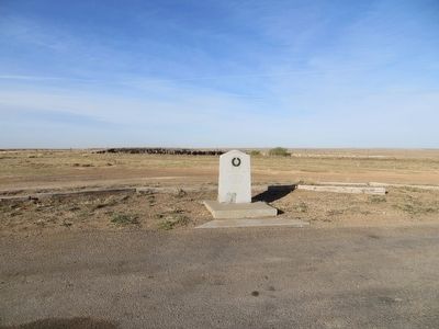
On Lawndale Street, 0.8 miles east of Allen Genoa Road, on the left when traveling east.
3000 ft. north at this site. The Texas Army under command of General Sam Houston crossed Buffalo Bayou on April 19, 1836 on a raft built from Isaac Batterson's house and began the march which terminated with the victory at San Jacinto April 21, 1836 — — Map (db m236107) HM
On Park Road 1836, on the right when traveling south.
A member of Captain Thomas H. McIntire's company at San Jacinto.
Died at Lynchburg in 1839 and was buried near his comrades who fell in battle. — — Map (db m125926) HM
On Park Road 1836 North west of Independence Parkway, on the left when traveling north.
Came to Texas in October, 1835. Fought at San Jacinto in Captain Thomas H. McIntire's company. Died at Lynchburg, August 6, 1836. — — Map (db m90110) HM
Near Park Road 1836, on the left when traveling north.
Participated in the capture
of San Antonio in 1835 and
served in the army in 1836
Born in New York in 1799
Died in Harris County,
Texas in 1870 — — Map (db m126009) HM
On Independence Parkway, on the right when traveling north.
The Mexican Cavalry was on the left wing, Infantry and Artillery in the center behind a fortification of boxes and baggage, while the extreme right was far extended. — — Map (db m125905) HM
On Independence Parkway at Juan N Seguin Boulevard (Vista Road), on the right when traveling south on Independence Parkway.
Near here on the afternoon of April 21, 1836, the army of The Republic of Texas commanded by General Sam Houston was drawn up to attack an invading Mexican army commanded by General Antonio Lopez de Santa Anna. — — Map (db m125909) HM
On Independence Parkway, 0.8 miles north of Pasadena Freeway (State Highway 225), on the left when traveling north.
The Texas Army attacked in four divisions; the Cavalry on the right, commanded by Mirabeau B. Lamar; next, the Infantry under Lieutenant Colonel Henry Millard; the “Twin Sisters” cannon under Colonel Edward Burleson; the 2nd Regiment, . . . — — Map (db m125883) HM
On Independence Parkway at Juan N Seguin Boulevard (Vista Road), on the right when traveling south on Independence Parkway.
To the tune of “Will You Come to the Bower,” the Texans advanced; “Remember the Alamo! Remember Goliad!” was their cry. With cannons and gunshot, clubs and Bowie knives they fought — no quarter was given; the rout . . . — — Map (db m125908) HM
On Independence Parkway, on the right when traveling north.
Within a few minutes the Battle of San Jacinto was over. According to General Houston's report 630 Mexicans lay dead on the field, 208 were wounded and 730 were taken prisoners. Money, arms and equipment were captured. The Texans had 9 killed and 30 . . . — — Map (db m125906) HM
On Independence Parkway at Decker Drive (State Highway 330 Spur), on the right when traveling north on Independence Parkway.
Established before 1824 by
Nathaniel Lynch
one of Austin's first colonists
on land granted August 19, 1824.
Granted exclusive privilege to
operate ferry at this point
January 1, 1830, by Ayuntamiento
of San Felipe. Now known as . . . — — Map (db m168757) HM
On Decker Drive (State Highway 330 Spur), on the right when traveling east.
Home of David G. Burnet (1788-1870). First President of the Republic of Texas. To Oakland he brought his bride in 1831 and there they and their son William wrested a livelihood from the soil. — — Map (db m168756) HM
On New Kentucky Park Drive, 0.2 miles north of Waller-Tomball Road (Farm to Market Road 2920), on the left when traveling north.
Established before 1831. A thriving
town until its trade was captured
by the present city of Houston,
established 30 miles away in 1836.
Abandoned about 1840. — — Map (db m140283) HM
Near U.S. 80, 0.8 miles west of County Road 2199, on the right when traveling west.
Formed from Shelby County
Created January 28, 1839 Organized June 12, 1842
Named in honor of
Jonas Harrison
A pioneer statesman of New Jersey
who came to Texas in 1820
A member of the First Convention of . . . — — Map (db m119552) HM
On East Grand Avenue (U.S. 80) at North Columbus Street on East Grand Avenue.
Associate Justice of the Supreme Court, Republic of Texas, 1839-40, 1842-45; district judge, state of Texas, 1846-50. Mills County, Texas was named in his honor. Born in County Antrim, Ireland, Nov. 12, 1817; died Nov. 30, 1871. Octavia (Jones) . . . — — Map (db m218653) HM
On West Houston Street at Adkins Street, on the right when traveling east on West Houston Street.
A pioneer institution of higher education, incorporated January 19, 1842. Granted four leagues of land for its support by the Republic of Texas. The leading educational institution in northeast Texas until the Civil War. It later became a part of . . . — — Map (db m232691) HM
Near U.S. 87 at County Route K, on the right when traveling north.
Formed from Young and Bexar
Territories
Created August 21, 1876
Organized February 5, 1891
Named in honor of two brothers Oliver Cromwell and
Rufus K. Hartley
Distinguished members of the
Texas Bar
Hartley, the . . . — — Map (db m93240) HM
Near S. Avenue E (Business U.S. 277) at S. 1st Street, on the right when traveling north.
Created February 1, 1858
Recreated August 21, 1876
Organized January 13, 1885
Named in Honor of
Charles Ready Haskell, 1817-1836
A Tennesseean who was shot with
Fannin in the Massacre at Goliad
Haskell, the County Seat
. . . — — Map (db m82083) HM
On North Old Bastrop Highway (County Route 266) 1.2 miles south of San Marcos Highway (Texas Highway 80), on the right when traveling south.
Known officially as Villa de San Marcos de Neve. Established in 1807 by Mexican settlers. The population on January 6, 1808 was 81. A flood in 1808 and subsequent Indian raids led to its abandonment in 1812 — — Map (db m76023) HM
On U.S. 60 north of 6th Street, on the right when traveling west.
Formed from Young and Bexar
Territories
Created August 21, 1876
Organized July 5, 1886
Named in honor of
John Hemphill, 1809-1862
First Chief Justice of the Supreme
Court of the State of Texas
Adjutant General of the
Somervell . . . — — Map (db m55742) HM
On South Palestine Street (State Highway 19) 0.2 miles East Cayuga Drive (Farm to Market Road 59), on the right when traveling north.
Formed from Houston
and Nacogdoches counties.
Created April 27, 1846,
Organized August 4, 1846.
Named in honor of
James Pinckney Henderson
1808-1858
First governor of
the State of Texas
Buffalo, Centerville and Athens . . . — — Map (db m186666) HM
On North First Street at Old Military Road, on the right when traveling north on North First Street.
County seat of Hidalgo County 1852 - 1908 • Known as Edinburgh in 1852 • • Name changed in 1861 to Hidalgo in honor of Miguel Hidalgo y Costilla, 1753 - 1811, Parish Priest who led the movement in 1810 for Mexican Independence • • Almost completely . . . — — Map (db m223843) HM
On North Waco Street (State Highway 81), on the left when traveling north.
Created February 7, 1855
Organized May 14, 1853
Named in honor of
Dr. George W. Hill
1814-1860
Member of the Texas Congress
and Legislature
Secretary of War of the
Republic of Texas, 1843-1845
Lexington, first village . . . — — Map (db m62522) HM
On Farm to Market Road 1946, 0.2 miles east of County Highway 3449, on the right when traveling west.
A Soldier in the Texas Army in 1836 • Born in Louisiana, February 20, 1811 • Died May 28, 1900
His Wife
Margaret Ann Addison
Born in Missouri, February
24, 1815 • Died July 26, 1878 — — Map (db m212064) HM
On U.S. 385 at Farm to Market Road 2306, on the left when traveling north on U.S. 385.
Formed from Young and Bexar
Territories
Created August 21, 1876
Organized February 19, 1921
Named in honor of
George W. Hockley
Commander of the artillery
at San Jacinto. Secretary
of War of the Republic of
Texas. Died in 1851. . . . — — Map (db m155396) HM
On Thorp Street at Caraway Street, on the right when traveling west on Thorp Street.
Chartered in 1873 under the name Add-Ran Christian College • Removed to Waco on December 25, 1895 • Reestablished at Fort Worth in 1909 as Texas Christian University — — Map (db m224667) HM
Near Church Street west of Loop State Highway 313.
Front
Home County of Texas Confederate General W. H. King
Georgian. Moved to Texas 1861. Rose to rank of colonel, 18th Texas Infantry. Led regiment in Red River Campaign of 1863 to prevent split of South along Mississippi. . . . — — Map (db m119776) HM
On Interstate 30 Frontage Road, 0.4 miles east of County Highway 3341, on the right when traveling east.
Formed from Lamar and Nacogdoches Counties Created March 25, 1846
Organized July 13, 1846
Named in Honor of the Pioneer Hopkins Family Which Came to Texas From Kentucky and Indiana
County Seat, Tarrant 1846-1858 Sulphur Springs, . . . — — Map (db m186645) HM
On Texas 21 at 1280, on the right when traveling south on Texas 21.
Established before 1836 Used by Elisha Clapp and neighboring settlers as a place of defense against the Indians Abandoned about 1844 — — Map (db m219447) HM
On 4th Street (State Highway 19) north of Wood Avenue, on the left when traveling north.
Created from Nacgodoches County
June 12, 1837
Organized the same year
named in honor of
Sam Houston
1793-1863
Commander-in-Chief of the Texan
Army at San Jacinto
President of the Republic and
Governor of the State of Texas . . . — — Map (db m63530) HM
Near East Pease Street, 0.2 miles west of Texas Highway 19.
A soldier in the Army of Texas, 1836 Chief Justice of Houston County, 1841 Born in Tennessee Feb. 1, 1788 Died Nov. 24, 1848 His wife Elizabeth (Stone) Gossett Born in Tennessee Sept. 1, 1789 Died July 6, 1849 — — Map (db m219482) HM
On East Pease Avenue, 0.2 miles west of Texas Highway 19.
Veteran of San Jacinto • Commander of the "Horse Marines" in June, 1836 • A Senator in the Congress of the Republic 1836-1839 • Born in Georgia in 1805 • Died in January, 1843 — — Map (db m219480) HM
On State Highway 21, 0.7 miles east of Farm to Market Road 3187, on the right when traveling west.
Built as a home by Joseph D. Rice, Sr., who came to Texas in 1828.
In 1838 it was designated as a stopping place for the stage coach from Nacogdoches to Crockett. — — Map (db m121249) HM
On Main Street south of 3rd Street, on the right when traveling south.
Formed from Young and Bexar
Territories
Created August 21, 1876
Organized June 15, 1882
Named in honor of
Volney Erskine Howard
1809 – 1889
Came to Texas in 1844
Delegate to the First State
Constitutional . . . — — Map (db m120477) HM
On U.S. 62/180, 3.4 miles east of Ranch to Market Road 1576, on the right when traveling east.
Resentment over private control of
the salt lakes in this region,
often called Guadalupe Lakes,
led to the El Paso Salt War
1877
which entailed the loss of many
lives and much property — — Map (db m61508) HM
On Sierra Blanca Avenue (Ranch to Market Road 1111) at El Paso Street (Business Interstate 10), on the right when traveling north on Sierra Blanca Avenue.
Formed from El Paso County
Created February 16, 1917
Organized August 25, 1917
Named in honor of
Claude Benton Hudspeth
Born in 1877
A native Texan
Holder of larger ranching interests
Member of the Texas Legislature
and the . . . — — Map (db m118227) HM
On Washington Street at Stonewall Street (State Highway 34), on the left when traveling east on Washington Street.
Created April 11, 1846
Organized July 19, 1846
Named in honor of
General Memucan Hunt
1807-1856
Secretary of the Navy and
Inspector General of the Army
of the Republic of Texas
Minister to the United
States
Adjutant . . . — — Map (db m119856) HM
On State Highway 152, 0.5 miles north of County Route 13, on the right when traveling north.
Fifteen miles to the site of the
Battle of Adobe Walls
Fought on November 25, 1864
between Kiowa and Comanche Indians
and United States troops
commanded by
Colonel Christopher Carson
1809 – 1868
This was "Kit" Carson's . . . — — Map (db m93256) HM
On U.S. 67 at Farm to Market Road 72, on the left when traveling north on U.S. 67.
Created March 7, 1889
Organized April 16, 1889
Named in honor of
Robert Anderson Irion
1806-1860
Came to Texas in 1833 and
located at Nacogdoches
Member of the first Texas
Congress
Secretary of State in the
Cabinet of . . . — — Map (db m126172) HM
On South Main Street (U.S. 281) at Hull Street, on the right when traveling south on South Main Street.
Here ran the Southern Overland
Mail Line connecting St. Louis and
San Francisco with semi-weekly
stage and mail service, 1858-1861
The length of the route, 2,795
miles, and the superior service
maintained made this a pioneer
enterprise . . . — — Map (db m119273) HM
On Park Road 61, 0.6 miles west of South Main Street (U.S. 281), on the right when traveling west.
As partially reconstructed in 1936
Established by the United States War Department
on November 26, 1867
as a protection of the frontier
against hostile Indians
Named in honor of
General Israel B. Richardson, U.S.A.,
killed at Antietam, . . . — — Map (db m119221) HM
On South Main Street (U.S. 281), on the right when traveling south.
Established November 26, 1867 by the United States Army to defend the frontier against the Indians. A mail station on the Butterfield Overland Stage Line 1858-1861. Abandoned as a military post May 23, 1878 — — Map (db m138158) HM
On West Main Street (Business U.S. 59), on the right when traveling east.
Home of the Karankawa Indians granted in part to Stephen F. Austin and to Martin de Leon. Settled 1824-1835 by colonists largely from Alabama, Louisiana, Kentucky, Tennessee and, west of the Lavaca, Mexico. Organized as a municipality December 5, . . . — — Map (db m120609) HM
On Cedar Street at North Allen Street (Farm to Market Road 822), on the right when traveling west on Cedar Street.
Situated in the present county of Jackson was the mission of Nuestra Señora del Espiritu Santo de Zuñiga. Established by Joseph de Azlor, Marquis of Aguayo, and Father Fray Agustin Patron, O.F.M. in 1722 for the civilizing and Christianizing of the . . . — — Map (db m120608) HM
Near Sayle Road (County Highway 306) 0.8 miles west of County Highway 1822, on the left when traveling west.
A part of the first army of the Texas Republic, under the command of General Felix Huston, and later of General Albert Sidney Johnston, was stationed here from December, 1836, until furloughed by order of President Sam Houston on May 18, 1837. . . . — — Map (db m134420) HM
Near Farm to Market Road 3131 at Farm to Market Road 1822, on the right when traveling north.
Founded in 1834 by Dr. F. F. Wells personal friend of Stephen F. Austin · County seat of Jackson County from 1835-1883 · Old home of Capt. Clark L. Owen of Civil War fame · Here the following were first organized in Jackson County: Methodist Church . . . — — Map (db m167911) HM
On North Main Street at East Lamar Street, on the right when traveling north on North Main Street.
Jasper County
Included in the Empresario grant to Lorenzo de Zavala in 1829.
Created the municipality of Bevil in 1834, in honor of John Bevil, early settler.
Name changed by the provisional government of Texas, December 3, 1835 . . . — — Map (db m128583) HM
Important river navigation point, 1830-1860. Established by John Bevil in whose honor the municipality was first named in 1834 with Bevilport as seat of justice. A mail station in 1835. County seat of Jasper County, 1836-1837. Incorporated . . . — — Map (db m136970) HM
On U.S. 96 near Brewster Road (County Highway 301).
Born in North Carolina 1764 Fought at Camden, Brier Creek and Eutaw Springs in the Revolutionary War and the capture of San Antonio, 1835 in the Texas Revolution. — — Map (db m136728) HM
Established by Lieut. Col. Washington Seawell with six companies of the Eighth U.S. Infantry in October 1854 for protecting travelers on the San Antonio-El Paso Road.
Named in honor of the then Secretary of War, Jefferson Davis, it was . . . — — Map (db m26357) HM
On State Street (State Highway 17) at Musquiz Dr. (State Highway 118), in the median on State Street.
Formed from Presidio County. Created March 15, 1887. Organized May 16, 1887. Named in honor of Jefferson Davis. 1806-1868. President of the Confederate States. Fort Davis, County Seat, Presidio County, 1875. County Seat, Jeff Davis County, . . . — — Map (db m51483) HM
On Fort Davis Highway (State Highway 118), on the right when traveling east.
Ruins of
the ranch home of Manuel Musquiz,
a pioneer who settled here
in 1854
Abandoned due to Indian raids
the deserted buildings served as
a Ranger Station intermittently,
1880 - 1882
while the country was being
cleared of . . . — — Map (db m145336) HM
On Wild Rose Pass (State Highway 17) 1.3 miles south of Powell Ranch Road, on the left when traveling south.
In early days the Indian trail through these mountains followed the gorge below known as Limpia Canyon. To avoid the floods travelers over the San Antonio - El Paso Road, emigrants, U.S. troops and supply trains, and the mail chose this higher pass . . . — — Map (db m239563) HM
On College Street (U.S. 90) at Keith Road, on the right when traveling east on College Street.
Named in honor of
Mary Dewleigh Borlace
Warren Beaumont
by her husband Henry Millard
who laid out the town in 1835
on a site known as Tevis's Bluff
Incorporated in 1838 — — Map (db m129555) HM
On Main Street at Tevis Street, on the right when traveling north on Main Street.
Site of the home of Noah Tevis who came to Texas in 1826 and built his cabin on land not granted until 1835. On a portion of this known as Tevis Bluff, the town of Beaumont was laid out before his death December 6, 1835. Erected by the State of . . . — — Map (db m172382) HM
On Spindletop Road near Ohio Avenue, on the right when traveling north.
Here from 1862 to 1864, camped Colonel A. W. Spaight's Battalion, 2nd Texas Infantry, Confederate States Army, composed of soldiers from Jefferson, Liberty, and Chambers counties. Their presence here served to prevent invasion of this part of . . . — — Map (db m239913) HM
Near Jimmy Simmons Boulevard (University Drive) at East Cardinal Drive (Business U.S. 96), on the right when traveling south.
Discovery well of the Spindletop Oil Field and the first important well on the Gulf Coast. It blew in on Jan. 10, 1901, flowing 100,000 barrels of oil a day from a depth of 1020 feet. The oil production which resulted made Beaumont a city and the . . . — — Map (db m64411) HM
Center Front Panel
In memory of Lt. Richard W. Dowling and his men. Texas remembers the faithfulness and valor of her sons and commends their heroic example to future generations.
The Men Who Fought with Lt. Dowling Were:
Left Front Panel . . . — — Map (db m118792) HM WM
On North Smith Street (State Highway 16) at East Santa Clara Street, on the right when traveling north on North Smith Street.
Formed from Brooks and Duval
counties
Created March 31, 1913
Organized August 11, 1913
Named in honor of
James Stephen Hogg
1851-1906
First native Texan to serve
as governor
Father of the Railroad Commission
Hebbronville, . . . — — Map (db m152037) HM
On Ida Street at Falfurrias Highway (Business U.S. 281), on the left when traveling west on Ida Street.
Formed from Nueces County,
Created March 11, 1911,
Organized May 6, 1911,
Named for Judge James B. Wells,
an able lawyer,
Born near Aransas Pass, Texas,
July 12, 1854,
Died at Brownsville
December 21, 1923
Alice, the . . . — — Map (db m193562) HM
Named for Middleton T. Johnson (1810-1866), native of South Carolina, for 7 terms an Alabama Legislator, a leading Texan after 1840. Served in 9th Texas Legislature, in Texas Rangers, Mexican War, Civil War.
County created and organized 1854 . . . — — Map (db m221227) HM
814 entries matched your criteria. Entries 301 through 400 are listed above. ⊲ Previous 100 — Next 100 ⊳