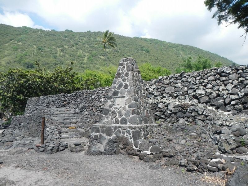
Near Puuhonua Road near Lower Nåpo'opo'o Road, on the right when traveling north.
In this heiau
January-28-1779
Captain James Cook, R.N.
Read the English
Burial Service over
William Whitman, Seaman
the first recorded
Christian service
in the Hawaiian Islands — — Map (db m110794) HM
Marker panel on obelisk (1874): In Memory of the great circumnavigator
Captain James Cook, R.N. who discovered these islands on the 18th of January, 1770 and fell near this spot on the 14th of February, 1779. . . . — — Map (db m72497) HM
This ancient Hawaii Sanctuary (Puuhonua) was preserved through the foresight of Charles R. Bishop who added it to the Bishop Estate. With the cooperation of the State of Hawaii, the trustees of the Bernice Pauahi Bishop Estate have dedicated it to . . . — — Map (db m2981) HM
The sanctuary lies within the shallow, warm waters surrounding the main Hawaiian Islands and is one of the world’s most important humpback whale habitats. Most of the North Pacific humpback whale population migrates nearly 3,000 miles to Hawaiian . . . — — Map (db m72000)
Near Kaahumanu Place near Palani Road, on the left when traveling north.
Upon this paepae (stone platform) is a representation of Ahu;ena Heiau. Restored by Kamehameha I upon the unification of the pae'aina (island chain), he rededicated Ahu'ena to Lono, the god of peace and prosperity. The Hale O Lono (House of Lono) . . . — — Map (db m110669) HM
Near Kaupulehu Drive near Aina Kaha Place, on the right when traveling north.
You are walking along a segment of the ala loa (long path), a Hawaiian foot trail that linked settlement areas along the coast from Kealakekua to Kawaihae. This segment of the trail was also identified as a traditional route for the huaka'i pō, . . . — — Map (db m110501) HM
This trail cuts across Kaloko-Honokohau National Historical Park, passing sites that represent many of the values for which this park was created, such as a malama ka aina, caring for the land. This was a place where Hawaiian families lived, values . . . — — Map (db m72001) HM
Near Kaleiopapa Street 1 mile north of Alii Highway, on the right when traveling north. Reported permanently removed.
Kauikeaouli was born within this enclosure March 17, 1814 the second son of Kamehameha I and Keopuolani. His reign (1825-1854) was the longest in the history of the Kingdom. While a minor, his kingdom knew the firm regency of Queen Ka'ahumanu, . . . — — Map (db m172848) HM
Kaloko-Honokohau National Historical Park celebrates the indigenous people of Hawaii. It penetrates deep into Hawaiian antiquity by preserving evidence of a thousand years of society. It links the touched with the heartfelt, transcending the . . . — — Map (db m71999) HM
Near Kaupulehu Drive near Aina Kaha Place, on the right when traveling north.
This archaeological site contains several residential and food storage features, and was first occupied on a temporary basis during the early 1800s. Fishing and collecting marine resources was the primary economic activity for residents of this . . . — — Map (db m110504) HM
Near Kaupulehu Drive near Aina Kaha Place, on the right when traveling north.
This is a portion of an ala loa (long path) or ala kahakai (a more recent term meaning trail by the sea) that follows the coastline. The Hawaiians of old used it to connect communities for socializing and exchanging goods, as well as to arrive at . . . — — Map (db m110506) HM
On Kealakehe Parkway, on the right when traveling west.
Honokohau Settlement has been designated a Registered National Historic Landmark under the provisions of the Historic Sites Act of August 21, 1935. This site possesses exceptional value in commemorating and illustrating the history of the United . . . — — Map (db m4248) HM
Near Kupipi Street 0.1 miles north of Keahole Airport Road, on the right when traveling south.
These three dancers convey the grace and power of Hula Kahiko, the ancient dance of Hawai'i. The flow of their skirts and the harmony of their movements capture the rhythm of the dance which highlighted many sacred and ceremonial occasions. Just . . . — — Map (db m190119) HM
On Alii Drive north of Hualalai Road, on the right when traveling south.
Hulihe‘e Palace was built in 1838 by Governor John Adams Kuakini, a companion of Kamehahena I and one of the first Chiefs to take up western ways. Built of coral lava rock and a native woods, it was handsomely furnished. Hulihe'e became the . . . — — Map (db m302) HM
On Alii Drive at Sarona Road, on the right when traveling north on Alii Drive.
Hulihe‘e Palace
Construction of Hulihe‘e Palace was completed in 1838. Hulihe‘e was the gracious residence of Governor John Adams Kuakini and a favorite retreat for Hawai‘i’s royal families. Kuakini oversaw the construction of both . . . — — Map (db m39424) HM
Near Kaupulehu Drive near Aina Kaha Place, on the left when traveling north.
In the shallow water flat of Ka'ūpūlehu Beach a special fishing technique was used by Hawaiians during rough water conditions. Stone piles (imu) were constructed as shelters to attract fish. These piles were then dismantled as nets were . . . — — Map (db m110582) HM
Near Palani Road near Kaahumanu Place, on the left when traveling north.
Home of Kamehameha I, founder of the Hawaiian Kingdom, from 1812 until his death. Here he built his residence, storehouses and fishponds and remodeled 'Ahu'ena Heiau, a temple of great antiquity. When he died here May 8 1819, his son Liholiho was . . . — — Map (db m110592) HM
On Kaahumanu Place near Palani Road, on the left when traveling north.
Kamakahonu
After uniting the Hawaiian kingdom, Kamehameha I returned to rule from his compound at Kamakahonu (lit. eye of the turtle) from 1812 until his death in 1819. 'Ahu'ena Heiau, the religious temple that served Kamehameha was rebuilt . . . — — Map (db m110665) HM
Near Alii Drive near Kahikina Lane, on the left when traveling north.
This sacred pond was built with lava rock and coral mortar in the mid 1800's. It once served as a bathhouse for the royal families. Fresh water empties into Ki’ ope pond through underground springs along the edges of the wall. Because of its rich . . . — — Map (db m123291) HM
On Ali'i Drive near Makolea Street, on the right when traveling south.
In the past, Hawaiian religious practices included the worship of many gods, both through individual and family rituals at small shrines and through larger community ceremonies at heiau (temples) such as this one. In 1819, King Kamehameha II . . . — — Map (db m110675) HM
Near Kaupulehu Drive near Aina Kaha Place, on the left when traveling north.
This projection of land, more properly known by an older name, Kumukea Point, is a significant landmark of coastal Kekaha. The surface 'a'ā lava that covers this area is the result of the historic Ka'ūpūlehu Flow of 1801, which was . . . — — Map (db m110507) HM
A prime habitat for kupe'e (Nerita polita) is located in a wave washed area of sand and basalt boulders along Ka'ūpūlehu Beach. This area is traditionally recognized for its dense concentration of kupe'e. These shellfish were collected . . . — — Map (db m110583) HM
Near Ali'i Drive 0.1 miles south of Hualalai Road, on the left when traveling north.
When the first Polynesians landed in Hawai‘i, most of the life they found here was unique to this place. Organisms found only in one place are called endemic — and Hawai‘i has one of the highest rates of endemism on the planet.
The first . . . — — Map (db m123294) HM
On Ali'i Drive near Liana Lane, on the left when traveling north.
Niumalu Beach
Once a hub for canoeing, water gathering and some shipping, the fancy beach at Niumalu (lit. shade of the coconut tree), commonly known as Kanuha Beach, is sheltered by a sea wall that has protected beach-goers of over 100 . . . — — Map (db m110586) HM
Approximately 500 feet (150 meters) offshore of this location is a ko'a moi. Moi is Hawaiian for Treadfin (Polydactlus sexfilis), and ko'a is a fishing ground. This fishing spot was prized for its abundance of moi, which traditionally was a highly . . . — — Map (db m110585) HM
On Alii Drive at Sarona Road, on the right when traveling north on Alii Drive.
The first Hawaiian Christian,
Henry Opukahaia,
died at Cornwall, Conn. 1818
The first Christian
missionaries to Hawaii,
Bingham, Thurston, Whitney,
landed at Kailua, April 12, 1820
with their Hawaiian comrades
Hopu, . . . — — Map (db m39440) HM
Near Kupipi Street 0.4 miles north of Keahole Airport Road, on the right when traveling south.
In Hawai'i, the lei, a garland of flowers, coveys respect, love, friendship, and continuity of life. It may be created from a wide variety of local flora and is offered on many occasions calling for a special token. The giving of leis as a floral . . . — — Map (db m190121) HM
On Kaupulehu Drive near Aina Kaha Place, on the left when traveling north.
By virtue of being a named place, Waiulu was clearly known by the people of old. It is a place of note recounted by elders in the area. A hālau wa'a (canoe house) was located here, indicating a good landing. One of the important factors that . . . — — Map (db m110502) HM
Near Kaupulehu Drive near Aina Kaha Place, on the left when traveling north.
Despite the naturally arid conditions of the surrounding landscape, there a few sources of drinkable water within this part of coastal Kekaha. One of these is located a short distance inland from this location. It is known as Waiulu, which is . . . — — Map (db m110503) HM
On Akoni Pule Highway (Hawaii Route 279) at Kapaau Road, on the right when traveling east on Akoni Pule Highway.
To the
100/442nd Infantry Regiment
With Deep Sincerity and Upmost Appreciation for
The Gallant Fight to Effect Our Rescue After
We Had Been Isolated for Seven Days
1st BN., 141st Infantry Regiment
Biffontaine, France
From . . . — — Map (db m110328) WM
A heiau (temple) at Pu’ukohola was built long before Kamehameha started construction on the heiau that you see. This showed great vision and strategy on the part of the kahuna (priests). The heiau was physically very prominent and imposing on the . . . — — Map (db m71886) HM
Welcome to Pu’ukohola Heiau, one of the most famous heiau (temples) in the Hawaiian Islands. This heiau is an integral component of the traditional Hawaiian social, political, and religious systems, and a significant place in the history of King . . . — — Map (db m71874) HM
Near Mamalahoa Highway (Hawaii Route 11) 0.1 miles north of Konawaena School Road, on the left when traveling north.
Greenwell Store
circa 1875
Has been placed on the
National Register
of Historic Places
by the United States
Department of the Interior
Kona Heritage Store
Greenwell Store
est. ca. 1875
Kona Historical Society & . . . — — Map (db m123293) HM
First Church in the Islands
this building erected in 1836
model of brig "Thaddeus"
on exhibit. Open Daily from
dawn to dusk. Komo mai — — Map (db m190118) HM
Near Waikoloa Beach Drive near Ku'uali'i Place, on the right when traveling north.
Kamehameha ("The Lonely One") the Great was born in Hohala on the island of Hawai'i. Uniting all the major islands under one rule in 1810, he established himself as a fierce warrior, and wise and compassionate leader to his people. — — Map (db m108954) HM
Near Waikoloa Beach Drive near Ku'uali'i Place, on the right when traveling north.
Liholiho ascended the throne at a time when foreign influences, and new standards and ideas were propelling the Hawaiians into the modern western world. During his reign, the kapu system was abolished and the missionaries arrived, brining . . . — — Map (db m108956) HM
Kauikeaouli was a strong leader and contributed the greatest number of reforms during his 30 year reign, the longest in the history of Hawai'i. His mild manner, good judgement, and solid character made him a King loved and greatly respected by his . . . — — Map (db m108951) HM
Near Waikoloa Beach Drive near Ku'uali'i Place, on the right when traveling north.
Alexander Liholiho, grandson of Kamehameha the Great, brought a great appreciation for etiquette and ceremony to court. He and his wife Emma Rooke showed great concern for the welfare of their people and established the Queen's Hospital . . . — — Map (db m108952) HM
Lot Kamehameha favored a stronger monarchy and placed much of the power back into the hands of royalty. He was the last ruler to bear the name of the great conqueror and was credited with many public improvements and acquisition of much land. . . . — — Map (db m108957) HM
On Holoholokai Beach Park Road, on the right when traveling west.
Man has always left his mark. Symbols in rock were left by many early civilizations. Te Puako Petroglyph site is one of the largest and finest concentrations of the mysterious symbols left in Hawai‘i. It is likely that many of these petroglyphs . . . — — Map (db m3029) HM
Near Waikoloa Beach Drive near Ku'uali'i Place, on the right when traveling north.
The grandson of a half-brother of Kamehameha the Great, he became the first king to be elected. Well-educated, Lunalilo was very popular with the people and became the first Hawaiian to leave his property to charity. — — Map (db m108964) HM
On Waikoloa Beach Drive at Maintenance Road, on the right when traveling west on Waikoloa Beach Drive.
Much of the Ala Loa trail was built over an ancient foot trail which can still be seen here as it meanders beside the new trail. The section of the trail on the Kaniku lava flow remains intact and will be preserved. The trail was probably used . . . — — Map (db m110403) HM
Near Waikoloa Beach Drive near Pohakulana Place, on the right when traveling east.
Chiefs of highest rank and sacred wife of Kamehameha I married in 1791. Mother of Kamehameha II, Kamehameha III and Princess Nāhi'ena;ena. Keōpūolani's extremely high-ranking ali'i (royalty) status prohibited people from looking at . . . — — Map (db m110408) HM
Near Waikoloa Beach Drive near Pohakulana Place, on the right when traveling east.
Born of ali'i (royalty) lineage, Ka'ahumanu married Kamehameha I as a young girl and became his favorite wife. When he died in 1819, she was named Kuhina Nui (Prime Minister) alongside young King Liholiho Kamehameha II. A powerful influence, she . . . — — Map (db m110407) HM
Near Waikoloa Beach Drive near Pohakulana Place, on the right when traveling east.
Of high lineage she was a logical match for the highest born ali'i (royalty) of her generation. Courted by many, she was betrothed to her cousin King Kamehameha V. In 1848 Kamehameha V chose Pauahi as his successor to become queen. She declined the . . . — — Map (db m110419) HM
Near Waikoloa Beach Drive near Pohakulana Place, on the left when traveling east.
Emmalani Na'ea Rooke Kaleleonalani was grand-niece of Kamehameha I and granddaughter of John Young, his royal advisor. She and husband Kamehameha IV had one son, Prince Albert, who died at the age of 4, followed not long after by his father. . . . — — Map (db m110412) HM
Near Waikoloa Beach Drive near Pohakulana Place, on the right when traveling east.
Kalama Hakaleleponi Kapakuhaili was the daughter of ali'i (royalty) Kaihekukui and Iahu'ula. She married Kauikeaouli Kamehameha III, who introduced the division and disbursement of traditional lands known as the "Great Mahele." A very well-educated . . . — — Map (db m110410) HM
Near Waikoloa Beach Drive near Pohakulana Place, on the right when traveling east.
Ester Julia Kapiolani, granddaughter of Kaumuali'i, the last King of Kaua'i. Widow of Namakaeha, married King David Kalākaua in 1863 and as a gift he built Kapi'olani Park in Waikīkī in her honor. Deeply concerned about the moribund . . . — — Map (db m110418) HM
Near Waikoloa Beach Drive near Pohakulana Place, on the right when traveling east.
Lydia Liliuokalani Kamaka'eha Paki Dominis sister of Kalakaua, adopted by Paki and Konia, married John O. Dominis. Declared heir apparent on April, 11, 1877 following the death of her brother Prince Leleiohoku II. Ascended to the throne on January . . . — — Map (db m110420) HM
Also known as Tamehamalu, Victoria Kamāmalu was the daughter of Kamehameha I and married Liholiho Kamehameha II. Only 5 years after he took the throne, the King and Queen sailed to London for a state visit with King George IV. While in England, . . . — — Map (db m110409) HM
On King's Trail, on the right when traveling north.
Before you lies one of the major concentrations of ancient rock carvings in the Hawaiian Islands. Boundaries were not crossed casually in old Hawaii, and the thousands of surface carvings here, just north of the border between the ancient . . . — — Map (db m4247) HM
On Mamalahoa Highway (Hawaii Route 190) at Pu'uopelu Road, on the right when traveling west on Mamalahoa Highway.
Four stones make up this monument:
The 2nd and 5th Marine Divisions
trained here to bring peace
to the Pacific
Parker Ranch & Camp Tarawa 1943-1945
This monument honors the V Amphibious Corps (VAC), and . . . — — Map (db m108940) HM WM
Near Akoni Pule Highway (Hawaii Route 270), on the left when traveling north.
Archaeologists seek to understand people and places of the past by studying the sites and cultural remains left behind. Students from the University of Hawai'i conducted extensive excavations here between 1968 and 1970 to learn about the people of . . . — — Map (db m110325) HM
Near Akoni Pule Highway (Hawaii Route 270), on the left when traveling north.
The ahupua'a is a traditional land division that runs mauka from the mountains to makai (seaward). The ahupua'a of Lapakahi encompasses more than 2,000 acres along the leeward slopes of the Kohala Mountains. The distance from the upland forests . . . — — Map (db m110324) HM
Near Kawaihae Road near Kawaihae Harbor Road, on the left when traveling north.
The submerged remains of Hale o Kapuni Heiau, a temple dedicated to shark akua (deities), are believed to lie just offshore. The heiau was built by a chief whose family revered sharks, believing that the family's 'aumākua (deified ancestors) . . . — — Map (db m110377) HM
On Daniel K. Inouye Highway (Saddle Road) (Route 200 at milepost 27) near Mauna Kea Access Road, on the left when traveling east.
Traditional native uses of the Humu'ula area included bird catching and, at much higher elevations, adze quarrying. They were replaced by sandalwood harvesting and hunting wild cattle, and ultimately ranching and astronomy. Over time, travelers . . . — — Map (db m110792) HM
On Daniel K. Inouye Highway (Saddle Road) (Hawaii Route 200 at milepost 28) at Mauna Kea Access Road, on the right when traveling east on Daniel K. Inouye Highway (Saddle Road).
Sheep raising became economically important within the interior of Hawai'i during the second half of the nineteenth century. In the 1860s, the Waimea Grazing and Agricultural Company established a station for sheep at Humu'ula. By 1873 it had a . . . — — Map (db m110787) HM
Near Kawaihae Road (Hawaii Route 270), on the left when traveling north.
The remains of Mailekini Heiau, a temple used before the time of Kamehameha, stand before you. Many mysteries surround Mailekini Heiau; its early history, kept orally and secretly within the priesthood, was never recorded. Historians agree that . . . — — Map (db m110367) HM
Near Kawaihae Road (Route 270), on the left when traveling north.
Who would suspect that the area at the base of this hill is one of the most significant cultural sites in Hawai'i? This plain-looking patch of earth was the site of Pelekane, one of several known royal compounds traditionally used by Hawaiian kings. . . . — — Map (db m110369) HM
On Daniel K. Inouye Highway (Saddle Road) (Route 200 at milepost 28) at Mauna Kea Access Road, on the right when traveling east on Daniel K. Inouye Highway (Saddle Road).
What is a kīpuka?
Pu'uhuluhulu, a 500-year old patter cone, is a kīpuka ( an older oasis within a newer lava flow). It preserves native plants and acts as a seed bank to revegetate the more recent lava flows that surround it. . . . — — Map (db m110790) HM
Near Kawaihae Road near Kawaihae Harbor ( Route 270), on the left when traveling north.
Build a heiau on Pu'ukoholā, the "hill of the whale," dedicate it to your war god, and you will achieve your dream - you will rule the islands. Responding to this prophecy told by Kapoykahi, a famous seer, Kamehameha built the . . . — — Map (db m110330) HM
On Mamalahoa Highway (Hawaii Route 19) near Lindsey Road, on the left when traveling west.
With the first cattle arriving in the Hawaiian Islands in 1793 as gifts for King Kamehameha I, it was not long before they overpopulated and plundered the countryside from the mountains to the seashores. Determined to bring them under control and . . . — — Map (db m108949) HM