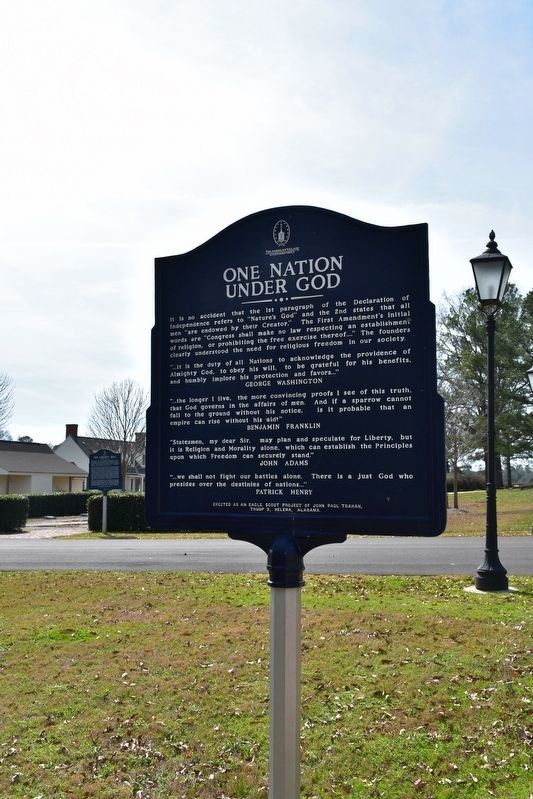
Near Montevallo Road (Alabama Route 119) 0.3 miles south of Alex Mill Road, on the right when traveling south.
The Lucille Ryals Thompson Colonial Chapel
Inspired by Bruton Parish Church of Williamsburg, Virginia, it was named to honor Lucille Ryals Thompson. The Chapel was built in thanksgiving for God’s blessings on America, and to honor the gift . . . — — Map (db m101505) HM
Near El Camino Real near Mercedes Avenue (California Route 41), on the right when traveling north.
The purpose of this monument is to forever stand as a tribute to our nation's Founding Fathers who created the two most important documents that laid the foundation of our country: the Declaration of Independence and the U.S. Constitution. This . . . — — Map (db m67581) HM
On Main Street at Ferry Lane, on the left when traveling north on Main Street.
The first ferry crossing of the Connecticut River was tended by John Bissell in 1641. This road leads to the landing place where succeeding generations of Bissells, and finally the Town, kept this Ferry in continuous operation until 1917. Main . . . — — Map (db m114003) HM
On River Road (Connecticut Route 32) near Main Street, on the right when traveling north.
This is the home of the famous mineral springs where the Indians met to drink the iron and sulphur waters to make them “lively” and to which the future President John Adams came for his health in 1771. Later the elite of the Nation gathered here for . . . — — Map (db m111917) HM
On East Town Street at Town Street, on the right when traveling north on East Town Street.
English settlers in southeastern Connecticut aided the Mohegan Tribe many times during the 17th century Pequot and Narragansett Wars. In 1645 Thomas Leffingwell and others helped lift a Narragansett siege of the Mohegans' Fort Shantok on the . . . — — Map (db m268167) HM
German-Americans Fight for Independence
John Adams’ letter of 6 July 1775 to James Warren provides a most vivid image of one of thousands of German-Americans willing and anxious to fight for American independence: A . . . — — Map (db m154644) HM
Near Gales Street Northeast west of 18th Street Northeast, on the right when traveling east.
The White House is where every president of the United States since John Adams has lived. But it is more than just a home for presidents and their families. The White House also has offices, including one for the president called the Oval Office. . . . — — Map (db m315963) HM
On Newark Street Northwest at 35th Street Northwest, on the right when traveling west on Newark Street Northwest.
The Rosedale farmhouse is said to be the oldest house surviving in Washington, DC. It was named to the National Register of Historic Places in 1973.
The farmhouse is a private home.
Please do not enter farmhouse grounds.
. . . — — Map (db m112385) HM
On Wisconsin Avenue Northwest at M Street Northwest, on the left when traveling north on Wisconsin Avenue Northwest.
You are standing at what has been the crossroads of Georgetown since Colonial times. George Town was laid out on the bluffs above the harbor on either side of Wisconsin Avenue. The avenue then was called Frederick Town Rolling Road because it was . . . — — Map (db m113647) HM
Near Old North Way Northwest north of Library Walk Northwest, on the right when traveling north.
Old North was the University's main building from 1795 until the completion of the Healy building in 1879. During this period, it was not uncommon for the President of the United States to visit the University for commencement exercises, or for . . . — — Map (db m255242) HM
On Constitution Avenue Northwest (Alternate U.S. 1) west of 4th Street Northwest, on the right when traveling west.
A bronze likeness of Chief Justice John Marshall, visible on your way to the next Heritage Trail sign, keeps watch over John Marshall Park to your right. Marshall is remembered for molding the U.S. Supreme Court into today's authoritative body. . . . — — Map (db m56495) HM
On Pennsylvania Avenue Northwest (Alternate U.S. 1) at 4th Street Northwest, on the right when traveling west on Pennsylvania Avenue Northwest.
Site of the residence of John Marshall Chief Justice of the United States Plaque erected under the auspices of the Columbia Historical Society and the Bar Association of the District of Columbia.
[Inscription on wall below the marker . . . — — Map (db m58625) HM
Near Constitution Avenue Northwest (U.S. 50) east of 19th Street Northwest, on the right when traveling east.
In Congress, July 4, 1776.Unanimous Declaration of the thirteen united States of America.And for the support of this Declaration,
with a firm reliance on the protection of Divine Providence,
we . . . — — Map (db m137039) HM
On Pennsylvania Avenue Southeast east of 7th Street Southeast, on the right when traveling east.
America’s oldest navy and marine installations are just blocks from where you are standing.
This is the northern edge of a Capitol Hill community shaped by the presence of the U.S. military. Eighth Street is its commercial center. The . . . — — Map (db m130729) HM
On 8th Street Southeast at I Street Southeast, on the right when traveling south on 8th Street Southeast.
If you are hearing the ringing tones of band music, one of the ensembles of the world-famous United States Marine Band may be practicing inside the Marine Barracks.
John Philip Sousa, the neighborhood’s most famous son, spent 19 years . . . — — Map (db m130738) HM
On Dahlgren Avenue Southeast south of Kidder Breese Street Southeast, on the left when traveling south.
The Navy Department Library was established by President Adams on 31 March 1800. On that date he wrote to the first Secretary of the Navy, Benjamin Stoddart, requesting the gathering
“… of all the best writing in Dutch, Spanish, French, . . . — — Map (db m51068) HM
In 1766 Richard Oswald acquired 20,000 acres of land along the Halifax and Tomoka rivers from the British government. On this grant was established Mount Oswald Plantation which was located on this site, and produced indigo, rice, timber, molasses, . . . — — Map (db m21331) HM
(Panel one)
British Military Force Threatens the United States In the early years of the 19th century, the United States was a fledgling nation with
a population of 7,700,000, a standing army
of 6,700, and a navy of only 12 ships. . . . — — Map (db m25014) HM
"This is no time to talk of moderation; in the
present instance it ceases to be a virtue."
Speech to Provincial Congress, June 5, 1776 Foremost among Georgia's Revolutionary patriots stood Archibald Bulloch whose remains rest in this . . . — — Map (db m5335) HM
On Hollywood Highway (Old U.S. 441) 0.1 miles north of New Liberty Road, on the left when traveling north.
This was the summer home of Joseph Habersham of Savannah (1751-1815), Georgia patriot, Revolutionary War hero, and political leader. He was a Colonel in the Continental Army, a member of Continental Congress, and of the Georgia Convention that . . . — — Map (db m43697) HM
Near School Street east of Center Avenue, on the right when traveling east.
A few thoughts about democracy:
Democracy is "government of the people, by the people, for the people"
-Abraham Lincoln
"Man's capacity for justice makes democracy possible, but man's inclination to injustice makes democracy . . . — — Map (db m304936) HM
On Main Street at Wesley Street, on the right when traveling north on Main Street.
The original homestead of John Quincy Adams was located in the center of this block. The home was built in the late 1800s and demolished in January, 1943. John Quincy Adams was a descent of the second and sixth presidents of the United States. The . . . — — Map (db m284805) HM
On Tavernier Way 0.2 miles south of West MacArthur Drive (Illinois Route 111/140), on the left when traveling south.
Theodore Roosevelt Letter On Cuba
On January 22, 1907, President Theodore Roosevelt wrote to Secretary of War William Howard Taft rejecting the idea of a protectorate over Cuba and expressing his determination that the United States should . . . — — Map (db m169581) HM
Miami Chief Mishikinakwa or Me-she-kin-no-quah, known to the Euro-Americans as Little Turtle, born circa 1747, played a significant role in the settlement of the area surrounding the confluence of the Three Rivers. He was the most successful Native . . . — — Map (db m197057) HM
On Lawton Place 0.1 miles east of Spy Run Avenue, on the right when traveling east.
Chief Little Turtle was one of the most feared and respected leaders during the frontier wars of the 1780s and 1790s when Fort Wayne was born. Known to his people as Meshekinnoquah, Little Turtle is thought to have been born in 1752 in a village . . . — — Map (db m21503) HM
On Park Street east of East Scott Street, on the right when traveling east.
On July 4, 1800, the western part of the
Northwest Territory became the Indiana Territory.
It covered land that would eventually be included
in the present states of Indiana, Illinois, Michigan,
Wisconsin, and Minnesota.
Vincennes, on the . . . — — Map (db m23266) HM
On Prince George Street west of Craig Street, on the right when traveling west.
February 22, 1797: At the Presidential Mansion in Philadelphia, President George Washington formally presented Irish-born John Barry with Commission Number One in the newly formed United States Navy. With the commission, backdated to the . . . — — Map (db m114812) HM
On West Street (Maryland Route 450) west of Church Circle, on the right when traveling west.
1784
Peace Treaty Ratified[Captions:]
• Governor William Paca's Proclamation of the ratification of the Treaty of Paris. Treaty of Paris Broadside Collection [MSA SC 5785]
• The last page of the Treaty of Paris, . . . — — Map (db m114555) HM
On East Patapsco Avenue (Maryland Route 173) just east of 2nd Street ( Route 686), on the right when traveling west.
Dedicated in reverent tribute to those patriots from the Brooklyn, Curtis Bay, Fairfield area who gloriously served our beloved America in her tragic wars.
"Posterity! You will never know how much it cost the present . . . — — Map (db m212964) WM
Near Washington Boulevard, on the right when traveling south.
In the late 1760’s, the Mount Clare mansion was built by Charles Carroll, Barrister and his wife, Margaret Tilghman, as their summer home. The mansion was located on the grounds of the original plantation, Georgia, and included an orangery, . . . — — Map (db m2533) HM
Near Constellation Plaza 0.1 miles east of Wallace Street, on the right when traveling east.
"This tree dedicated to Colonel James McHenry Secretary of War under Presidents Washington and John Adams and for whom Fort McHenry was named in 1798 when it was offered to the Federal Government." — — Map (db m145548) HM
On Toledo Road just west of America Boulevard, on the left when traveling west.
The Declaration of Independence
On June 7, 1776, forty-four-year-old Richard Henry Lee, Senior Member of the Virginia Delegation, submitted a resolution to the Continental Congress:
Resolved, that these United Colonies . . . — — Map (db m145903) HM
On Main St (Massachusetts Route 6A) 0.1 miles east of Railroad Ave, on the right when traveling east.
James Otis Jr.
The Patriot
West Barnstable
1725 — 1783
Advocate Orator Statesman
President John Adams Said In Part
Of Otis’s Famous Writs Of Assistance
Speech In Boston February 1761
“American Independence . . . — — Map (db m142330) HM
On Rockwell Road 8 miles north of Quarry Road, on the right when traveling north.
Adams Overlook: A Town Tied to the Mountain
Mount Greylock State Reservation
Adams Overlook faces east, looking over the town of Adams to the Hoosac Range, a branch of the Berkshire Mountains. Named after Revolutionary War hero John . . . — — Map (db m85154) HM
On Hancock Street at Washington Street, on the left when traveling south on Hancock Street.
“Improve your understanding for acquiring useful knowledge and virtue, such as will render you an ornament to society, an Honour to your Country, and a Blessing to Your parents.” Abigail Adams in a letter to her . . . — — Map (db m299843) HM
On Burgin Pkwy at Dimmock Street, on the right when traveling north on Burgin Pkwy.
Farmer Lawyer Patriot Diplomat First Vice President Second President of the United States Side of Monument: There is danger from all men. The only maxim of a free government ought to be to trust no man living with power to endanger the public . . . — — Map (db m18052) HM
On Adams Street, on the right when traveling west.
National Park Service U.S. Department of the Interior [ Back of marker ] “It is but the farm of a Patriot” • • • • • John Adams, 1788 — — Map (db m40652) HM
On Franklin Street north of Presidents Avenue, on the left when traveling north.
John Adams was born in 1735 in the house at the rear of the lot. John Quincy Adams was born in 1767 in the house at today's street corner. Here, Abigail Adams managed house and farm for several years during the Revolution. Here, John Adams drafted . . . — — Map (db m299842) HM
On Hancock Street at Washington Street, on the left when traveling south on Hancock Street.
Within this church are the tombs of two Presidents of the United States and their wives John Adams – Second President 1735 1826 Abigail Adams 1744 1818 their son John Quincy Adams – Sixth President 1767 1848 Louisa Catherine Adams 1775 . . . — — Map (db m18051) HM
On Monument Square at Monument Ave. on Monument Square.
Neighborhood of Revolution “Paul Revere . . . started on a ride which, in a way has never ended.” - Esther Forbes, author of the classic study, Paul Revere and the World He Lived In In the course of just two pivotal days – April 18 and . . . — — Map (db m191830) HM
On Tremont Street at Bromfield Street, on the left when traveling north on Tremont Street. Reported missing.
From 1769-1776 Boston was the flashpoint for events leading up to the American Revolution. On February 22, 1770, a crowd gathered around the house and shop of a Tory sympathizer and customs agent, Ebenezer Richardson. When they started pelting the . . . — — Map (db m18766) HM
On Washington Street at Milk Street, on the right when traveling north on Washington Street.
Her husband's closest political advisor, Abigail Adams is one of the clearest thinkers in colonial Boston. While she is unable to wield political power herself due to her gender and the norms of the eighteenth century, she persists nonetheless in . . . — — Map (db m316439) HM
On Washington Street at Milk Street, on the right when traveling north on Washington Street.
A lawyer and civic leader, John Adams always does what he thinks is right. If it gets him into trouble, so be it! And if it raises his profile, all the better! He defended the soldiers in the Boston Massacre case and publicly supported the colonists . . . — — Map (db m316436) HM
On Devonshire Street at State Street, on the left when traveling north on Devonshire Street.
Neighborhood of Revolution “Paul Revere . . . started on a ride which, in a way has never ended.” - Esther Forbes, author of the classic study, Paul Revere and the World He Lived In In the course of just two pivotal days – April 18 and . . . — — Map (db m191828) HM
Near Tremont Street at Bromfield Street, on the left when traveling north. Reported missing.
Three hundred years ago this location did not have ideal conditions for a graveyard. There were many underground springs which made it soggy and damp. Tomb owners routinely found their tombs filled with water, with caskets and bodies floating about. . . . — — Map (db m18770) HM
The Salutation Tavern Opened in 1662, stood on the north east corner of Salutation and North Streets adjoining this Mall It was the meeting place of The Committee of Safety and in it was planned The Boston Tea Party Here Samuel . . . — — Map (db m76625) HM
On 23rd Avenue at Iron Street, on the left when traveling east on 23rd Avenue.
War
Since recorded history, one of the tragedies of man's existence is war. Wars are started by leaders and finished by citizens of the country they represent - and always at a terrible cost in human lives.
These memorials will help you . . . — — Map (db m73566) WM
Author of the Declaration of Independence and the Statute of Virginia for Religious Freedom, third president of the United States and founder of the University of Virginia - voiced the aspirations of a new America as no other individual of his . . . — — Map (db m179400) HM
Near Hessian Road, on the right when traveling west.
“Ye English soldiers came . . . They took two mares from me . . . and while the army was passing they came in and took our bread, pie, milk, cheese, meat dishes, cups, spoons, and then took shirts, sheets, blankets, coverleds, stodking, . . . — — Map (db m89743) HM
Near Nassau Street, on the right when traveling east.
Preacher “One of the most useful qualifications of a good minister is that he have a lively sense of religion upon his own heart.” John Witherspoon Born in Gifford, Scotland, in 1723, Witherspoon was educated at the . . . — — Map (db m44842) HM
1790 — Trenton named capital of New Jersey.
John Fitch’s steamboat makes Trenton–Philadelphia trips three days a week.
1792 — State House opens.
Assembly meets in State House for first time.
1799 — President . . . — — Map (db m3985) HM
Following the Treaty of Paris in 1783, the newly independent United States were faced with establishing a national capital. Up to this point the Continental Congress had met in several places, most often in Philadelphia and New York City. Congress . . . — — Map (db m166108) HM
On Albany Street (New Jersey Route 27) at Burnet Street ( Route 18), on the right when traveling west on Albany Street.
Settlement begun about 1680 by Dutch and English received from George II city charter as New Brunswick in 1730. This highway was an Indian trail to the falls of the Delaware and the Minisink Trail to Navesink crossed it here. It became the Great . . . — — Map (db m62691) HM
On Water Street, on the left when traveling south.
This piece of land has always been called the Bluff, meaning a hill with a broad, steep face. This site’s history suggests another meaning for bluff – to hoodwink. It was here that a delaying tactic permitted an escape, that a fugitive found . . . — — Map (db m25112) HM
Near Satterlee Street, on the left when traveling north.
Built by and for Christopher Billopp about 1680, this house was long a center of colonial hospitality. It is known also as “Conference House” because Benjamin Franklin, John Adams and Edward Rutledge met here with Lord Howe at his request on . . . — — Map (db m287877) HM
On Satterlee Street, on the left when traveling north.
In September 1776, Benjamin Franklin, John Adams, and Edward Rutledge met here with British Lord Howe in an unsuccessful negotiation for peace. — — Map (db m8727) HM
Near Satterlee Street, on the left when traveling north.
< Lower Plaque: >
Long known as “The Billopp House” built before 1700 In this house on September 11, 1776 after the Battle of Long Island a Peace Conference was held between Lord Howe, Benjamin Franklin, John Adams, and Edward . . . — — Map (db m7889) HM
On Guilford Courthouse Auto Tour Road at Old Battleground Road, on the left when traveling west on Guilford Courthouse Auto Tour Road.
In Memoriam William Hooper and John Penn delegates from North Carolina 1776 to the Continental Congress and signers of the Declaration of Independence. Their remains were reinterred here 1894. Hewes’ grave is lost. He was the third signer. . . . — — Map (db m34883) HM
On 2nd Street (U.S. 52) west of Jack Roush Way, on the right when traveling west.
Israel Donalson, member of the First Constitutional Convention of Ohio.
In May 1800, Congress passed an act building the Northwest
Territory, with the western division becoming Indiana
Territory and the eastern called the Territory of the . . . — — Map (db m136539) HM
On Main Street (U.S. 36) at Plum Street, on the right when traveling west on Main Street.
Served in the Continental Army under the command of General Washington. Appointed as Accountant of the War Department by Washington and served under Presidents Adams, Jefferson and Madison. For his services in the Continental Army, received a land . . . — — Map (db m227846) HM
On Main Street (U.S. 36) at Bridge street (Ohio Route 60), on the left when traveling west on Main Street.
In 1800, President John Adams granted 4,000 acres in the Walhonding Valley to William Simmons for his service to the United States of America as a Colonel during the Revolution, and for being one of five men appointed by President George Washington . . . — — Map (db m157850) HM
On Cliff Road 0.1 miles north of Bower Road, on the right when traveling north.
Life at North Bend
As the War of 1812 concluded, William Henry Harrison resigned his post, content to make public appearances and live a settled life with his family here in North Bend.
Though his presidential campaign would . . . — — Map (db m167277) HM
On Washington Street at Grant Ct., on the left when traveling west on Washington Street.
Governor Charles Willing Byrd
was the son of Colonel William Byrd of
Virginia. In 1792 President John Adams
appointed him secretary of the Northwest
Territory and in 1802 he became acting
governor of the territory. He was a
delegate to the . . . — — Map (db m121877) HM
[Left Historical Marker]:
This Land Office was established by Congress
on May 10, 1800.
President John Adams appointed David Hoge
as Land and Title Registrar, which position
he held for forty years.
In 1801 Mr. Hoge bought the . . . — — Map (db m46886) HM
On Coshocton Street (U.S. 62) at Woodgate Drive, on the right when traveling west on Coshocton Street.
Side A: Johnstown Cemetery
In 1810, Dr. Oliver Bigelow from Cayuga County, New York, purchased a 4,000-acre tract of land in Monroe Township from John Brown of Boone County, Kentucky, for the sum of $10,000. President John Adams had . . . — — Map (db m16711) HM
On Bainbridge Road at Avon-Beldon Road (Ohio Route 83), on the right when traveling east on Bainbridge Road.
U.S. Service Members: 217,000
Battle Deaths: 4,435
"Posterity! You will
never know how much
it cost the present
generation to preserve
your freedom! I hope
you will make a good
use of it. If you do not,
I shall repent in . . . — — Map (db m300411) WM
Labor leader, workers' advocate. Arrested and jailed in Homestead for speaking to striking steelworkers, 1919. When a judge asked who gave her a permit to speak publicly, she replied, "Patrick Henry. Thomas Jefferson. John Adams!" — — Map (db m44869) HM
[Chronology]
Revolutionary War · 1775-1783
April 19, 1775
"Shot Heard Around the World," the American Revolution begins
November 10, 1775
Continental Congress authorized the first two Continental Marine Battalions
March . . . — — Map (db m143969) HM WM
On Main Street at Broad Street (Pennsylvania Route 313), on the right when traveling south on Main Street.
Site of early challenge to federal government's authority. This armed resistance by Pennsylvania-German farmers to the 1798 federal house tax was suppressed by soldiers. Leader John Fries was arrested for treason, condemned to death, and pardoned . . . — — Map (db m26846) HM
Near West High Street (U.S. 11) at North West Street.
Entering this gateway to Dickinson College, you can see the statue of the college's founder, Dr. Benjamin Rush (1745-1813). The bronze statue, which was erected in 2004, is a replica of a statue unveiled 100 years earlier at the Navy's Bureau of . . . — — Map (db m82795) HM
On Queen Street at King Street, on the right when traveling north on Queen Street. Reported missing.
Indian wigwams, a hickory tree, and a spring - that was old center square "Hickory Town" prior to 1730. In that year, however, significant changes occurred as Andrew and James Hamilton laid out Lancaster Townstead with an open square. Streets . . . — — Map (db m5151) HM
On Main Street at Old York Road, on the left when traveling north on Main Street.
“They have carried the mechanical Arts to greater Perfection here than in any Place which I have seen.”
John Adams to Abigail Adams
April, 1777
Early Industrial History
By 1745, only four years after they founded Bethlehem (1741), . . . — — Map (db m26917) HM
“They have a Sett of Pumps which go by Water, which force the water up through leaden Pipes, from the River to the Top of the Hill, near an hundred feet.”
John Adams to Abigail Adams
1777
A bountiful spring supplied . . . — — Map (db m27191) HM
On Heckwelder Place, on the left when traveling south.
Before and during the American Revolution many noted patriots worshiped here, including George Washington, Martha Washington, Benjamin Franklin, John Adams, Samuel Adams, John Hancock, Count Casimir Pulaski and the Marquis de Lafayette.
In 1792 . . . — — Map (db m27189) HM
On South 6th Street (County Road 2005) at Market Street (County Road 2004), on the left when traveling south on South 6th Street.
Archeology
Archeology is the study of the past through the material remains of everyday objects that people lost or discarded in the places they inhabited and the spaces through which they moved. Wherever people live or work or play, they . . . — — Map (db m306966) HM
On South 6th Street (County Road 2005) at Market Street (County Road 2004), on the left when traveling south on South 6th Street.
Caught between his private doubts about slavery and his public responsibilities as president, George Washington navigated a nation deeply divided over slavery. Privately, George Washington often expressed discomfort with the institution and a . . . — — Map (db m306989) HM
On Frankford Avenue at Church Street, on the right when traveling north on Frankford Avenue.
Frankford
… this road was marked out in 1675 as
The King's Highway
and improved by the order of the Provincial Council in 1862.
William Penn traversed this road in going to his home of Pennsbury.
John Adams & other . . . — — Map (db m269620) HM
On Benjamin Franklin Parkway at Winter Street, on the right when traveling east on Benjamin Franklin Parkway.
Great soldier of freedom
who participated in the three greatest political upheavals of his time: the struggle for Independence in the United States, the French Revolution and the emancipation of Latin America.
On South 2nd Street just north of Walnut Street (County Road 3006), on the right when traveling south.
The elite of Philadelphia built this tavern to drink, dine, and dance—among their own.
Business and politics were on the menu and deals were often sealed with drinks. Delegates to the Continental Congress dined here, and in 1787, members of . . . — — Map (db m227599) HM
On Chestnut Street at 3rd Street, on the right when traveling east on Chestnut Street.
This bronze sculpture replicates John Trumbull’s famous painting Declaration of Independence that is displayed in the Rotunda of the United States Capitol. It depicts the presentation of the draft of the Declaration of Independence to the . . . — — Map (db m106148) HM
On North 4th Street at Arch Street on North 4th Street.
George Washington died on Dec. 14, 1799. Congress set Dec. 26 as a day of formal mourning in Philadelphia, the nation's capital from 1790 to 1800. The national funeral was in Zion Lutheran Church--located at this site, 1766-1870-- and among those . . . — — Map (db m43006) HM
On South 2nd Street close to Walnut Street, on the left when traveling north.
The City Tavern in Philadelphia was erected at a great expense by a voluntary subscription of the principal gentlemen of the city or the convenience of the public, and is much the largest and most elegant house occupied in that way . . . — — Map (db m51219) HM
Near Pine Street east of South 5th Street, on the right when traveling east.
Duffield's sermon urged citizens to "break free of Crown rule" Four months before the Declaration of Independence was signed, he preached a sermon to members of the Continental Congress and several militias urging them to support the cause of . . . — — Map (db m214054) HM
On 4th Street at St. James Place, on the right when traveling south on 4th Street.
Old St. Mary's church was the most important Catholic church during the American Revolution and the early years of the nation. Built in 1763, when St. Joseph's became too small to accommodate the Catholic population of the city, the church was . . . — — Map (db m9111) HM
On South 3rd Street 0.1 miles Spruce Street, on the left when traveling north.
He was the enemy of all exorbitants Powers and a sincere Friend to the Liberties of his Country. To all this was added a Taste for Science, for the Fine Arts and for all the Improvements of Civil Life.
Epitaph of Samuel Powel, Christ Church . . . — — Map (db m137816) HM
On January 27, 1777, Deborah Norris wrote to her friend Sally Wister of a "shocking sight." Large pits are dug in the negroes burying ground (Washington Square), and forty or fifty (soldiers) coffins are put in the same hole.
Throughout that . . . — — Map (db m9047) HM
On Market Street at South Independence Mall West (6th Street), on the right when traveling east on Market Street. Reported permanently removed.
Abigail wrote to her sister in May of 1798 expressing her fears as the political debate heated up over President Adams' policies towards France. Over one thousand men marched in support of Adams on the street outside her window, while rumors . . . — — Map (db m102222) HM
On South 6th Street (County Road 2005) at Market Street (County Road 2004), on the left when traveling south on South 6th Street.
Founding Mother and Patriot
The second first lady of the United States, Abigail Adams, is best remembered for her intelligence and devoted support of her husband, John Adams. Born in Weymouth, Massachusetts, Abigail Smith was the daughter . . . — — Map (db m306922) HM
On South 6th Street (County Road 2005) at Market Street (County Road 2004), on the left when traveling south on South 6th Street.
"It ought to be commemorated, as the Day of Deliverance by solemn Acts of Devotion to God Almighty. It ought to be solemnized with Pomp and Parade, with Shews, Games, Sports, Guns, Bells, Bonfires and Illumionations from one End of . . . — — Map (db m306738) HM
On South 6th Street (County Road 2005) at Market Street (County Road 2004), on the left when traveling south on South 6th Street.
Founder and Patriot
John Adams was the second president of the United States. He was also a fierce proponent of American independence, the first American ambassador to Great Britain, and the nation’s first vice president. Born in Braintree, . . . — — Map (db m306921) HM
On Chestnut Street (County Road 3008) just west of South Independence Mall East (County Road 2003), on the right when traveling west.
Old City Hall
Used by the U.S. Supreme Court
Independence Hall
Built as the Pennsylvania State House
Congress Hall
Built as the County Court House
1737 ❦ Construction . . . — — Map (db m210950) HM
On South 6th Street (County Road 2005) at Market Street (County Road 2004), on the left when traveling south on South 6th Street.
"The executive power shall be vested in a President of the United States of America. He shall hold his office during the term of four years, and, together with the Vice President, chosen for the same term, be elected…" . . . — — Map (db m306765) HM
On Chestnut Street (County Road 3008) at South 6th Street, on the right when traveling west on Chestnut Street.
These plaques commemorate the 56 members of the Continental Congress who risked their lives, reputations and fortunes by signing the Declaration of Independence in 1776 and 1777.
George Clymer, Merchant, Pennsylvania •
Benjamin Franklin, . . . — — Map (db m227601) HM
On South 6th Street (County Road 2005) at Market Street (County Road 2004), on the left when traveling south on South 6th Street.
"He shall from time to time give to Congress Information of the State of the Union, and recommend to their Consideration such Measures as he shall judge necessary and expedient…" Article II, Section 3
On Market Street at South Independence Mall West (6th Street), on the right when traveling east on Market Street. Reported permanently removed.
On June 26, 1798, three weeks before Congress passed the Sedition Act, President Adams greeted dinner guests at the President's House. Two blocks away, Benjamin Franklin Bache, grandson of Benjamin Franklin and editor of the Aurora, was . . . — — Map (db m102250) HM