On East Henry Street at Java Place, on the right when traveling west on East Henry Street.
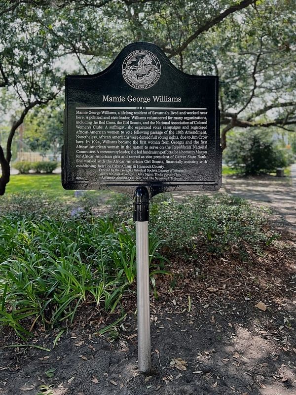
Mamie George Williams, a lifelong resident of Savannah, lived and worked near here. A political and civic leader, Williams volunteered for many organizations, including the Red Cross, the Girl Scouts, and the National Association of Colored Women's . . . — — Map (db m235241) HM
On East Anderson Street near Atlantic Avenue, on the right when traveling east.
The Blessed Pius X High School opened as a co-educational Diocesan School in 1952 serving students from Savannah's Black community. The Society of African Missions donated land for the school on property purchased by Father Ignatius Lissner. The . . . — — Map (db m238240) HM
On East Broad Street near East Gordon Lane, on the right when traveling south.
In May 1874 two Benedictine priests arrived
in Savannah to work with the city's African-
American community, and constructed a
church four blocks north of here. In 1889
a new building was constructed at this site.
The Society of African . . . — — Map (db m15721) HM
On W River Street, on the left when traveling east.
World War II Memorial
Honoring all veterans of
Chatham County who gave
their lives to retain the freedom
of the United States of America
and saved the world from tyranny — — Map (db m53069) WM
On Oglethorpe Avenue at Lincoln Street, on the left when traveling east on Oglethorpe Avenue.
Savannah Methodism's first church building was erected on this corner of Lincoln and South Broad (now Oglethorpe) streets in 1812 by its first pastor, Rev. James Russell. Bishop Francis Asbury preached twice in Wesley Chapel on November 21, 1813. In . . . — — Map (db m5447) HM
On East Upper Factors Walk north of East Bay Street, on the left when traveling west.
In 1840, the City hired architect Charles B. Cluskey to build part of a much-needed retaining wall along the north side of Bay Street, east of the City Exchange Building (where City Hall now stands). Cluskey used brick for his embankment wall. . . . — — Map (db m163922) HM
On East St Julian Street near Houston Street, on the left when traveling west.
This Chapel Is Dedicated To
A. Douglass Strobhar
As a mark of esteem and affection
by the Board of Managers
of the
Savannah Port Society
It is a tribute to his loyality and unfailing faithfulness since he became a member of the board . . . — — Map (db m6904) HM
On River Street near Bull Street, on the left when traveling south.
We were stolen, sold and bought together from the African Continent
We got on the slave ships together, we lay back to belly in the holds of the slave ships in each others excrement and urine together. Sometimes died together and our lifeless . . . — — Map (db m5278) HM
"This is no time to talk of moderation; in the
present instance it ceases to be a virtue."
Speech to Provincial Congress, June 5, 1776 Foremost among Georgia's Revolutionary patriots stood Archibald Bulloch whose remains rest in this . . . — — Map (db m5335) HM
On East River Street, 0.1 miles west of River Street Access, on the left when traveling east.
In 1739 General Oglethorpe thought about a unique concept whereas a historian could find unusual collectibles and local art works.
Now up these stairs in the heart of historic Savannah you can find these treasures at Arts & Crafts . . . — — Map (db m127964) HM
On Lincoln Street near East York Street, on the left when traveling south.
This Federal style house was constructed in the late eighteenth century as the residence of William Barnard, nephew of Sir John Barnard who, while serving in the British Parliament distinguished himself as a patron of the Georgia Colony
The . . . — — Map (db m9166) HM
On East Oglethorpe Avenue near Abercorn Street, in the median.
Chatham County Firefighters Memorial Last Alarm
Firefighters who have died in the line of duty
John Butler Fireman 1865 SFD Charles Schreck Fireman 1871 SFD George Puder Fireman 1873 SFD William L. Harroid Hoseman 1887 SFD John . . . — — Map (db m5641) HM
On Bull Street at Oglethorpe Avenue, on the right when traveling north on Bull Street.
Birthplace of
Juliette Gordon Low
Founder of Girl Scouts
In The United States
Owned and Operated
By The
Girl Scouts Of The U.S.A.
(Bottom):
The Juliette Gordon Low
birthplace
Has Been Designated A
National . . . — — Map (db m5582) HM
On East Oglethorpe Avenue at Bull Street, in the median on East Oglethorpe Avenue.
In the house that stands opposite this marker, Juliette Gordon Low, founder of the Girl Scouts of the United States of America, was born, October 31, 1860. It was her girlhood home until her marriage there in 1886 to William Low, an Englishman, . . . — — Map (db m5581) HM
On East Bay Street near Drayton Street, on the right when traveling west.
Directly across Bay Street from this marker formerly stood the brick building, built in late colonial days and known as the “Coffee House,” in which the Legislature of Georgia met in 1785. Owned by Thomas Stone, it was described in a . . . — — Map (db m6668) HM
This Memorial to
Button Gwinnett
Born 1735 Died 1777
Georgia Signer of The Declaration of Independence
President of Georgia
Whose remains, buried in this cemetery, are believed to lie entombed hereunder. Was erected by the . . . — — Map (db m241905) HM
On Abercorn Street, on the right when traveling north.
This grave links Savannah with one of history's greatest naval dramas - the epic fight in 1779 between the "Bon Homme Richard" and "Serapis" in which John Paul Jones immortalized himself.
Denis Nicolas Cottineau de Kerloguen received a commission . . . — — Map (db m5339) HM
Near Abercorn Street, on the right when traveling north.
In Honor and Grateful Memory of
Captain Denis Cottineau De Kerloguen
who was born in Nantes, France and died in Savannah Ga., November 20, 1808, aged 63 Years. In the war for American Independence he fought with John Paul Jones in the famous . . . — — Map (db m6452) HM
On East Harris Street near Abercorn Street, on the right when traveling north.
The congregation of St. John the Baptist formed in the late eighteenth century when French émigrés fleeing revolutions in France and Haiti found refuge in Savannah. The Church of St. John the Baptist became a cathedral in 1850 when the Diocese of . . . — — Map (db m6021) HM
On East Bay Street at Bull Street on East Bay Street.
Georgia Historical Society records
show that this building, built in 1853
for the Central Railroad & Bank was
confiscated by Gen. Wm. T. Sherman's
Union Army Forces as the military
hdqrs. of the Post Commandant, Gen.
J.W. Geary during the . . . — — Map (db m6477) HM
On East Upper Factors Walk north of East Bay Street, on the left when traveling west.
No images of Charles Blaney Cluskey appear to exist. He emigrated from Ireland in 1827 at age 19 and trained with a New York architectural firm for two years before moving to Savannah. He married Johanna Elizabeth Walsh two years later. Starting . . . — — Map (db m163907) HM
On East Bay Street south of Rossiter Place, on the left when traveling east.
On the front, south side is inscribed:
Dedicate May 4, 1986
To honor the members of the
Chatham Artillery
Servants of God, Country,
State and Community
—
Soldiers in War
Patriots in Peace
On the east side . . . — — Map (db m163909) HM
These bronze cannon were presented to the Chatham Artillery by President Washington after his visit to Savannah in 1791. Of English and French make, respectively, they are excellent examples of the art of ordnance manufacture in the 18th century. . . . — — Map (db m5519) HM
These cannon, which were captured when Lord Cornwallis surrendered at Yorktown in the American Revolution, were a gift to the Chatham Artillery by President George Washington - a mark of his appreciation for the part the local military company . . . — — Map (db m5517) HM
On Bull Street near E. Congress St., on the right when traveling south.
†
I.H.S.
Christ Church
Founded A.D. 1733. Chartered 1789.
Destroyed by Fire 1796. Rebuilt & enlarged 1803.
Injured by a hurricane 1804. Constructed anew 1810.
Taken down, and
This Edifice Erected
1838. Partially . . . — — Map (db m13665) HM
This Episcopal Church was the first house of
worship established with the founding of Georgia in 1733. Early rectors included the Rev. John Wesley (1736-37), who began the earliest form of Sunday school and published the first English hymnal in . . . — — Map (db m5304) HM
On Abercorn Street, on the right when traveling north.
(upper marker): Christ Church Parish House
(lower marker): The
hand wrought weather vane
atop this building
is from the 12th century church of
Cranham, Essex, England
where Gen. James Edward Oglethorpe
is . . . — — Map (db m6115) HM
For, Savannah, Christmas 1864 was anything but a time
for merriment. Almost four years of war had taken the
lives of thousands of Georgians, destroyed millions of
dollars in property and left the state in chaos. As the
holiday approached, so . . . — — Map (db m19422) HM
Near Houston Street at East Mc Donough Street, on the left when traveling south.
Many of the city’s squares contained water cisterns to aid in firefighting. They were kept filled with water and weekly reports of the condition and water depth were made to the City Council. Their depth ranged from 9 feet 2 inches to 13 feet 5 . . . — — Map (db m133138) HM
On Abercorn Street, on the right when traveling north.
James S. McIntosh achieved an immortal record of gallantry in the War of 1812 and in the War with Mexico. In 1814 he saw considerable action on the Canadian border, he was severely wounded at Buffalo. In the Mexican War, Col. McIntosh was . . . — — Map (db m81621) HM
This cemetery, the second in colonial Savannah, was the burying ground for the city from about 1750 until it was closed against burials in 1853. Among the distinguished dead who rest here are Archibald Bulloch, first President of Georgia; James . . . — — Map (db m5313) HM
On E. State Street near Habersham, on the left when traveling west.
In 1757, during the administration of royal Governor Henry Ellis, a line of earthwork defenses, including a palisade, was erected around Savannah. Immediately west of this marker was located Bethesda Gate, one of the six entrances into the town. . . . — — Map (db m5356) HM
On East River Street, on the left when traveling east.
The election of Abraham Lincoln in 1860 brought years of festering political differences between Southern and Northern states to a head. In mid-January 1861 Georgia delegates voted to secede from the Union. The April 1861 bombardment and surrender . . . — — Map (db m19676) HM
Conrad Aiken, Poet and Man of Letters, was born in Savannah on August 5, 1889, and lived at No. 228 (opposite) until 1901. After the tragic deaths of his parents, he was moved to New England. Most of his writing career was divided between Cape Cod, . . . — — Map (db m5310) HM
On Hull Street at Bull Street, on the left when traveling west on Hull Street.
One block west of this marker -- at the northwest corner of Hull and Whitaker Streets -- stood,
formerly, the residence of William Alexander Caruthers, Virginia's earliest significant novelist. He resided in Savannah for several years before his . . . — — Map (db m5920) HM
The epitaph to James Wilde on the nearby tomb is a melancholy reminder of the days of duelling and, particularly, of a tragic affair of honor fought January 16, 1815, on the Carolina side of the river near Savannah. Lieutenant Wilde was shot through . . . — — Map (db m5376) HM
Beneath this modest slab rest the remains of America's foremost painter of miniatures. Malbone, a native of Rhode Island, began his career in Providence at the age of seventeen. He pursued his calling in Boston, New York, Philadelphia, Charleston . . . — — Map (db m5369) HM
On West Bay Street near Jefferson Street, on the right when traveling west.
On Dec. 14, 1864, Fort McAllister (CS) having fallen the day before, opening the Great Ogeechee River to Union shipping and rendering Savannah untenable, Lt. Gen. W. J. Hardee, CSA, decided to evacuate the city to save it from a destructive . . . — — Map (db m5574) HM
On Bull St near W. State St., on the right when traveling south.
Entered on the National Register
of Historic Places
June 7, 1974
Federal Building
U.S. Courthouse
Wright Square Postal Station
Savannah, Georgia
Jeremiah O'Rourke
Architect 1899
This Property Significantly Contributes . . . — — Map (db m19824) HM
On West Bryan Street at Montgomery Street, on the left when traveling west on West Bryan Street.
First African Baptist Church (FABC) traces its roots to 1773 and the organization of a congregation at nearby Brampton Plantation by Rev. George Leile. Under the leadership of Rev. Andrew C. Marshall (3rd pastor), the congregation obtained this . . . — — Map (db m133007) HM
On Bull St. near W. McDonough St., on the right when traveling south.
On November 26, 1800 the Reverend Henry Holcombe
and fifteen other Baptists organized the Savannah
Baptist Church. As early as 1795 a group of interested
Baptists had erected a house of worship on Franklin
Square where the congregation . . . — — Map (db m13663) HM
On Bull St. near W. McDonough St., on the right when traveling south.
First Baptist Church, Savannah’s oldest standing house of worship, was designed by Elias Carter and completed in 1833. The congregation dates to 1800. In 1922 the front of the building was extended, a cupola removed, and the edifice covered with . . . — — Map (db m13608) HM
On East Macon Street, on the right when traveling east.
The house adjacent to this building was the home of Juliette Gordon Low at the time she founded Girl Scouting in the United States, March 12, 1912. Formerly the carriage-house and stable of the Low mansion, this building became that year the first . . . — — Map (db m5583) HM
On Montgomery Street, on the right when traveling south.
(Right Marker):
Flame of Freedom
1919 - 1969
Dedicated to the
Glory of God
A fitting reminder of this precious heritage,
a tribute to all who offered their lives to
preserve it. A gift to our Community by the
American . . . — — Map (db m7311) HM
On Abercorn St. near E. State St. when traveling south.
Site of the Home
Presented By The State Of Georgia
— To —
Major General James Jackson
Born 1757 - Died 1806
Revolutionary Hero, Statesman,
And Governor Of Georgia
Placed By
The Savannah Chapter Of The
Daughters Of The . . . — — Map (db m241597) HM
Samuel Elbert, who became brigadier general in the Continental Army and governor of Georgia, migrated to this province from South Carolina as an orphan youth during the Colonial period. He prospered in mercantile pursuits and as an Indian trader; . . . — — Map (db m5340) HM
On Abercorn St, on the right when traveling north.
Lachlan McIntosh, Georgia's ranking Continental officer in the American Revolution, was the son of John Mor Mackintosh who settled with a group of Highlanders on the Altamaha in 1736. Lachlan served as a cadet in Oglethorpe’s Regiment and received . . . — — Map (db m5400) HM
On W State Street at Barnard Street, on the right when traveling west on W State Street.
During his visit to Savannah May 12-15 1791 was a guest at the Inn which stood on the northwest corner of Barnard and State Streets. This tablet is placed in commemoration of the bi-centenary of his birth by the Daughters of the American Revolution . . . — — Map (db m241960) HM
On Barnard Street, on the left when traveling south.
This Fountain Commemorates The Religious,
Social, Agricultural, Economic, And Political
Contributions Of Early German Immigrants
To The Establishment And Growth
Of The Colony Of Georgia.
erected And Dedicated in 1989
By Their . . . — — Map (db m5474) HM
On E. Oglethorpe Ave, on the right when traveling east.
In this cemetery many victims of the Great Yellow Fever Epidemic
of 1820 were buried.
Nearly 700 Savannahians died that year, including two local physicians who lost their lives caring for the stricken.
Several epidemics followed. In . . . — — Map (db m5330) HM
On Montgomery Street near West Julian Street, on the left when traveling north.
> (West face)
In its fourth year, the American Revolution had become an international conflict. Rebelling American Colonies and their French allies attempted to capture Savannah from the British in 1779. Haitian soldiers of African descent . . . — — Map (db m22345) HM
On Bull Street at Harris Street, on the left when traveling south on Bull Street.
On January 12, 1865, U.S. Secretary of War Edwin Stanton and General Wm. T. Sherman met here at the home of Charles Green with 20 leaders from Savannah’s African-American churches, including Garrison Frazier, Ulysses L. Houston, and William . . . — — Map (db m40696) HM
On East Oglethorpe Avenue, on the right when traveling west.
First Constitutional Session
of the Georgia Legislature
held in the "Long Room"
Jany 1783
Headquarters
Genl George Washington
May 1791 — — Map (db m6470) HM
On Houstoun Street at York Street, on the right when traveling south on Houstoun Street.
Houstoun Street
Named in honor of
John Houstoun
Governor of Georgia, 1778
First Mayor of Savannah. 1790
York Street
Laid out in 1733
Named in honor of
Duke Of York — — Map (db m16799) HM
Hugh McCall who is buried here was the author of the first history of Georgia.
Forced by ill health into retirement, McCall, who was a Brevet Major, U.S. Infantry, became interested in the history of his adopted State. In spite of severe . . . — — Map (db m5372) HM
On Bull Street near Oglethorpe Avenue, on the left.
The Independent Presbyterian Church was organized in 1755. The first meeting house stood facing Market Square in Savannah, between what are now St. Julian and Bryan Streets, on property granted by King George II for the use and benefit of those . . . — — Map (db m5515) HM
On East River Street, on the left when traveling east.
During the Civil War, the Savannah River Squadron protected the City of Savannah from Union attack by river. The
squadron usually consisted of small coastal and river steamers. In November 1861, the British-built blockade-runner Fingal . . . — — Map (db m19773) HM
When James Oglethorpe left England to begin the new colony of Georgia, in 1732, one of the passengers was Paul Amatis, an Italian artisan, skilled in producing silk. He was later placed in charge of Trustees Garden. Later, more Italian familes came . . . — — Map (db m9390) HM
On Bull Street at East Hull Street, on the left when traveling north on Bull Street.
The monument in this Square to James Edward Oglethorpe - the great soldier-philanthropist who founded the colony of Georgia - was erected by the State of Georgia, the City of Savannah and various Patriotic Societies. Impressive ceremonies marked . . . — — Map (db m5308) HM
Here rests James Habersham -- associate of George Whitefield and a leading merchant, planter, and public servant during Georgia's colonial era. Mr. Habersham came to the colony in 1738 as a youthful follower of the Rev. Whitefield and collaborated . . . — — Map (db m5357) HM
Here repose the remains of James Johnston (1738-1808) - - editor of Georgia's first newspaper. A native of Scotland, Johnston settled at Savannah in 1761. "Recommended as a person regularly bred and well skilled in the Art and mystery of . . . — — Map (db m5388) HM
On East Oglethorpe Ave. near Bull Street, in the median.
The residence opposite this site, known as the Gordon House, was built between 1819-1821. A fine example of Regency architecture, it was designed by the eminent architect, William Jay. The third story and side porch were later added.
The house . . . — — Map (db m5575) HM
On East Bay Street, on the right when traveling west.
Jane Cuyler (born Jeanne de la Touche) came to Savannah with her husband Teleman in 1768. After his
death in 1772, Cuyler took in lodgers, first at her home on the corner of Bull and Broughton Streets,
then at an undetermined location on Bay . . . — — Map (db m6159) HM
Near this site on July 11, 1733, five months
after Oglethorpe founded Georgia, 42 Jewish
colonists, having sailed from London,
disembarked from the William and Sarah.
It was the largest group of Jews ever to sail
on one vessel from . . . — — Map (db m26707) HM
On W. Bay Street near Whitaker St., on the right when traveling west.
Joel Chandler Harris (1845-1908), New South journalist and author of Uncle Remus tales,
Free Joe, and many other works, was associate editor of the Savannah Morning News
from 1870 until 1876, under William Tappan Thompson, an . . . — — Map (db m25357) HM
On Houston Street at E. St Julian Street, on the right on Houston Street.
Dedicated in memory of
John B. Hohenstein, Sr.
Partner of Hohenstein Shipping Company,
Secretary and Treasurer of Savannah Pilotage
Commission, who prominently served the
maritime industry of Savannah from 1919
until his death, April 20, . . . — — Map (db m16770) HM
Savannah native, Johnny Mercer, was a lyricist, composer, performer, collaborator, businessman, philanthropist, and mentor. He penned nearly 1,400 songs, with the most famous being “Moon River.”
He was the co-founder of Capitol Records, Inc. . . . — — Map (db m73471) HM
Near Bull St. near E. Congress St., on the left when traveling north.
( Caricature )
Johnny Mercer
Lyricist Songwriter
Co-founder of Capitol Records Winner of 4 Academy Awards
Front Rim reads;
Ac-cent-tchu-ates The Positive - Autumn Leaves - Blues In The Night - Charade - Jeepers Creepers - . . . — — Map (db m13683) HM
On W.Bay St. at Montgomery St., on the right when traveling west on W.Bay St..
On this site in 1852 stood the Excelsior Bottle Works operated by John Ryan for the manufacture of soda water and other carbonated beverages. Ryan's soda, in colorful bottles embossed with his name and location, was known throughout Georgia. His . . . — — Map (db m14495) HM
On Bull St near Bay St., on the left when traveling south.
On this spot, where stood the
first public building erected in
Georgia, John Wesley preached
his first sermon on American soil.
March 7, 1736 (OS)
Text- 1 Corinthians XIII
— • —
This tablet commemorates the Bi-Centenary . . . — — Map (db m14128) HM
On Abercorn Street near E. St. Julian Street, on the left when traveling south.
South face:
Founder of Methodism
Minister
Of The
Church of England
In Savannah
1736-1737
East face:
My hearts desire
for this place
is not that it be
a famous or rich
but that it may be
a religous colony . . . — — Map (db m15622) HM
On the "trust lot" south of President Street and immediately west of this square stood in 1736- 37 the parsonage in which John Wesley resided. In the adjoining garden he read, prayed and meditated. Weekly meetings of members of his Christ Church . . . — — Map (db m5275) HM
Johnson Square is named for Governor Robert Johnson of South Carolina who befriended the colonists when Georgia was first settled. It was laid out by Oglethorpe and by Colonel William Bull in 1733, and was the first of Savannah's squares. In early . . . — — Map (db m5494) HM
On Montgomery Street near W. Bryan Street, on the left when traveling north.
Born in Pocotaligo, SC, Jonathan Bryan accompanied James Oglethorpe on his initial visit to Yamacraw Bluff in 1733. One of Georgia’s largest landholders, Bryan was a supporter of evangelist George Whitefield and encouraged religious services for his . . . — — Map (db m41816) HM
A native of Yorkshire, Joseph Clay (1741-1804) settled at Savannah at the age of nineteen. His uncle, James Habersham, declared that his "industry" was "highly commendable" and "his Abilities for Trade unquestionable." Fulfilling his early promise, . . . — — Map (db m5364) HM
The three Habersham brothers - who here rest beside their distinguished father, James Habersham - were prominent patriots in the American Revolution and outstanding public men during the early years of the republic. JOSEPH . . . — — Map (db m5361) HM
There was "None, No None!" reads the epitaph on this tomb.
"Against Whose Name the Recording Angel Would More Reluctantly Have Written Down Condemnation."
Born at Dublin, Ireland. Son of a Georgia planter, Joseph V. Bevan attended the Univ. of . . . — — Map (db m5551) HM
On Bay St at Bull St., on the right when traveling west on Bay St.
James Edward Oglethorpe, the founder of Georgia, landed with the original colonists, about 114 in number, at the foot of this bluff on February 1 (February 12, new style), 1733. The site where he pitched his tent is marked by the stone bench . . . — — Map (db m5263) HM
On Bull Street near Oglerthorpe Street, on the right.
Lowell Mason, noted composer of sacred music, was organist of the Independent Presbyterian Church (1820- 1827), and Superintendent of its Sunday School (1815- 1827). A native of New England, Mason moved to Savannah at the age of twenty. He resided . . . — — Map (db m5635) HM
On Bull Street near President Street, on the left when traveling north.
On April 14, 1741, John Martin Bolzius, who as Pastor of the Salzburgers at Ebenezer was in charge of Lutheran work in the colony of Georgia, founded the congregation now known as the Lutheran Church of the Ascension. In 1756 members of the . . . — — Map (db m6601) HM
Madison Square was laid out in 1839 and is named for the fourth President of the United States. Around the Square stand notable examples of Greek Revival, Gothic, and Romanesque architecture characteristic of nineteenth century Savannah.
To the . . . — — Map (db m6377) HM
Through this square ran the southern line of defenses of the British who held Savannah from December 29, 1778 to July 11, 1782. After a siege of 22 days, at dawn of October 9, 1779, the strong western defenses on the line of the present West Broad . . . — — Map (db m71986) HM
In 1775 John Berrien of New Jersey came to the province of Georgia, where one of his mother's kin had previously settled. His father, John Berrien (1711-1772), was a judge of the supreme court of New Jersey and a trustee of Princeton College. From . . . — — Map (db m5341) HM
Beneath the monument in this Square repose the remains of Maj. Gen. Nathanael Greene, of Rhode Island, who died near Savannah on June 19, 1786, at Mulberry Grove Plantation which had been granted to him by this State in appreciation of his services . . . — — Map (db m5442) HM
This tomb, known as the Graham vault, possesses the distinction of having been the burial place of two heroes of the Revolutionary War, one American and the other British.
Lt. Col. John Maitland of Lauder, Scotland, son of the 6th Earl of . . . — — Map (db m5342) HM
On East Broad Street near East Bay Street, on the left when traveling south.
On this site
During the 1730's the Trustees of the Georgia Colony, aided by funds from the Worshipful Society Of Apothecaries of London sought to grow New World medical plants both for their therapeutic value and for the enrichment of empire. The . . . — — Map (db m6185) HM
On West Bay Street near Whitaker Street, on the left when traveling east.
On this spot one hundred and seventy three years ago James Oglethorpe the founder of the colony pitched his tent and here rested at the close of the day from which Georgia was settled. — — Map (db m16064) HM
On Bay Street at Bull Street, on the right when traveling east on Bay Street.
1736-1740
On this site stood the house
occupied by James Edward Oglethorpe
when in Savannah.
His home he made in Frederica
the better to protect
the young colony — — Map (db m6499) HM
On Bay St at Drayton St, on the right when traveling north on Bay St.
This bell, which is believed to be the oldest in Georgia, bears the date 1802. Imported from Amsterdam, it hung in the cupola of the City Exchange from 1804 until a short time before that building was razed to make way for the present City Hall. . . . — — Map (db m4913) HM
On East Bay Street., on the right when traveling west.
This beacon light was erected by the Federal government in 1858 as an aid to navigation of the Savannah River. Standing 77 feet above the river level and illuminated by gas, it served for several years as a guide to vessels passing over the hulls . . . — — Map (db m5476) HM
On Bay Street (State Highway 25) near Drayton Street, on the left when traveling south.
The Savannah Cotton Exchange building was completed in 1887 during the era when Savannah ranked first as a cotton seaport on the Atlantic and second in the world. In its heyday as a cotton port over two million bales a year moved through Savannah. . . . — — Map (db m4904) HM
283 entries matched your criteria. The first 100 are listed above. Next 100 ⊳