
72 entries match your criteria.
Entries Containing All of the Phrases «mecklenburg county» AND «north carolina»
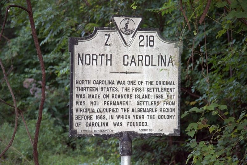
By J. J. Prats, August 20, 2017
North Carolina Face of Marker
RANKED BY RELEVANCE
1 ► Virginia, Mecklenburg County, Boydton — Z-218 — Mecklenburg County Virginia / North Carolina —  |
| On U.S. 1 near the state line, on the right when traveling south. | |||
| 2 ► North Carolina, Mecklenburg County, Charlotte — Historic Memorial Grave Stones — |
| Near Steele Creek Road (North Carolina Route 160) 0.1 miles south of Dorcas Lane, on the left when traveling south. | |||
| 3 ► North Carolina, Mecklenburg County, Charlotte, Elizabeth — Mecklenburg County Vietnam Memorial — Dedicated November 11, 1989 — |
| Near East 4th Street (State Highway 16) 0.1 miles west of South Kings Drive, on the left when traveling west. | |||
| 4 ► North Carolina, Mecklenburg County, Pineville — Polk Family Cemetery — President James K. Polk State Historic Site — |
| Near James K. Polk Road (County Highway 3640) 0.1 miles east of Lancaster Highway. | |||
| 5 ► North Carolina, Mecklenburg County, Huntersville — General William Lee Davidson — |
| On Beatties Ford Road north of Sample Road, on the right when traveling north. | |||
| 6 ► North Carolina, Cabarrus County, Harrisburg — In Memory of Alexander Query and Peggy McCord Query — |
| Near North Carolina Route 49 at Morehead Road, on the right when traveling south. | |||
| 7 ► North Carolina, Lincoln County, Lincolnton — The Aftermath — |
| On Jeb Seagle Drive at Linwood Drive, on the left when traveling west on Jeb Seagle Drive. | |||
| 8 ► North Carolina, Lincoln County, Lincolnton — War Comes to North Carolina's Backcountry — |
| On Jeb Seagle Drive at Linwood Drive, on the left when traveling west on Jeb Seagle Drive. | |||
| 9 ► North Carolina, Mecklenburg County, Charlotte, Charlotte center city — Independence Square — |
| On East Trade Street at South Tryon Street, on the right when traveling east on East Trade Street. | |||
| 10 ► North Carolina, Mecklenburg County, Charlotte, Charlotte center city — Mint Building — Charles R. Jonas Federal Building — |
| On West Trade Street at South Mint Street, on the right when traveling east on West Trade Street. | |||
| 11 ► North Carolina, Mecklenburg County, Charlotte, Charlotte center city — Romare Bearden — 1911-1988 — |
| On South Church Street at West 3rd Street, on the right when traveling south on South Church Street. | |||
| 12 ► North Carolina, Mecklenburg County, Charlotte, Providence Plantation — Henry Downs — Revolutionary War Patriot — |
| Near Providence Church Lane 0.1 miles south of Providence Road ( Highway 16), on the left when traveling south. | |||
| 13 ► North Carolina, Mecklenburg County, Charlotte, Sharon Woods — Ezra Alexander — |
| Near Sharon Road (State Road 3600) 0.2 miles south of Sharon View Road (State Road 3673), on the left when traveling south. | |||
| 14 ► North Carolina, Mecklenburg County, Charlotte, Sugar Creek — Sugaw Creek Presbyterian Church — |
| On West Craighead Road at Glory Street, on the right when traveling north on West Craighead Road. | |||
| 15 ► North Carolina, Mecklenburg County, Huntersville — General William Lee Davidson — |
| Near North Carolina Route 73 at McGuire Nuclear Stat Roadd, on the right when traveling east. | |||
| 16 ► North Carolina, Mecklenburg County, Huntersville — Hugh Torance — (1743-1816) — |
| On Gilead Road 0.1 miles west of Old Store Road, on the right when traveling west. | |||
| 17 ► North Carolina, Mecklenburg County, Huntersville — John McKnitt Alexander — |
| Near Beatties Ford Road (State Road 2074) at Sample Road (State Road 2125), on the right when traveling north. | |||
| 18 ► North Carolina, Mecklenburg County, Huntersville — William Graham — |
| Near Beatties Ford Road (State Road 2074) at Sample Road (State Road 2125), on the right when traveling north. | |||
| 19 ► North Carolina, Mecklenburg County, Mint Hill — Adam Alexander — |
| Near Brief Road 0.3 miles west of Quail Cove Court, on the right when traveling west. | |||
| 20 ► Tennessee, Maury County, Columbia — The Polk Family — |
| Near West 4th Street at North Main Street. | |||
| 21 ► North Carolina, Mecklenburg County, Charlotte, Ballantyne — Human Spirit — |
| Near Ballantyne Commons Parkway at Johnston Road (U.S. 521), on the right when traveling west. | |||
| 22 ► North Carolina, Mecklenburg County, Charlotte, Charlotte center city — Census Information — |
| On West 5th Street just west of North Church Street, on the right when traveling west. | |||
| 23 ► North Carolina, Mecklenburg County, Charlotte, Charlotte center city — Establishing A New Life — |
| On West 5th Street just west of North Church Street, on the right when traveling west. | |||
| 24 ► North Carolina, Mecklenburg County, Charlotte, Charlotte center city — Line of the American Retreat — Battle of Charlotte, September 26, 1780 — |
| On West 5th Street at North Tryon Street, on the left when traveling east on West 5th Street. | |||
| 25 ► North Carolina, Mecklenburg County, Charlotte, Charlotte center city — The Mecklenburg Declaration of Independence — |
| On West 5th Street just west of North Church Street, on the right when traveling west. | |||
| 26 ► North Carolina, Mecklenburg County, Charlotte, Charlotte center city — The War Between The States — |
| On West 5th Street just west of North Church Street, on the right when traveling west. | |||
| 27 ► North Carolina, Mecklenburg County, Charlotte, Freedom Park — The North Carolina Liberty Tree — |
| On Princeton Avenue. | |||
| 28 ► North Carolina, Mecklenburg County, Charlotte, Charlotte center city — L-18 — Battle of Charlotte — |
| On S. Tryon Street 0 miles south of Trade Street, on the right when traveling north. | |||
| 29 ► North Carolina, Mecklenburg County, Charlotte, Sugar Creek — Alexander Craighead — (Creaghead) — b. March 1707 in Donegal IE. d. March 1766 in Mecklenburg — |
| Near West Craighead Road south of Glory Street, on the right when traveling south. | |||
| 30 ► Alabama, Dallas County, Selma — Valley Creek Presbyterian Church — One of state’s first Presbyterian churches — |
| On State Highway 22 at County Road 65, on the right when traveling south on State Highway 22. | |||
| 31 ► Illinois, Union County, Mill Creek — Revolutionary War Veterans — |
| On Saint Johns Road 0.3 miles east of Jonesboro Quarry Road, on the right when traveling west. | |||
| 32 ► North Carolina, Mecklenburg County, Charlotte, Charlotte Center City — African-American Contributions During the American Revolution — Charlotte Liberty Walk — |
| On South Tryon Street at East Brooklyn Village Avenue, on the right when traveling north on South Tryon Street. | |||
| 33 ► North Carolina, Mecklenburg County, Charlotte, Charlotte center city — Gold Mining — |
| On West 5th Street just west of North Church Street, on the right when traveling west. | |||
| 34 ► North Carolina, Mecklenburg County, Charlotte, Charlotte center city — The Origin Of Our Names — |
| On West 5th Street just west of North Church Street, on the right when traveling west. | |||
| 35 ► North Carolina, Mecklenburg County, Charlotte, Charlotte center city — Union Farmers — 43rd Regiment North Carolina Troops, Company B — C.S.A. — |
| Near West 6th Street 0.2 miles west of North Graham Street, on the right when traveling west. | |||
| 36 ► North Carolina, Mecklenburg County, Huntersville — The Oldest Cemetery and the Walls — |
| Near Beatties Ford Road at Sample Road, on the right when traveling north. | |||
| 37 ► North Carolina, Mecklenburg County, Pineville — Tobacco in the Piedmont — President James K. Polk State Historic Site — |
| On James K. Polk Road (County Road 3640) 0.1 miles east of Lancaster Highway, on the left when traveling east. | |||
| 38 ► South Carolina, York County, Blacksburg — Major William Chronicle — Oct. 7, 1780 — |
| Near Park Road, on the right when traveling east. | |||
| 39 ► South Carolina, York County, Blacksburg — Sacred to the Memory Monument — |
| Near Park Road, on the right when traveling east. | |||
| 40 ► South Carolina, York County, McConnells — The James Williamson Plantation and Log House — Huck's Defeat Battlefield Trail — |
| Near Brattonsville Road north of Percival Road (South Carolina Road 46-380), on the right when traveling north. | |||
| 41 ► Virginia, Mecklenburg County, Chase City — 36 — Thyne Institute — Chase City, Virginia — Mecklenburg County |
| On Highway Forty Seven (Virginia Route 47) at Village Road ( Route 874), on the left when traveling west on Highway Forty Seven. Reported permanently removed. | |||
| 42 ► North Carolina, Guilford County, Greensboro — JJ-1 — The Presbyterian Church in North Carolina — |
| On Presbyterian Road 0.1 miles south of Millpoint Road, on the right when traveling south. | |||
| 43 ► North Carolina, Mecklenburg County, Charlotte, Charlotte center city — Ranaleburg Riflemen — 13th Regiment North Carolina Troops, Company B — C.S.A. — |
| Near West 6th Street 0.2 miles west of North Graham Street, on the right when traveling west. | |||
| 44 ► North Carolina, Mecklenburg County, Charlotte, Charlotte center city — St. Peter's Episcopal Church — |
| On N Tryon St. | |||
| 45 ► North Carolina, Mecklenburg County, Charlotte, Charlotte center city — Thomas Polk Park — |
| On South Tryon Street at West Trade Street, on the right when traveling south on South Tryon Street. | |||
| 46 ► North Carolina, Mecklenburg County, Charlotte, Henderson Circle — Signers of Mecklenburg Declaration of Independence — May 20, 1775 — |
| On Old Statesville Road (State Highway 115) south of Independence Hill Road. | |||
| 47 ► North Carolina, Mecklenburg County, Charlotte, Providence Plantation — Providence Presbyterian Church — |
| On Providence Church Lane 0.1 miles Providence Road (North Carolina Highway 16), on the left when traveling south. | |||
| 48 ► North Carolina, Mecklenburg County, Pineville — The Polk Farm — President James K. Polk State Historic Site — |
| On James K. Polk Road (County Road 3640) 0.1 miles east of Lancaster Highway, on the left when traveling east. | |||
| 49 ► North Carolina, Mecklenburg County, Charlotte, Freedom Park — Freedom Park — |
| On Lilac Road at Cumberland Avenue, on the right when traveling east on Lilac Road. | |||
| 50 ► North Carolina, Mecklenburg County, Charlotte, Myers Park — Freedom Park — |
| On Princeton Avenue at Sterling Road, on the right when traveling west on Princeton Avenue. | |||
| 51 ► Georgia, White County, Sautee Nacoochee — Three Families at the Farm — |
| Near Georgia Route 17 north of Unicoi Turnpike, on the right when traveling west. | |||
| 52 ► North Carolina, Lincoln County, Lincolnton — The Battle of Ramsour's Mill — |
| Near Jeb Seagle Drive 0.2 miles north of Linwood Drive, on the left when traveling north. | |||
| 53 ► North Carolina, Mecklenburg County, Charlotte, Charlotte center city — Ephraim Brevard — |
| Near West 5th Street at North Church Street, on the right when traveling west. | |||
| 54 ► North Carolina, Mecklenburg County, Charlotte, Charlotte center city — Mecklenburg Declaration of Independence — Charlotte Liberty Walk — |
| On South Tryon Street at East Trade Street, on the left when traveling south on South Tryon Street. | |||
| 55 ► North Carolina, Mecklenburg County, Charlotte, Charlotte center city — The Sculptures at Independence Square — Bronze Boundary Figures by Raymond Kaskey — Given to the people of Charlotte by the Queens Table, November 1995 — |
| On North Tryon Street at East Trade Street, on the right when traveling north on North Tryon Street. | |||
| 56 ► North Carolina, Mecklenburg County, Charlotte, Elizabeth — 6 — Dr. Annie Alexander — First Woman Doctor — Charlotte Trail of History — |
| Near North Kings Drive at Elizabeth Avenue, on the right when traveling south. | |||
| 57 ► North Carolina, Mecklenburg County, Huntersville — Hugh Torance House & Store c. 1779 — |
| Near Gilead Road 0.1 miles west of Old Store Road, on the right when traveling west. | |||
| 58 ► North Carolina, Mecklenburg County, Huntersville — The Church Building — |
| On Beaties Ford Road north of Sample Road, on the right when traveling north. | |||
| 59 ► North Carolina, Mecklenburg County, Pineville — L-38 — North Carolina / South Carolina — |
| On Rock Hill Pineville Road (Highway 51) 0.1 miles west of Miller Road. | |||
| 60 ► Virginia, Mecklenburg County, Chase City — MK1 — Thyne Institute — Chase City, Virginia — Mecklenburg County — |
| On State Highway 47 just west of Village Road (State Route 874), on the left when traveling west. | |||
| 61 ► North Carolina, Mecklenburg County, Charlotte, Charlotte center city — Mecklenburg Beauregards — 30th Regiment North Carolina Troops. Company K — C.S.A. — |
| Near West 6th Street 0.2 miles west of North Graham Street, on the right when traveling west. | |||
| 62 ► North Carolina, Mecklenburg County, Charlotte, Freedom Park — Freedom Park — |
| Near Cumberland Avenue at Lilac Road, on the left when traveling south. | |||
| 63 ► South Carolina, York County, McConnells — The Homestead |
| On Brattonsville Road 0.1 miles north of Percival Road, on the right when traveling south. Reported missing. | |||
| 64 ► Tennessee, Davidson County, Nashville, North Capitol — Tomb of James Knox Polk — James Knox Polk, — President of the U.S. Born Nov. 2, 1795, Died June 15, 1849. — |
| Near Charlotte Avenue. | |||
| 65 ► State Historical Markers Numbering Plans |
| 66 ► North Carolina, Alamance County, Burlington — Battle of Clapp's Mill — |
| Near Huffman Mill Road. | |||
| 67 ► North Carolina, Mecklenburg County, Charlotte, Charlotte center city — Fourth Ward Historic District — Neighborhood Area Map & House Listing |
| On West 6th Street at North Poplar Street, on the right when traveling west on West 6th Street. Reported unreadable. | |||
| 68 ► North Carolina, Mecklenburg County, Charlotte, Fourth Ward — Overcarsh House — |
| On West 8th Street at North Pine Street, on the right when traveling west on West 8th Street. | |||
| 69 ► North Carolina, Mecklenburg County, Davidson — Beaver Dam — circa 1829 — |
| Near Davidson-Concord Road 0.2 miles south of Robert Walker Drive, on the left when traveling south. | |||
| 70 ► South Carolina, Anderson County, Iva — 4-31 — Generostee A.R.P. Church — |
| On Parker Bowie Road. | |||
| 71 ► North Carolina, Mecklenburg County, Charlotte, Oxford Hunt — Grier-Rea House — |
| On Providence Road (State Highway 16) at Alexander Road/Rea Road, on the right when traveling north on Providence Road. | |||
| 72 ► North Carolina, Beaufort County, Bunyan — B-8 — Granville Grant — |
| On John Small Avenue (U.S. 264) near Eborn Lane, on the right when traveling east. | |||
Thin black lines indicate changes in relevance. Between each pair of lines entries are ordered geographically but all have the same relevance.
* Inflectional forms of words are their plurals, singulars, and possessives as well as gramatical tenses and similar variations.
Nov. 22, 2026