
52 entries match your criteria.
Entries Containing All of the Phrases «rutherford county» AND «tennessee»
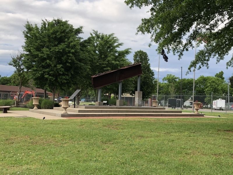
By Duane and Tracy Marsteller, May 4, 2025
Rutherford County, Tennessee, Sheriff's Office 9-11 Memorial
RANKED BY RELEVANCE
1 ► Tennessee, Rutherford County, Murfreesboro — Rutherford County, Tennessee, Sheriff's Office 9-11 Memorial —  |
| On Detention Drive 0.1 miles west of New Salem Highway (Tennessee Route 99), on the right when traveling west. | |||
| 2 ► Tennessee, Rutherford County, Murfreesboro — 1860s View of East Main Street — Rutherford County, Tennessee — |
| On South Church Street at East Main Street, on the left when traveling north on South Church Street. | |||
| 3 ► Tennessee, Rutherford County, Murfreesboro — Architecture on the Square — Rutherford County, Tennessee — |
| On North Public Square at North Maple Street, on the left when traveling west on North Public Square. | |||
| 4 ► Tennessee, Rutherford County, Murfreesboro — Uncle Dave Macon (1870-1952) — Rutherford County, Tennessee — |
| On 312 S Front Street. | |||
| 5 ► Tennessee, Rutherford County, Murfeesboro — Uncle Dave Mason (1870-1952) — Rutherford County, Tennessee — |
| Near South Front Street west of South Front Street. | |||
| 6 ► Tennessee, Rutherford County, Murfreesboro — Murfreesboro History — Rutherford County, Tennessee — |
| Near South Public Square. | |||
| 7 ► Tennessee, Rutherford County, Murfreesboro — 3A 239 — Robert Smith Sanders, M. D. — 1927-2006 — |
| On West Burton Street at North Maple Street, on the right when traveling west on West Burton Street. | |||
| 8 ► Tennessee, Rutherford County, Murfreesboro — Rutherford County Courthouse — |
| On North Public Square at North Church Street, on the left when traveling west on North Public Square. | |||
| 9 ► Tennessee, Rutherford County, Murfreesboro — Federal Troops on the Square — |
| On North Public Square at Maple Street, on the left when traveling west on North Public Square. | |||
| 10 ► Tennessee, Rutherford County, Murfreesboro — Murfreesborough — |
| Near Northwest Broad Street (U.S. 41) north of Memorial Boulevard (State Highway 96), on the left when traveling north. | |||
| 11 ► Tennessee, Rutherford County, Murfreesboro — The Founding of the County — |
| On North Public Square west of North Church Street. | |||
| 12 ► Tennessee, Rutherford County, Murfreesboro — The Square During Occupation — |
| On South Public Square east of South Maple Street, on the left when traveling west. | |||
| 13 ► Tennessee, Rutherford County, Murfreesboro — General Griffith Rutherford — 1721 -1805 — |
| On North Public Square at North Maple Street, on the left when traveling west on North Public Square. | |||
| 14 ► Tennessee, Williamson County, Franklin — The Long Road to Recovery — |
| Near Eastern Flank Circle 0.4 miles south of Lewsiburg Pike (Business U.S. 431), on the right when traveling west. | |||
| 15 ► Tennessee, Rutherford County, Murfreesboro — 3A 248 — Mary Ellen Vaughn — 1893-1953 — |
| On South Highland Avenue at Vaughn Street, on the right when traveling north on South Highland Avenue. | |||
| 16 ► Tennessee, Rutherford County, Murfreesboro — Slave, Soldier, Citizen — |
| On Old Nashville Highway, on the right when traveling north. | |||
| 17 ► North Carolina, Rutherford County, Rutherfordton — Rutherfordton — “… did it no good” — Stoneman’s Raid — |
| On North Main Street (U.S. 221) south of Trade Street, on the right when traveling north. | |||
| 18 ► Tennessee, Rutherford County, Murfreesboro — 3A 169 — Governor John Price Buchanan — (1847-1930) — |
| On Murfreesboro Pike (U.S. 41) near Mount Tabor Road, on the left when traveling north. | |||
| 19 ► North Carolina, Rutherford County, Chimney Rock — Hickory Nut Gorge — From Raiders to Pursuers — Stoneman's Raid — |
| On East Main Street (U.S. 74). | |||
| 20 ► Tennessee, Rutherford County, Murfreesboro — Rutherford County — |
| Near Northwest Broad Street (U.S. 41) at Memorial Boulevard (Tennessee Route 96), on the right when traveling south. | |||
| 21 ► Tennessee, Davidson County, Nashville, North Capitol — Bedford County — Established 1807 474 Square Miles — County Seat Shelbyville — |
| Near 6th Avenue North. | |||
| 22 ► Tennessee, Davidson County, Nashville, North Capitol — Rutherford County — Established 1803 619 Square Miles — County Seat Murfreesboro — |
| Near 6th Avenue North. | |||
| 23 ► Tennessee, Rutherford County, Murfreesboro — 3A-166 — Geographic Center of Tennessee — |
| On Greenland Drive at Old Lascassas Highway, on the right when traveling east on Greenland Drive. | |||
| 24 ► Tennessee, Rutherford County, Murfreesboro — 3A 65 — Rutherford County / Murfreesboro — |
| On Shelbyville Highway (U.S. 231) at Lynnford Drive, on the left when traveling south on Shelbyville Highway. | |||
| 25 ► Tennessee, Rutherford County, Smyrna — Sam Davis Home — Confederate Martyr — |
| On Sam Davis Road 0.3 miles west of Brookhaven Trail, on the right when traveling west. | |||
| 26 ► Tennessee, Rutherford County, Murfreesboro — A Progressive City — |
| Near Bradyville Pike (U.S. 41) at Ash Street, on the right when traveling south. | |||
| 27 ► Tennessee, Rutherford County, Murfreesboro — The Maney Family — |
| Near North Maney Avenue north of Roberts Street, on the left when traveling north. | |||
| 28 ► Tennessee, Rutherford County, Murfreesboro — Wetland Plants and Animals — |
| Near North Maney Avenue. | |||
| 29 ► Tennessee, Rutherford County, Smyrna — Dewitt Smith Jobe — Confederate Scout — |
| On Front Street at Wright Street, on the right when traveling north on Front Street. | |||
| 30 ► Tennessee, Rutherford County, Smyrna — Smyrna Airport — |
| On Sam Ridley Parkway (Tennessee Route 266) east of Nolan Drive, on the right when traveling east. | |||
| 31 ► Tennessee, Rutherford County, Murfreesboro — Murfreesboro — Civil War Battleground — |
| Near Medical Center Parkway 0.1 miles west of Greshampark Drive, on the right when traveling west. | |||
| 32 ► North Carolina, Rutherford County, Rutherfordton — Green River Plantation — Unwelcome Guests — Stoneman's Raid |
| On Coxe Road (County Route 1005) 0.4 miles east of River Crest Parkway, on the left when traveling east. Reported missing. | |||
| 33 ► Tennessee, Rutherford County, Murfreesboro — Battle of Murfreesboro — Beginning of a Legend — Forrest's First Raid — |
| On North Maple Street at West Main Street, on the left when traveling south on North Maple Street. | |||
| 34 ► South Carolina, York County, Blacksburg — Carolina Backwoodsmen — |
| Near Kings Mountain Park Road, on the right when traveling east. | |||
| 35 ► Tennessee, Rutherford County, Murfreesboro — Leeman House — |
| On 312 S Front Street. | |||
| 36 ► Tennessee, Rutherford County, Murfreesboro — Living Under the Guns — |
| Near Golf Lane (Old Fort Street) at Overall Street, on the right when traveling north. | |||
| 37 ► Tennessee, Rutherford County, Murfreesboro — 3 A 71 — Murfreesboro / Rutherford County — |
| On Franklin Road (State Highway 96) at Gresham Lane, on the right when traveling east on Franklin Road. | |||
| 38 ► Tennessee, Giles County, Pulaski — Sam Davis — |
| On Madison Street, on the right when traveling west. | |||
| 39 ► Tennessee, Williamson County, Franklin — Reconstruction — From Slavery to Freedom — |
| On Public Square at 3rd Avenue South, on the right when traveling south on Public Square. | |||
| 40 ► Texas, Bastrop County, McDade — Capt. Jesse Billingsley — 1810-1880 — |
| On Waco Street at Old Highway 20 (Farm to Market Road 333), on the left when traveling east on Waco Street. | |||
| 41 ► South Carolina, Greenville County, Greenville — Hunting Grounds to Mill Town — |
| On South Main Street. | |||
| 42 ► South Carolina, Greenville County, Greenville — McBee's Mills — Reedy River Falls Historic Park — |
| Near South Main Street. | |||
| 43 ► South Carolina, Greenville County, Greenville, Southernside — Prospect Hill Park Monument — |
| On West Broad Street at West McBee Avenue, on the left when traveling north on West Broad Street. | |||
| 44 ► Tennessee, Davidson County, Nashville, North Capitol — Tomb of James Knox Polk — James Knox Polk, — President of the U.S. Born Nov. 2, 1795, Died June 15, 1849. — |
| Near Charlotte Avenue. | |||
| 45 ► Tennessee, Tipton County, Charleston — Charleston United Methodist Church and Cemetery — |
| On Tennessee Route 179 at Charleston Cemetery Road, on the right when traveling east on Tennessee Route 179. | |||
| 46 ► Tennessee, Rutherford County, Murfreesboro — Ancient Trails — |
| Near Southeast Broad Street (U.S. 41/70S) just south of Ash Street, on the right when traveling south. | |||
| 47 ► Tennessee, Rutherford County, Murfreesboro — 3A 64 — Murfreesboro/Rutherford County — |
| On Broad Street (U.S. 41), on the left when traveling north. | |||
| 48 ► Tennessee, Rutherford County, Murfreesboro — Springfield Plantation and Washington-Smith Cemetery — |
| On Manson Pike west of Brookwood Lane, on the right when traveling west. | |||
| 49 ► Tennessee, Davidson County, Nashville, Edgehill — 3A 269 — Callie Guy House — 1861 - 1928 — Reparations Advocate — |
| On Edgehill Avenue at 12th Avenue South, on the right when traveling west on Edgehill Avenue. | |||
| 50 ► Tennessee, Rutherford County, Murfreesboro — Settlers Discover the Spring — |
| Near Southeast Broad Street. | |||
| 51 ► Tennessee, Rutherford County, Murfreesboro — Daffodil Hill — Murfreesboro, Tennessee — |
| On East Main Street east of Jupiter Place, on the right when traveling east. | |||
| 52 ► Tennessee, Rutherford County, Murfreesboro — Murfree Spring — |
| Near Southeast Broad Street. | |||
Thin black lines indicate changes in relevance. Between each pair of lines entries are ordered geographically but all have the same relevance.
* Inflectional forms of words are their plurals, singulars, and possessives as well as gramatical tenses and similar variations.
Nov. 19, 2026