137 entries match your criteria. The first 100 are listed. ⊳
Former U.S. Presidents: #02 John Adams Historical Markers
By Sandra Hughes, February 20, 2017
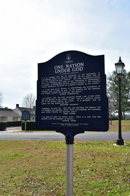
One Nation Under God Marker
1 ► Alabama, Shelby County, Montevallo — The Lucille Ryals Thompson Colonial Chapel / One Nation Under God —  |
| Near Montevallo Road (Alabama Route 119) 0.3 miles south of Alex Mill Road, on the right when traveling south. | |||
| 2 ► California, San Luis Obispo County, Atascadero — Your American Heritage Monument — |
| Near El Camino Real near Mercedes Avenue (California Route 41), on the right when traveling north. | |||
| 3 ► Connecticut, Capitol Region, South Windsor — Bissell Ferry — 1641 - 1917 — American Bicentennial 1776 - 1976 — |
| On Main Street at Ferry Lane, on the left when traveling north on Main Street. | |||
| 4 ► Connecticut, Capitol Region, Stafford, Stafford Springs — Stafford — |
| On River Road (Connecticut Route 32) near Main Street, on the right when traveling north. | |||
| 5 ► Connecticut, Southeastern Region, Norwich, Norwichtown — Norwichtown Green — |
| On East Town Street at Town Street, on the right when traveling north on East Town Street. | |||
| 6 ► Delaware, New Castle County, Newark, Pencader Hundred — Germans & German-Americans in The American War of Independence — 1776-1783 — |
| On Sunset Lake Road (Delaware Route 72). | |||
| 7 ► District of Columbia, Washington, Northeast Washington, Kingman Park — The White House — |
| Near Gales Street Northeast west of 18th Street Northeast, on the right when traveling east. | |||
| 8 ► District of Columbia, Washington, Northwest Washington, Cleveland Park — The Story of Rosedale — From Colonial Farm to Village Green — |
| On Newark Street Northwest at 35th Street Northwest, on the right when traveling west on Newark Street Northwest. | |||
| 9 ► District of Columbia, Washington, Northwest Washington, Georgetown — Crossroads of Georgetown — |
| On Wisconsin Avenue Northwest at M Street Northwest, on the left when traveling north on Wisconsin Avenue Northwest. | |||
| 10 ► District of Columbia, Washington, Northwest Washington, Georgetown — Presidential Visits to Old North — |
| Near Old North Way Northwest north of Library Walk Northwest, on the right when traveling north. | |||
| 11 ► District of Columbia, Washington, Northwest Washington, Judiciary Square — e.1 — Chief Justice John Marshall — Civil War to Civil Rights — Downtown Heritage Trail — |
| On Constitution Avenue Northwest (Alternate U.S. 1) west of 4th Street Northwest, on the right when traveling west. | |||
| 12 ► District of Columbia, Washington, Northwest Washington, Judiciary Square — John Marshall — John Marshall Park — |
| On Pennsylvania Avenue Northwest (Alternate U.S. 1) at 4th Street Northwest, on the right when traveling west on Pennsylvania Avenue Northwest. | |||
| 13 ► District of Columbia, Washington, Northwest Washington, The National Mall — A Memorial to the 56 Signers of the Declaration of Independence — A Gift From The American Revolution Bicentennial Administration — 1976 — |
| Near Constitution Avenue Northwest (U.S. 50) east of 19th Street Northwest, on the right when traveling east. | |||
| 14 ► District of Columbia, Washington, Southeast Washington, Capitol Hill — 1 — Edge of the Row — Tour of Duty — Barracks Row Heritage Trail — |
| On Pennsylvania Avenue Southeast east of 7th Street Southeast, on the right when traveling east. | |||
| 15 ► District of Columbia, Washington, Southeast Washington, Capitol Hill — 7 — Strike Up the Band — Tour of Duty — Barracks Row Heritage Trail — |
| On 8th Street Southeast at I Street Southeast, on the right when traveling south on 8th Street Southeast. | |||
| 16 ► District of Columbia, Washington, Southeast Washington, Navy Yard — Navy Department Library — |
| On Dahlgren Avenue Southeast south of Kidder Breese Street Southeast, on the left when traveling south. | |||
| 17 ► Florida, Volusia County, Ormond Beach — Mount Oswald Plantation — |
| Near no nearby street, on the left. | |||
| 18 ► Georgia, Chatham County, Savannah — Construction of Fort Jackson — |
| Near Fort Jackson Road. | |||
| 19 ► Georgia, Chatham County, Savannah, Historic District - North — 025-17B — Archibald Bulloch — |
| Near East Oglethorpe Ave. | |||
| 20 ► Georgia, Habersham County, Clarkesville — 068-7 — Summer Home of Joseph Habersham — ← — |
| On Hollywood Highway (Old U.S. 441) 0.1 miles north of New Liberty Road, on the left when traveling north. | |||
| 21 ► Illinois, DuPage County, Lisle, Lisle Township — A Few Thoughts on Democracy — |
| Near School Street east of Center Avenue, on the right when traveling east. | |||
| 22 ► Illinois, DuPage County, Wheaton — Adams Park — |
| On Main Street at Wesley Street, on the right when traveling north on Main Street. | |||
| 23 ► Illinois, Madison County, Alton — Freedom Shrine — |
| On Tavernier Way 0.2 miles south of West MacArthur Drive (Illinois Route 111/140), on the left when traveling south. | |||
| 24 ► Indiana, Allen County, Fort Wayne — Little Turtle — |
| Near South Barr Street. | |||
| 25 ► Indiana, Allen County, Fort Wayne, Spy Run — Meshekinnoquah — (Chief Little Turtle) — |
| On Lawton Place 0.1 miles east of Spy Run Avenue, on the right when traveling east. | |||
| 26 ► Indiana, Knox County, Vincennes — Indiana Territory — |
| On Park Street east of East Scott Street, on the right when traveling east. | |||
| 27 ► Maryland, Anne Arundel County, Annapolis — Commodore John Barry — Commission Number One United States Navy — |
| On Prince George Street west of Craig Street, on the right when traveling west. | |||
| 28 ► Maryland, Anne Arundel County, Annapolis — Congress Was Here — West Street — At the End of the Revolution — |
| On West Street (Maryland Route 450) west of Church Circle, on the right when traveling west. | |||
| 29 ► Maryland, Baltimore, Brooklyn — For God and Country — |
| On East Patapsco Avenue (Maryland Route 173) just east of 2nd Street ( Route 686), on the right when traveling west. | |||
| 30 ► Maryland, Baltimore, Carroll Park — Mount Clare, the Georgia Plantation — Gwynns Falls Trail — |
| Near Washington Boulevard, on the right when traveling south. | |||
| 31 ► Maryland, Baltimore, Locust Point Industrial Area — Colonel James McHenry — |
| Near Constellation Plaza 0.1 miles east of Wallace Street, on the right when traveling east. | |||
| 32 ► Maryland, Prince George's County, Hyattsville — The Declaration of Independence / President John F. Kennedy’s Inaugural Address — |
| On Toledo Road just west of America Boulevard, on the left when traveling west. | |||
| 33 ► Massachusetts, Barnstable County, Barnstable — James Otis Jr. — |
| On Main St (Massachusetts Route 6A) 0.1 miles east of Railroad Ave, on the right when traveling east. | |||
| 34 ► Massachusetts, Berkshire County, Lanesborough — Adams Overlook: A Town Tied to the Mountain — Mount Greylock State Reservation — |
| On Rockwell Road 8 miles north of Quarry Road, on the right when traveling north. | |||
| 35 ► Massachusetts, Norfolk County, Quincy — Abigail Adams — Adams National Historic Park — Quincy, Massachusetts — |
| On Hancock Street at Washington Street, on the left when traveling south on Hancock Street. | |||
| 36 ► Massachusetts, Norfolk County, Quincy — Adams National Historical Park — |
| On Franklin Street, on the right when traveling south. | |||
| 37 ► Massachusetts, Norfolk County, Quincy — John Adams — |
| On Burgin Pkwy at Dimmock Street, on the right when traveling north on Burgin Pkwy. | |||
| 38 ► Massachusetts, Norfolk County, Quincy — Old House — Adams National Historical Park — |
| On Adams Street, on the right when traveling west. | |||
| 39 ► Massachusetts, Norfolk County, Quincy — President John Adams and President John Quincy Adams Birthplaces — |
| On Franklin Street north of Presidents Avenue, on the left when traveling north. | |||
| 40 ► Massachusetts, Norfolk County, Quincy — United First Parish Church — |
| On Hancock Street at Washington Street, on the left when traveling south on Hancock Street. | |||
| 41 ► Massachusetts, Suffolk County, Boston, Charlestown — The Freedom Trail — |
| On Monument Square at Monument Ave. on Monument Square. | |||
| 42 ► Massachusetts, Suffolk County, Boston, Downtown — A Riot, the Massacre, and the Tea Party |
| On Tremont Street at Bromfield Street, on the left when traveling north on Tremont Street. Reported missing. | |||
| 43 ► Massachusetts, Suffolk County, Boston, Downtown — Abigail Adams — (1744-1818) — |
| On Washington Street at Milk Street, on the right when traveling north on Washington Street. | |||
| 44 ► Massachusetts, Suffolk County, Boston, Downtown — John Adams — (1735-1826) — |
| On Washington Street at Milk Street, on the right when traveling north on Washington Street. | |||
| 45 ► Massachusetts, Suffolk County, Boston, Downtown — The Freedom Trail — |
| On Devonshire Street at State Street, on the left when traveling north on Devonshire Street. | |||
| 46 ► Massachusetts, Suffolk County, Boston, Downtown — Tragic Events |
| Near Tremont Street at Bromfield Street, on the left when traveling north. Reported missing. | |||
| 47 ► Massachusetts, Suffolk County, Boston, North End — The Salutation Tavern / The Green Dragon Tavern — |
| Near Unity Street. | |||
| 48 ► Missouri, Clay County, North Kansas City — War Memorial — |
| On 23rd Avenue at Iron Street, on the left when traveling east on 23rd Avenue. | |||
| 49 ► Nebraska, Lancaster County, Lincoln — Thomas Jefferson — 1743 - 1826 — |
| On Pine Lake Road near South 30th Street. | |||
| 50 ► New Jersey, Gloucester County, National Park — The Aftermath — Red Bank Battlefield — |
| Near Hessian Road, on the right when traveling west. | |||
| 51 ► New Jersey, Mercer County, Princeton — John Witherspoon — 1723 - 1794 — |
| Near Nassau Street, on the right when traveling east. | |||
| 52 ► New Jersey, Mercer County, Trenton, Downtown — Trenton 1790–1834 — |
| Near West State Street east of Green Place. | |||
| 53 ► New Jersey, Mercer County, Trenton, South Trenton — From Federal City to State Capital — |
| Near New Jersey Route 29. | |||
| 54 ► New Jersey, Middlesex County, New Brunswick — New Brunswick — |
| On Albany Street (New Jersey Route 27) at Burnet Street ( Route 18), on the right when traveling west on Albany Street. | |||
| 55 ► New Jersey, Middlesex County, Perth Amboy — The Bluff: Witness to History — |
| On Water Street, on the left when traveling south. | |||
| 56 ► New Jersey, Morris County, Morristown — Thomas Paine — 1737 – 1809 — |
| On Washington Street (County Route 510) at Colonial Road, on the left when traveling west on Washington Street. | |||
| 57 ► New York, Richmond County, Staten Island, Tottenville — Billopp House — Landmarks of New York — |
| Near Satterlee Street, on the left when traveling north. | |||
| 58 ► New York, Richmond County, Staten Island, Tottenville — Conference House — Revolutionary War Heritage Trail — Heritage New York — |
| On Satterlee Street, on the left when traveling north. | |||
| 59 ► New York, Richmond County, Staten Island, Tottenville — The Conference House — |
| Near Satterlee Street, on the left when traveling north. | |||
| 60 ► North Carolina, Guilford County, Greensboro — Signers Monument — |
| On Guilford Courthouse Auto Tour Road at Old Battleground Road, on the left when traveling west on Guilford Courthouse Auto Tour Road. | |||
| 61 ► Ohio, Adams County, Manchester — 13-1 — Israel Donalson / Manchester Founders Cemetery — Member of the First Constitutional Convention of Ohio / 1791-1888 — |
| On 2nd Street (U.S. 52) west of Jack Roush Way, on the right when traveling west. | |||
| 62 ► Ohio, Coshocton County, Warsaw — 2-16 — Colonel William Simmons — 1757 - 1823 — |
| On Main Street (U.S. 36) at Plum Street, on the right when traveling west on Main Street. | |||
| 63 ► Ohio, Coshocton County, Warsaw — The Founding of Warsaw, Ohio — |
| On Main Street (U.S. 36) at Bridge street (Ohio Route 60), on the left when traveling west on Main Street. | |||
| 64 ► Ohio, Hamilton County, North Bend — Life At North Bend / President Harrison — William Henry Harrison Memorial Trail — |
| On Cliff Road 0.1 miles north of Bower Road, on the right when traveling north. | |||
| 65 ► Ohio, Highland County, Sinking Spring — Governor Charles Willing Byrd — |
| On Washington Street at Grant Ct., on the left when traveling west on Washington Street. | |||
| 66 ► Ohio, Jefferson County, Steubenville — This Old Federal Land Office — |
| Near South Third Street east of Adams Street. | |||
| 67 ► Ohio, Licking County, Johnstown — 17-45 — Johnstown Cemetery / War Veterans — |
| On Coshocton Street (U.S. 62) at Woodgate Drive, on the right when traveling west on Coshocton Street. | |||
| 68 ► Ohio, Lorain County, North Ridgeville — American Revolution — 1775 - 1783 — |
| On Bainbridge Road at Avon-Beldon Road (Ohio Route 83), on the right when traveling east on Bainbridge Road. | |||
| 69 ► Pennsylvania, Allegheny County, Homestead — Mary Harris "Mother" Jones — |
| On Amity Street near 9th Street. | |||
| 70 ► Pennsylvania, Bucks County, Doylestown, Plumstead Township — Marines — Established November 10, 1775 — |
| Near Easton Road. | |||
| 71 ► Pennsylvania, Bucks County, Quakertown — The Fries Rebellion of 1799 — |
| On Main Street at Broad Street (Pennsylvania Route 313), on the right when traveling south on Main Street. | |||
| 72 ► Pennsylvania, Cumberland County, Carlisle — Dr. Benjamin Rush — Founder of Dickinson College — |
| Near West High Street (U.S. 11) at North West Street. | |||
| 73 ► Pennsylvania, Lancaster County, Lancaster — Old Center Square (Penn Square) |
| On Queen Street at King Street, on the right when traveling north on Queen Street. Reported missing. | |||
| 74 ► Pennsylvania, Lehigh County, Bethlehem — Colonial Industrial Quarter — 1741 - 1800 — |
| On Main Street at Old York Road, on the left when traveling north on Main Street. | |||
| 75 ► Pennsylvania, Lehigh County, Bethlehem — Waterworks — 1762 — |
| Near Main Street. | |||
| 76 ► Pennsylvania, Northampton County, Bethlehem — The Old Chapel — |
| On Heckwelder Place, on the left when traveling south. | |||
| 77 ► Pennsylvania, Philadelphia County, Philadelphia, Center City East — History Lost & Found — The President's House — |
| On South 6th Street (County Road 2005) at Market Street (County Road 2004), on the left when traveling south on South 6th Street. | |||
| 78 ► Pennsylvania, Philadelphia County, Philadelphia, Center City East — Presidents Washington and Adams on Slavery — |
| On South 6th Street (County Road 2005) at Market Street (County Road 2004), on the left when traveling south on South 6th Street. | |||
| 79 ► Pennsylvania, Philadelphia County, Philadelphia, Frankford — The King's Highway — |
| On Frankford Avenue at Church Street, on the right when traveling north on Frankford Avenue. | |||
| 80 ► Pennsylvania, Philadelphia County, Philadelphia, Logan Square — Francisco de Miranda — Caracas, Venezuela - Cadiz, La Carraca Prison — 1750 - 1816 — |
| On Benjamin Franklin Parkway at Winter Street, on the right when traveling east on Benjamin Franklin Parkway. | |||
| 81 ► Pennsylvania, Philadelphia County, Philadelphia, Old City — City Tavern — Independence National Historical Park — National Park Service, U.S. Department of the Interior — |
| On South 2nd Street just north of Walnut Street (County Road 3006), on the right when traveling south. | |||
| 82 ► Pennsylvania, Philadelphia County, Philadelphia, Old City — Declaration of Independence — |
| On Chestnut Street at 3rd Street, on the right when traveling east on Chestnut Street. | |||
| 83 ► Pennsylvania, Philadelphia County, Philadelphia, Old City — National Funeral For President Washington — |
| On North 4th Street at Arch Street on North 4th Street. | |||
| 84 ► Pennsylvania, Philadelphia County, Philadelphia, Old City — 29 — The City Tavern — Independence Hall National Historical Park — |
| On South 2nd Street close to Walnut Street, on the left when traveling north. | |||
| 85 ► Pennsylvania, Philadelphia County, Philadelphia, Society Hill — Duffield and Old Pine's Role in the Revolutionary War — |
| Near Pine Street east of South 5th Street, on the right when traveling east. | |||
| 86 ► Pennsylvania, Philadelphia County, Philadelphia, Society Hill — Old St. Mary's — 1763 — |
| On 4th Street at St. James Place, on the right when traveling south on 4th Street. | |||
| 87 ► Pennsylvania, Philadelphia County, Philadelphia, Society Hill — Powel House — 1765 — |
| On South 3rd Street 0.1 miles Spruce Street, on the left when traveling north. | |||
| 88 ► Pennsylvania, Philadelphia County, Philadelphia, Washington Square West — Congregation of the Dead — |
| Near Walnut and 6th Streets. | |||
| 89 ► Pennsylvania, Philadelphia County, Philadelphia, William Penn Annex East — "We shall come to a civil war" |
| On Market Street at South Independence Mall West (6th Street), on the right when traveling east on Market Street. Reported permanently removed. | |||
| 90 ► Pennsylvania, Philadelphia County, Philadelphia, William Penn Annex East — Abigail Adams — 1744 - 1818 — Second First Lady of the United States 1797-1800 — |
| On South 6th Street (County Road 2005) at Market Street (County Road 2004), on the left when traveling south on South 6th Street. | |||
| 91 ► Pennsylvania, Philadelphia County, Philadelphia, William Penn Annex East — Celebrating Independence Throughout the Years — The President's House — |
| On South 6th Street (County Road 2005) at Market Street (County Road 2004), on the left when traveling south on South 6th Street. | |||
| 92 ► Pennsylvania, Philadelphia County, Philadelphia, William Penn Annex East — Commander in Chief — The Executive Branch — |
| On South 6th Street (County Road 2005) at Market Street (County Road 2004), on the left when traveling south on South 6th Street. | |||
| 93 ► Pennsylvania, Philadelphia County, Philadelphia, William Penn Annex East — In This Building — Sat the First Senate and the First House of Representatives — |
| On Chestnut Street, on the right when traveling east. | |||
| 94 ► Pennsylvania, Philadelphia County, Philadelphia, William Penn Annex East — John Adams — 1735 - 1826 — Second President of the United States 1797-1800 — |
| On South 6th Street (County Road 2005) at Market Street (County Road 2004), on the left when traveling south on South 6th Street. | |||
| 95 ► Pennsylvania, Philadelphia County, Philadelphia, William Penn Annex East — Old City Hall / Independence Hall / Congress Hall — |
| On Chestnut Street (County Road 3008) just west of South Independence Mall East (County Road 2003), on the right when traveling west. | |||
| 96 ► Pennsylvania, Philadelphia County, Philadelphia, William Penn Annex East — Selecting a President — The Executive Branch — |
| On South 6th Street (County Road 2005) at Market Street (County Road 2004), on the left when traveling south on South 6th Street. | |||
| 97 ► Pennsylvania, Philadelphia County, Philadelphia, William Penn Annex East — Signers Walk — |
| On Chestnut Street (County Road 3008) at South 6th Street, on the right when traveling west on Chestnut Street. | |||
| 98 ► Pennsylvania, Philadelphia County, Philadelphia, William Penn Annex East — State of the Union — The Executive Branch — |
| On South 6th Street (County Road 2005) at Market Street (County Road 2004), on the left when traveling south on South 6th Street. | |||
| 99 ► Pennsylvania, Philadelphia County, Philadelphia, William Penn Annex East — Suppressing the Opposition |
| On Market Street at South Independence Mall West (6th Street), on the right when traveling east on Market Street. Reported permanently removed. | |||
| 100 ► Pennsylvania, Philadelphia County, Philadelphia, William Penn Annex East — Taking the Oath — The Executive Branch — |
| Near South 6th Street (County Road 2005) at Market Street (County Road 2004), on the left when traveling south. | |||
137 entries matched your criteria. The first 100 are listed above. The final 37 ⊳