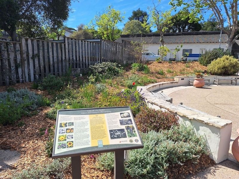
Welcome to the Casa del Oro Garden
The name of this garden means "House of Gold" and reflects the history of Old Monterey. The Joseph Boston Store, which anchors the garden, served as a storehouse for gold brought back by miners during the . . . — — Map (db m296410) HM
On Pacific Street south of West Franklin South, on the right when traveling south.
Built for an English blacksmith in 1840, and sold to Don Florencio Serrano, a schoolteacher, in 1846. The Monterey History & Art Association was founded here in 1931.
Lara-Soto Adobe * Up and to the right
Capitular Hall * Towards the Bay
Cell . . . — — Map (db m63312) HM
This hall started in 1847, completed in 1848, was named after its builder
Chaplain Walter Colton, U.S.N., 1787-1851
Congregational Minister, historian, author, and editor, who served as alcalde at Monterey from 28 July 1846 to 1 October . . . — — Map (db m63328) HM
Near Pacific Street, on the right when traveling south.
This Chestnut tree, form the lawn of the White House, was originally planted in front of Colton Hall on September 20, 1966 by First Lady, Lady Bird Johnson. It was later replanted in Friendly Plaza. — — Map (db m63327) HM
On Dutra Street at King Street, on the right when traveling north on Dutra Street.
In this building from September 1 to October 13, 1849 assembled the convention which drafted the constitution under which California was admitted to statehood, September 9, 1850. The forty-eight delegates met on the upper floor which ran the length . . . — — Map (db m196673) HM
Forty-eight men of diverse education and cultural backgrounds from throughout California converged upon Monterey in September in 1849 to frame a constitutional government for California. Working together as Californians, they created this . . . — — Map (db m63348) HM
This Circle Commemorates
Commodore John Drake Sloat, U.S.N.
In this City of Monterey
on 7 July 1846
he proclaimed California annexed to the United States
Tablet presented by the Commodore Sloat Chapter
Daughters of the American Revolution
7 . . . — — Map (db m226259) HM
Captain John B.R. Cooper arrived in Monterey in 1823 and quickly established itself as a leading merchant and ranchero. He married Encarnacion Vallejo and they moved to a town lot where they made their home in a one-story adobe. Overtime, Cooper . . . — — Map (db m296121) HM
On Munras Avenue south of Pearl Street, on the right when traveling south.
Behind these adobe walls, you will meet the John Rogers Cooper Family, who witnessed the changes in Monterey from its days as a capitol of Mexican California through statehood in 1850. Captain Cooper was from New England, immigrated to California . . . — — Map (db m63466) HM
On this site stood the first sardine cannery in Monterey, the Crescent Brand Sardine Company. The Cannery was founded by F.E. Booth, who was one of the original pioneers of the Monterey Sardine Industry.
The Monterey Commercial Property Owners . . . — — Map (db m63064) HM
Near Monterey Peninsula Recreational Trail, on the left when traveling north. Reported permanently removed.
The oldest government building in California. The American flag was raised at this site on July 7, 1846, claiming California as part of the United States.
First Brick House * Left at Wooden Flag Pole
Pacific House Museum * Along the Plaza
Cell . . . — — Map (db m66521) HM
On Monterey Peninsula Recreational Trail south of Custom House Plaza, on the right when traveling south.
Built in 1827 to collect custom duties, it is the oldest government building in California and State Landmark #1. The American flag was raised at this site on July 7th, 1846, claiming California as part of the United States of America.
. . . — — Map (db m296139) HM
Constructed in 1827 by the Mexican government to collect custom duties from foreign shipping, a principal revenue source when Monterey was the capital of Alta California, Mexico's northernmost province. Thomas O. Larkin, US consul to Alta . . . — — Map (db m82186) HM
On Church Street east of Figueroa Street, on the right when traveling east.
Lt. Colonel Juan Bautista De Anza by decree of Carlos III of Spain, lead an expedition to this site – the mission being to colonize the San Francisco Bay Area.
In the center of the marker is a circular motif, designed by Doris . . . — — Map (db m63230) HM
Near Del Monte Avenue, on the right when traveling west.
The first stop in Monterey for those traveling by train from San Francisco was the Del Monte station located between the bay and Hotel Del Monte. Only those passengers who were guests of the hotel detrained there. The foundation of this depot is . . . — — Map (db m63545) HM
On Pacific Street south of Artillary Street, on the right when traveling south.
On June 3, 1770, near this spot, Don Gaspar de Portolá, Soldier, Explorer, Patriot of Spain, founded the Presidio and settlement of Monterey. — — Map (db m135033) HM
Rosario Duarte introduced salmon trolling to Monterey Bay in 1878. His store was a popular local meeting place. Relocated in 1922 it became a dry goods business operated by Chinese merchant Louis Jang into the 1940’s. — — Map (db m63225) HM
The Row’s first canning operation
In 1902 Otosaburo Noda, a Japanese immigrant farmer, labor contractor and businessman, moved his abalone canning operation at Point Lobos to the rocky shoreline of Monterey. Noda and his partner Harry . . . — — Map (db m55193) HM
Near Olivier Street south of Scott Street, on the right when traveling south.
This bell was salvaged from the ruins of the 1906 Earthquake in San Francisco and hung at the McMenamin’s Mission Inn.
Robert C. Littlefield acquired it in 1961 and placed it in his garden home.
His widow Patricia donated it to the . . . — — Map (db m63222) HM
You are looking at the backyard of Ed Ricketts’s lab, Pacific Biological Laboratories, where Ricketts lived and worked during the 1930 and 1940s. He collected and preserved tide pool plants and animals and sold them to schools around the world. What . . . — — Map (db m55143) HM
Marine biologist, philosopher, writer, ecologist, and friend to many. Immortalized as “Doc” of John Steimbeck’s Cannery Row, the real man had a profound influence on the thinking of writers, artists, and scientists through his . . . — — Map (db m54904) HM
Site of a Spanish fort constructed in 1792 to protect the port and presidio of Monterey from invaders. This is one of only three such forts constructed by the Spanish in California. — — Map (db m63108) HM
This old Spanish fort began as eleven guns behind a crude parapet of logs overlooking the anchorage of Monterey Bay in 1972. The battery was strengthen and enlarged over the years and served as the principal fort in Monterey for both the Spanish and . . . — — Map (db m63107) HM
Author John Steinbeck won both the Pulitzer and Nobel prizes for literature. Many of his novels were set in the Monterey Bay area and the Salinas Valley. Ed Ricketts was both a friend and mentor, who influenced the writer’s ecological view of human . . . — — Map (db m55160) HM
On Pacific Street at Scott Street, on the left when traveling north on Pacific Street.
California's First Theatre.
Monterey State Historic Park,
a California State Park.
For more information, go to our website: www.parks.ca.gov/mshp — — Map (db m239972) HM
In 1927 cannery owner and fishing industry innovator Knut Hovden introduced new technologies to increase the catch and expedite the transfer of fish to the production line. By bringing purse seiner fishing boats (named for the type of nets they used . . . — — Map (db m55162) HM
First American fort in California. Built in 1846-47. Named in honor of Navy Captain William Mervine who directed the raising of the American flag over the Custom House in 1846. — — Map (db m63123) HM
On Hartnell Street at Polk Street on Hartnell Street.
Home of Gabriel de la Torre, public official of the Mexican and American period. Believed to be the first Federal Court in Monterey — — Map (db m63427) HM
Off the coast and beyond the breaking waves, giant kelp provides a lush home for marine life. Holding fast to the rocky bottom, these huge plants grow upward then spread their green-gold fronds across the water, creating a dense canopy of growth . . . — — Map (db m55161) HM
On 417 Alvarado Street north of Bonifacio Place, on the right when traveling north.
Built in 1926 and designed by Reid Brothers, architects of many California landmarks, this theatre was the first to show sound movies on the Monterey Peninsula.
Old Monterey Hotel * Across Street
Casa Sanchez * Across Street
See map on . . . — — Map (db m63518) HM
On Prescott Avenue at Wave Street on Prescott Avenue.
This simple bronze plaque honoring the work of John Steinbeck was sculptured in 1938 by William Gordon Huff. It was dedicated that same year by noted Western historian Dr. Charles L. Camp with all the unwavering oratorical profundity which . . . — — Map (db m54906) HM
On Pearl Street at Washington Street on Pearl Street.
Honoring Allen Griffin, 1893-1981, founder and publisher of the Monterey Peninsula Herald for his outstanding contributions to the City of Monterey.
Allen Griffin was the vital force in founding the History and Art Association, the . . . — — Map (db m63509) HM
On Alvarado Street, on the right when traveling north.
Founded in 1893, by Frank Hellam as the Climax Cigar Store, the shop later took Mr. Hellam's name. Hellam’s first tobacco shop relocated to 420 Main Street after he left his bootblack stand, which was adjacent to the Bohemia Saloon. He then . . . — — Map (db m219858) HM
Here June 3, 1770, landed Very Rev. Father Junipero Serra, O.S.F. and founded the following missions; San Diego, July 16, 1769, San Carlos Monterey, June 3, 1770, San Antonio de Padua, July 14, 1771, San Gabriel, Sept. 8, 1771, San Luis Obispo, . . . — — Map (db m63109) HM
Herrmann Hall
Named in Honor of
Rear Admiral Ernest E. Herrmann, USN
1896 - 1952
Superintendent
U. S. Naval Postgraduate School
1950 - 1952 — — Map (db m195596) HM
On Corporal Ewing Road north of Artillery Street, on the right when traveling north.
Hippolyte Bouchard is celebrated in Argentina as a hero and patriot and founder of the Argentine Navy--the equivalent of John Paul Jones in American history. Argentina placed this monument in celebration of his 200th . . . — — Map (db m296607) HM
On Jefferson Street at Alvarado Street on Jefferson Street.
Native of Monterey, Governor of California under Mexican rule December 20, 1836 - December 20,1842. During his administration the increasing influx of Americans, and the Russian settlement at Fort Ross, began to be regarded as serious problems. . . . — — Map (db m25055) HM
Ever since Thomas Edison’s movie camera captured those first quick, flickering moments of time, Hollywood has been coming to Monterey. More than 60 feature films have been shot in Monterey, and Cannery Row has been one of Hollywood’s favorite . . . — — Map (db m55194) HM
Named In Honor of Admiral Royal Eason Ingersoll, Commander In Chief United States Atlantic Fleet In World War II
His Father, Rear Admiral Royal Rodney Ingersoll
And His Son, Lieutenant Royal Rodney Ingersoll II, Killed On Board USS Hornet in . . . — — Map (db m208935) WM
On Monroe Street south of Franklin Street, on the right when traveling south.
This property - James W. Finch House - has been placed on the National Register of Historic Places by the United States Department of the Interior. — — Map (db m149114) HM
John “Bricky” Crivello, a key figure in the Monterey Fisherman’s Union for 67 years, was instrumental in the passage of Senate Bill 1213 which provided unemployment benefits to all California fishermen. Due to Bricky’s relentless . . . — — Map (db m68861) HM
Near Monterey Recreational Trail at Bruce Aris Way (Irving Avenue), on the right when traveling south.
The real neighborhood of John Steinbeck’s Cannery Row.
Real people and places in the neighborhood of Monterey’s old Ocean View Avenue inspired fictional characters and establishments in the mind of John Steinbeck. Published in 1945, his . . . — — Map (db m55081) HM
On Pierce Street south of West Franklin Street, on the right when traveling south.
In October 1944, John Steinbeck, his second wife Gwyn, and their infant son Thom returned to Monterey. On November 10, 1944 they moved into the Lara-Soto Adobe, “a house I have wanted since I was a little kid.”
Here he wrote The Pearl, a . . . — — Map (db m63314) HM
Quock Mui was born at Point Lobos in 1859 (lower left). Her parents were Cantonese fishermen who sailed to California by seagoing junk in 1851. Point Lobos was a thriving multicultural community in the later 19th century. Quock Mui had an aptitude . . . — — Map (db m55144) HM
On Fremont Street at Camino El Estero, on the right when traveling east on Fremont Street.
A native of Mexico de Anza left Tubac, Culiagan October 23, 1775 with a party of 240 together with horses, mules and beeves. Arrived Monterey March 10, 1776 with loss but one person. Journey of 1600 miles made under conditions of drought, snow and . . . — — Map (db m63566) HM
On Munras Avenue, on the left when traveling south.
Jules Simoneau
June 1819 – August 1908
Robert Louis Stevenson inscribed this message in the frontpiece of his book “The Strange Case of Dr. Jekyll and Mr. Hyde – but the case of Robert Louis Stevenson and Jules Simoneau, . . . — — Map (db m63451) HM
Near Church Streeet east of Figueroa Street, on the right when traveling east.
At Monterey, June 3rd
1770
the ceremony of taking possession
of California for Spain was enacted by
Father Junipero Serra
under the shade
of this tree. — — Map (db m63259) HM
Kalisa Moore, known as "Queen of Cannery Row," was born in Latvia and came to America after WWII. She bridged the eras, opening her gourmet restaurant when most of the canneries had closed.
Over the years "Kalisa's" became a bohemian coffee . . . — — Map (db m81817) HM
The building historically contained Edith's
Restaurant, the model for John Steinbeck's
La Ida Café and the character of Wide Ida in
The Novellas Cannery Row and Sweet Thursday — — Map (db m81954) HM
On Calle Principal at Jefferson Street Monterey, on the left when traveling south.
This house was constructed in 1834 by Thomas Oliver Larkin, the only United States Consul in California under Mexican rule. It has been used as a private residence, the United States Consulate, City Hall, and served as Headquarters of General . . . — — Map (db m82627) HM
On Calle Principal near Jefferson Street, on the left when traveling north.
Larkin House, American Consulate 1844-1846. Built in 1835 by Thomas Oliver Larkin, only U.S. Consul to California.
Monterey History & Art Assn.
Courtesy Thomson J. Hudson Memorial Fund — — Map (db m33495) HM
On Figueroa Street, on the right when traveling south.
The Railroad was critical to the development of the Salinas Valley's agriculture industry. As depicted in John Steinbeck's East of Eden, the advent of refrigerated rail meant that lettuce grown in the Salinas Valley could be transported coast to . . . — — Map (db m83322) HM
On Abrego Street north of Webster Street, on the left when traveling north.
Mary Corning Winslow Black, a noted Monterey artist designed and built this home in 1930.
This structure is an example of Spanish eclectic architecture and is included on the National Register of Historic Places. — — Map (db m63507) HM
On Van Buren Street north of Scott Street. Reported missing.
Formerly first Protestant church built in Monterey. Built in 1876
Monterey Art & History Assn.
Courtesy of Thomson J. Hudson
Memorial Fund — — Map (db m63092) HM
On Cannery Row, on the right when traveling north.
Portuguese whalers
From the California Gold Rush to nearly the turn of the century, Portuguese whalers launched boats from this beach and rowed them out into the bay to intercept whales migrating along the Monterey coastline. Once harpooned, . . . — — Map (db m55191) HM
Western terminal of the Monterey and Salinas Valley Railroad ending on 1,000 foot pier over Monterey Bay. First in operation October 1874 bringing grain from Salinas Valley to Monterey for ocean shipment to San Francisco.
Officers: Carr S. . . . — — Map (db m63309) HM
Recurring winter storms wreaked havoc on the Monterey fishing fleet every few years (top). On April 29, 1915, such a storm, with 60-mile-per-hour winds, destroyed or damaged nearly 50 boats. On Thanksgiving morning 1919, more than 93 vessels were . . . — — Map (db m55214) HM
It was over this building that the American flag was raised by Commodore John Drake Sloat, July 7, 1846, signalizing the passing of California from Mexican rule.
Restored through the efforts of the Native Sons of the Golden West with the . . . — — Map (db m95375) HM
Near Monterey Peninsula Recreational Trail, on the left when traveling north.
Constructed by the Mexican government during 1827 and 1841 to collect customs duties from foreign shipping when Monterey was the capital of this northern province, and customs duties were Alta California’s principal source of revenue. United States . . . — — Map (db m63307) HM
□ Look out upon these waters.
□ Their recorded history began when Juan Rodriguez Cabrillo sighted the "Bay of Pines" on Nov. 17, 1542.
□ Sebastian Viscaino was first to touch land Dec. 16, 1602. He claimed the land for . . . — — Map (db m30347) HM
For thousands of years prior to the arrival of Europeans in 1602, the Rumsien people fished Monterey Bay. These native people caught and used nearly every species of fish and shellfish found in the bay. Sea otters, sea lions and seals were dietary . . . — — Map (db m55192) HM
On Del Monte Avenue at Washington Street, on the right when traveling west on Del Monte Avenue.
This harbor is the home of....
Monterey's Commerical Fishing Fleet.
It once boasted the largest sardine fishing industry in the world, an industry that flourished until the late 1940's. Commercial fishing was pioneered and developed here by . . . — — Map (db m29859) HM
On Figueroa Street, on the right when traveling south.
The Monterey and Salinas Valley Railroad, established in 1874, was Monterey's first rail connection to the outside world. Purchased by Southern Pacific in 1879, passenger service soon began allowing the development of Monterey as a tourist . . . — — Map (db m83320) HM
Near Pacific Street, on the right when traveling south.
This "Moon Tree" is a Coast Redwood grown from a seed that in January 1971 was carried to the moon and brought back to earth by Major Stuart Roosa, Command Module Pilot for Apollo 14.
The seed was planted and nurtured into a seedling at the . . . — — Map (db m63500) HM
On Fisherman's Wharf at Monterey Bay Coastal Trail on Fisherman's Wharf.
Monterey's earliest pier of stone built in 1846 gave way to a commercial fishing wharf in the early 1900's when Monterey's multi-million dollar fishing industry was born. Despite many changes the wharf today retains the tone and flavor of the past . . . — — Map (db m30190) HM
On Cannery Row near Bruce Aris Way (Irving Avenue).
Doc, the legend
John Steinbeck used his close friend and collaborator, Edward Ricketts, as a model for the famous fictional character Doc. In the novels Cannery Row and Sweet Thursday, set in the 1930s and 1940s, the kindly Doc is a gentle, . . . — — Map (db m55142) HM
On Van Buren Street at Scott Street, on the right when traveling west on Van Buren Street.
Victorian home built in 1860 by whaling captain Manuel Perry and his wife Mary de Mello Silva, of Boston. The house remained in the family until 1963. Restored in 1967. — — Map (db m63220) HM
Dedicated to the memory of
Captain Robert Luis Pomerene
1924 - 1951
who died as a result of wounds received in
action 12 February 1951 in Korea. The Silver Star
was awarded posthumously to Captain Pomerene
for his actions that day. During . . . — — Map (db m308749) HM WM
Most of the wooden buildings on Presidio Hill below the Defense Language Institute complex were constructed from 1902 to 1906 by the 15th Infantry under the direction of Army Captain E.H. Plummer. The museum building was originally the post’s . . . — — Map (db m63125) HM
On University Circle at University Way, on the right on University Circle.
Rear Admiral Alan B. Shepard, Jr., United States Navy
November 18, 1924 - July 21, 1998
Naval Officer
Astronaut
First American in space 5, 1961
Commander, Apollo 14 January 31 to February 9, 1971
Walked on the moon - February 5, . . . — — Map (db m226352) HM
On Alvarado Street at Franklin Street, on the left when traveling north on Alvarado Street.
Finished in 1849 by Jacinto Rodriguez, member of California’s First Contitutional Convention. Later residence of Antonio Osio, Collector of the Port of Monterey under Governor Alvarado. — — Map (db m63519) HM
Erected in memory of Roger Stanley Fitch
Colonel United States Army, Retired. Founder and president 15 years of the Monterey History and Art Assn, LTD. Commanding Officer, Presidio of Monterey, 1928-1930, Fort Ord, 1941-1943. Member of Rough . . . — — Map (db m196676) HM
On Church Streeet at Figueroa Street, on the left when traveling west on Church Streeet.
The Royal Chapel of San Carlos de Borromeo, founded June 3, 1770, is the only remaining Presidio chapel in California.
Madariaga Adobe - Follow Church St. to Abrego
Cell Phone Tour (831) 718-9123 enter 710 — — Map (db m143524) HM
Near Church Streeet, on the left when traveling east.
No one has greater love than this, to lay down one’s life for one’s friends.
John 15:13
This San Carlos parish community gratefully remembers those who served in the Armed Forces of the United States during times of war and peace whose . . . — — Map (db m63504) WM
Edward F. Ricketts, owner-operator of Pacific Biological Laboratories, was described by a biographer as “a devoted and rational biologist who sought to uncover scientific truth.” A true renaissance man, Ricketts wrote extensively on a . . . — — Map (db m55145) HM
On Houston Street south of Pearl Street, on the left when traveling south.
Named after the “Cloth of Gold” rose bush, the Sherman Rose Inn was built circa 1941 as a private home. In 1934, J.C. Anthon enlarged the structure for the owners, Spiro and Jennie Catachi, using his signature Carmel stone. The building . . . — — Map (db m63479) HM
In the formative days of the Monterey fishing industry, the working boats were too small to carry both a crew and a catch. The fishermen towed a second boat called a “lighter,” which could hold 25 to 60 tons of sardines.
Since the . . . — — Map (db m55163) HM
On Bonifacio Place at Alvarado Street, on the right when traveling west on Bonifacio Place.
Location of the original “Sherman Rose Adobe” prior to its relocation to Mesa Road. Robert Louis Stevenson and William Tecumseh Sherman were guests here. — — Map (db m149867) HM
Site of original flagstaff
where the American flag was first raised
by
Commodore John Drake Sloat
on
July, 7th 1846
taking possession of California in the name of
the United States of America
Later ceded to America
under the Treaty . . . — — Map (db m63063) HM
Near Pearl Street near Munras Avenue, on the right when traveling east.
This plaza was once occupied by the restaurant of Jules Simoneau. In late 1879 young Scottish author Robert Louis Stevenson, the almost unknown, ate his meals hear nearly every day. He was staying in a small room at the nearby rooming house known . . . — — Map (db m63452) HM
On this spot on July 7, 1846, U.S. Marines and Sailors landed and raised the American flag over the Custom House which stands before you. Mexico and the United States were at war. American forces landing in Monterey claimed 600,000 square miles for . . . — — Map (db m59955) HM
1124 entries matched your criteria. Entries 101 through 200 are listed above. ⊲ Previous 100 — Next 100 ⊳