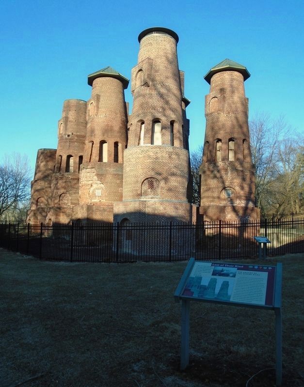
"For more than 100 years, the Saylor kilns have stood
as red-bricked sentinels, protecting Coplay's ties to the
cement industry that gave it life."
Sarah M. Wojcik
The Morning Call
THE ORIGINS OF THE SAYLOR KILNS . . . — — Map (db m267760) HM
In the Lehigh Valley rock suitable for hydraulic cement had been found near the present locations of Palmerton and Northampton when the Lehigh Canal was built. Mills to produce hydraulic cement were erected at these sites before the Civil War. It . . . — — Map (db m85451) HM
"The public ...wants heritage to be more active. They don't want
to see a plaque in a green park. They'd rather see more tangible
evidence of the past."
Professor Frank Matero
University of Pennsylvania
STABILIZATION
In . . . — — Map (db m267771) HM
The kilns are an iconic feature of the area, representative of the history of Coplay and the Lehigh Valley. Not only are they recognized for their social and historical importance in the community, but are nationally recognized on the National . . . — — Map (db m267779) HM
David Oliver Saylor was born on October 20, 1827 in Hanover Township, Lehigh County. In 1866, he organized the Coplay Cement Company for the manufacture of natural cement. He soon began experiments to produce Portland cement in 1871. He was granted . . . — — Map (db m85447) HM
Portland cement is essentially an artificial product. It is made by burning various minerals in a kiln at intensive heat to produce clinker. The upright dome kiln was the first type used in America. An improvement was the Schoefer vertical kiln with . . . — — Map (db m85448) HM
Called by the Indians "Macungie," or "feeding place of the bears." Area settlement begun in 1730's, and Shelter House was erected in 1734. Moravians established a "Gemein-Ort," or congregational village, and named it after the biblical town of . . . — — Map (db m156888) HM
The most famous of Pennsylvania's Indian quarries may be seen in the woods a few hundred yards southwest of here. Articles made from the jasper were carried by the Indians as far as New England. — — Map (db m85304) HM
The name Jasper Park remains a legacy to the labors of the Indian Clan of Chief Lappawinze of the area Lenape Indians who mined Jasper for their tools and arrow heads in the early 1700's in the Jasper quarry pits in this park. This monument . . . — — Map (db m85302) HM
On Tilghman Street at Mill Road/Windsor Drive, on the right when traveling west on Tilghman Street.
This industry was born in the Lehigh Valley. David O. Saylor first made portland cement at Coplay in 1871. Here also was the first use of the rotary kiln process commercially Nov. 8, 1889. This region has continued to lead in the industry. — — Map (db m29935) HM
On Church Street west of Main Street (Old U.S. 22), on the right when traveling west.
Dedicated to
those who served
their country
in the Armed Forces
of the United States
World War II
1941 — 1945
Korean Conflict
1950 — 1953 — — Map (db m111833) WM
On North Bishopthorpe Street at Ostrum Street, on the right when traveling north on North Bishopthorpe Street.
This talented author was born here July 22, 1898; died in New York March 13, 1943. “John Brown's Body” and his other poems and stories give vivid expression to the best in American spirit and tradition. — — Map (db m79675) HM
Near Ostrum Street just south of St. Luke's Place, on the right when traveling south.
Endowed in 1914 an opened in 1917, the Coxe Ward for Obstetrical Cases was one of the original one-story pavilions built at St. Luke's Hospital. It was funded by the widow and son of coal magnate Eckley B. Coxe. Built as the hospital's first . . . — — Map (db m225426) HM
On MacArthur Road (Route 145) 0.2 miles south of Mickley Pike, on the right when traveling south.
Founded 1762 by the noted colonial leader and jurist, William Allen. Known until 1834 as Northampton. Here the Liberty Bell was hidden in 1777, and Revolutionary wounded hospitalized. City incorporation, 1867. Long a textile and cement center. — — Map (db m29531) HM
On MacArthur Road (Pennsylvania Route 145) at Municipal Drive, on the right when traveling north on MacArthur Road.
In memory and honor of
all who have served
our country...
Duty • Honor • Courage • Sacrifice
Dedicated on Memorial Day May 29, 2017 — — Map (db m124163) WM
On River Drive (Pennsylvania Route 148) at River Drive, on the right when traveling north on River Drive.
“Our residents take pride and partner in their heritage—they understand the meaning of what we have and act to preserve it”
Delaware & Lehigh National Heritage Corridor and State Heritage Park, Management Action . . . — — Map (db m124051) HM
On River Drive (Pennsylvania Route 145) at River Street, on the right when traveling north on River Drive.
"Since most of the land was donated
to the railroads by the American public
in the first place, we believe it should
be returned to the public."
David Burwell, President,
Rails-to-Trails Conservancy, 1988
A . . . — — Map (db m124049) HM
A blockhouse, erected about 1756, stood 300 feet north of here. It was a place of refuge and defense against raids in French and Indian War days. Troops here guarded the area just south of the Blue Mountain, between the Schuylkill and Lehigh Rivers. — — Map (db m85706) HM
The first factory to produce blackboard and school slates common in U.S. classrooms opened nearby in 1847. Slate production peaked at over one million pieces early in the 20th century, leading to Slatington’s distinction as the nation’s top slate . . . — — Map (db m85565) HM
Slatington’s oldest surviving home was erected in 1824 by Nicholas Kern’s grandson George. The structure served as Slatington’s first hotel and was also a popular tavern. Currently this colonial period stone home is a private residence. — — Map (db m85654) HM
On West Church Street at 4th Street on West Church Street.
Slatington Borough Council purchased this property in 1888 to erect the town’s first fire station. Council decided the new building would house both the fire company and Slatington’s municipal offices. Dedicated on November 28, 1889, the building . . . — — Map (db m85685) HM
Slatington's oldest surviving structure was built circa 1807, by Nicholas Kern's grandson John. Nicholas Kern's Homestead once occupied the area in front of the barn. The barn's western portion was removed in 1894 to accommodate the opening of . . . — — Map (db m85655) HM
The areas first settler Nicholas Kern emigrated from the Palatinate area of Germany circa 1730 on board the ship Adventurer. Kern moved his family from south Whitehall Township after acquiring 700 acres in present day Slatington. The Kerns were . . . — — Map (db m85563) HM
Entrepreneur Asa Parker founded the Lehigh Valley Railroad (LVRR) in 1853 to more efficiently transport anthracite coal to market. A freight and passenger station was constructed on this site in 1862. The LVRR Slatedale Branch opened in 1870 for the . . . — — Map (db m85695) HM
This building was constructed in 1850 by John Remaley; whose grandfather Ambrose was an original settler to the area. Issued a liquor license in 1851 the building was originally called Remaley House, and later known as The Slatington Hotel. Edward . . . — — Map (db m85656) HM
On Main Street (Pennsylvania Route 873) north of Grove Street, on the right when traveling north.
Ambrose Remaley immigrated to America in 1749 on board the ship Lydia. He held land warrants for several hundred acres in the area currently known as Upper Slatington and Washington Township. Remaley settled in the area south of Washington Street, . . . — — Map (db m219277) HM
One of the largest slate-producing centers in the United States. Welsh slate entrepreneur William Roberts first sighted slate in 1844 near a local barn. He and other Welsh immigrants established and worked in numerous slate quarries in this region. . . . — — Map (db m85564) HM
A sawmill, built before 1755, and used as a station for troops at time of the French and Indian War, stood about 200 feet north of here. Known also as Kern’s Fort, its position on two pioneer roads gave it much military value. — — Map (db m85687) HM
Originally built by Indians, the Warrior’s path was a travel and trading route, which ran along the Lehigh River from Weissport’s Fort Allen to Easton. A spur trail traveled along the north side of Trout Creek. This spur trail continued up Factory . . . — — Map (db m85653) HM
The land that comprised Washington Township was separated from Heidelberg Township in 1847. The establishment of the Union Church led to the region’s settlement. John Peters, the area’s first landowner, was the namesake for the village known as . . . — — Map (db m85686) HM
On Grove Street, on the right when traveling west.
In 1919 a group of public-spirited citizens envisioned Victory Park as a memorial to WWI veterans. The existing park known as Kern's Grove included a ball field and woodlands. The community-funded park was dedicated on July 4, 1921 during a day long . . . — — Map (db m224242) HM
A substantial stone structure, used as a military post and as a refuge for settlers against attack, was nearby on the north bank of Coplay Creek. It was built in 1760 by Adam Deshler, a native of Switzerland. Remaining in his family for several . . . — — Map (db m85512) HM
Just west of here is the house built originally by John Peter Troxel in 1756 and acquired by Peter Steckel in 1768. It was restored in 1943 and is now owned and maintained as a museum by the Lehigh County Historical Society. — — Map (db m85513) HM
Just west of here is the house built originally by John Peter Troxel in 1756 and acquired by Peter Steckel in 1768. It was restored in 1943 and is now owned and maintained as a museum by the Lehigh County Historical Society. — — Map (db m85514) HM
On South Church Street at Park Street, on the right when traveling south on South Church Street.
In honor of the members
of the
Egypt Congregations
and
Community
who served in the
World War
☆☆ Killed in Action ☆☆
Clifford Gangeware • Edwin Miller • Harry Miller
☆ Died in Service . . . — — Map (db m124054) HM
On North Krocks Road south of Fred Jaindl Memorial Highway (U.S. 222), on the left when traveling south.
The story of farming in the Macungie area spans almost four hundred years, and far longer if the seasonal villages of native Indians are included. Agriculture was the most important industry in this area from the time of the first Europeans in . . . — — Map (db m252169) HM
On North Krocks Road 0.1 miles south of Fred Jaindl Memorial Highway (U.S. 222), on the right when traveling north.
Barns in this area, with their distinctive decorations, are widely admired. Nowhere else can you find as many fine barns of the type known as "Pennsylvania standard" barns. Their signature features are symmetrical rooflines and a forebay that . . . — — Map (db m252166) HM
On North Krocks Road just south of Fred Jaindl Memorial Highway (U.S. 222), on the right when traveling north.
Like any community with a long history, the Macungie area has changed a great deal over the years. By the end of the 1700s a few small businesses and industries had started. Some, such as mills, tanneries, harness shops and blacksmiths, provided . . . — — Map (db m252206) HM
On North Krocks Road north of Hamilton Boulevard, on the right when traveling north.
Churches
Almost all of the settlers here were Lutheran and Reformed (today's United Church of Christ), and a few were Moravian. The first religious observations were held by neighbors privately in each others' homes, or with an itinerant . . . — — Map (db m252210) HM
Near Hamilton Boulevard east of North Krocks Road, on the right when traveling west.
William Penn's 1681 charter from King Charles II of England authorized Penn to create counties and towns or townships in Pennsylvania. Philadelphia, Bucks, and Chester, all created in 1682, were the first three counties. If you were standing on . . . — — Map (db m252211) HM
Near Hamilton Boulevard 0.3 miles east of North Krocks Road, on the right when traveling west.
Almost all of the early settlers practiced mixed subsistence farming and had to be self-sufficient. They had brought seeds and, when possible, livestock with them on the trans-Atlantic voyage. The European farmers who came here, mostly Germans . . . — — Map (db m252510) HM
On Hamilton Boulevard west of Brookside Road, on the right when traveling west.
The Bortz Log House has been in the care of the Lower Macungie Township Historical Society since 1989, when it was moved to its present location in Wescosville Park. It was built in the late 1700s, and for many years it was one of only three . . . — — Map (db m252224) HM
Near Hamilton Boulevard west of Brookside Road, on the right when traveling west.
Before European settlement, the area that now includes Lower Macungie Township was inhabited by people who called themselves the Lenni-Lenape (Original People); English settlers called them the Delawares. The name "Macungie" is derived from a . . . — — Map (db m252221) HM
Near North Krocks Road south of Fred Jaindl Memorial Highway (U.S. 222), on the right when traveling north.
Jasper
Mining and quarrying have been important activities in the Macungie area for many hundreds of years. The first rock to be extracted from the ground to be used by humans was jasper, which the Lenape Indians used for their tools and . . . — — Map (db m252185) HM
On North Krocks Road 0.1 miles Fred Jaindl Memorial Highway (U.S. 222), on the right when traveling south.
Railroads
Railroads came early to the Lehigh Valley for only one reason: anthracite coal. For iron to be smelted productively in the modern furnaces of the 1840s on, enormous amounts of coal needed to be brought to the furnaces. The ore . . . — — Map (db m252229) HM
Roads on the 1876 map show where the first villages developed in Lower Macungie. They began as "crossroads settlements," often with just one public building such as an inn with food, rooms and stables.
Before we had shopping centers with big . . . — — Map (db m252230) HM
Near Hamilton Boulevard west of Brookside Road, on the right when traveling west.
While viewing a rain garden, a person only sees what is on the surface; a revolving seasonal display of both vibrant and subtle seasonal colors, as well as an assortment of leafy textures. This particular rain garden utilizes a combination of . . . — — Map (db m252225) HM
On South Church Street at Bridge Street, on the left when traveling south on South Church Street.
John Philip Boehm, 1734
John Henry Goetschius, 1736-1739
Peter Henry Dorsius, 1740
John Philip Boehm, 1741
John Conrad Wuert, 1742-1744
John Philip Boehm, 1745-1749
John Jacob Wissler, 1752-1754
Philip Jacob Michael, 1755-1763 . . . — — Map (db m124053) HM
On Reliance Street west of Ironton Rail-Trail, on the left when traveling west.
This Pennsylvania German farmhouse was constructed in 1756 by John Peter Troxell, an immigrant from Germany in search of a better life. When the structure was built, twenty years before the Declaration of Independence was signed, this farm sat on . . . — — Map (db m245026) HM
On Sullivan Street south of Market Street ( Route 512), on the right when traveling south.
Bangor Little League Field House
Dedicated in memory of
William D. Scott, Jr.
Centennial Year 1975
Charter Members
Officers
Marshall Pysher • John Linaberry
Jesse Mackintosh • Louis Trigiani
Managers
Elwood Parsons . . . — — Map (db m183177) HM
On Broadway east of 5th Street, on the right when traveling east.
For over 40 years, the Welsh community of the Slate Belt held an event on the property of this church known as Bangor Welsh Day. Beginning in 1930, the event brought thousands of visitors to the town from throughout the northeast U.S. for . . . — — Map (db m182197) HM
On 1st Street (Pennsylvania Route 191) at Market Street ( Route 512), on the left when traveling north on 1st Street.
First Trustees — October 28, 1898
Rev. John Williams
William O. Pritchard • Robert R. Hughes
Richard W. Jones • John Roberts • Joseph Jones
———————————————————
Present Trustees
President Thomas R. Hughes
Vice President John W. . . . — — Map (db m183254) HM
On 1st Street (Pennsylvania Route 191) north of Market Street ( Route 512), on the left when traveling north.
In honor and memory
of all, from the
Slate Belt Area,
who served for our
freedoms in the Civil War.
They will never be
forgotten.
Dane DiFebo Troop 14 Eagle Scout Project 2004 — — Map (db m183256) WM
On Broadway at Main Street, on the right when traveling east on Broadway.
In commemoration of the Homefront Magazine founded and published by J. Horace and Mona Strunk at 118 Pa. Ave., Bangor. This quality monthly non-profit endeavor carried news, pictures, and letters from the folks at home to their men and women in . . . — — Map (db m182192) HM
On Broadway east of 5th Street, on the right when traveling west.
(Location of graves, and other pertinent information,
maintained in Trinity Lutheran Church Cemetery records)
Abraham Ackerman • Lydia Ackerman • Elizabeth Ackerman
David Ackerman • Mariah Ackerman • Henry H Ackerman
Isaac D. Ackerman • . . . — — Map (db m182249) HM
On Broadway east of 5th Street, on the right when traveling east.
Upon this site was built the first church in Bangor. It served our worthy ancestry as church and school until 1883 when its last pastor, David Henning, who is interred in the adjacent cemetery, deeded the property to the Lutherans. God has been . . . — — Map (db m182196) HM
On Broadway east of Murray Street, on the left when traveling east.
This mural was inspired by the people and places of Bangor, PA circa 1912.
Sources include period photos from the Slate Belt Heritage Center, citizens of Bangor, and clothing from the collection of Janet Wilson.
1. The Muralist, James . . . — — Map (db m182244) HM
On North 1st Street (State Road 191) at Market Street (State Road 512), on the left when traveling north on North 1st Street.
Robert M. Jones of Wales, who came here in 1848 as an immigrant, began the slate quarrying industry. The region became a major world center for slate. From here came slate for roofs and old-time school slates and pencils. — — Map (db m29697) HM
On South Delaware Drive (Pennsylvania Route 611) at Howell Road, on the left when traveling north on South Delaware Drive.
The log house occupied by the Presbyterian missioner to the Indians in 1744 was a short distance away on the side road. It was here the youthful zealot wrote part of his famed journal. — — Map (db m29617) HM
Congressman; Governor for two terms, 1829-35, was born on a nearby farm on Aug. 12, 1777. His fame rests on his support of the Free School Act of 1834, foundation of the public school system of the State. — — Map (db m86252) HM
On Cemetery Lane east of Valley View Road, on the left when traveling east.
For many years this school house bell
called students to class in the one room
school house located just a short distance
to the west of our present location. It was
purchased by
the Rev. George Laubach when the school
was closed around . . . — — Map (db m274056) HM
On Sullivan Trail (Pennsylvania Route 191) 0.1 miles south of Bangor Road ( Route 191), on the left when traveling south.
“Our residents take pride and partner in their heritage—they understand the meaning of what we have and act to preserve it”
Delaware & Lehigh National Heritage Corridor and State Heritage Park, Management Action Plan.
Welcome to . . . — — Map (db m268093) HM
Near Sullivan Trail (Pennsylvania Route 191) 0.1 miles south of Bangor Road ( Route 191), on the left when traveling south.
"Since most of the land was donated to the railroads by the American public
in the first place, we believe it should be returned to the public."
David Burwell, President,
Rails-to-Trails Conservancy, 1988
A Well-Worn Path The . . . — — Map (db m268094) HM
On 3rd Street at Pierce Street, on the left when traveling east on 3rd Street.
Transported scrap metal to steel making furnaces
Who made it?
Built by Whitcomb Locomotive Company, Rochelle, IL, 1941
Who used it?
Electric Furnace Melt Shop, Bethlehem Steel, Bethlehem, PA
What did it . . . — — Map (db m250959) HM
On East 3rd Street (Pennsylvania Route 412) at Pierce Street, on the right when traveling east on East 3rd Street.
In February, 1910, over 9,000 steelworkers went on strike over wages, overtime, and work conditions. A striker was shot and killed here during hostilities that ensued. The subsequent federal investigation substantiated workers' claims and . . . — — Map (db m298530) HM
The sprawling steel plant once occupied close to 1800 acres between South Bethlehem and the Lehigh River. After it shut down, the company took on a major environmental clean-up, leaving the site safe for future use. In the years that followed, . . . — — Map (db m114370) HM
The streets that stretch up from the steel plant make up South Bethlehem. Over the decades, this community grew along with Bethlehem Steel's growing workforce. Generations of workers lived, shopped, attended school and church, played sports, . . . — — Map (db m113779) HM
Look down at the walkway on the Trestle. Some workers signed their names in steel, welding the letters on the deck. Working at the Steel meant you were part of something important: a huge industry that served the needs of a growing . . . — — Map (db m113920) HM
On Sand Island Trail 0.2 miles east of Main Street, on the right when traveling east.
The Locks Are Key
Engineers on the Delaware and Lehigh canals installed over 70 locks to raise and lower canal boats onto stretches of level water. Although there were variations between individual locks, the process of "locking through" . . . — — Map (db m157402) HM
On 3rd Street at Pierce Street, on the left when traveling east on 3rd Street.
Created pressurized air to run machines
Who made it?
Ingersoll Rand, Phillipsburg, NJ, 1926
Who used it?
Scotty's Fashions, Lehighton, PA
What did it do?
Driven by belts from a 40 horsepower . . . — — Map (db m250760) HM
On 1st Street at Founders Way, on the left when traveling west on 1st Street.
Air Products, founded in 1940, revolutionized the supply of industrial gases on the novel concept of building a plant next to a steel mill and piping oxygen directly to the customer. That transformative idea was reflected in the "A" of Air . . . — — Map (db m111838) HM
On Church Street, on the right when traveling west.
An early Germanic type of building; erected in 1745. Used first as the Family House. Girls' School, 1749. Bell, still in use, was cast in Bethlehem. Turret had first town clock, 1746. Weathervane is the church seal in metal. . . . — — Map (db m27109) HM
On 3rd Street at Pierce Street, on the left when traveling east on 3rd Street.
Straightened or formed curves in armor plate for battleships
Who made it?
Built by Bethlehem Iron Company from the plans of
Sir Joseph Whitworth & Co., Manchester, England, 1890
Who used it?
Bethlehem Iron . . . — — Map (db m250947) HM
Across all its facilities, Bethlehem Steel produced over 1 billion tons of steel between 1905 and 1999-that's over 12,000 Golden Gate Bridges worth of material! A high quality of steel, dependent upon rigorous testing during the many . . . — — Map (db m113800) HM
On Fillmore Street at East 3rd Street ( Route 412), on the right when traveling north on Fillmore Street.
Headquartered here, it was one of the most important iron and steel manufacturers in the nation. In 1863, Bethlehem Iron Co. began producing railroad rails. Steel manufacturing began in 1873 with armor plate and guns forged for the US Navy. The . . . — — Map (db m79612) HM
Look around you, these five blast furnaces were the heart of the plant for many decades. Ordinarily up to three of the five furnaces would be operating at one time. They ran continuously-night and day, seven days a week-and required constant . . . — — Map (db m113751) HM
On Church Street at Main Street, on the left when traveling west on Church Street.
Built 1748 by Moravians as house for single men. Early industry center: bell foundry, silkworm culture, other crafts and trades. Military hospital in Revolution. Girls' school from 1815. Now part of Moravian College and a museum. — — Map (db m26904) HM
On West Packer Avenue at Vine Street on West Packer Avenue.
Author & historian. Her works include books on Oliver Wendell Holmes, Jr. “Yankee from Olympus”, Sir Edward Coke “Lion and the Throne”, & the U.S. Constitution “Miracle at Philadelphia”. She lived here during her . . . — — Map (db m79688) HM
On Church Street at Heckewelder Place, on the right when traveling west on Church Street.
The annual festivals of the Bach Choir
of Bethlehem were initiated on
March 27, 1900 by the first American
performance of the “Mass in B Minor”
of Johann Sebastian Bach. — — Map (db m27140) HM
On 3rd Street at Pierce Street, on the left when traveling east on 3rd Street.
Loaded open hearth and electric arc furnaces with scrap metal to be melted down into steel
Who made it?
Wellman Engineering Co., circa early 1940's
Who used it?
Built for use in the Bethlehem Plant's No. 1 Open . . . — — Map (db m250950) HM
On West 3rd Street west of Seneca Street, on the right when traveling west.
American industrialist and pioneer of the US steel industry. Schwab established Bethlehem Steel Corporation in 1904. By World War I, it was among the largest steel producers in the world and a major contributor to the war effort. Schwab's South . . . — — Map (db m79657) HM
On D&L Trail / Sand Island Trail 0.1 miles east of Main Street, on the left when traveling west.
"We used to trade a lot along the canal. People who had vegetables and things. We'd give them coal and they'd give us cabbages, tomatoes and things like that. There were lock tenders whose wives made good bread. We'd give them coal . . . — — Map (db m157396) HM
In memory
of the soldiers of the
Continental Army
who suffered and died in this
building used as a military hospital
from
Dec. 1776 to April 1777 and
Sept. 1777 to April 1778 — — Map (db m27115) HM
On Riverside Drive 0.1 miles north of West 3rd Street (County Road 412), on the right when traveling west.
A two-story log inn, built here in 1745, was Bethlehem's first public house. Located near the ferry that crossed the Lehigh River, it was visited by famous political and military leaders of the era. A bridge replaced the ferry, 1794, and the inn . . . — — Map (db m29831) HM
462 entries matched your criteria. Entries 101 through 200 are listed above. ⊲ Previous 100 — Next 100 ⊳