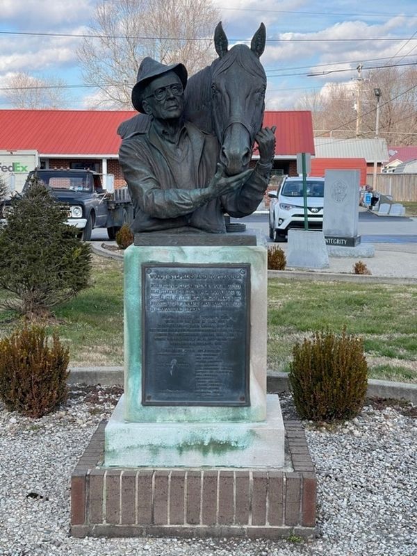
Born Woodford Cefis Stephens in Powell County near Stanton on Sept. 1, 1913. Woody rose to become one of the most talked about, most honored, and winningest race horse trainer’s in thoroughbred history. Major events in Woody’s life; voted into the . . . — — Map (db m73871) HM
Born November 10, 1926, Livingston, Kentucky - Died September 1, 1950, Yongsan Village, Korea.
Drafted in the U.S. Army during the Korean War, PFC David M. Smith died in battle when he sacrificed his life to save his comrades-in-arms when he fell . . . — — Map (db m103715) WM
Daniel Boone’s Trace
Pioneer trail marker by Daniel Boone in 1775 brought early settlers through the Cumberland Gap to Fort Boone (Boonesboro). This trace suitable for horses and walking, followed creeks, Indian hunting paths and buffalo . . . — — Map (db m218393) HM
PFC David M. Smith Homesite of this Congressional Medal of Honor winner, born in Livingston, Ky., Nov. 10, 1926. Church built here, 1974. Smith served with the U.S. Army, Co. E, 9th Inf. Regt., 2d Inf. Div., during Korean Conflict. The honor . . . — — Map (db m103713) HM
Originally the Livingston Hotel, this impressive structure was built near what was then the main road and wooden bridge that crossed over Roundstone Creek. The hotel had a dining room and offered packaged meals to travelers on the trains. It . . . — — Map (db m103711) HM
Side A
This trace was named for Henry
Skaggs, a Long Hunter. Many
famous pioneers, including John
Floyd, Benjamin Logan, and William
Whitely, traveled over it. On
Oct. 21, 1861, the first Kentucky
Civil War battle occurred near
here . . . — — Map (db m84454) HM
August 23, 1862, 650 cavalry of Gen. E. Kirby Smith's invading CSA army routed small Federal force under Col. Leonidas Metcalfe here on way to seize Ky., cooperating with CSA army under Gen. Braxton Bragg. Central Ky. captured, but plans to take . . . — — Map (db m230198) HM
The 96-mile stretch of road from
Crab Orchard to Cumberland Gap was
known as Boone Way. Col. James
Maret, an early advocate of road
improvement, was responsible for
cutting of roadbed and it’s first
paving. As L&N railroad agent and
telegraph . . . — — Map (db m84508) HM
Bryant Building
This two-story building, built in 1912, began as the Bryant building. Brothers Oscar, Emmitt and Logan Bryant were the original owners and they sold tractors and farm machinery from the rear garage. The front windows of the . . . — — Map (db m244578) HM
Current residents remember the home of C.C. Williams that was lost in an unfortunate and devastating fire in 2005. Located on this parcel of land at the intersection of Main and Richmond, this prominent home with its wrap around porch, was the home . . . — — Map (db m244604) HM
In 1810 a new county, Rockcastle, was created out of primarily Lincoln and Madison counties. The area's justices of the peace were told to "meet at the dwelling-house of Stephen Langford" on the first Monday in April to organize the county . . . — — Map (db m244588) HM
Born in Garrard Co., Maret came
here in 1877. He established this
county’s first telephone exchange
and newspaper; was town clerk for
25 years. Maret served as executive
secretary of Kentucky’s Good Roads
Association, and in 1929 published
a . . . — — Map (db m84509) HM
The Joplin Hotel, constructed on this site before 1862, was the second brick building in Rockcastle County, the first building to have a tin roof, and the home of the county’s first telegraph office at the beginning of the Civil War. By 1908 the . . . — — Map (db m87911) HM
The Elkin Hotel structure stood on this site from the time of its construction around 1820 until its demolition in 1905. Originally built by Rueben Elkin, it was a two-story wooden clapboard building with a wood shingled roof. This was Mt. Vernon’s . . . — — Map (db m103719) HM
Fritz Krueger and his family emigrated from Germany to America in 1885. The family settled
in Mt. Vernon in 1891 and quickly Fritz became a prominent businessman and contractor.
At this site. Krueger constructed a building with bricks from his Mt. . . . — — Map (db m244583) HM
A Rockcastle County post of the national GAR held meetings in this building for decades until the last of the local Union veterans became too old or died. It was a national fraternal organization composed of veterans of the Union’s army, navy, and . . . — — Map (db m103723) HM
Pioneers referred to our area as Langford's Station or Langford's until city lots were laid out by Stephen in 1810. He donated the property that became known as Mount Vernon, county seat for Rockcastle. Americans were very patriotic and when the . . . — — Map (db m244585) HM
Longhunters
Prior to settlers entering Kentucky, there were men that came through the Cumberland Gap in search of hides / furs. These men became known as Longhunters because they would leave their homes and hunt for extended periods of time - . . . — — Map (db m244587) HM
The mountains of Rockcastle County were the last challenge for pioneers to face before reaching the level land of the bluegrass area. In the 1700's there were three routes in the county traveled by thousands of pioneers by 1790.
The first was . . . — — Map (db m244601) HM
Side A
Rockcastle Co.
War Memorial
Side B
World War I
(list of 19 names)
Side C
World War II
(list of 81 names)
Side D
Korean War
(list of 5 names)
Congressional Medal of Honor Winner
Viet Nam . . . — — Map (db m85410) WM
The 52nd Kentucky county. Created
out of Knox, Lincoln, Madison,
Pulaski counties. Isaac Lindsey,
who came here with a hunting party
in 1767, observed a lone rock which
resembled an ancient castle. From
this the river was named, later
the . . . — — Map (db m84512) HM
Spout Spring became an important gathering place for pioneers in the late 1700's because it furnished clean drinking water. The area was settled by founder Stephen Langford in 1790. Spout Spring which continues to run and two other springs no longer . . . — — Map (db m244577) HM
Mount Vernon is unique - it's the only modern town in the "wilderness" that emerged from a frontier outpost. Originally called Langford's Station, it was the creation of Stephen Langford, his son Benjamin (with wife Nancy Peyton), Elizabeth Brown, . . . — — Map (db m244603) HM
Around 1870 the old section house, a frame shed that provided security and weather protection for track maintenance tools, stood on this property. It was owned by the L&N Railroad. During that time, the depot and retail businesses surrounded the . . . — — Map (db m244581) HM
The first county formed by first Assembly of Kentucky, 1792. Named for Geo. Washington. Springfield, county seat, laid off, 1793, by Matthew Walton; veteran of War of Revolution, legislator. Courthouse built in 1816, oldest used as such in state . . . — — Map (db m121609) HM
John Hunt Morgan and his men arrived in Mackville on Saturday evening, July 12, 1862, following raids on Lebanon and Springfield. Shortly after their arrival a skirmish ensued between Morgan’s men and the Home Guard. The Home Guard took two . . . — — Map (db m152653) HM
One of the ablest orators, lawyers, lawmakers in early Ky. Moved to Nelson, now Washington Co., with parents. In 1808, he settled at Bardstown where his career earned him the title "last of race of giants." Member state legislature 9 yrs.; U.S. . . . — — Map (db m99432) HM
On the morning of July 5, 1863, Springfield awoke to the roar of cannon fire coming from Lebanon. That afternoon John Hunt Morgan’s column reached Springfield with over 300 Federal prisoners in tow.
Young Will McChord, then eleven, described . . . — — Map (db m99436) HM
Captain Abraham Lincoln, Sr,, grandfather of the 16th president, was
killed near his home by Lincoln's Run in Washington County April
1788 by a Native American. Latitude: 37.77081 Longitude: -85.21509.
He was buried in The Pioneer Cemetery . . . — — Map (db m250705) HM
This home was built by J.A. Seay circa 1882 when Andrew Cunningham lived here with his wife Elizabeth Bullock. Mr. Cunningham operated the dry goods store in Springfield.
The house was purchased in 1932, from the Springfield State Bank, by George . . . — — Map (db m121749) HM
When building lots were first surveyed for Springfield’s downtown, this location was much sought after because of its proximity to the courthouse. William Pile had a storehouse here in 1797, and John Lancaster owned the lot in 1813. Prior to 1876, . . . — — Map (db m121745) HM
Home of Elizabeth Madox Roberts, novelist, poet. Best known works, Time of Man, 1926, Great Meadow, 1930, both written here. The latter also published in England, Germany, Spain; made into successful movie. She wrote all of her novels, . . . — — Map (db m121590) HM
Built in 1851, by Wm. S. Davison, son of the town's first merchant. Typical Italianate style employed by Blue Grass architect Lewinski. Purchased by Hugh McElroy, 1858. In early Oct., 1862, Union forces moved through Springfield before Battle of . . . — — Map (db m121596) HM
Grundy gained prominence in Ky. as a celebrated criminal lawyer and political leader. He practiced law on Main St., Springfield, took part in 2nd Constitutional Conv., served Washington County in legislature (1800-02); Nelson Co. (18004-06). Became . . . — — Map (db m283423) HM
Grundy Plantation
Settled by George and Elizabeth Grundy in 1780 after fleeing war-torn Berkeley Co., Va. This wilderness frontier of Va., then called Kaintuckee, became a state in 1792. Son Samuel stayed on the farm and expanded it. Another . . . — — Map (db m121607) HM
Built on part of Matthew Walton's land used to establish Springfield. Deeded, 1817, to John Thompson by town trustees. Bought same year by John Bainbridge, who operated a tavern there. Sold in 1830 to D.H. Spears, noted silversmith. Later owned by . . . — — Map (db m99456) HM
Thomas Lincoln and Nancy Hanks took up housekeeping here on September 21, 1805. Built about 1780 by Richard Berry, Sr., the cabin provided temporary lodging when Berry acquired 600 acres at Beechland.
Thomas and Nancy's first child, Nancy, died . . . — — Map (db m250706) HM
Louis Sansbury (1806-1861), a black slave, owned by George Sansbury, was left with keys to Sansbury’s hotel to watch over his business. In 1833, left virtually alone with the sick and dying, Sansbury fed and treated the many cholera sufferers . . . — — Map (db m121747) HM
On June 12, 1806, he performed the marriage of Thomas Lincoln and Nancy Hanks, who, in 1809, became the parents of Abraham Lincoln, 16th President of the U.S. Head, born in Maryland in 1768, "came a-preaching" to Kentucky in 1798. Cabinet maker, . . . — — Map (db m99457) HM
Service Battery 623 F.A. BN.
Kentucky National Guard
Ordered Into Service
Jan. 23, 1951
Sailed for Korea Dec. 4, 1951
2nd Korean Winter
Korea – Summer / fall 1952
3rd Korean Winter
Korea – Summer 1953
Men from Washington and . . . — — Map (db m121744) WM
On this site in _____ stood the little office of the Clerk of the Washington County Sourt where Thomas Lincoln gave bond and secured a license to marry Nancy Hanks. The wedding took place at Beechland this county on June ____ — — Map (db m121746) HM
The Lincoln Cabin is a replica of the log cabin in which the President’s grandmother, Bersheba, raised her children.
Thomas Lincoln, father of the President, lived here until he was 25 years old. The cabin is furnished in the pioneer style and . . . — — Map (db m46307) HM
The certified marriage bond of Thomas Lincoln to Nancy Hanks, parents of Abraham Lincoln, is on file here in Washington Co. Courthouse. Here also preserved is full account of the wedding. Lincoln Homestead State Park, seven miles north, now marks . . . — — Map (db m121577) HM
Pioneer Spirit
The westward movement was an enticement felt by many nineteenth century families, and the Lincolns were in the heart of it. A friend of the family was the infamous frontiersman Daniel Boone, and it has been reasoned that . . . — — Map (db m46249) HM
(obverse)
Thomas and Nancy Hanks Lincoln, the parents of future president Abraham Lincoln, were married near here on June 12, 1806. Shortly after their wedding, the couple moved to Elizabethtown, where their daughter, Sarah, was born. The . . . — — Map (db m46250) HM
On Tuesday morning, December 30, thirty-nine hundred Confederate cavalrymen led by John Hunt Morgan left Bardstown, making every effort to beat the Union forces to the Cumberland River crossing at Burkesville. Their progress was hampered by a cold . . . — — Map (db m99437) HM
The covered bridge over Little Beech Fork is 211 feet long and 16 feet wide. It utilizes the Burr truss design and is one of the longest multi-spans in Ky. The contractors were H. I. and William F. Barnes of Mount Washington. Original cost of . . . — — Map (db m121604) HM
Thomas Lincoln
Thomas Lincoln was born on January 7, 1778, in Rockingham County, Virginia, to Captain Abraham and Bathsheba Lincoln. He was the youngest of three sons and the fourth of five children. The Lincoln family migrated from . . . — — Map (db m46311) HM
CSA Gen. John H. Morgan's cavalry moved thru Springfield on raids July 12 and December 30, 1862. On third raid, into Ohio, after battle of Lebanon, July 5 1863, Union prisoners brought here but paroled to speed CSA movement. Confederate invasion . . . — — Map (db m99438) HM
Cradle and Mother House of the Dominican Sisters in U.S. First settlement at St. Rose Farm, 1822. Known as St. Magdalen Academy from 1823 to 1851. Renamed, 1851, St. Catharine of Sienna. Mother Angela Sansbury, O.P., and Rev. S. T. Wilson, O.P., . . . — — Map (db m170101) HM
Founded, 1806, by Fr. Fenwick from Maryland. First Dominican religious house and second oldest priory in the U.S. Site of first Catholic college west of Alleghenies, 1807. St. Thomas School here, 1809-28. Jefferson Davis, later President of . . . — — Map (db m121601) HM
Sarah Mitchell Thompson, first cousin and best friend of Nancy Hanks Lincoln, mother of President Lincoln, is buried here at Pleasant Grove Cemetery. Abducted by Native Americans near Crab Orchard, Kentucky, she was released from captivity in . . . — — Map (db m250708) HM
Thomas Lincoln proposed to Nancy Hanks in this house, originally located on Beech Creek about one mile from here. At the time, Nancy was living with her cousin, Francis Berry, and his family.
Lucy Shipley Hanks and her daughter, Nancy, . . . — — Map (db m46270) HM
Mordecai Lincoln, uncle to President Abraham Lincoln, lived in this house from around 1797 to 1811.
His father, Captain Abraham Lincoln, the grandfather and namesake of the future president, came to Jefferson County, Virginia, in 1782. In . . . — — Map (db m46243) HM
The Lincoln Cabin is a replica of the cabin in which President Abraham Lincoln’s grandmother Bersheba Lincoln, lived and raised her children after the death of her husband, Abraham.
In the spring of 1786, Abraham and Bersheba Lincoln were . . . — — Map (db m46305) HM
The Lincoln Legacy
Ca. 1782 The Lincoln, Hanks, Berry and Shipley families begin migrating to the Beech Fork in Kentucky.
1806, June 12 Nancy Hanks and Thomas Lincoln are married by Reverend Jesse Head at the home of Francis Berry in . . . — — Map (db m283424) HM
President Abraham Lincoln’s great, great, great, great grandfather, Samuel Lincoln, left England in 1637, settling in Hingham, Massachusetts. The next four generations of Lincolns continued to move south and west — to New Jersey, then . . . — — Map (db m46301) HM
On June 12, 1806, Thomas Lincoln traveled to Springfield, Kentucky, to obtain a marriage license to wed Nancy Hanks. Richard Berry, Nancy's uncle, signed the document as guardian of the bride-to-be. Two days later, Thomas Lincoln and Nancy were . . . — — Map (db m46314) HM
Built in 1797, the Mordecai Lincoln House is one of two structures in Kentucky, of those formerly owned by members of President Lincoln's family, which still stands largely intact on its original site. Mordecai Lincoln purchased 400 acres for 100 . . . — — Map (db m250702) HM
The Nancy Hanks Memorial was constructed to honor the mother of President Abraham Lincoln. The native limestone memorial was dedicated on June 12, 1935, the 129th anniversary of the marriage between Thomas Lincoln and Nancy Hanks.
Three young . . . — — Map (db m46263) HM
World War I
1914-1918
Alvin L. Bottom
Roy Cocanougher
James Ellery
Robert Sterling Ensor
George Lloyd Haydon, Jr.
John Peters
James Lloyd Parrott
Stephen Ormsby Parrott, Jr.
Sammy Reed
John Manning Simms
John Spaulding
William N. . . . — — Map (db m121743) WM
President Abraham Lincoln, 16th President of the United States, died never knowing for sure if his parents were legally married. In 1858, when Lincoln was running for President, the question of his parents' marriage became a political issue. . . . — — Map (db m283442) HM
Word of Morgan's raid on Lebanon on July 12 quickly reached Springfield, a tiny village of 500 residents. After hearing news of the raid, F.L. Davison, prominent local planter and businessman, sent Springfield resident John Meeks to the neighboring . . . — — Map (db m99458) HM
The first county formed by first
Assembly of Kentucky, 1792. Named
for Geo. Washington. Springfield,
county seat, laid off, 1793, by
Matthew Walton; veteran of War of
Revolution, legislator. Courthouse
built in 1816, oldest used as such
in . . . — — Map (db m301403) HM
Erected in honor of the noble sons of Washington County.
They served that liberty shall not perish from the earth.
1917 – World War – 1918
Not lest we forget, but lest posterity should fail to know.
Their names are recorded in . . . — — Map (db m121741) WM
Central Kentucky witnessed an influx of religions settling here after 1785.
The Presbyterians settled here in 1785 with Terah Templin being the first ordained minister in Kentucky. Located here is the Springfield Presbyterian Church, founded . . . — — Map (db m121748) HM
170 entries matched your criteria. Entries 101 through 170 are listed above. ⊲ Previous 100