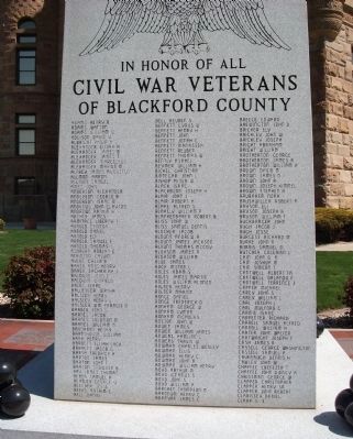
(( Front (“A - C”) - - Side ))
In Honor of All
Civil War Veterans
of Blackford County
( Row One )
Henry B. Adams • Watson Adams • William W. Adams • David V. Addison • Philip H. Albright • Elijah H. Alexander • . . . — — Map (db m54347) WM
Blackford County's second courthouse, featuring a 165 foot high clock tower, was built on foundation stones from nearby Montpelier quarries. At a cost of $129,337.83, this Richardsonian Romanesque structure was constructed 1893-1895. Listed in . . . — — Map (db m41465) HM
(( Front Center Panel ))
To honor the men and the women of
Blackford County
who fought in Korea and Vietnam
and to the heroes who gave
their lives on land,
on the sea, and in the sky
that mankind might live in freedom
we . . . — — Map (db m54423) WM
In Memory
of the
Revolutionary Heroes
who rest in Blackford County
David Kirkpatrick • John Mills
John Saxon • John Twibell • Thomas Miles
Erected by
The Nancy Knight Chapter
Daughters of the American . . . — — Map (db m54624) HM
(( Front of Base ))
“Lest We Forget”
Those from Blackford County who
answered their Country’s call in the
World War,
Apr. 6th 1917 to Nov. 11th 1918.
“Our Boys”
(( Obverse of Base ))
When the . . . — — Map (db m54272) WM
((( Center Panel )))
Dedicated to the Honor and Sacrifice of
our men and women of Blackford County
who served our Country in World War II
——— 1941 — ★ — 1945 ———
in Honor . . . — — Map (db m54607) WM
Placed on the National Register of Historic Places June 13, 1986, by the United States Department of the Interior in cooperation with the Indiana Department of Natural Resources, Division of Historic Preservation. — — Map (db m222241) HM
In 1920, a small group of women in Hartford City founded Sigma Phi Gamma, a non-scholastic sorority dedicated to friendship and philanthropy. The sorority expanded across Indiana, the U.S., and into Canada by 1929. To fulfill its mission of service, . . . — — Map (db m231195) HM
In honor of astronaut Kevin Ford, native son of Montpelier, Indiana, Blackford County, pilot of the Space Shuttle Discovery "STS 128" — — Map (db m222232) HM
F-84 F Thunder Streak
donated to City of Montpelier
by
U. S. Air Force and the 122nd
Tactical Fighter Wing, Indiana
Air National Guard
September 12, 1970 — — Map (db m222236) WM
Forever honoring the pioneers of Montpelier and the community who built the foundation for the freedom we cherish today.
1836 - 1976 — — Map (db m222231) HM
Reserved by U.S. to Chief Francois Godfroy of the Miami Nation of Indians by treaty at St. Mary's, Ohio, 6 October 1818, 3,840 acres on Salamonie River at La Petite Prairie, Harrison Township, Blackford County; reserve lands sold 1827, 1836. — — Map (db m63825) HM
This plaque is erected in honor of the Montpelier alumni who taught in Montpelier schools
Adrian Burris Geary 1898 • Bessie Slater 1899 • Mary Dailey Black 1900 • Grace A Maddox 1903 • Charles B. Anthony 1907 • Grace Kitterman Smith 1908 • . . . — — Map (db m238632) HM
Prominent educator and statesman Herman B. Wells was born in Jamestown, Indiana. During the Great Depression, he directed research for the Indiana Bank Commission, producing state banking reforms. In 1938, Wells was elected President of Indiana . . . — — Map (db m175678) HM
Jamestown War Memorial
Dedicated to the
memory of all
Veterans of all Wars
Great is he who
lays down his life for
his Country in the name
of Freedom.
Erected by the people
in the year of Our Lord . . . — — Map (db m43762) WM
Boone County Bridge 41, over Sugar Creek was a triple stone
arch built in 1901 by Theodore Eck and Charles Ridout
of Lebanon, IN. The cost was $4000.00. B.F. Baker, county
surveyor, served as engineer and construction supervisor.
In 1905 the . . . — — Map (db m289084) HM
Enroute to Washington, D.C., to become 16th President of the U.S., addressed citizens of Lebanon and Boone County from rear of railroad passenger car at this place on the evening of February 11, 1861. — — Map (db m3811) HM
( Center - Engraved in Stone: )
In Memory of our
Boone County Veterans
who Bravely Served
in Our Wars.
Erected by The American Legion
Brown - Dolson Post 113
Lebanon, Ind.
( Left Bronze Plaque: ) . . . — — Map (db m21359) WM
This property has been
placed on the
National Register
of
Historic Places
2011
by the United States
Department of Interior
thanks in part to
Bud Falke — — Map (db m251052) HM
Brothers Mel and Don Kenyon impacted American open wheel racing in a way which, perhaps, will never be duplicated. Mel began his career in 1954, driving stock cars. When Don left the Air Force, in 1958, they bought a midget with his mustering out . . . — — Map (db m265556) HM
In Memory
of Revolutionary Soldiers
Buried in
Boone County Indiana
Arthur Andrews 1753 - - 1834
John Ferguson 1759 - - 1839
William Gipson 1753 - - 1835
James Hill 1745 - - 1854
Henry Johns 1757 - - 1833
John Leap 1735 - - . . . — — Map (db m241648) WM
A progressive politician and lifelong Democrat, Ralston met the challenges posed by Indiana’s transition to a more urban and industrial state. Born 1857 in Ohio, he opened a law office in 1886 in Lebanon, where he lived until elected governor in . . . — — Map (db m175673) HM
Henry C. Ulen, an international
contractor from Boone County,
founded multiple construction
companies in the early 1900s. His
companies' infrastructure projects.
including the Marathon Dam in Greece,
parts of the Trans-Iranian and . . . — — Map (db m250683) HM
The Boone County REMC built Indiana's first electric cooperative line to the Clark Woody farm 5 miles west of this site with funds borrowed from the Rural Electrification Administration, July 22, 1935. — — Map (db m27673) HM
Ka-wi-a-ki-un-gi Village "Place of Thorns" (Thorntown) was center of 64,000 acre Thorntown Indian Reserve. Granted to Eel River Miamis in 1818, ceded to U.S. in 1828. — — Map (db m21352) HM
Black southerners established a thriving, free community around Thorntown in Sugar Creek Township by the early 1850s. Most became farmers and some owned property, despite Indiana's constitutional prohibition of black settlement. By 1870, this . . . — — Map (db m174247) HM
Albert S. White, for whom Whitestown is named, was president of the Indianapolis & Lafayette Railroad. White was a United States senator and Representative from Indiana and a leading abolitionist. He was appointed to a select federal commission by . . . — — Map (db m175788) HM
Commemorating the historic Lafayette & Indianapolis Railroad. On May 1st, 1865, at 1:07a.m., the Lincoln Funeral Train passed through Whitestown with mourners lining the tracks in the middle of the night to pay homage to the assassinated 16th U.S. . . . — — Map (db m175790) HM
Abraham Lincoln enroute to Washington as President Elect on February ll, 1861 addressed the Citizens of Zionsville at the Railroad Depot which stood on this site. — — Map (db m8326) HM
Located in Eagle Township in Boone County, Indiana, this
intact family farmstead includes a farmhouse and related
outbuildings, and was named a Historic District on the
National Register of Historic Places by the National Park
Service in 2011.
. . . — — Map (db m231487) HM
With proceeds from the sale of 170,580 acres of Indian land granted by the Federal Government, Indiana built its first north-south road. Surveyed 1829, passable by 1834, "completed" in 1837, its cost was $242,000.00. — — Map (db m67191) HM
Site of
First Post Office, Lot No. 4, 1853
Postmaster: John W. Vaughn
First Dry Goods Store and Grocery Store, Lot No. 4, 1852
Wiley & Vaughn
First House erected
John Miller’s hous, Lot No. 1, 1852
and Boarding House
Zion . . . — — Map (db m175807) HM
Patrick H. Sullivan, 1794-1879, was the first white settler in Boone County, 1823, and built the first log cabin. In 1857, he bought this site and lived here until 1872. He served in the War of 1812. — — Map (db m67190) HM
On these grounds stood one of Zionsville’s first and finest hostelries. It was a two story frame structure, erected in Civil War days, and razed in 1938. It served as a rooming house, meeting place, and occasionally as the village social . . . — — Map (db m175824) HM
In the beautiful Eagle Creek valley of southeastern Boone County, a new town was planned on land owned by Elijah and Mary "Polly" Cross.
Convinced by Lebanon businessman William Zion, a director of the Lafayette & Indianapolis Railroad, the . . . — — Map (db m8328) HM
These Civil War Cannons
were rededicated after
restoration by the
American Legion Post #2
Brazil, Indiana
on May 30th, 1998 by
Commander Thomas W. Owen — — Map (db m18910) WM
County formed by Indiana General Assembly 1825; named for national statesman Henry Clay. First county seat at Bowling Green; had three courthouses: first built 1827 was two-story log structure; second and third built 1839-1840 and 1852-1853 were . . . — — Map (db m18883) HM
Pioneering lawyer and entrepreneur Elizabeth 'Bessie' Eaglesfield was born in Clay County in 1853. Indiana's constitution denied women suffrage while also requiring attorneys to be voters. Nevertheless, she gained admittance to the bar in 1875 . . . — — Map (db m309028) HM
Jimmy Hoffa was born in Brazil, Indiana in 1913. His family struggled with poverty, inspiring him to become an organized labor leader during the Great Depression. He became active in the International Brotherhood of Teamsters in the 1930s and served . . . — — Map (db m238479) HM
(On Stone Bench)
To Keep forever living the freedom for which they served
we dedicate this symbol to those men and women who served in Vietnam.
(Left - Bronze Plaque)
Dedicated to the memory of these men who gave . . . — — Map (db m18912) WM
Brazil, just like her sister US 40 communities, prospered due to its location on the National Road. With the 1926 designation of the National Road as US 40, Brazil instantly became linked with the rest of the nation. Almost every raw material, . . . — — Map (db m233271) HM
The symbol of our company since 1931, the Great Dane Dog is the most elegant and distinguished of the giant type dog. A true great dane breed is spirited and courageous, yet always friendly and dependable. These special attributes coupled with . . . — — Map (db m259934) HM
Honoring a century of conservation and outdoor recreation. Celebrating unique, cherished places where future generations can experience nature and history.
Shakamak established 1929.
Governor Michael R. Pence
Lt. Governor Eric J. . . . — — Map (db m285580) HM
Dedicated to the distinguished Air Force Generals from Clinton County
Brigadier Generals •
James W. Lucas •
James P. Ulm
Lieutenant Generals
Jay W. Kelley •
James F. Record — — Map (db m232384) WM
( Center Panel )
Clinton County
War Memorial
All Gave Some.
Some Gave All.
Dedicated to All
Clinton County
Veterans
( Left - Large Panel )
Civil War * 1861 - - 1865
( Row One )
Wm. H. Abbott • Alfred R. . . . — — Map (db m21436) WM
Hall of Famer Everett Case, known for his basketball strategies and promotion of the sport, began his high school coaching career at age 19. After stints at Columbus and Smithville, he coached Frankfort for 17 seasons starting in 1922. He led his . . . — — Map (db m238480) HM
Old Stoney was built in 1892 and served as the Frankfort High School. On February 24, 1922 there was a fire that completely gutted the building, leaving only the four walls. Using the original walls, the building was rebuilt and reopened on . . . — — Map (db m278908) HM
( Top has Insignia of the "Navy Club U.S.A." )
This memorial is erected to
revere, honor, and perpetuate
the memory of our departed Shipmates
Roy E. Boggess
Ship No. 11 — — Map (db m21430) WM
(Upper - Bronze Plaque:)
This Tablet Is Dedicated
To The Memory Of
The Revolution Soldiers
Buried in
Clinton County
Captain Harmon Aughe •
John Applegate •
William Carter •
Thomas Harris •
John Reed •
Frederick . . . — — Map (db m21438) WM
Diplomat James G. McDonald grew up in Albany and taught history at Indiana University by 1910. Representing the Foreign Policy Association, he met with Nazi officials in 1933, including Adolph Hitler who was quickly rising to power. McDonald . . . — — Map (db m203649) HM
The first significant commercial gas well came in Sept. 15, 1886, near here south of the Mississinewa River and East of the railroad, ushering in the gas boom era. Almeron H. Crannell, a Civil War veteran and later resident of Hartford City, drilled . . . — — Map (db m63797) HM
Once promoted by its boosters as an ideal location for the Delaware County seat, this community was officially platted in 1836 by John Gregory, David Shideler and Peter Thomas. It is the successor to Georgeville, platted a short distance up the . . . — — Map (db m141446) HM
Dedicated to those who lost their lives in the service of our country and forever honoring the men and women of this community who served in the Armed Forces — — Map (db m141433) WM
On June 12, 2021, this location was dedicated to Don
Talley, Citizen Driver. Don is a decorated veteran who
served in the U.S. Army from 1974 to 1994 and began his
trucking career while serving in Saudi Arabia.
Don is a natural born leader, . . . — — Map (db m180759) HM
Joseph Wilson and Uriah Powers first operated a flour mill and a sawmill around which the village of Elizabethtown grew up in the 1830s. Wilson named the town after his daughter, Elizabeth, and had high hopes for the community as a prospective . . . — — Map (db m141424) HM
Site of production mill and three beehive kilns, first fueled by wood and then by natural gas, circa 1883-1910, owned & operated by Manassa Myers, Sr. family. Produced drainage tiles (hollow cylinder-shaped sections) from adjacent clay pit for local . . . — — Map (db m63796) HM
The Barlett, Bryant, Vannata, and Veach families were the first settlers in 1837-1839.
In 1840-1850 the McCreery, Woodring and Maynard, Rowlett and Thompson families became property owners.
Snagtown ~ New Corner was platted by David L. . . . — — Map (db m141475) HM
This building was originally called
Richwoods Church for the dense growth
of black walnut and other valuable
timber in the area. The founding
pastor was Rev. Samuel Sayford, who
with his wife Mary, moved from Virginia
and ministered on . . . — — Map (db m231348) HM
The first school house in Delaware County was erected in a trackless forest one half mile west of this site. “Indian Jim,” the last of the Delaware tribe remaining in this county, a highly respected resident
hewed the black walnut logs . . . — — Map (db m141163) HM
This imposing home was built by businessman, George Riley Jones and his wife, Margaret, in 1901-1903. Alfred Grindle, the architect, designed this Colonial Revival style building. The Jones' enjoyed and occupied this house during their lifetime.
. . . — — Map (db m231344) HM
Company incorporated in New York 1886 to manufacture glassware (particularly fruit jars). Brothers Edmund, Frank, George, William, and Lucius Ball all were trustees. Company - promised money, land, and free natural gas - came to Muncie; first . . . — — Map (db m31345) HM
To meet Muncie’s higher education needs, the Ball Brothers gave land, money, and the building here to the state in 1918. Their gift became the Indiana State Normal School Eastern Division and was renamed Ball Teachers College in their honor in 1922. . . . — — Map (db m231197) HM
Dedicated to all Delaware County
Veterans for all wars
A patriotic sacrifice forever
The memories will live forever
We will remember them
— — Map (db m141705) WM
Side A
Founded as Gray & Hemingray in
Cincinnati, Ohio in 1848. Incorporated
1870 in Covington, Kentucky; company
produced glass bottles, jars, oil
lamps, light globes, tableware and
insulators. After discovery of natural
gas in . . . — — Map (db m65208) HM
In remembrance
of the Delaware County Civil War Veterans / POWS of the 9th Cavalry, 121st Regiment — especially to those who lost their lives when the steamboat Sultana exploded, April 27, 1865 on the Mississippi River, 7 miles north of . . . — — Map (db m141230) HM
“Four score and seven years ago our fathers brought forth on this continent a new nation, conceived in liberty, and dedicated to the proposition that all men are created equal. Now we are engaged in a great civil war, testing whether that . . . — — Map (db m141265) HM WM
Several principal Indian and Pioneer Paths cut across Indiana and Delaware County
connecting trading and warrior routes of ancient times. First made by migrating large animals searching for salt, followed by Native Americans for food, trade and . . . — — Map (db m141410) HM
Structure, circa 1893, is Muncie's oldest standing public school building. Purchased by church congregation, circa 1928. Rallying point in August 1930 when bodies of two African-American men, lynched in Marion, were brought to Muncie for embalmment . . . — — Map (db m31346) HM
This boulder marks the traditional
site of Wah-Pe-Kah-Me-Kunk
the White River Town of the Muncee Clan of Delaware Indians.
It is, also, a memorial to Joshua, a Christian Indian, who was burned by the tribe, March 1806, a martyr to his . . . — — Map (db m141131) HM
Dedicated to the Veterans of W.W.I ★ W.W. II ★ Korea and Viet Nam who served
their country with honor and all who gave their lives for freedom — — Map (db m141233) WM
The two blocks of granite placed here were salvaged from the W.A. McNaughton Building, which was demolished in 1989. They were design elements of the main entrance on Walnut Street. The building was constructed in 1901 at the south east corner of . . . — — Map (db m141269) HM
The ground floor was modified several times to accommodate new tenants including Schuster Brothers, Men's Town, York Furs, and Murray's Jewelers. — — Map (db m222316) HM
This building was purchased by William F. Freund and renamed the Freund Building. At this time the McNaughton Building (Ball Stores) and the Johnson Building also stood at the corners of Walnut and Charles Streets. — — Map (db m222315) HM
This building was purchased by Steven and Todd Murray, the fourth generation of Murray Jewelers. At this time only the McNaughton Building (Ball Stores) and this building remained at the intersection of Walnut and Charles Streets. — — Map (db m222317) HM
This building was listed in the National Register of Historic Places as a contributing structure to the Walnut Street Historic District in 1989. It was designated as a local landmark by Muncie City Council in 1990. — — Map (db m222318) HM
Steven and Todd Murray, Community Development, and the Urban Enterprise Association renovated the exterior of this building back to its original design character and renamed it the Murray Building. — — Map (db m222319) HM
Downtown Muncie offers vibrant cultural experiences for all ages. Within a 30 block area major cultural venues anchor a lively district of galleries, performance spaces, restaurants, pubs and taverns featuring live entertainment.
Family . . . — — Map (db m222310) HM
This property
Boyce Block
has been placed on the
National Register
of Historic Places
by the United States
Department of the Interior — — Map (db m222323) HM
Goldsmith C. Gilbert, New York trader and miller who came to Delaware County in the early 1820s and operated a trading post on the Mississinewa River, acquired the Hackley Reserve and erected a cabin on this square in which his daughter, Mary Jane, . . . — — Map (db m222292) HM
1645 entries matched your criteria. The first 100 are listed above. Next 100 ⊳