English:
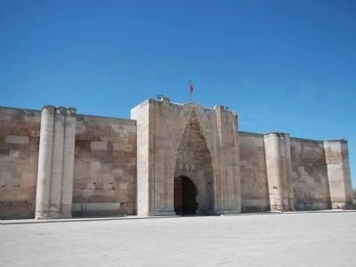
Situated on Konya - Aksaray highway, Sultanhanı is the largest and best caravanserai of the seljuks. It was built by Alaattin Keykubat 1. in 1229. After a fire, it was restored and extended in 1278 by the governor Siracettin . . . — — Map (db m84169) HM
English:
Its construction date is not known clearly. It it thought to be constructed by Hittites who placed a manial area in the city. But this thought has not been verified with archeological findings. Before Hittites, Ankara Castle had . . . — — Map (db m83912) HM
English:
History
The Çengel Han was built in 1522-1523 during the reign of Kanuni Sultan Süleyman by Damat Rüstem Paşa who was married to the Sultan’s daughter Mihrimah Sultan. Though it was built close to 500 years ago, the . . . — — Map (db m83891) HM
English:
The museum consists of two buildings, the Bedesten and the Kurşsunlu Han. The Bedesten (covered market), not arranged as the exhibition hall, was built by Mahmut Pasha, Grand Vizier (1455-1466, 1472-1473) under Mehmet II, the . . . — — Map (db m83995) HM
English:
İsmet İnönü was the first prime minister and the second president of the Turkish Republic. He was born in Izmir in 1884. He received his primary education and graduated from military high school and Academy of Artillery . . . — — Map (db m83979) HM
English: The building complex that measures 75 x 75 m includes a central area limited by porticoes and shops. The macellum has an entrance on all four sides. The shops on the north and west face alternately the macellum or the street . . . — — Map (db m84207) HM
English: The earliest archaeological finds at Perge, a very important city in the region of Pamphylia, date from the end of the fifth millennium B.C. and come from the acropolis. These are followed by uninterrupted layers of habitation . . . — — Map (db m84210) HM
The first dig at Perge had been made by Ord.Prof.Dr.Arlf Müfit Mansel and his team under his leadership in the year of 1946. Between the years of 1975-1986, the digs were made under the leadership of Prof.Dr.Jale Inan. During the digs the remains of . . . — — Map (db m84215) HM
English: There are four doors opening into four directions on the walls of the ancient city of Perge. However, in the south, there are two doors which were made at Hellenistic and Roman periods and there is a courtyard of 72.2m between two . . . — — Map (db m84209) HM
English: The complex, one of the best preserved buildings in Perge, is noteworthy because of its size and monumentality when compared with its counterparts in Pamphylia. Rooms that served different functions like the dressing room . . . — — Map (db m84208) HM
English: In antiquity, central part of Antalya was known as “Pamphylia”, the land of all tribes, and is thought to have been settled originally by migrating people from Anatolia. Pamphylia grew into a populous region and many fine cities . . . — — Map (db m84193) HM
Theatre of Aspendos is the best preserved ancient theatre in Asia Minor and the most Magnificent Roman building of the province of Pamphylia as well. It was designed by the architect Zeno, son of Theodorus. This theatre by Zeno shows the final . . . — — Map (db m84194) HM
English Text:
View of the outside of the Troia II/III Citadel Wall, ca 2500-2200 BCE.
(Schliemann's 'Burnt City').
This reconstruction built with hand made and fired mudbrick preserves the original mudbrick material, which is . . . — — Map (db m123278) HM
English Text:
You are now standing on the remains of the outer wall of the Greek and Roman temple precinct from the period of Troia VIII/IX (third century BCE - c. CE 500). In front of you lie the fortifications of Troia/Ilios. You . . . — — Map (db m123200) HM
English Text:
You are now standing on the remains of the foundations of an altar which belonged to the Greek and Roman temple of Athena (see Information-Sign 4). The remains of this temple had already been removed by stone-robbers . . . — — Map (db m123228) HM
English Text:
These large vat-like storage containers appear in the Mediterranean and Near East already in the Neolithic period along with the earliest pottery. They served primarily as a means to keep cool olive oil, wine, and grain, . . . — — Map (db m123122) HM
English Text:
Where you are now standing there once lay the forecourt of the temple of Athena belonging to the Greek and Roman city Ilion. Looking down you can see in the center of the mound a wide area at a lower level. This was . . . — — Map (db m123252) HM
The church with an octagon core was built at the beginning of the 5th century on the summit of the hill. This is probably where, according to tradition, the Apostle was martyred. The building has an eight-sided central room surmounted by a wooden . . . — — Map (db m118853) HM
Built to a U-shaped plan with two wings enclosing the large basin. The lower part is built of more regularly-shaped travertine blocks, while the upper part has blocks of varying dimensions, clearly taken from previous structures. On the basis of the . . . — — Map (db m118898) HM
In the latest years the theatre continues to represent one of the top priorities for the Italian Mission, that continues the studies and has started important actions of preservation, restoration and presentation of the monument.
The project of . . . — — Map (db m118880) HM
English:
Following the passing of Mevlâna on December 17th, 1273, Alâmeddin Kayer and Gürcü Hatun the wife of Süleyman Pervade the Seljuk Emir made Bedridden from Tebriz build a tomb one year later.
Three sections of the tomb that rise . . . — — Map (db m84274) HM
English:
Date: 13th Century
Built by: Unknown
Architect: Unknown
Ahmed Eflâkî Dede narrated detailed and important information about Hz. Mevlâna and Mevleviyeh with his book called “Menâkibü’l-Ârifîn” (Anecdotes . . . — — Map (db m84275) HM
English Text:
The remains of the ancient city of Thyateira, which is located within the borders of the county town of Akhisar, have been uncovered mostly in two areas named as the "Tepe Mezarligi" (Hill Cemetery) and the "Hastane . . . — — Map (db m119733) HM
English Text:
The striking remains of the ancient city of Thyateira are located in the "Tepe Mezarligi (Hill Cemetery)" in the county town of Akhisar. The archeological excavations in this region were carried out by Professor Dr. Yusuf . . . — — Map (db m119765) HM
English Text:
In the excavations carried out in the east of the area called the "Tepe Mezarligi" (Hill Cemetery) within the range of the ancient city of Thyateira, a typical Roman street with columns was unearthed which lies in the . . . — — Map (db m119801) HM
English Text
The Yildirim Beyazit Mosque, reflecting Ottoman architecture, located in Alasehir district of Manisa province.
Construction of the mosque was started between the years 1390-1400 by the Ottoman sultan Yildirim . . . — — Map (db m119167) HM
English Text:
Bathing was a part of an important Roman social tradition, which spread throughout the Roman Empire. That tradition emphasized the benefits of leisure and combined the pleasure of bathing in tepid, warm, and cold water . . . — — Map (db m119407) HM
Turkish Text:
Iki odali W/8-9 no''lu dükkân, muhtemelen boya üretim ve satis
yeri olarak kullanilmistir. Her iki odaya da dogruca revaktan
ulasilabiliyordu. Daha küçük olan W9 no''lu odanin tabani tuglalarla
kapliydi ve olasilikla . . . — — Map (db m119303) HM
The crane was brought to Sardis in 1911 by the Howard Crosby Butler Expedition and was used for lifting and moving fallen architectural blocks during excavation of the temple of Artemis, 1910-1914. The crane was operated by hand, had a lifting . . . — — Map (db m119416) HM
Turkish Text:
Hamamin güney girisinin her iki yaninda yer alan dükkânlar büyük
bir olasilikla lokanta veya taverna olarak hizmet vermekteydi. W1-2
no''lu dükkânin kazisinda iki adet ocak yeri ve yiyecek kaplari elde
edilmistir. W2 . . . — — Map (db m119305) HM
Turkish Text:
E5 no''lu dükkânin küçük olmasi ve içinde ilginç ev objelerinin bulunmasi, buranin bir mesken
olarak kullanildigina isaret etmektedir. Fevkalade enteresan objeler arasinda, uzun adimlarla
yürüyen aslan seklinde, . . . — — Map (db m119351) HM
English Text:
This monumental Roman avenue was one of a series of important east-wes
thoroughfares that passed through Sardis over a span of 2500 years. During the Lydian period (7th and 6th centuries BC), a road near here approached . . . — — Map (db m119309) HM
English Text:
Sardis (Sardeis in Greek, Sfard- in Lydian, Sparda in Persian, Sart in Turkish) has been the name of the settlement here for more than 3,000 years. The earliest known occupation dates from the Late Bronze Age, c. 1400 BC, . . . — — Map (db m119223) HM
This monumental synagogue occupied the southeast corner of the Roman bath-gymnasium and served as the center of a prosperous Jewish community during late antiquity. Discovered in 1962, the building is the largest known synagogue of the . . . — — Map (db m119383) HM
English Text:
Apse and Benches
The curved wall of the apse was once pierced by three niches and two vaulted passageways. The openings were later blocked and the wall covered with bands of white and colored marble. Three tiers of . . . — — Map (db m119405) HM
English Text:
Fountain
The large krater or vase at the center of the forecourt is a replica of the marble original, a fountain where congregants washed before prayer. Water was supplied by terracotta pipes below the floor. An . . . — — Map (db m119363) HM
English Text;
The temple, one of the largest in the world, was originally dedicated to Artemis. It faced west like other Anatolian temples of Artemis such as those at Ephesus and Magnesia. The two complete columns have stood intact . . . — — Map (db m119488) HM
English Text:
The Altar of Artemis (or "Lydian Altar") is the oldest preserved
building in the sanctuary of Artemis, and was the focus of its ritual and ceremony. It has two main building phases, one of
which is older than the temple. . . . — — Map (db m119504) HM