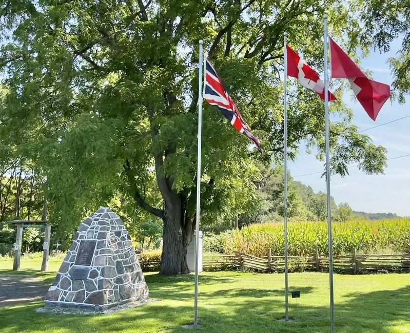
To commemorate
opening Huron Road
by the Canada Company
1828
This marks place of
log building occupied by
Sebastian & Mary
Fryfogel
first settlers in
Perth County 1829 — — Map (db m233404) HM
A World War I flying 'ace’; McKeever was born and raised
in Elma Township. He enlisted with the Canadian Expeditionary Force in 1916 but, attracted by the life of the fighter pilot, transferred to Britain's Royal Flying Corps once he was . . . — — Map (db m277958) HM
This Clock Tower is a replica of the original Post Office
Tower once located on the north-west corner of Main St. and
Argyle Ave. N.
The Post Office was built in 1911 and demolished in 1982.
The original clock works and dials were . . . — — Map (db m277975) HM
Among the earliest settlers on the site of Listowel was John Binning who, tradition has it, became the community's first permanent settler in 1852. Within four years D. D. Hay, one of the most enterprising early settlers, had erected a sawmill and a . . . — — Map (db m277986) HM
By 1851 Andrew West, a New York native, had opened a hotel in the recently surveyed township of Mornington. This building was the focal point around which a small community initially known as West's Corners developed. The hamlet grew gradually and a . . . — — Map (db m277950) HM
An outstanding hockey player, Howard William Morenz was born
in Mitchell. He began his career with the Mitchell Juveniles, 1916-17, and after his family moved to Stratford, he played with several teams there. His skilful play, characterized by . . . — — Map (db m282495) HM
Erected
1928
In memory of Andrew & Eva Seebach
The first settlers
in Ellice Township
December 1828
Restored in 2001
by Ellice History Book Committee — — Map (db m282488) HM
Erected about 1844-5, this building was situated on the Huron Road, a pioneer highway which opened up the Canada Company's Huron Tract. Its original owner,
Sebastian Fryfogel, said to be the first settler in Perth County, was operating a . . . — — Map (db m233351) HM
This building was constructed
for William Andrews a local
jeweller in 1884. Designed in
the Second Empire style by local
architect William Williams, it
was constructed by stonemason
John Grant and carpenter
Alexander Falconer. Its . . . — — Map (db m303921) HM
The Right Honourable Arthur Meighen, P.C., M.P.
(B. Anderson, Ont. June 15, 1873- d. Toronto, Ont. August 5, 1960)
Member of Parliament for the constituency of
Portage la Prairie (1908-21, 1921-25); leader of
the . . . — — Map (db m304056) HM
The Grand Trunk was incorporated in 1853 to run from
Sarnia to Portland, Maine, Although it took in existing
lines, new ones had to be built, including the Toronto to
Sarnia section which was undertaken by the Canadian firm
of Gzowski and . . . — — Map (db m193016) HM
In 1857, the Grand Trunk Railway announced plans to extend its main line from Toronto to Sarnia. As it passed through St. Marys, it was necessary to build two high trestle bridges, one across the Thames River, the other across Trout Creek to . . . — — Map (db m198280) HM
No one had a greater impact on the Town of St. Marys in the 20th century than John Grieve Lind. Most closely associated locally with the St. Marys Cement Company, he was the main spokesman during negotiations with the town prior to the start-up of . . . — — Map (db m304023) HM
This fine limestone block was built by local retailer John McDonald sometime
previous to 1859. It boasts one of the earliest and best preserved store
fronts in the town.
In addition it is on or near the site of one of the first log stores . . . — — Map (db m303919) HM
The Mill Race exists as a reminder of the importance of the mills to the settlement of St. Marys in the 1800's. Thomas Ingersoll's original mill by Trout Creek was built in 1841 and by 1864, when the Victoria Bridge was built, other permanent mills . . . — — Map (db m303908) HM
Thomas Ingersoll established a grist mill on this site in 1843 and milling continued here until the mid-1970's. This mill wheel, manufactured by Barber Sons, Meaford, was installed c. 1910. Replacing earlier water wheels, it provided water power . . . — — Map (db m303812) HM
Timothy Eaton's older brother,
Robert, purchased this Queen
Street property in 1857.
By 1872, he had built this brick
building where he operated a
grocery and dry goods business
until 1890. It is one of the oldest
commercial brick . . . — — Map (db m303925) HM
Background:
When the St. Marys Cement Plant officially opened in November 1912, a process to manufacture Portland cement using quarried limestone mixed proportionately with clay had recently been
developed. St. Marys had been well known for . . . — — Map (db m303749) HM
This station was constructed in the summer of 1907 for the Grand Trunk Railway. It was the third depot on the line at St. Marys, following the Junction Station erected in 1858 and the station at “The Switch” erected in 1879. The general contractor . . . — — Map (db m198301) HM
The St. Marys Opera House was constructed in 1879-80 for the St. Marys Lodge of the Independent Order of Oddfellows. It was designed by Silas Weekes, a local architect and member of the lodge. James Elliott, the master mason, supplied stone from his . . . — — Map (db m303808) HM
In 1904 Andrew Carnegie donated $10,000 for this limestone library. Town Council agreed to provide a site and to maintain library at $1,000 a year.
J.A. Humphris was the architect, and Robert Clyde, local stonemason, was the builder.
The . . . — — Map (db m198286) HM
In April of 1899 a delegation of concerned citizens approached St. Marys Town Council to request a plebiscite for the purpose of installing a municipal water system. Council granted their request and prepared the necessary by-law. Three months later . . . — — Map (db m198287) HM
This commercial limestone block was
built in the 1850's as a general store.
It is believed to be the fist permanent
location of a banking institution in St.
Marys, having housed the Bank or Montreal from 1862 - 1889. — — Map (db m303805) HM
This limestone block was constructed, probably by Robert Barbour, as a store, with residence above, for Theodore Hufton in 1868. Its facade is a fine
example or the Italianate style.
It was restored by the St. Marys Lions Club in 1987. — — Map (db m303806) HM
Designed by Mr. W. Williams, this bridge was built by local stonemasons Messers James Clyde and James Elliot and completed on October 13, 1884, at a cost of $3,800.
Restored in 1979 by the Town of St. Marys with a grant from The Ontario Heritage . . . — — Map (db m198283) HM
Millennium Park
This park area was dedicated in 2000 to the memory of early settlers whose hard work and enterprising spirit spurred the growth of this community and paved the way for future generations.
In the late 19th and early 20th . . . — — Map (db m304096) HM
In 1841 John Ingersoll built a
log general store on this site. Around
1854, W. V. Hutton an early mayor
of the town had the first two stories
of the present building built by L.
Cruffenden. C1884 the third storey
(Mansard) was completed, . . . — — Map (db m303911) HM
The quarry has been part of St. Marys life for decades. Many local people learned to swim here and are happy to share its cool, refreshing waters with out-of-town visitors every summer. But the use of the site today as a recreation area would have . . . — — Map (db m303756) HM
This limestone building was constructed as the home of early pioneer George Tracy, c. 1854, near the site of his earlier log cabin. The house, which was the first substantial dwelling in the district, was designed and built by Roberts Barbour; . . . — — Map (db m303740) HM
In 1891, after the frame town hall on this site burned, Town Council ran a competition for the design of the new town hall. Toronto architect G.W. Gouinlock's plans for a Richardson Romanesque building were chosen.
The structure, of St. Marys . . . — — Map (db m198284) HM
History of the Water Street Bridge
Because of its location at the confluence of the Thames River and Trout Creek, St. Marys has always been dependent on its bridges. The spectacular railway viaducts across the two river valleys enabled the . . . — — Map (db m304103) HM
Built in 1906 and 1908, these two Edwardian commercial buildings are intact and retain their architectural continuity.
A Property Designated Under the Ontario Heritage Act 1974 — — Map (db m301428) HM
Originally an L-shaped building, this early Edwardian structure
with late Victorian features was built in 1903 for the Mooney Biscuit and Candy Company.
A Property Designated Under the Ontario Heritage Act 1974 — — Map (db m301427) HM
Part of business blocks largely erected by John Lynch, an early
resident. Extended over the years, to include a tower complementing
nearby buildings.
A property designated under the Ontario Heritage Act 1974 — — Map (db m301762) HM
Opened 1899
Designers
G.W. King J.W. Siddall
Contractors Cawsey & Youngs
A floorplan of
geometric shapes
replaced earlier city
hall burnt in 1897
Refurbished 1973-74
A property designated under the
Ontario . . . — — Map (db m198310) HM
Row of four houses later converted for business uses including the Stratford
Shakespearean Festival 1953-58. Built by Thomas Mayne Daly, Mayor 1869-70, 76-78. — — Map (db m301579) HM
Constructed on a fieldstone
foundation, this building is made of solid buff
brick. The arched windows have decorated headers containing
cast keystones.
A Property Designated Under the Ontario Heritage Act 1974 — — Map (db m301580) HM
In 1978, architecturally significant business blocks
in this area were combined
into one complex preserving their landmark quality in the community.
A property designated under the Ontario Heritage Act, 1974 — — Map (db m301856) HM
Since the mid 1840's, early settlers of Stratford were being buried in the land surrounding St James' Anglican Church. It has become known as "God's Holy Acre". Today we continue that tradition as we bury the ashes of loved ones in the Memorial . . . — — Map (db m301694) HM
The last significant structure created during
the 30 years of building and rebuilding the
downtown “in brick” 1870-1900. Erected by
William Gordon, mayor,
1884-85, 1907-08. — — Map (db m301859) HM
Home Children
Between 1869 and 1939, about 100,000 child immigrants, casualties of unemployment and poverty in Britain, were uprooted from their homes and families. With hopes of giving them new lives in Canada, British agencies . . . — — Map (db m279490) HM
Designed by Alexander Hepburn and built by Alexander Corrie, this stone bridge remains one of the few surviving examples in Ontario
A property designated under the Ontario Heritage Act 1974 — — Map (db m301944) HM
Knox Presbyterian Church
is an excellent example
of a later Collegiate
Gothic Revival style
building and has
prominence to the
city's streetscape. — — Map (db m280330) HM
One of the first brick buildings south of City Hall put up
during the erection of the prosperous Grand Trunk repair shops
nearby. Built by Charles Browning. — — Map (db m301441) HM
Erected in common by
Susannah M. Byrne, Joseph
Kneite and Gilbert Horne
on adjoining properties
once owned by John Lynch, a pioneer popular brickwork design of the day.
Stratford Architectural Conservation Advisory Committee — — Map (db m301855) HM
A life-long member of the Stratford Parks Board, R. Thomas
Orr was the driving force behind the Stratford parks system.
Orr led the fight to save the riverfront and millpond from
railway development and oversaw the transformation of . . . — — Map (db m284041) HM
An outstanding Canadian scientist, McLennan was born in Ingersoll and moved to this house in 1883. He attended the University of Toronto where he later became Head of the Physics Department. His research and publications brought international . . . — — Map (db m279328) HM
This church, third on
the site, was designed
by Gundy and Langley in
decorated Gothic style
and opened by Benjamin
Cronyn, Bishop of Huron
20 March 1870.
A Property Designation under the Ontario Heritage Act 1974 — — Map (db m301695) HM
[English] Stratford's spacious civic square has been the site of the city's municipal buildings since 1857. Construction began on the present city hall after the destruction of the first town hall and market by fire in 1898. The plans were . . . — — Map (db m198303) HM
"With one bold stroke that has left our big cities gasping, Stratford, Ont. will this summer claim its birthright with a Shakespearean festival!" This was how Maclean's magazine saw the beginning of the Stratford Festival in 1953. It was bold . . . — — Map (db m301710) HM
Stratford Normal School
In the 1900s, concerns about the quality of rural education
prompted the Ontario government to build four new
Normal Schools to increase the supply of qualified teachers
in the province. Identical . . . — — Map (db m279286) HM
In the first half of the twentieth century, Stratford was home to Canada's largest furniture industry. It employed about a quarter of the city's workforce, the second largest industry after the railway which employed about a half. During the 1920s . . . — — Map (db m279482) HM
Stratford and the Railway
The most important factor in the early development of the town of Stratford was the arrival of two different railways in 1856. The railway crossroads created by the junction of these two competing railways, led to . . . — — Map (db m301296) HM
Stratford's swan parade marks the return of the swans to the Avon River from their winter quarters behind the William Allman Arena. The time of the parade, which traditionally takes place in the first Sunday of April, is determined by the urgent . . . — — Map (db m279322) HM
R. Thomas Orr suggested
the bandshell after
seeing one in the
United States. This
design was used for
the bandshell at the
C.N.E. in Toronto
and also for the
one in London. — — Map (db m279469) HM
The Dutch Memorial Garden commemorates Canada's support for Holland during the Second World War.
When Holland was occupied by Germany in 1940, the Dutch royal family escaped the occupation and came to Canada, where they lived in Ottawa for . . . — — Map (db m301693) HM
The Founding of Stratford
In 1832, some three years after company surveyors had
erected shanties near this site, the Canada Company, a
large private land settlement agency initiated the development of "Little Thames” as the . . . — — Map (db m301628) HM
W. J. Freeland came to this city in 1886 as the first supervisor of music in Stratford public schools. Over the next eight years, he conducted numerous bands and choirs that were noted both locally and provincially for their performances as well as . . . — — Map (db m301760) HM
To celebrate the Diamond Jubilee of Queen Victoria's reign on June 22, 1897, the school children of Stratford raised money to erect a fountain to the memory of W.J. Freeland, their beloved music teacher. Freeland was the first full-time music . . . — — Map (db m301759) HM
The dome atop this historical building is named in honour of Keith A. Culliton, who has served this community in exemplary fashion.
Through his terms as a School Board Trustee, Public Utilities Commissioner, City Councillor and Mayor, he has . . . — — Map (db m279303) HM
Erected in 1905, by Fred J. Corrie, this building replaced the original
wooden Queens arms Hotel circa 1850. It remains a prominent part of the
city's heritage.
A property designated under the Ontario Heritage Act 1974 — — Map (db m301947) HM
In 1904 the Canadian Pacific Railroad (C.P.R.) presented a proposal to the City of Stratford and the Parks Board to place a new track through part of the Stratford park
system in order to compete with the already established Grand Trunk Railway . . . — — Map (db m279479) HM
Opened 1936. These gardens demonstrate: Stratford's legacy of creating public spaces combining industrial heritage, with parkland.
A property designated under the Ontario Heritage Act, 2000 — — Map (db m301941) HM
The Stratford Festival
In 1953, Tom Patterson launched an
annual festival of Shakespearean theatre
in his hometown of Stratford. Artistic
Director Tyrone Guthrie and designer
Tanya Moiseiwitsch conceived the
Festival . . . — — Map (db m279305) HM
This magnificent sculpture by Walter S. Allward (1875-1955) depicts the supremacy of right over brute force and was unveiled on 6 November 1922 to honour the soldiers from Stratford and surrounding counties who fell in the First World War. It was . . . — — Map (db m301698) HM
A native of Stratford, Ontario, Tom Patterson grew up during the Great Depression and dreamed of plans that might revitalize his community. After serving in the Second World War and completing university, he worked as an associate editor . . . — — Map (db m279304) HM
The production and consumption of liquor has an interesting and unusual relationship to the history of the City of Stratford until well into the twentieth century. The mid-to late-nineteenth century, the period during which Stratford was settled . . . — — Map (db m301439) HM
Originally named the Classic City Arena this facility was officially opened December 15, 1924. It is one of the last remaining "ice palaces" of its type built in North America during the nineteen twenties and thirties and purportedly is the longest . . . — — Map (db m279321) HM
In 1836 the Canada Company, a large private land settlement agency, laid out a town plot (Mitchell) here on the Huron Road. Within a year John Hicks, one of Logan Township's earliest settlers, had erected a hotel near this point where the road . . . — — Map (db m233501) HM