On Blackbridge Road, 0.3 kilometers west of Townline Road, on the right when traveling west.
Spanning the Generations From the early days of settlement on the banks of the Grand River and its tributaries, bridges were important focal points for communities. Our significant heritage bridges have become distinctive landmarks that . . . — — Map (db m196196) HM
On Water Street South at Main Street, on the left when traveling south on Water Street South.
Former Galt Post Office
This building, begun in 1884 and
finished in 1887, was erected to house
the post office, customs, and other
government services. It was designed
under Dominion chief architect
Thomas Fuller and built by . . . — — Map (db m231734) HM
On Dickson Street at Petty Place, on the right when traveling west on Dickson Street.
This attractive public building was designed and built in 1857-8 by H.B. Sinclair, a local resident, as a "Town Hall and Market House". Galt had become an incorporated town on January 1, 1857, and the first mayor, Morris C. Lutz, was elected by the . . . — — Map (db m196195) HM
On Water Street North at Park Hill Road West, on the right when traveling south on Water Street North.
Grand River
The Grand River, flowing 290 kilometres from the Dundalk Highlands to Lake Erie, is aptly named, for its valley is the largest in Southern Ontario. A mosaic of Aboriginal
and European cultures combined to shape the . . . — — Map (db m231798) HM
On Main Street at Queen’s Square, on the right when traveling east on Main Street.
Wooden bridges 1819, 1832, 1834, 1840, 1854, 1857, 1867
Steel bridge 1878
Concrete bowstring arch bridge 1931
Restoration 2008
Spanning the Generations
Since the early days of settlement along the banks of the Grand River and . . . — — Map (db m231743) HM
On Queen’s Square at Melville Street north, on the right when traveling west on Queen’s Square.
The Honourable James Young 1835-1913
Born in Galt, Young was educated locally, and from
1853 to 1863 was editor and publisher of the Dumfries
Reformer. From 1867 to 1878 he represented South
Waterloo in the Canadian Parliament, and from . . . — — Map (db m231717) HM
On North Square (Regional Road 27) just west of Grand Avenue North, on the right when traveling west.
To honour the Women’s Royal Canadian Naval Service, and to express thanks to the City of Galt, where they received their basic training 1942-1946 Pour honorer le service féminin de la Marine Royale du Canada, et en remerciement â la ville de Galt, . . . — — Map (db m199808) HM WM
On Frederick Street at Duke Street East, on the right when traveling south on Frederick Street.
On May 24, 1929, the Cenotaph was unveiled by Honourable W,D. Ross, Lieutenant Governor of Ontario in memory of those who died in World War I. This replica of the British Empire memorial in Whitehall, London, first stood in Frederick Street and was . . . — — Map (db m196193) HM
On Frederick Street at Spetz Street, on the right when traveling south on Frederick Street.
[Top plaque]
City of Kitchener
Heritage Landmark
1939
[Bottom plaque]
A.D. 1852 – 1938
This new registry office
building was erected in
the years A.D. 1938-1939
to replace the old brick
building constructed by
the . . . — — Map (db m196192) HM
On Young Street at Duke Street West, on the right when traveling north on Young Street.
Founded in 1857, St. Mary's is the oldest Roman Catholic parish in Kitchener (previously Berlin) The early congregation was largely German and Polish. Father George Laufhuber, S.J., was the first pastor.
Father Edward Glowacki, C.R. was appointed . . . — — Map (db m244291) HM
On Queen Street North at Weber Street East, on the right when traveling north on Queen Street North.
Waterloo County
Waterloo County held its first council meeting on January 24, 1853, on this site, at the newly-built county courthouse in Berlin (now Kitchener). Council's 12 members came from five townships (North Dumfries, . . . — — Map (db m244266) HM
On Queen Street North at Ahrens Street East, on the right when traveling north on Queen Street North.
Canada's tenth prime minister was born in Berlin (Kitchener)
on December 17, 1874. A grandson of William Lyon Mackenzie,
he joined the Canadian civil service in 1900 as a specialist
in labour relations. Elected to the federal parliament . . . — — Map (db m244261) HM
On Queen Street North at Otto Street, on the right when traveling north on Queen Street North.
The terrorist attacks of September 11, 2001 claimed 2,917 lives including 343 FDNY Firefighters, 60 Police Officers and 8 Paramedics
Kitchener Connection
Kitchener Fire and the community responded to New York City's 9-11 call for help . . . — — Map (db m244206) HM
On King Street East, 0.1 kilometers Sterling Avenue North, on the left when traveling east.
Born in Lancaster County, Pennsylvania, Eby came to Upper Canada in 1806 and purchased extensive lands in this vicinity on which he settled the following year. He was ordained a minister of the Mennonite Church in 1809 and in 1812 was made a bishop. . . . — — Map (db m244322) HM
On King Street East, 0.1 kilometers east of Stirling Avenue North, on the left when traveling east.
Site of the
First Church in Waterloo County
Built of logs in 1813
by Benjamin Eby, a bishop
of the Mennonite church
Replaced by frame building, 1834
The present church was built in 1902
Tablet placed by
the Waterloo Historical . . . — — Map (db m244305) HM
Mackenzie King, grandson of William Lyon Mackenzie, was born in Berlin, now Kitchener, Ontario. As a public servant he organized the Department of Labour, and was recognized as an authority on industrial relations. Entering politics in . . . — — Map (db m244311) HM
William Lyon Mackenzie King, tenth Prime Minister of Canada, spent his adolescent years at Woodside, where he lived from 1886 to 1893. The country setting he enjoyed during this formative period among books and family mementos fostered . . . — — Map (db m244295) HM
On Huron Road, 0.1 kilometers east of Homer Watson Boulevard, on the left when traveling east.
In 1827 Dr. William “Tiger" Dunlop of the Canada Company opened the line of the Huron Road some 95 miles from Goderich to Guelph whose townsites were established that year. Improved in 1828 to promote the sale of Company lands in the million-acre . . . — — Map (db m244373) HM
On Huron Road, 0.1 kilometers east of Homer Watson Boulevard, on the left when traveling east.
In 1912, the Waterloo Historical Society was formed to preserve the unique heritage of Waterloo County. Meeting in the Berlin (later Kitchener) Public Library, WHS began collecting and preserving local artifacts, photographs and documents under the . . . — — Map (db m244375) HM
Erected by the German-Canadian
Business and Professional Association
to mark the
Centennial of Victoria Park
1896-1996
and to remember the founders of this city who,
from 1833 to 1916, proudly knew their
industrious village, town and city . . . — — Map (db m244275) HM
On Queen Street South at Mill Street, on the right when traveling south on Queen Street South.
Built around 1816, this house is a reminder of the migration of Pennsylvania German Mennonites to Waterloo County in the early 19th century. The movement was led by Joseph Schneider, the builder of the house, and his brother-in-law . . . — — Map (db m244284) HM
On Queen Street South, 0.1 kilometers north of Mill Street, on the right when traveling south.
This house, constructed in 1820 by Joseph Schneider
(1772-1843), is the oldest surviving dwelling in Kitchener.
Built of frame and originally covered with roughcast, it
has been little changed externally since 1850. Schneider,
a native of . . . — — Map (db m244278) HM
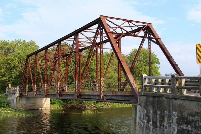
On Huron Street, 0.06 kilometers west of Union Street, on the left when traveling west.
Spanning the Generations
From the early days of settlement on the banks of the Grand River and its tributaries, bridges were important focal points for communities. Our significant heritage bridges have become distinctive landmarks that . . . — — Map (db m196213) HM
Like many pioneers of this district, the founder of Waterloo was a German Mennonite from Franklin County, Pennsylvania. In 1805 he purchased 900 acres of bush land on the site of this town. He settled here in 1806 and erected the first sawmill two . . . — — Map (db m244169) HM
The log schoolhouse is Waterloo's first school and one of the oldest remaining log schoolhouses in the Province of Ontario. Built in 1820, the school was originally located near the corner of King and Central Street on lands donated by Abraham Erb. . . . — — Map (db m244177) HM
On King Street South at Union Boulevard on King Street South.
The head office of The Mutual Life Assurance Company of Canada (now the head office of Sun Life Financial's Canadian operations) was completed in 1912. Designed by Canadian architect Frank Darling, of the Toronto firm Darling and Pearson, . . . — — Map (db m244191) HM
On Albert Street, 0.1 kilometers north of Bricker Avenue, on the right when traveling north.
On this site stands the first Lutheran seminary in Canada. This plaque commemorates the gift of five acres of land by the Board of Trade on behalf of the citizens of Waterloo on October 30, 1911, to the Evangelical Lutheran Seminary of Canada. The . . . — — Map (db m244140) HM
On Young Street West at Albert Street, on the right when traveling west on Young Street West.
This cairn erected to commemorate
the one hundredth anniversary
of the incorporation of Waterloo
as a village
Unveiled during the Centennial
celebrations held June 26 - July 1 1957 — — Map (db m244188) HM
On Ring Road at Seagram Drive, on the left when traveling east on Ring Road.
In 1956 community leaders, headed by Dr. J. Gerald Hagey, formed the Waterloo College Associate Faculties, a nondenominational corporation, to provide Waterloo with improved educational facilities, particularly in the technical, scientific and . . . — — Map (db m244166) HM
On Albert Street, 0.1 kilometers north of Bricker Avenue, on the right when traveling north.
Founded in 1911 as the Evangelical Lutheran Seminary of Canada, and situated on land donated by the Board of Trade of Waterloo, this institution was originally established to train homegrown Lutheran pastors. It was expanded in 1914 with . . . — — Map (db m244132) HM
On Rivers Edge Drive at Covered Bridge Drive, on the right when traveling north on Rivers Edge Drive.
This structure, the only remaining covered bridge in Ontario, was designed by John Bear in 1880, on the authority of Woolwich Township Council, to replace an earlier bridge over the Grand River. Built a year later by John and his brother, Benjamin, . . . — — Map (db m108716) HM