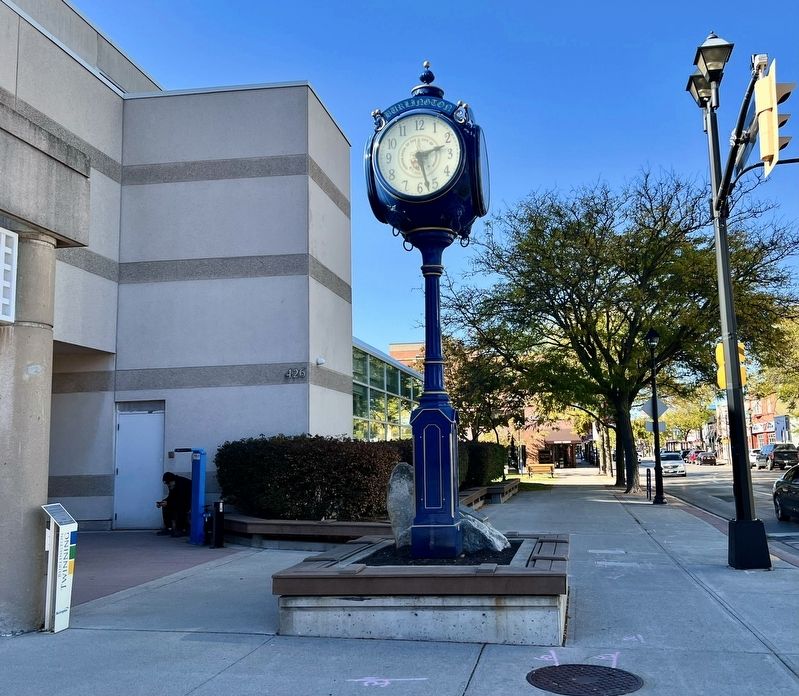
The City of Burlington donated a replica of this 125th anniversary clock to the City of Itabashi, Japan to commemorate the 10th anniversary of the twinning of the two cities. The replica in Itabashi is called the "Friendship Clock." A volunteer . . . — — Map (db m286437) HM
The intersection of Plains Road, Waterdown Road and Lasalle Park Road has always been a hub of activity and enterprise. The area surrounding these corners is rich in history and fabled for its market gardens. The settlement of Burlington Plains . . . — — Map (db m243820) HM
Dividing Burlington Bay from Lake Ontario, the beach strip forms a natural shortcut between Hamilton and Burlington. Beginning with a footpath created by generations of Indigenous peoples, this trail led to the development of roads and railway . . . — — Map (db m263772) HM
The original house on this site was built about 1800 by the famous Mohawk chief Joseph Brant (Thayendanegea). Two years previously Captain Brant had been granted some 3500 acres of land in this area for his military services to the Crown during . . . — — Map (db m233215) HM
This is the site of the famous Brant Inn where top North American entertainers and Big Bands from the 1930s to the 1960s performed. Crowds of well over a thousand people would fill the dance floor on a typical night. Music from the Brant Inn was . . . — — Map (db m243616) HM
Whatever the decade, a night at the Brant Inn was something special. Indeed, it was usually a special occasion - a birthday, an engagement, a chance to hear a famous American band - that prompted a visit.
The Brant Inn, most of all, was a . . . — — Map (db m248422) HM
Stretching 450 feet into Lake Ontario, the Brant Street Pier is one of Burlington's most iconic landmarks and is a key attraction within Spencer Smith Park.
In the 1800s, that space served a very different purpose. The 1877 Illustrated Atlas . . . — — Map (db m263789) HM
[east side]
In honour
of the men of Burlington
and
Nelson Township
who served in the Great War
1914 - 1919
1939 1945
In memory of the men and women of
Burlington and Nelson Township
who made the supreme sacrifice
in World War II . . . — — Map (db m287388) WM
St. Matthew's Church began in 1849 in the homes of local pioneers. In 1861 the land was donated for the original church by the Wyatt family. Funds for the church were donated by Matthew Clark, Lord Bayning in England and faithful parishioners. . . . — — Map (db m291126) HM
In 1798 Joseph Brant, the celebrated Mohawk War Chief, was given a Crown grant of 3,450 acres in this area. James Gage purchased land from the Brant Tract in 1810, and laid out a town site at the northern end of Burlington Beach from Brant Street . . . — — Map (db m221366) HM
On Tuesday March 1st 1898, a 4-coach Toronto-bound passenger express train departed Hamilton Stuart Street Station. At Burlington Junction, a 24-car coal train was parked on the siding, north of the double-tracked main line, waiting for the express . . . — — Map (db m243803) HM
Before cars, buses and the Queen Elizabeth Way, Burlington residents could get around using a futuristic intercity streetcar system! The Hamilton Radial Electric Railway (HRER) started operating in 1896, with service to Burlington beginning in . . . — — Map (db m243609) HM
Ireland House on Oakridge Farm was built in 1837 by Joseph Ireland, an immigrant from Yorkshire, England.
Constructed of local fieldstone, this house was the home of four generations of the Ireland family. Designated under the Ontario Heritage Act . . . — — Map (db m243813) HM
Before the 1960s, Burlington residents in need of medical treatment had to travel to Hamilton or Toronto or hope that their family doctor could make house calls! Circumstances changed in 1961 when the Joseph Brant Hospital was opened after a long, . . . — — Map (db m263770) HM
LA SALLE AT THE HEAD OF THE LAKE
In 1669 René-Robert Cavelier de La Salle, intent on reaching the Ohio River in order "not to leave to another the honour of finding the way to the Southern Sea, and thereby the route to China”, set out on . . . — — Map (db m221304) HM
Built in 1917 by The City of Hamilton on the former Wabasso Park Lands acquired in 1913, as a combination dance and picnic Pavilion. Its form of open verandah set between two arcaded pavilions decorated with pilasters, is characteristic of the Art . . . — — Map (db m243825) HM
In 1834, Collings Church, a frame building, was deeded over by Joseph Colling to the Trustees of Lowville Wesleyan Methodist Church for 5 shillings. By 1873 the present church was built and in 1925 it became Lowville United Church. The building is . . . — — Map (db m282184) HM
Welcome!
The Waterfront Trail stretches 350 km along the shore of Lake Ontario, connecting more than 28 communitites, 177 natural areas, 143 parks, 80 marinas, AND hundreds of historic places and festivals. The goal is a continuous 600 km . . . — — Map (db m273749) HM
Edythe MacKay, following the death in 1929 of her father, the prominent Hamilton industrialist Cyrus Birge, used her inheritance to replace the old Zimmerman farmhouse on her Shore Acres Estate. The design for her mansion, by Hamilton architect . . . — — Map (db m273766) HM
The map below, dated July 16, 1792, shows the Gore District (now Halton) as Mississauga of the Credit land. In 1795, under Treaty 8, the British granted 3,450 acres-later the Brant Tract- to Mohawk Chief Joseph Brant for his Loyalist service in . . . — — Map (db m290614) HM
In 1908 Burlington Council engaged Engineer, W. C. Chipman of Toronto to design a waterworks for the Village. The Water Commission members were: Maxwell Charles Smith (Reeve), J. S. Allen and W. J. Brush.
This Pumpbouse, built by E. Williamson . . . — — Map (db m262530) HM
St Luke's Church was built in 1834 on land originally patented by Chief Joseph Brant. Consecrated in 1838 by the Right Reverend C. J. Mountain, Anglican Bishop of Quebec, the church was a simple two-storey, frame building, with tower plain Gothic . . . — — Map (db m233233) HM
This important botanical garden is distinguished by its first class horticultural collection. Originating in the late 1920s, it developed as a series of discrete gardens and a wildlife conservation area within an urban context. Some of . . . — — Map (db m221298) HM
This granite post marked the 15 Mile point of the Hamilton
Herald "Around the Bay" Road Race, first run on Christmas Day 1894; it is the oldest footrace in North America. To this day runners pass this post on their way to the race finish in . . . — — Map (db m242275) HM
Erected to commemorate
the landing near this spot
September 1669
of
Sieur de la Salle
French explorer
believed to have been
the first white man to set foot
on these shores — — Map (db m286414) HM
Erected by the Burlington
Horticultural Society
in honour and memory
of
Spencer Smith
for his outstanding contribution
and leadership in the
beautification of Burlington
25 years on the Executive
during . . . — — Map (db m243617) HM
In 1920, town of Burlington property, from Nelson Avenue to Burlington Avenue, was drained, filled and designated as Lakeside Park. This was the beginning of the area now called Spencer Smith Park. Mr. Spencer Smith, who operated a grocery store on . . . — — Map (db m286415) HM
Kilometre 3582
Burlington July 13, 1980
Terry Fox
Marathon of Hope
"Even if I don't finish, we need others to continue.
It's got to keep going without me"
Burlington may not have been the beginning or the end of the Marathon of Hope, . . . — — Map (db m243612) HM
Sir James Yeo’s Strategic and Defensive Victory over Chauncey
After a United States naval victory on Lake Erie by Commodore Perry on September 10, 1813, a powerful American fleet of ten ships under Commodore Isaac Chauncey appeared off . . . — — Map (db m248427) HM
William Bunton was a prominent businessman in this area, formerly known as Wellington Square. He enjoyed great success as a land developer, grain and lumber merchant, owner of a general store and a ship builder. Schooners, built by Bunton's company . . . — — Map (db m286431) HM
At the 1954 Royal Agricultural Winter Fair in Toronto,
William E. Breckon of Burlington won the World Wheat
Championship with grain grown on his Nelson Township farm
about two miles north-east of here. He led the white winter
wheat class seven . . . — — Map (db m243606) HM