130 entries match your criteria. The first 100 are listed. The final 30 ⊳
DC, Art on Call Historical Markers
Historical markers that were installed in approximately 145 decommissioned call boxes in the District of Columbia by Cultural Tourism DC. Note that not all the markers issued by Cultural Tourism DC qualify for inclusion in the database, so we would not have all 145.
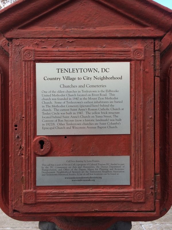
One of the oldest churches in Tenleytown is the Eldbrooke United Methodist Church located on River Road. This church was founded in 1840 as the Mount Zion Methodist Church. Some of Tenleytown's earliest inhabitants are buried in The Methodist . . . — — Map (db m112176) HM
In the 1700s and 1800s Tenleytown's origin as a crossroad generated numerous commercial activities, such as tobacco trade, farms, dairies, and slaughterhouses, along with the "Tennallytown" Tavern. Murdock Mill Road led from Tenleytown to an early . . . — — Map (db m112178) HM
As an early country village, Tenleytown inhabitants held occupations such as farmers, millers, tavern owners and shopkeepers. Since horses provided the primary method of transportation until the early 1900s, blacksmithing was a popular occupation in . . . — — Map (db m112179) HM
Until the 1920s, Cathedral Heights was richer in cows than people. The neighborhood was carved into plots of woodland and farms, including nearly 30 acres owned by Henry Kengla on which the Westchester Cooperative Apartments now stand. The Kengla . . . — — Map (db m126975) HM
The Washington National Cathedral, standing majestically on the commanding heights of the city, was not the first religious institution on Mount Alban. Joseph Nourse, a Revolutionary War veteran who moved his family to the site in 1813, dreamed . . . — — Map (db m152177) HM
In the early 20th century, small apartment buildings and houses were constructed on Macomb, Ordway, Porter, Quebec, and Rodman Streets. Another popular style on these streets was the Bungalow, one of many styles that could be ordered by mail from . . . — — Map (db m111607) HM
In 1912, renowned country house architect, Charles Adams Platt designed several buildings on this 20 acre country estate in collaboration with landscape architect Ellen Biddle Shipman.
Initially named The Causeway for its stone bridges . . . — — Map (db m112392) HM
Connecticut Avenue's commercial corridor, between Macomb and Ordway, reflects changes in retail that followed changes in modes of transportation from 1890 streetcar, to automobiles, to the Cleveland Park Metro Station in 1981. Individual stores . . . — — Map (db m149062) HM
In 1910, this was the site of a shed hosting a horse drawn chemical fire truck, an important amenity as the first houses in Cleveland Park were constructed mainly of wood, and the new suburb was far from city services. In 1916, the District . . . — — Map (db m112388) HM
Cleveland Park's lovely, hidden private gardens periodically open to the public in organized garden tours. These tours are but one of many results of the long history of resident collaboration. In the 1920s, the Cleveland Park Club and the . . . — — Map (db m112376) HM
An 1897 study for Washington, D.C. by the renowned landscape architecture firm of Frederick Law Olmstead influenced the layout of many streets in Cleveland Park. Rather than following the standard grid pattern, streets east of 34th Street (Reno . . . — — Map (db m112374) HM
1. Roma Restaurant - Mary Belcher
2. Commerce - Eleanor Oliver
3. The Broadmoor - John Simpson
4. Causeway at Tregaron - John Woo
5. Red Top - John Woo
6. Queen Anne Style - Di Stovall
7. Early Fire Fighting - Caitlin Werrell
8. . . . — — Map (db m112379)
Founded by Mary Day and her teacher, Lisa Gardner, in 1944, the Washington School of Ballet has grown from one studio on the first floor of this corner building into the headquarters of the Washington Ballet. The Washington Ballet is comprised of . . . — — Map (db m112378) HM
This 1898 Queen Anne style house is an outstanding example designed by Robert Thompson Head, the most prolific architect during the first phase of the Cleveland Park neighborhood's development. Between 1897 and 1901, Head designed houses for John . . . — — Map (db m112391) HM
Cleveland Park was named for Grover Cleveland who bought a country house on now Newark Street in 1886. In the 1890s, electrified streetcars ran on Connecticut and Wisconsin Avenues and led to the development of the Cleveland Park "suburb". . . . — — Map (db m112449) HM
The grand, 1,000 acre Rosedale Estate which was later subdivided to form Cleveland Park, was purchased by General Uriah Forrest, an aid-de-camp of General George Washington, who built a farmhouse in 1793. Between 1920-1959, the estate was owned . . . — — Map (db m112382) HM
Between 1903 and 1912, the second phase of Cleveland Park development featured houses in the Arts and Crafts style. Many of these were Sherman Cottages named for Ella Bennett Sherman, artist and wife of developer John Sherman. Smaller and less . . . — — Map (db m112390) HM
Cleveland Park derives it's name from it's most illustrious resident, President Grover Cleveland. In 1886, Cleveland purchased a stone farmhouse on the South side of now Newark Street, directly opposite Rosedale, which served as the Cleveland's . . . — — Map (db m112386) HM
The Broadmoor epitomizes the luxury apartment/hotels built along Connecticut Avenue in the 1920s. Designed in 1927 by prominent architect Joseph H. Abel, the Broadmoor featured a pioneering underground garage, restaurant and bar, beauty salon, . . . — — Map (db m111655) HM
Youth from the Latin American Youth Center - Art + Media House used cameras and microphones to explore the changing faces of Columbia Heights’ people and places. Collaborating with community artists, youth researched neighborhood history, . . . — — Map (db m126148)
Youth from the Latin American Youth Center–Art + Media House used cameras and microphones to explore the changing faces of Columbia Heights' people and places. Collaborating with community artists, youth researched neighborhood history, . . . — — Map (db m111852) HM
Youth from the Latin American Youth Center - Art + Media House used cameras and microphones to explore the changing faces of Columbia Heights’ people and places. Collaborating with community artists, youth researched neighborhood history, . . . — — Map (db m126149)
Youth from the Latin American Youth Center—Art + Media House used cameras and microphones to explore the changing faces of Columbia Heights' people and places. Collaborating with community artists, youth researched neighborhood history, . . . — — Map (db m129069) HM
Low cost housing in Mount Pleasant in the decades following World War II made it an ideal place for immigrants to the area. Refugees fleeing World War II and the Cold War in Eastern Europe were the first group to arrive. A small Czech community . . . — — Map (db m130866) HM
Youth from the Latin American Youth Center—Art + Media House used cameras and microphones to explore the changing faces of Columbia Heights' people and places. Collaborating with community artists, youth researched neighborhood history, . . . — — Map (db m129027) HM
On May 17, 1954, the U.S. Supreme Court made its historic decision in Brown vs. Board of Education to end segregation in public schools. One of the lawsuits that made up this decision involved the DC schools, and the following September, . . . — — Map (db m130863) HM
This painting is based on the little-known 1801 watercolor "President House" by J. Benford, part of The White House art collection.
Some art historians claim the large building on the right is not the White House, but Blodgett's Hotel, which . . . — — Map (db m120236) HM
This montage showing four presidential inaugural parades along 15th St., NW is based on artist Earl Minderman's 1980 visioning of President thomas Jefferson's inaugural parade as well as historic photos of the inauguration of Presidents Garfield, . . . — — Map (db m91808) HM
Fire Fact, November 28, 1911
DC's first motorized fire engine was placed in service at Engine Company 24. Its engine house was the first to be built without a stable and manure pit.
Caption: Fire Department information and images . . . — — Map (db m112658) HM
All the row houses in the 1700 block of Q St. (north and south pictured above) were built in the mid-1880s by one of Washington's most prolific architects/builders, Thomas Franklin Schneider. The prosperity and growth during the 1880s in DC . . . — — Map (db m80020) HM
Before the city built a bridge over Rock Creek at P St., this area was a favorite fording place. In fact, it was here that the Baltimore Light Dragoons and French units led by Lafayette, Count Rochambeau and Duc De Lauzan crossed Rock Creek . . . — — Map (db m98789) HM
Connecticut Ave. from Lafayette Square to Ashmead Place was just a well-worn trail for many years, after L'Enfant made it a prominent diagonal in his 1792 plan. The route was known as "the road to Holmead's" because of the family-owned . . . — — Map (db m93418) HM
Development in the neighborhood got its first start in 1871 when the Board of Public Works, under the leadership of Alexander “Boss” Robey Sheperd, installed sewers, paved roads, extended gas pipes and planted trees here . . . — — Map (db m113907) HM
From 1890 to 1910, some of the nation’s finest architects built mansions at or near Dupont Circle in Queen Anne, Richardsonian Romanesque, Italian Renaissance or Colonial Revival style.
Wealthy couples living elsewhere built most of the . . . — — Map (db m89393) HM
Myrtilla Miner (1815-1864), born near Brookfield, NY, was an idealistic white teacher who came to Washington to teach African Americans. In 1853, with funding from northern abolitionists, she paid $4,000 for a three-acre site at 20th and N . . . — — Map (db m89607) HM
Police Call Boxes such as this one (originally painted blue) were installed in the District after the Civil War. Officers on foot patrol used this secure telegraph system to contact the station, accessing the box with a now highly collectible . . . — — Map (db m112628) HM
Fire Fact, Sunday February 7, 1904
Great Baltimore Fire, several DC fire companies answered Baltimore Chief's urgent telegram, "Desperate fire here. Must have help at once." DC, responding by railway flatcar, was accompanied by New York . . . — — Map (db m112660) HM
The first houses south and west of Dupont Circle were built mostly of brick or brick and sandstone using Queen Anne, Chateauesqe, Richardsonian Romanesque or Georgian Revival styles. The Queen Anne style building at 1400 21st St. has a . . . — — Map (db m89569) HM
In the Gilded Age (1866-1901) the nouveau riche built grand mansions near Sheridan Circle and commissioned fashionable portraits such as this one of Mrs. Larz Anderson. They lived and entertained in these enormous residences during Washington's . . . — — Map (db m63723) HM
The mansion at 1801 Massachusetts Ave. was built in 1900 as a winter residence for the middle-aged Wadsworths, a childless couple from upstate New York. Martha helped design the block-sized mansion. During World War II it was used by the Red . . . — — Map (db m96299) HM
Theodore Roosevelt resided in a number of houses in Dupont Circle. Two still standing are 1215 19th St. and 1820 Jefferson St. In 1898, he lived at 1810 N St. (below, since razed). That year he led a volunteer cavalry called the Rough Riders . . . — — Map (db m96038) HM
This section of 15th St. and the east-west blocks meeting it were developed mainly from 1874 to 1887 by a group of speculative investors. The house at the corner of 15th and Q Sts. was built earlier, in 1864. St. Augustine's, Washington's first . . . — — Map (db m112663) HM
You are standing at the heart of the Dupont Circle Neighborhood, roughly bounded by 16th St., M St., Florida Ave. and Swann St. Early on, as the westernmost circle on L'Enfant's 1792 plan, the large park was called Pacific Circle. Like other . . . — — Map (db m96431) HM
A photo-collage celebrating The George Washington University's Permanent Collection incorporates a selection of outdoor sculpture and paintings. GW has enhanced the pedestrian environment in and around the Foggy Bottom campus.
Artists: . . . — — Map (db m111948)
Lisner Auditorium was built in 1946, boasting the biggest stage south of New York City. On its opening night, October 29, 1946, the famed 29 year-old actress Ingrid Bergman was starring in Joan of Lorraine. When Ms. Bergman found out that . . . — — Map (db m111543) HM
Beginning in 1892, streetcars ran from Chevy Chase Circle to downtown Washington, leading to development along Connecticut Avenue. In 1906, twelve houses were built on Tilden Street in a new neighborhood known then as "Fernwood Heights," now . . . — — Map (db m111656) HM
Forest Hills has two major cultural institutions in the neighborhood, the Hillwood Estate Museum & Gardens, and the Levine School of Music.
Built in 1926, the Hillwood Museum houses the remarkable collections of Marjorie Merriweather Post in . . . — — Map (db m114360) HM
Artist: Rebecca Osten
The Call Boxes in Forest Hills are located at Albemarle and 30th Street, Albemarle and Linnean, Connecticut and Tilden, Connecticut and Windom, Ellicott and 30th Place, Tilden and Linnean and the 2900 block of Upton . . . — — Map (db m114357)
In the 1820s, Isaac Peirce built the mill that exists today on land he purchased in 1794. In 1892, Rock Creek Park was established and the Federal Government acquired the mill.
Artist: Mary Belcher — — Map (db m114361) HM
In 1901, the National Bureau of Standards began developing a large complex of 89 buildings on 70 acres west of Connecticut Avenue near this site. The NBS was devoted to testing new materials and establishing industry standards. The NBS physicists . . . — — Map (db m114354) HM
Here the Nacotchtank Indians quarried soapstone and carved vessels. Archaeologist William Henry Holmes studied prehistoric workshops in this valley and other parts of the Rock Creek Watershed in the late 1800s and early 1900s.
Artist: Mary . . . — — Map (db m111605) HM
Almost a miniature Gothic cathedral, Christ Church behind you was built in 1885. It is the third building to occupy the spot since a group of Georgetown Episcopalians founded the parish in 1817. Among the founders were Francis Scott Key, author of . . . — — Map (db m113421) HM
Georgetown University, founded in 1789 by the Reverend John Carroll as a school for students of "Every Religious Profession," is the oldest Catholic university in America, administered by the Jesuits since 1805. According to the 1831 University . . . — — Map (db m121208) HM
You are standing at what has been the crossroads of Georgetown since Colonial times. George Town was laid out on the bluffs above the harbor on either side of Wisconsin Avenue. The avenue then was called Frederick Town Rolling Road because it was . . . — — Map (db m113647) HM
Georgetown's first African Americans were brought as slaves to labor for the tobacco industry and for domestic service in the houses of wealthy tobacco merchants. Others came as freed men and women before and after the Civil War. Over time, in . . . — — Map (db m113639) HM
At the turn of the 19th century, Yarrow Mamout, a slave granted his freedom a few years earlier, amassed $200 and purchased a piece of property and a house at what is now 3330-3332 Dent Place. Born in West Africa, Yarrow worked for 50 years for . . . — — Map (db m112139) HM
The citizens of Georgetown were already raising money for good causes two centuries ago. In 1796 the Mayor of Georgetown, Daniel Reintzel, was authorized to demolish a frame market house that stood on this site and erect a new brick market . . . — — Map (db m146212) HM
Among the first businesses in historic Georgetown were its inns and taverns. They not only offered food, drink and lodging, but were focal points of community life where political debate and civic meetings took place and business deals were made. . . . — — Map (db m121195) HM
Georgetown University Hospital, set atop a row of hills along Reservoir Road, promotes good health through patient care, research and education. Founded in 1898 and shaped by Georgetown's Catholic Jesuit heritage, the hospital consistently has . . . — — Map (db m113906) HM
You are standing in the heart of a once thriving African American community. At the time of the American Revolution in 1776, one third of Georgetown's population was African American. By the time of the Civil War in the 1860s, many former slaves . . . — — Map (db m110018) HM
Georgetown citizens have been central to preserving Georgetown's important historic houses. Three of these houses, built at the turn of the 19th century on large plots of land overlooking the port, are now accessible to the public and are . . . — — Map (db m113643) HM
Georgetown began in the 1740s as a tobacco port, where ships departed for Britain, Europe and the West Indies filled with flour, lumber, coal, grain and, above all, tobacco. The fine harbor brought visitors and goods and, with them, prosperity . . . — — Map (db m113415) HM
"Holy Hill," the site of Georgetown University, the Convent of the Visitation, and Holy Trinity Church, has been the center of Catholic spiritual life in the nation's capital since its beginnings in the late-18th century.
Shortly after the . . . — — Map (db m112129) HM
The early mansions of wealthy ship owners, merchants and land speculators in this part of Georgetown were built high above the Potomac River with fine views, or prospects, of the harbor filled with ships and the wilds of Virginia on the other . . . — — Map (db m113401) HM
Georgetown has been a performance hub for musicians in a wide range of popular genres — jazz, folk, blues, bluegrass, country, and rock.
During the 1960s and 1970s the Cellar Door, at the corner of 34th and M Streets, featured artists . . . — — Map (db m112123) HM
M Street has always been heavily traveled. In 1795 this prompted passage of the first local speeding law, making it illegal to gallop horses on M Street. Back in 1634, things were quieter. Then, Englishman Henry Fleet wrote of finding "deer, . . . — — Map (db m97704) HM
Georgetown Visitation Preparatory School, straight ahead in the next block, is one of the oldest Catholic institutions in America. It was founded in 1799 by three pious ladies under the spiritual guidance of the president of Georgetown College, . . . — — Map (db m112132) HM
Step across the cobblestone street and trolley tracks of a bygone era and look up at the façade of St. John's Church, Georgetown Parish, designed in the Federal style by William Thornton, architect of the Capitol. This Episcopal parish, . . . — — Map (db m112133) HM
Hidden behind the grand houses of N Street — and many others large and small — are tranquil walled gardens with brick terraces, old shade trees, lily ponds, swimming pools, and a tennis court or two.
Behind you stands the Edes Home, . . . — — Map (db m113641) HM
The imposing classic revival building on the hill is the Duke Ellington School of the Arts, formerly Western High School. It was completed in 1898 as a "temple of learning" and was among the first public senior high schools in Washington.
. . . — — Map (db m112146) HM
The first house of worship in Georgetown — a town dominated by Presbyterian Scots — was a log church built in 1769 by a Lutheran congregation where the present Lutheran church now stands (opposite). The Presbyterian Burial Ground, once . . . — — Map (db m120508) HM
Before there was a DC Fire Department, companies from two then-separate towns — Georgetown and Washington — provided local fire protection. In 1789, Georgetown citizens purchased a hand-pumped engine and fire buckets with funds raised . . . — — Map (db m113420) HM
In 1608 Captain John Smith sailed up the Potomac, the first European to lay eyes on this site. At that time, ships could sail up to this point, and beautiful bluffs led down to the water. Algonquin Indians lived here in great numbers, drawn by . . . — — Map (db m110015) HM
Considered the father of Rock Creek Park and the National Zoo, Washington banker and philanthropist Charles Carroll Glover (1846-1936) also gave Washington, D.C. 77 acres in the valley of Foundry Branch, just west of this neighborhood. With an . . . — — Map (db m113376) HM
Dischord Records is a Washington, D.C. independent record label born right here on Beecher Street in 1980. The label focuses on the independent punk music scene in the Washington area and offers musicians an alternative to major labels. By . . . — — Map (db m113373) HM
For years Hall Place was home to many astronomers who worked nearby at the United States Naval Observatory. One of the most celebrated was Herbert R. Morgan (1875-1957), a longtime resident of Glover Park. He bought one of the first homes on Hall . . . — — Map (db m113378) HM
Police and fire call boxes were installed throughout Washington, D.C. neighborhoods to provide emergency communication links between neighborhood streets and local police and fire stations. With the introduction of the 911 emergency call system . . . — — Map (db m113384) HM
Ahead on the hill is Holy Rood Cemetery, the first Catholic parish cemetery in Washington. Established by Georgetown's Holy Trinity Church in 1832, the cemetery contains the remains of more than 7,300 whites and African Americans, both enslaved and . . . — — Map (db m113385) HM
Tunlaw Road first appeared in official records in 1879. It was named after Tunlaw Farm, now the Wesley Heights neighborhood, which took its name from a prominent walnut tree on the property. The owner spelled the name of his favorite tree . . . — — Map (db m113381) HM
The community gardens at 42nd Street and Tunlaw Road and in Whitehaven Park were established as part of the Federal National Victory Garden Program during World War II as a way for average Americans to contribute to the war effort. These gardens . . . — — Map (db m113380) HM
Pierre L'Enfant's plan for the Federal City in 1791 included a church, “for national purposes,” but it was not until 1893 that the Protestant Episcopal Cathedral Foundation was given a charter to establish a cathedral. Located on Mount . . . — — Map (db m87907) HM
As Washington expanded to the Northwest in the 1920s, modest homes were built on farmland in an area known first as Fairview Heights and then as Cathedral Heights, north of Fulton Street and west of Wisconsin Avenue. A Greek family recognized the . . . — — Map (db m120510) HM
A Cinderella world once existed behind the stone wall you see straight ahead, occupied by Evalyn Walsh McLean.
Evalyn was the only daughter of multimillionaire Thomas F. Walsh — he struck gold in Colorado — and Carrie Bell Reed, a . . . — — Map (db m88717) HM
Friendship was the country estate for two generations of the McLean family. The English style manor house “Eden Bower” was built around 1800 by British Col. Richard Pyle. Pyle was succeeded by Georgetown University, which used the . . . — — Map (db m152176) HM
In the late nineteenth century, a rural retreat called the Woodley Inn rose near what became Massachusetts Avenue and 38th Street. Before the advent of air conditioning, wealthy families summered on the heights overlooking the city to escape the . . . — — Map (db m112151) HM
Since the 1700s, Tenleytown has served as a transportation hub, a role that is undiminished today. Tenleytown was strategically located at an early crossroad for travel and trade to Maryland and Virginia. Wisconsin Avenue follows a natural . . . — — Map (db m112174) HM
Even before the United States entered World War II in 1941, thousands of workers from across the country streamed into Washington to fill new military and government jobs. The swelling population needed more housing, and, to accommodate them, . . . — — Map (db m111891) HM
In May 1864, a year before the Civil War ended, Union and Rebel troops clashed in a series of bloody battles in Virginia. Steamships loaded with the wounded traveled up the Potomac River to Washington where stretchers piled ashore for days and . . . — — Map (db m111885) HM
By the late 17th century, English colonial settlements and tobacco plantations had reached what is now Washington, DC. By the 1750s the ports of Alexandria and Georgetown were built, and soon afterward a series of mills expanded along Rock Creek . . . — — Map (db m112586) HM
During the second half of the 20th century, housing in Mount Pleasant was relatively affordable. Recent immigrants, students, young professionals, and families from diverse economic backgrounds populated the neighborhood. In 1986, residents . . . — — Map (db m130883) HM
In 1609 Captain John Smith sailed from the English colony of Jamestown, Virginia, and up the Potomac River as far as Little Falls. He found 13 Indian villages along the Potomac, including one called Nacotchtank. These villagers farmed small plots . . . — — Map (db m130871) HM
Until 1900 Mount Pleasant was still a small village of wood-frame houses about a mile outside the City of Washington. In 1903 the city extended and broadened 16th Street, separating what is now Columbia Heights from Mount Pleasant. At about the . . . — — Map (db m114769) HM
Early Tenleytown homes still standing today were built mostly in the 1890s along paths used by farmers and dairymen. The homes in the Grand Road Historic District (pictured here) are typical of these early dwellings, as are the homes along Belt . . . — — Map (db m112188) HM
The Tenleytown Firehouse (pictured here) dates to 1903. Its location on Wisconsin Avenue near Tenley Circle provides access and coverage to the greater Tenleytown area. Prior to the introduction of motor driven fire vehicles in the 1920s, the . . . — — Map (db m111344) HM
Designated a D.C. Landmark in 1960, the Rest (pictured here) is Tenleytown's oldest residence (built around 1800) and is located at the corner of Windom Place and 39th Street. Local legend maintains that the bricks for the house were brought over . . . — — Map (db m112187) HM
Sheridan-Kalorama's grand mansions, in a variety of architectural styles, are the work of many prominent architects. In 1910 Jules Henri de Sibour designed the stately mansion at 2221 Kalorama Rd. for a mining magnate. It is now the home of the . . . — — Map (db m112607) HM
Three chief justices of the Supreme Court lived in Sheridan-Kalorama. William Howard Taft, appointed Chief Justice after his presidency, lived at 2215 Wyoming Ave. Charles Evans Hughes, a U.S. Secretary of State and an unsuccessful candidate for . . . — — Map (db m112605) HM
Surrounding you are some of the 75 embassies, chanceries and diplomatic residences that lend a vibrant international presence to Sheridan-Kalorama. The practice of diplomacy — the conduct of relations among nations that involves negotiating . . . — — Map (db m113371) HM
Educational institutions are part of Sheridan-Kalorama's history. Across the street is Our Lady Queen of the Americas Catholic Church. Built in 1904, it housed St. Rose's Industrial School, where orphaned girls were taught home economics. Later St. . . . — — Map (db m112608) HM
130 entries matched your criteria. The first 100 are listed above. The final 30 ⊳