213 entries match your criteria. The first 100 are listed. ⊳
Tennessee, The Historical Commission of Metropolitan Nashville and Davidson County Historical Markers
By Duane and Tracy Marsteller, March 8, 2020
Alfred Z. Kelley Marker
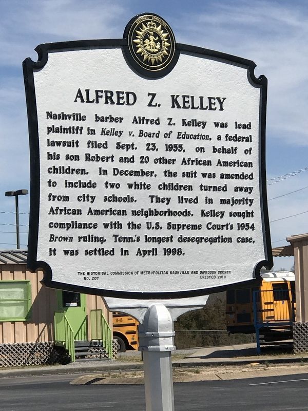
| 1 ► Tennessee, Davidson County, Antioch — 207 — Alfred Z. Kelley — |
| On Blairfield Drive, on the right when traveling east. | |||
| 2 ► Tennessee, Davidson County, Antioch — 164 — Antioch Pike |
| On Antioch Pike, 0.1 miles north of Goodwin Road, on the right when traveling north. Reported missing. | |||
| 3 ► Tennessee, Davidson County, Antioch — 21 — Cane Ridge Cumberland Presbyterian Church — |
| On Old Hickory Boulevard, 0.1 miles east of Cane Ridge Road, on the right when traveling west. | |||
| 4 ► Tennessee, Davidson County, Antioch — 165 — Locust Hill — |
| On Reeves Road, 0.1 miles east of McBride Road, on the left when traveling east. | |||
| 5 ► Tennessee, Davidson County, Antioch — 209 — Olive Branch Missionary Baptist Church — |
| On Cane Ridge Road, 0.4 miles north of Old Hickory Boulevard, on the right when traveling north. | |||
| 6 ► Tennessee, Davidson County, Donelson — 10 — Two Rivers Mansion — |
| On McGavock Pike at Stones River Road, on the left when traveling north on McGavock Pike. | |||
| 7 ► Tennessee, Davidson County, Donelson, Stanford Estates — 63 — Clover Bottom Mansion — |
| Near Lebanon Pike (U.S. 70) at Rivercrest Pass. | |||
| 8 ► Tennessee, Davidson County, Germantown — 179 — Germantown Brewery District — |
| On 5th Avenue North at Madison Street, on the right when traveling north on 5th Avenue North. | |||
| 9 ► Tennessee, Davidson County, Goodlettsville — 72 — Mansker’s First Fort — |
| On Long Hollow Pike (Tennessee Route 174), on the right when traveling east. | |||
| 10 ► Tennessee, Davidson County, Goodlettsville, Parkway — 185 — Patsy Cline's Dream House — |
| On Nella Drive, 0.1 miles west of Green Acres Drive, on the left when traveling west. | |||
| 11 ► Tennessee, Davidson County, Hermitage — 32 — Blackwood Field — |
| On Shute Lane at Lebanon Pike (U.S. 70), on the left when traveling north on Shute Lane. | |||
| 12 ► Tennessee, Davidson County, Hermitage — 187 — Dodson School — |
| On Chandler Road, 0.1 miles north of Summit Run Place, on the right when traveling north. | |||
| 13 ► Tennessee, Davidson County, Joelton — 166 — Paradise Ridge — |
| On Morgan Road, 0.6 miles east of Whites Creek Pike (U.S. 431), on the left when traveling east. | |||
| 14 ► Tennessee, Davidson County, Madison — 29 — Madison College — |
| On Hospital Drive, 0.1 miles north of Neelys Bend Road, on the left when traveling north. | |||
| 15 ► Tennessee, Davidson County, Madison — 13 — Mrs. John Donelson — |
| On Gallatin Pike North (U.S. 31E) at Rivergate Parkway, on the right when traveling south on Gallatin Pike North. | |||
| 16 ► Tennessee, Davidson County, Madison — 172 — Odom's Tennessee Pride Sausage, Inc. — |
| On Neelys Bend Road just north of Nix Pass, on the right when traveling north. | |||
| 17 ► Tennessee, Davidson County, Madison — 171 — Smith-Carter House — |
| On Gibson Drive, 0.2 miles north of Due West Avenue, on the left when traveling north. | |||
| 18 ► Tennessee, Davidson County, Nashville — 134 — Battle of Nashville — (December 16, 1864) — Confederate Final Stand — |
| On Tyne Boulevard, on the right when traveling east. | |||
| 19 ► Tennessee, Davidson County, Nashville — 216 — Brewery at Mill Creek — |
| On Elm Hill Pike west of Massman Drive, on the right when traveling east. | |||
| 20 ► Tennessee, Davidson County, Nashville — 192 — Cockrill Bend — |
| On Centennial Boulevard at Bomar Boulevard, on the right when traveling north on Centennial Boulevard. | |||
| 21 ► Tennessee, Davidson County, Nashville — 115 — Ezell House — |
| On Donelson Pike (State Highway 255) at Ezell Road, on the right when traveling north on Donelson Pike. | |||
| 22 ► Tennessee, Davidson County, Nashville — 198 — Hillwood Estates — |
| On Post Road at Davidson Road, on the right when traveling south on Post Road. | |||
| 23 ► Tennessee, Davidson County, Nashville — 99 — Lake Providence Community — |
| On Nolensville Pike (Alternate U.S. 31) at Winston Avenue West, on the right when traveling south on Nolensville Pike. | |||
| 24 ► Tennessee, Davidson County, Nashville — 86 — Luke Lea Heights — 5 miles ahead on Scenic Drive — |
| On Belle Meade Boulevard at Warner Park Entrance. | |||
| 25 ► Tennessee, Davidson County, Nashville — 168 — May-Granbery House and Alford Cemetery — |
| On Hill Road at Granbery Park Drive, on the left when traveling west on Hill Road. | |||
| 26 ► Tennessee, Davidson County, Nashville — 78 — Percy Warner Park — 2058.1 acres — |
| On Belle Meade Boulevard at Warner Park Entrance. | |||
| 27 ► Tennessee, Davidson County, Nashville — 175 — Tennessee Hospital for the Insane — |
| On Murfreesboro Pike (U.S. 41) at Dell Parkway, on the right when traveling south on Murfreesboro Pike. | |||
| 28 ► Tennessee, Davidson County, Nashville — 230 — Tennessee/Spring Water Brewery — |
| On Air Freight Boulevard at Vultee Boulevard, on the right when traveling north on Air Freight Boulevard. | |||
| 29 ► Tennessee, Davidson County, Nashville, Antioch — 244 — Alice Thompson Collinsworth — 1777-1828 — |
| On Crossings Boulevard west of Mt. View Road, on the right when traveling west. | |||
| 30 ► Tennessee, Davidson County, Nashville, Arts District — 88 — Tennessee Ornithological Society — |
| On Union Street at 5th Avenue, on the left when traveling north on Union Street. | |||
| 31 ► Tennessee, Davidson County, Nashville, Belle Meade Links — 121 — Belle Meade Golf Links Historic District — |
| On Windsor Drive at Blackburn Avenue, on the left when traveling west on Windsor Drive. | |||
| 32 ► Tennessee, Davidson County, Nashville, Belle Meade Links — 129 — Parmer School — |
| On Leake Avenue at Park Hill Drive, on the right when traveling west on Leake Avenue. | |||
| 33 ► Tennessee, Davidson County, Nashville, Bellevue — 178 — Centenary United Methodist Church / Rev. William Gower (1776-1851) — |
| On Gower Road, 0.1 miles north of Hickory Trail Drive, on the right when traveling north. | |||
| 34 ► Tennessee, Davidson County, Nashville, Bellevue — 80 — Edwin Warner Park — 606.7 acres — |
| Near Tennessee Route 100, 0.4 miles west of Old Hickory Road (Tennessee Highway 254), on the left when traveling west. | |||
| 35 ► Tennessee, Davidson County, Nashville, Bellevue — 138 — Hill Forest — |
| On U.S. 70S at Brookmont Terrace, on the right when traveling west on U.S. 70S. | |||
| 36 ► Tennessee, Davidson County, Nashville, Bellevue — 214 — The Myhr House — (Maple Row) — |
| On Myhr Green at Bradford Green, on the right when traveling south on Myhr Green. | |||
| 37 ► Tennessee, Davidson County, Nashville, Breeze Hill — 118 — Sunnyside — |
| Near Kirkwood Avenue at Granny White Pike. | |||
| 38 ► Tennessee, Davidson County, Nashville, Burton Valley — 5 — Battle of Nashville — Shy's Hill — |
| On Benton Smith Road, on the right when traveling south. | |||
| 39 ► Tennessee, Davidson County, Nashville, Cherokee Park — 58 — Montgomery Bell Academy — |
| On Harding Road (U.S. 70S) at Cherokee Road, on the right when traveling east on Harding Road. | |||
| 40 ► Tennessee, Davidson County, Nashville, Chestnut Hill — 229 — Dudley Park — |
| On 3rd Avenue South south of Chestnut Street, on the right when traveling south. | |||
| 41 ► Tennessee, Davidson County, Nashville, Chestnut Hill — 91 — St. Patrick Catholic Church — |
| On 2nd Avenue South (US 41A). | |||
| 42 ► Tennessee, Davidson County, Nashville, Crieve Hall — 205 — Crieve Hall — |
| On Hogan Road, 0.1 miles east of Trousdale Drive, on the left when traveling east. | |||
| 43 ► Tennessee, Davidson County, Nashville, Donelson — 130 — Buchanan Log House — |
| On Elm Hill Pike at Hurt Drive, on the right when traveling west on Elm Hill Pike. | |||
| 44 ► Tennessee, Davidson County, Nashville, Donelson Hills — 181 — The Logue House — (Logue Haven) — |
| On Lebanon Road (U.S. 70) at Cottage Lane, on the right when traveling west on Lebanon Road. | |||
| 45 ► Tennessee, Davidson County, Nashville, Downtown — 225 — Berger Building / WDAD Radio Station “Where Dollars are Doubled” — |
| On U.S. 431 just north of Commerce Street, on the right when traveling north. | |||
| 46 ► Tennessee, Davidson County, Nashville, Downtown — 83 — Black Churches of Capitol Hill — |
| On Charlotte Avenue at McLemore Avenue, on the right when traveling west on Charlotte Avenue. | |||
| 47 ► Tennessee, Davidson County, Nashville, Downtown — 226 — Campaign for the Vote — |
| On Church Street at Anne Dallas Dudley Boulevard, on the left when traveling east on Church Street. | |||
| 48 ► Tennessee, Davidson County, Nashville, Downtown — 96 — Christ Church Cathedral / Old Christ Church (1831~1890) |
| On Broadway. Reported missing. | |||
| 49 ► Tennessee, Davidson County, Nashville, Downtown — 235 — Gerst House — 315 2nd Ave N — |
| On Union Street at 2nd Avenue North, on the right when traveling west on Union Street. | |||
| 50 ► Tennessee, Davidson County, Nashville, Downtown — 232 — John Robert Lewis — Feb. 21, 1940 - July 17, 2020 — |
| On Commerce Street just west of St. Cloud Alley, on the left when traveling west. | |||
| 51 ► Tennessee, Davidson County, Nashville, Downtown — 87 — Nashville Sit-Ins — |
| On Rosa Parks Blvd at Charlotte Avenue on Rosa Parks Blvd. | |||
| 52 ► Tennessee, Davidson County, Nashville, Downtown — 60 — Nashville YMCA — |
| On Church Street at YMCA Way, on the right when traveling west on Church Street. | |||
| 53 ► Tennessee, Davidson County, Nashville, Downtown — 12 — Nashville's First Public School — |
| On Broadway close to U.S. 41. | |||
| 54 ► Tennessee, Davidson County, Nashville, Downtown — 120 — Randall Jarrell — 1914~1965 — |
| On Broadway at 7th Avenue on Broadway. | |||
| 55 ► Tennessee, Davidson County, Nashville, Downtown — 210 — Rev. Nelson G. Merry — "Nashville's First Ordained African American Minister" — 1824-1884 — |
| On Nelson Merry Street at 10th Avenue North, on the right when traveling east on Nelson Merry Street. | |||
| 56 ► Tennessee, Davidson County, Nashville, Downtown — 3 — Site of First Store |
| On 2nd Avenue North, on the right when traveling north. Reported permanently removed. | |||
| 57 ► Tennessee, Davidson County, Nashville, Downtown — 184 — The Jungle and Juanita's — First Gay Bars in Nashville — |
| On Commerce Street just east of Rosa L. Parks Boulevard (U.S. 31), on the right when traveling east. | |||
| 58 ► Tennessee, Davidson County, Nashville, Downtown — 135 — The Seeing Eye — Independence and Dignity Since 1929 — |
| On 3rd Avenue North, on the right when traveling north. | |||
| 59 ► Tennessee, Davidson County, Nashville, Downtown — 25 — Transfer Station Site — |
| On Deaderick Street at 3rd Avenue North, on the left when traveling east on Deaderick Street. | |||
| 60 ► Tennessee, Davidson County, Nashville, Downtown — 84 — Union Station — |
| On Broadway at 10th Avenue, on the right when traveling east on Broadway. | |||
| 61 ► Tennessee, Davidson County, Nashville, Downtown — 85 — Vine Street Temple — |
| On Commerce Street at 7th Avenue North, on the left when traveling east on Commerce Street. | |||
| 62 ► Tennessee, Davidson County, Nashville, Downtown — 94 — Votes for Women — |
| On Capitol Boulevard at Union Street on Capitol Boulevard. | |||
| 63 ► Tennessee, Davidson County, Nashville, Downtown — 109 — Ward's Seminary — |
| On Rosa L. Parks Boulevard (U.S. 31) south of Church Street, on the right when traveling south. | |||
| 64 ► Tennessee, Davidson County, Nashville, East Bank — 7 — East Nashville Fire — |
| On North 1st Street north of Oldham Street, on the right when traveling north. | |||
| 65 ► Tennessee, Davidson County, Nashville, East Bank — 158 — Surrender of Nashville East Bank of the Cumberland — |
| On Titans Way at Victory Avenue, on the right when traveling south on Titans Way. | |||
| 66 ► Tennessee, Davidson County, Nashville, East Nashville — 66 — Cornelia Fort Airport — |
| On Shadow Lane, 0.1 miles north of Airpark Drive, on the right when traveling north. | |||
| 67 ► Tennessee, Davidson County, Nashville, East Nashville — 124 — First Baptist Church — East Nashville — |
| On Main Street just east of North 6th Street, on the left when traveling east. | |||
| 68 ► Tennessee, Davidson County, Nashville, East Nashville — 180 — Rock City — |
| On Ann Street at Rock City Street, on the right when traveling west on Ann Street. | |||
| 69 ► Tennessee, Davidson County, Nashville, Eastwood — 170 — Eastland / Cora Howe’s “Wildings” — |
| On Greenwood Avenue, 0.1 miles west of Scott Avenue, on the right when traveling west. | |||
| 70 ► Tennessee, Davidson County, Nashville, Edgehill — 68 — Edmondson Home Site — |
| On 14th Avenue South north of Wade Avenue, on the right. | |||
| 71 ► Tennessee, Davidson County, Nashville, Edgehill — 77 — Fall School — |
| On 8th Avenue South (U.S. 31) at Chestnut Street, on the right when traveling north on 8th Avenue South. | |||
| 72 ► Tennessee, Davidson County, Nashville, Edgehill — 203 — Rev. Bill Barnes — 1931-2017 — |
| On Edgehill Avenue at 15th Avenue South, on the left when traveling east on Edgehill Avenue. | |||
| 73 ► Tennessee, Davidson County, Nashville, FANG — 213 — Clark Memorial United Methodist Church — |
| On 14th Avenue North at Phillips Street, on the right when traveling north on 14th Avenue North. | |||
| 74 ► Tennessee, Davidson County, Nashville, Fisk/Meharry — 242 — Dr. Josie E. Wells — 1876-1912 — |
| On Doctor DB Todd Junior Boulevard north of Albion Street, on the right when traveling south. | |||
| 75 ► Tennessee, Davidson County, Nashville, Fisk/Meharry — 189 — Dr. Matthew Walker Sr. — 1906-1978 — |
| On Jefferson Street at 14th Avenue North, on the left when traveling west on Jefferson Street. | |||
| 76 ► Tennessee, Davidson County, Nashville, Fisk/Meharry — 19 — Meharry Medical College — |
| On Dr. D. B. Todd, Jr. Blvd. at Meharry Blvd, on the right when traveling south on Dr. D. B. Todd, Jr. Blvd.. | |||
| 77 ► Tennessee, Davidson County, Nashville, Gateway Acres — 9 — Battle of Nashville — Stewart's Line |
| On Lealand Lane north of Stonewall Drive, on the right when traveling north. Reported missing. | |||
| 78 ► Tennessee, Davidson County, Nashville, Gateway Acres — 132 — Dry-Stack Stone Walls — |
| On Granny White Pike, on the right when traveling north. | |||
| 79 ► Tennessee, Davidson County, Nashville, Germantown — 73 — Assumption Church / Cardinal Stritch — |
| On 7th Avenue North. | |||
| 80 ► Tennessee, Davidson County, Nashville, Germantown — 159 — Centenary Methodist Institute — |
| On Monroe Street east of 7th Avenue North, on the left when traveling east. | |||
| 81 ► Tennessee, Davidson County, Nashville, Germantown — 114 — Germantown Historic District — |
| On Jefferson Steet near 6th Avenue North, on the right when traveling west. | |||
| 82 ► Tennessee, Davidson County, Nashville, Germantown — 146 — Mary Catherine Schweiss Strobel — (1912-1986) — |
| On 7th Avenue North, 0.1 miles north of Madison Street, on the right when traveling north. | |||
| 83 ► Tennessee, Davidson County, Nashville, Glencliff — 201 — Turner Grammar School — |
| On Nolensville Pike (Alternate U.S. 31) south of Timmons Street, on the right when traveling south. | |||
| 84 ► Tennessee, Davidson County, Nashville, Green Hills — 89 — Battle of Nashville Confederate Line — |
| On Woodmont Boulevard at Hopkins Street, on the right when traveling west on Woodmont Boulevard. | |||
| 85 ► Tennessee, Davidson County, Nashville, Green Hills — 31 — First Airfield |
| On Hampton Avenue west of 23rd Avenue, on the right when traveling east. Reported missing. | |||
| 86 ► Tennessee, Davidson County, Nashville, Green Hills — 21 — Glendale Park — |
| On Lealand Lane at Tower Place, on the right when traveling north on Lealand Lane. | |||
| 87 ► Tennessee, Davidson County, Nashville, Green Hills — 38 — John Trotwood Moore — 1858-1929 — |
| On Granny White Pike at Lone Oak Road, on the right when traveling south on Granny White Pike. | |||
| 88 ► Tennessee, Davidson County, Nashville, Green Hills — 18 — Johnson's Station — |
| On Harding Pike (U.S. 70S) at Vine Court, on the right when traveling west on Harding Pike. | |||
| 89 ► Tennessee, Davidson County, Nashville, Green Hills — 103 — Julia McClung Green — 1873-1961 — |
| On Hobbs Road east of Wallace Lane, on the right when traveling west. | |||
| 90 ► Tennessee, Davidson County, Nashville, Green Hills — 183 — Kenner Manor Historic District — |
| On Woodmont Circle at Kenner Avenue, in the median on Woodmont Circle. | |||
| 91 ► Tennessee, Davidson County, Nashville, Green Hills — 111 — The Harpeth Hall School — |
| On Hobbs Road west of Estes Road, on the right when traveling east. | |||
| 92 ► Tennessee, Davidson County, Nashville, Green Hills — 237 — Vine Street Christian Church — 4101 Harding Pike — |
| On Harding Pike (U.S. 70S) west of Vine Court, on the right when traveling west. | |||
| 93 ► Tennessee, Davidson County, Nashville, Green Hills — 104 — Woodmont Estates — |
| On Valley Brook Road at Bear Road, in the median on Valley Brook Road. | |||
| 94 ► Tennessee, Davidson County, Nashville, Greenwood — 220 — School Desegregation in Nashville / Hattie Cotton Elementary School — |
| On West Greenwood Avenue west of Bailey Street, on the right when traveling west. | |||
| 95 ► Tennessee, Davidson County, Nashville, Hadley Park — 193 — Club Baron — |
| On Jefferson Street, 0.1 miles west of 26th Avenue North, on the right when traveling west. | |||
| 96 ► Tennessee, Davidson County, Nashville, Harpeth Valley Park — 197 — Historic Bellevue — |
| On Old Harding Pike, 0.1 miles east of Harpeth Parkway West, on the left when traveling east. | |||
| 97 ► Tennessee, Davidson County, Nashville, Haynes Area — 1 — Heaton's Station — |
| On Lock Road at Baptist World Center Drive, on the left when traveling south on Lock Road. | |||
| 98 ► Tennessee, Davidson County, Nashville, Haynes Area — 167 — Riverside Sanitarium and Hospital / Dorothy Lavinia Brown, M.D. — /(1919-2004) — |
| On Youngs Lane, 0.2 miles west of Baptist World Center Drive, on the left when traveling west. | |||
| 99 ► Tennessee, Davidson County, Nashville, Hillsboro West End — 217 — Bradley Recording Studio Hillsboro Village — |
| On #802 Alley at 21st Avenue S (Tennessee Highway 106), on the right when traveling east on #802 Alley. | |||
| 100 ► Tennessee, Davidson County, Nashville, Hillsboro West End — 191 — Elizabeth Atchison Eakin — 1858-1936 — |
| On Fairfax Avenue at 25th Avenue South, on the right when traveling west on Fairfax Avenue. | |||
213 entries matched your criteria. The first 100 are listed above. Next 100 ⊳