Pleasant Grove A.M.E. Church was organized June 29, 1869 at Taylors Creek, GA. Rev. Piner Martin was the first pastor. The first church, a small frame house, was named A.M.E. Church of the U.S.A. Sixteen acres of land were later purchased to build a . . . — — Map (db m15709) HM
On 1st Avenue, 0 miles north of 12th Street, on the right when traveling south.
Near here, in July 1872, the first local public school for black students was opened. The school was the result of an action by the City Council directing the Trustees of the Columbus Public Schools to set up classes for blacks. For the first of . . . — — Map (db m23120) HM
On 9th Street at 6th Avenue, on the right when traveling west on 9th Street.
Side 1:
In 1901, George Foster Peabody and his brothers made an offer to the colored men and boys of Columbus to build a YMCA on the condition they raise $1,000, purchase a building lot and get membership of 300 men. On Sunday, . . . — — Map (db m57806) HM
On Radcliff Avenue, 0 miles north of Martin Luther King Avenue, on the left when traveling north.
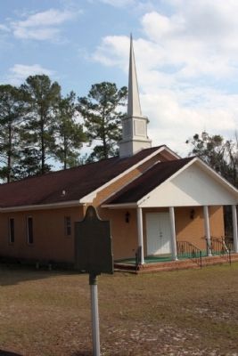
In the fall of 1914 Radcliff School was organized in Allen Temple A.M.E. Church. At that time it was known as Wynnton Hill School. J. L. Bond was principal and the first head teacher was Mrs. S. A. Cody. When the building burned, the school was . . . — — Map (db m22409) HM
On 5th Avenue at Linwood Boulevard, on the right when traveling north on 5th Avenue.
This one-story Victorian Gothic structure dates back to 1870. The cornerstone of the church indicates that the building was constructed in 1870 with the basement added in 1890. This suggests that the original wooden church was raised, a basement . . . — — Map (db m45599) HM
On Sixth Avenue, on the right when traveling north.
St. James African Methodist Episcopal Church was organized in 1863. The present church is built on land granted by act of the Georgia Legislature in 1873. It was erected in 1876 under the pastorate of Rev. Wesley J. Gaines, at a cost of $20,000. . . . — — Map (db m45680) HM
On Bishop Johnson Circle (County Route 61) near Old Plains Highway, on the right when traveling west.
This rural community of Archery, established in the 1800’s, consisted of a train stop, houses of railroad employees, the St. Mark African Methodist Episcopal (A.M.E.) Church, a school for black youth, and a store. The community was named for . . . — — Map (db m223537) HM
On East Highland Avenue at North Wolfe Street, on the right when traveling east on East Highland Avenue.
Structure, circa 1893, is Muncie's oldest standing public school building. Purchased by church congregation, circa 1928. Rallying point in August 1930 when bodies of two African-American men, lynched in Marion, were brought to Muncie for embalmment . . . — — Map (db m31346) HM
On County Road 500W south of Road 100N, on the right when traveling south.
Side 'One'
Settled in late 1840s by Joshua and Sanford Lyles, former slaves from Tennessee. African Methodist Episcopal Church (since 1860) and schools (1865-1958) played important roles in sustaining the community. On land donated by Joshua . . . — — Map (db m47805) HM
On South Washington Street at East 35th Street, on the right when traveling south on South Washington Street.
As Black residents left nearby Weaver Settlement for jobs in Marion, Rev. G. W. Shelton began organizing a church on the southside of the city in 1899. In 1901, the congregation purchased the building here. Over 600 people helped dedicate the church . . . — — Map (db m231185) HM
On North Maple Street near East High Street, on the right when traveling north.
Side one
Free blacks and former slaves organized an African Methodist Episcopal congregation in Corydon by 1843. In 1851, church trustees purchased land in Corydon in order to build a church and for school purposes. In 1878, church . . . — — Map (db m9752) HM
On Limestone Street south of Vermont Street, on the right when traveling south.
John Wesley Hardrick (1891-1968) was educated in Indianapolis and attended Harriet Beecher Stowe Public School, Manual High School, and the Herron School of Art, where he studied under Otto Stark. Best known as a portrait painter, in 1928 Hardrick . . . — — Map (db m132733) HM
On Limestone Street north of Vermont Street, on the right when traveling south.
Freeman Briley Ransom (1884-1947) studied theology at Walden University and Law at Columbia University. Moving to Indianapolis in 1911, he boarded with C.J. Walker, became the company's attorney, and eventually served as the Madam Walker Company . . . — — Map (db m132740) HM
On Hine Street west of Limestone Street, on the right when traveling west.
George P. Stewart (1874-1924) was co-founder of the Indianapolis Recorder newspaper in 1897 and in 1899 became sole owner, editor and publisher until his death in 1924. The Recorder published positive stories acclaiming achievements and . . . — — Map (db m132714) HM
On Hine Street west of Limestone Street, on the right when traveling west.
Frances Connecticut Stout (1854-1933) was a successful businesswoman who epitomized African-American determination and strength in Indianapolis. In the late 1880s, Frances and her husband Benjamin became the first African-American stand-holders in . . . — — Map (db m132715) HM
On Porto Alegre Street east of Vermont Street, on the right when traveling west.
Madam C.J. Walker (1867-1919) was one of America's first female African-American millionaires. She was born on a cotton plantation in Louisiana to former slaves and was orphaned by the age of seven. In the 1890's she began to lose her hair and . . . — — Map (db m132736) HM
On W. Vermont Street at West Vermont Street, on the left when traveling north on W. Vermont Street.
A.M.E. Church traces its origins to founding of Free African Society in Philadelphia, 1787. Circa 1836, Augustus Turner, a barber, and other black settlers organized this Indianapolis congregation to worship freely and support their community. . . . — — Map (db m217875) HM
On North West Street just south of Indiana Avenue, on the right when traveling south. Reported damaged.
Overall, a free African American, sold his properties in Corydon, moved with his family to Indianapolis by 1830, and bought land near here 1832. He became a leader in small black community and played active role in growth of AME Church. Overall’s . . . — — Map (db m127962) HM
On South 6th street at South B Street, on the right when traveling south on South 6th street.
Side A As a traveling missionary and
preacher, Quinn helped establish
the African Methodist Episcopal
Church (AME) in free and slave states
before the Civil War. He
influenced the faith, community, and
education of thousands of . . . — — Map (db m120251) HM
On Third Street just north of Adams Avenue, on the right when traveling south.
The harsh Kansas prairie inspired the Nicodemus AME (African Methodist Episcopal) congregation even more to their faith. Rev. Jerry Meyers and five others organized the church in 1879.
Members first met in dugouts and then in the First . . . — — Map (db m154731) HM
On Washington Avenue, on the left when traveling west.
Eager for word from loved ones back home, people gathered at the St. Francis Hotel when the mail wagon arrived. The right, upright section of this building was the original limestone St. Francis Hotel, Nicodemus' first stone building along the . . . — — Map (db m154732) HM
On U.S. 24 east of 3rd Street, on the right when traveling east.
Cuisine Good Food, Great TraditionGood food and small cafes have long been a tradition in Nicodemus, although most businesses are now gone. Ernestine’s Bar-B-Q is the last restaurant in town. The legendary Ernestine VanDuvall’s . . . — — Map (db m131525) HM
On Broadway (State Highway 14/96) at Van Buren Street, on the right when traveling south on Broadway.
Originally built c. 1884 as the United Brethren Church, this clapboard building was purchased for the A.M.E. congregation in 1917. The Sterling College class of 1936 bought the bell that was housed in the elaborate three-tier cupola above the . . . — — Map (db m95283) HM
On SW Topeka Boulevard (Alternate U.S. 75) at SW 7th Street, on the right when traveling south on SW Topeka Boulevard.
St. John AME Church
has been listed in the
National Register
of Historic Places
by the United States
Department of the Interior
2008 — — Map (db m73735) HM
On 27th Street at Sewell Avenue, on the left when traveling north on 27th Street.
Western University had its beginning in the Quindaro Freedman's School founded in the 1860s by the Reverend Eben Blachley, a Presbyterian Minister.
The Freedmen's School was intended to provide education for the children of escaped slaves and . . . — — Map (db m69459) HM
On 5th Street at State Street, on the right when traveling south on 5th Street.
In 1859, on this site, the
First Baptist Church
and
First African Methodist
Episcopal Church
of Kansas City, Kansas
were established in the
home of Mrs. Dinah Smith
by Rev. J. Strater and Rev. Buchanan
"How amiable are . . . — — Map (db m69483) HM
On West High Street (Kentucky Route 1974) at South Upper Street, on the left when traveling east on West High Street.
(obverse)
Methodism in Lexington
Revs. James Haw and Benjamin Ogden were sent in 1786 to Ky. to organize Methodists. In 1789, Rev. Francis Poythress established the Lexington Society of Methodists, now the First United Methodist . . . — — Map (db m70302) HM
On Boneyville Road at Spoonamore Road, on the right when traveling west on Boneyville Road.
One of several “free towns” in Lincoln Co. Created in 1867 from Hugh Hays’ estate and named for founder, Napoleon Bonaparte Hays (1838-1907). “Boney” earned freedom in 1864 enlisting at Camp Nelson as Pvt., Co. C., 12th Regt. . . . — — Map (db m120132) HM
On Ohio Street at South 7th Street, on the right when traveling west on Ohio Street.
Organized ca. 1871 at home of Dinah Jarrett with 12 members. Named for founder, Moses Burks. On this site was first structure, frame church. Brick church built, 1874. In 1911, under the Rev. P. A. Nichols, present edifice was constructed. Rev. G. H. . . . — — Map (db m158746) HM
Nelson was a graduate of Lincoln High School, commissioned officer in WWI, and president of several major universities. He marched with Ghandi in India and with Dr. King in Alabama.
Burks Chapel AME,7th and Ohio, ran the first school for Negro . . . — — Map (db m49753) HM
On West Lexington Street (U.S. 68) just east of North College Street (U.S. 127), on the right when traveling west.
This congregation was formed circa 1839. In 1885 they founded Wayman Institute to provide higher education for African American youth. The present Classical Revival building was erected in 1917 with much of the labor being provided by church members. — — Map (db m152875) HM
On Fountain Run Road (State Highway 100), on the left when traveling north.
Built in 1846 by freed slaves of William Howard, who gave them 400 acres on which to build homes, known since then as Free-Town. Albert Martin gave them the land for the church. No replacements of the original building material of this church, . . . — — Map (db m132247) HM
On College Street at East 6th Street, on the left when traveling east on College Street.
Generations Lived, Worked and Worshipped Here
A sizeable African American population lived for generations in this immediate vicinity. Until the late 1960s, African Americans were often relegated to live in predetermined areas and sometimes . . . — — Map (db m139387) HM
On South Winter Street north of East Cross Street, on the right when traveling north.
St. Matthew African Methodist Episcopal Church. Est. in 1860. Served as a recruitment office during Civil War. Lot was purchased May 9, 1854, for location of first church building. Rev. Moses Burks was 1st minister of the old frame church. In 1886, . . . — — Map (db m136917) HM
On Lagarde Street at East 11th Street, on the right when traveling north on Lagarde Street.
This first Negro church in Thibodaux was established in 1865 on Coulon Plantation and lated located on Green St. In 1942 the church building was moved to the present site. The first pastor was Rev. F. James. The church was responsible for the . . . — — Map (db m85037) HM
On East 12th Street at Goode Street, on the left when traveling east on East 12th Street.
Established in 1880, this is one of the earliest African-American cemeteries in Thibodaux. It serves three church congregations: Moses Baptist Church, Allen Chapel AME Church , Calvary Methodist Church. — — Map (db m92135) HM
On First Street, 0.5 miles south of State Highway 1, on the left when traveling south.
St. Mary's A.M.E. Church was founded on
September 16, 1888 and erected in 1889.
August Levert, plantation owner, donated
a tract of land to
Albert Henderson to build a
church under the doctrines of the
African Methodist Episcopal . . . — — Map (db m121111) HM
On West Street (Maryland Route 450) west of Church Circle, on the right when traveling west.
1984
Banneker-Douglass Museum
As the official museum of African-American history and culture for the State of Maryland, the Banneker-Douglass Museum is dedicated to discovering documenting, preserving and promoting . . . — — Map (db m114557) HM
On West Street (Maryland Route 450) at West Washington Street, on the right when traveling east on West Street.
Site of the oldest and most prominent African American congregation in Annapolis, MD. In 1803, seven free African Americans bought the land and established the First African Methodist Episcopal Church. It was closed in 1832 in a local reaction to . . . — — Map (db m6191) HM
On West Street (Maryland Route 450) at West Washington Street, on the right when traveling west on West Street.
"This is a Community Built on Brotherhood"
Janice Hayes Williams, Historian
This intersection of West and West Washington Streets is the gateway to the "Old Fourth Ward," Annapolis' historic African American . . . — — Map (db m114537) HM
On Hicks Avenue south of West Street (Maryland Route 450), on the right when traveling south. Reported unreadable.
[Unfortunately, much of the text is illegible.]
As the Church moves into a new millennium, it moves with a new vision. The current pastor, The Reverend Johnny R. Calhoun, leads this great vision for church and community growth. Plans for . . . — — Map (db m232504) HM
On Drew Street just east of Parole Street, on the left when traveling east.
"Every child has the right to be born a healthy child." This sincere belief, expressed by the principal of Parole Elementary School, Walter S. Mills, in 1936, motivated the P.T.A. of that school to begin a campaign to establish a health care . . . — — Map (db m232507) HM
Near Hicks Avenue south of West Street (Maryland Route 450), on the right when traveling south.
For a rich history of Ward 3, start here to visit each site with your family and friends.
1. You are here
2. Mount Olive African Methodist Episcopal Church
3. Parole Health Center
4. Cecil Memorial United Methodist Church . . . — — Map (db m232503)
The members of the Galesville Heritage Society invite you to explore their historic village. First settled in 1654 on the banks of West River, Galesville and its history are fundamentally linked to the Chesapeake Bay. Native Americans, English . . . — — Map (db m6201) HM
On E. Lexington Street at Holliday Street on E. Lexington Street.
Holliday Street was Baltimore’s original entertainment and cultural center. The Holliday Street Theater ...
[The rest of the inscription on the main text is not legible.]
[The inscriptions under the images on the right] 1st . . . — — Map (db m168771) HM
This church is part of the African Methodist Episcopal congregation, the oldest independent black institution in the country. The origins of the A.M.E. church date back to the late 18th century, when blacks withdrew from the parent Methodist . . . — — Map (db m128640) HM
On Eutaw Place at West Lafayette Avenue on Eutaw Place.
In pre-Civil War Baltimore, African Americans — such as Frederick Douglass, Daniel Coker, and William Watkins — wrote some of the earliest and most important abolitionist treatises. After the Civil War, African Americans founded the . . . — — Map (db m168825) HM
On Martin Luther King Boulevard at North Howard Street, on the right when traveling south on Martin Luther King Boulevard.
On this sacred and dedicated spot stood the historic
Trinity African Methodist Episcopal Church
who gave the world
Bishop Abraham Lincoln Gaines
General Officer Virnal C. Hodges
Presented Sunday May 26, 1963
by the brotherhood . . . — — Map (db m183389) HM
On North Charles Street at Hamilton Street on North Charles Street.
Contrary to Baltimore’s 19th century conservative appearance, Baltimoreans created progressive, diverse communities that expanded the nation’s racial and religious freedom. By the time of the Civil War, Baltimore had the largest free African . . . — — Map (db m102390) HM
On Druid Hill Avenue (Maryland Route 129) at West Lanvale Street, on the right when traveling south on Druid Hill Avenue.
The Bethel African Methodist Episcopal congregation is the oldest independent black institution in Baltimore. Its origins date back to the late 18th century, when blacks withdrew from the parent Methodist Church in protest against racially . . . — — Map (db m6237) HM
On Wilson Street at Pennsylvania Avenue on Wilson Street.
The sudden rise of Old West Baltimore’s premier African American community occurred on a foundation of diversity. Even though it was segregated from many white areas, it was still made up of a variety of people. African Americans from all . . . — — Map (db m168824) HM
On Dolphin Street at Etting Street on Dolphin Street.
Churches serve as more than places of worship in Baltimore’s black communities. Led by strong clergy, African American churches have nurtured the soul, fed, clothed, and housed the poor, fought for civil rights, supported business and job . . . — — Map (db m168821) HM
On Dares Beach Road (Maryland Route 402) east of Solomons Island Road (Maryland Route 2), on the right when traveling east.
The first public high school for African Americans in Calvert County was opened in 1938 and served until desegregation in 1966. Named for William Sampson Brooks (1865–1934). Born in Calvert County, Rev. Brooks was an advocate of education, . . . — — Map (db m29522) HM
On Pine Street at Bethel Street, on the left when traveling north on Pine Street.
In the 1780s, African American Methodists in Philadelphia and Baltimore walked out of white-controlled Methodist churches to protest discriminatory treatment. In 1816, these independent black Methodists from Philadelphia, Baltimore and elsewhere . . . — — Map (db m138278) HM
On Baltimore National Pike (Route 40) at Frederick Road, on the right when traveling east on Baltimore National Pike.
You are standing at Mile Marker 14, a historic stone marker located at the intersection of US Route 40 and MD 144, formerly known as the Pine Orchard hamlet. Although it has worn away over time, hand-chiseled letters read 14 M To B, meaning 14 . . . — — Map (db m179225) HM
On Brooke Road, 0.1 miles west of Chandlee Mill Road, on the right when traveling west.
Lineage of Leatha Howard Holland Webster and the Canadian Connection
The Howard-Holland traces its roots to the Montgomery County plantations of the Gaithers, Howse and Griffith families. From census records and manumission . . . — — Map (db m188339) HM
On Brooke Road, 0.1 miles west of Chandlee Mill Road, on the right when traveling west.
Sadie Matthews Budd and Family
Kate Matthews of Sandy Spring was the mother of Sadie Matthews, who was married to Norman Budd. In 1888, Norman Edward Budd was born in Montgomery County, Maryland, to Samuel Waters and Emma Budd. . . . — — Map (db m188346) HM
On Brooke Road, 0.1 miles west of Chandlee Mill Road, on the right when traveling west.
The Scott Family: A Legacy of Education
Lena Scott Phoenix
Born in Sandy Spring in April 3, 1886 Lena was a pillar of the community. While raising eight children with her husband James Scott, Lena assisted Dr. Jacob Byrd as a mid-wife . . . — — Map (db m188226) HM
Near 55th Avenue south of Berwyn Road, on the right when traveling south. Reported damaged.
A closely knit all-black community of 150 families, Lakelanders developed strong familial, community and religious structures. Clubs and organizations provided avenues for social interaction and expressions of community.
Lakeland's churches . . . — — Map (db m115133) HM
Near Baltimore Avenue (U.S. 1) north of Campus Drive, on the right when traveling north.
"A Path Forward," completed in August 2018, honors and celebrates Lakeland, the historical African-American community within the City of College Park. Honoring a rich past and expressing hope for a rich future, the mural is part of an ongoing . . . — — Map (db m215826) HM
On Baltimore Avenue (U.S. 1) at Lakeland Road, on the left when traveling south on Baltimore Avenue.
Lakeland was settled in 1890. By 1903 it was an established African American community with a public school, First Baptist Church of Lakeland and Embry African Methodist Episcopal Church. Two Rosenwald schools followed, including Lakeland High . . . — — Map (db m237129) HM
On Rennell Avenue West, 0.2 miles east of Willows Road, on the left when traveling east.
In the decade following World War I, citizens of a St. Mary's County still racially and economically divided focused their energies on providing for their families and educating their children toward a promising future.
Economics: . . . — — Map (db m181764) HM
On South Hanson Street just north of Talbot Street, on the right when traveling north.
Many early African American churches began as spiritual groups and developed into mutual aid societies that provided economic and educational resources to those in need.
After building houses of worship, the congregations grew into vital . . . — — Map (db m138292) HM
On Unionville Road, on the right when traveling north.
From the beginning of the Civil War, Frederick Douglass and Harriet Tubman urged President Abraham Lincoln to allow blacks to enlist in the U.S. Army and fight for their freedom. On May 22, 1863, General Orders 143 were issued stating "A Bureau is . . . — — Map (db m61390) HM
On West Holmes Rd. at Averill Dr., on the right when traveling west on West Holmes Rd..
Trinity African Methodist Episcopal Church of Lansing is the oldest black church in the city. Its first services were held in a building on North Washington Avenue. The church formally organized by the Reverend Mr. Henderson of the British . . . — — Map (db m103654) HM
On Monroe Avenue Northwest, 0.1 miles south of Michigan Street Northwest, on the right when traveling north.
Reverend Parks was the first African American to be elected mayor of Grand Rapids.
Born in Lyles Station, Indiana, Parks moved to Grand Rapids in 1966 to become pastor of First Community AME Church. In February of 1968, Parks was elected and . . . — — Map (db m242111) HM
On Warren Avenue East, 0.1 miles west of Interstate 75, on the right when traveling west.
In 1839 a group of black Detroit citizens formed the Colored Methodist Society, which became the core of the Bethel African Methodist Episcopal Church. The group held meetings in a hall which was donated by the Detroit Common Council. The Society . . . — — Map (db m32496) HM
This hallowed land was early Detroit. First came the Indians, then Cadillac and French settlers with their Black and Indian slaves. These early Blacks were French speaking Catholics with French names. History recorded that our first Black inhabitant . . . — — Map (db m33483) HM
1856: The First Jewish Congregation in Minnesota
Mount Zion Hebrew Association was founded in 1856 by eight German Jewish families who came up the Mississippi from St. Louis. Joseph Ullman and Isidor Rose were in the fur business. Other . . . — — Map (db m134145) HM
On North Dr. Martin Luther King Street at St. Catherine Street, on the right on North Dr. Martin Luther King Street.
The original appearance of Mt. Sinai Baptist Church is visible in a ca. 1930 historic photograph. The church featured corner towers crowned with domes.Mt. Sinai organized in 1913 and built the church soon afterwards. Like most historic African . . . — — Map (db m108636) HM
On St. Catherine Street west of Liberty Road, on the left when traveling west.
Pre-Civil War St. Catherine Street The road, for the first mile, after leaving town, passed through a charming country, seen at intervals, and between long lines of unpainted, wretched looking dwellings, occupied as 'groggeries' by free . . . — — Map (db m106918) HM
On St. Catherine Street near Abbott Street, on the right when traveling west.
The portion of St. Catherine Street that extends from the site of the Rhythm Night Club to D'Evereux Street was originally part of the property of the city's first public hospital (above).The hospital fronted St. Catherine and stood on a hill on . . . — — Map (db m108586) HM
On North Rankin Street at Jefferson Street, on the right when traveling south on North Rankin Street.
Zion Chapel African Methodist Episcopal (A.M.E.) Church was built in 1858 as the Second Presbyterian Church, a mission of First Presbyterian Church. Zion Chapel acquired the building in 1866, when Hiram R. Revels served as pastor. The . . . — — Map (db m127093) HM
On St. Catherine Street, 0.1 miles west of McCabe Street, on the left when traveling west.
The National Guard patrolled St. Catherine Street on September 3, 1965, not long after the August 27 bombing that nearly killed George Metcalfe, president of the local chapter of the Natchez Association for the Advancement of Colored People . . . — — Map (db m115639) HM
Photographer Earl Norman stood on Jefferson Street and snapped this view of the intersection of St. Catherine, Martin Luther King and Jefferson streets.A single column of the portico of Zion Chapel A.M.E. Church appears on the far right. Holy . . . — — Map (db m108599) HM
On Jefferson Street near North Doctor Martin Luther King Jr. Street, on the left when traveling west.
Acquired 1868 by Zion Chapel whose minister Hiram R. Revels became the first black U.S. Senator and first president of Alcorn State University. Originally built in 1858 as the Second Presbyterian Church. — — Map (db m103793) HM
On North Martin Luther King Street at St. Catherine Street, on the right when traveling west on North Martin Luther King Street.
Henry Gurney photographed Zion Chapel A.M.E. Church in 1866, the year the congregation bought the building built in 1858 as the Second Presbyterian Church. Zion Chapel had earlier purchased the Methodist Church that fronted Union Street between . . . — — Map (db m110513) HM
On Church Street (U.S. 61) north of Orange Street, on the right when traveling north.
409 Church. Ca. 1885 High Victorian Gothic. This church was founded in 1870. The building is a simplified version of the High Victorian Gothic style popular in the United States in the latter half of the nineteenth century. — — Map (db m139491) HM
On Levee Street north of Clay Street, on the left when traveling north.
From the earliest settlers to Vicksburg, African Americans have made significant contributions to social, educational, religious, economic and political progress.
Vicksburg was home to Hiram Rhodes Revels, the first African American U. S. . . . — — Map (db m190865) HM
On 1st Street East at Monroe Street, on the right when traveling east on 1st Street East.
Site of first African Methodist Episcopal Church (1864), and first Negro Masonic Lodge in Mississippi organized here (1875). Campbell College was organized here in 1890. Present church was built in 1912. — — Map (db m103754) HM
On First East Street at Monroe Street, on the right when traveling east on First East Street.
Bethel AME Church
The Bethel African Methodist Episcopal (AME) Church was founded in 1864 when purchased from the First Presbyterian congregation. The original building, built in 1828, was replaced by the current Romanesque Revival . . . — — Map (db m115481) HM
On Nelson Street at North Broadway Street, on the right when traveling west on Nelson Street.
St. Matthew's A.M.E. Church, organized in 1867 and originally located on Levee Street, was the first A.M.E. church established in the Delta and the fourth begun in Mississippi. Moved to its present site in 1890, this church was visited by Herbert . . . — — Map (db m107705) HM
On South Monroe Street, 0.1 miles south of East Jefferson Street, on the right when traveling south.
Organized in 1868, Bethel is the oldest African American congregation in Yazoo City. After affiliating with the African Methodist Episcopal Church, the congregation moved to this site in 1890. Designed by J.S. King, Bethel A.M.E. is one of the . . . — — Map (db m77232) HM
On Debbie Street, 0.1 miles south of East 10th Street, on the right when traveling south.
Front
Arnold Dwight “Gatemouth” Moore was one of America’s most popular blues singers in the 1940s before becoming a renowned religious leader, radio announcer, and gospel singer. He served as pastor of several churches in . . . — — Map (db m77260) HM
On South 5th Street at Davis Street, on the right when traveling north on South 5th Street.
Fifth Street Christian Church, founded as Second Christian Church, Disciples of Christ in 1861, is considered the first black church in the city. The first permanent church opened in 1879 at Seventh and Ash streets. With more than 200 . . . — — Map (db m169442) HM
On North 5th Street just north of East Ash Street, on the left when traveling north.
Nora Stewart School opened in 1933 as the Negro Nursery School at 401 Park Ave. J.B. Coleman, an educator, owned the house and knew working parents needed a place for their children during the day. The school moved to the St. Paul AME Church and . . . — — Map (db m169444) HM
On Main Street, on the right when traveling north.
Organized in 1875 by Rev. Jesse Mills. First church built in 1876. Present structure dedicated 1942 under pastorate Rev. A.G. Thurman, who also supervised construction. 104th anniversary celebrated 1979 under Rev. Jack Wills. — — Map (db m68240) HM
On Main Street west of Cottonwood, on the right when traveling west. Reported damaged.
Originally a wood yard and steamboat stop along the Missouri River called Miller's Landing, the City of New Haven was first platted in 1856. Today, New Haven is home to over 2,000 residents, an award-winning school, artist community, and thriving . . . — — Map (db m132880) HM
On Walnut Street at East 4th Street, on the right when traveling north on Walnut Street.
Built by the congregation of St. John's African Methodist Episcopal Church under the guidance of trustees William Hawkins, Peter Elkins, Emmett Jackson, Charles Taylor and others. This building served as their house of worship until 2004. In . . . — — Map (db m169276) HM
On Grant's Trail just west of Sappington Road, on the right when traveling west.
Sappington House
• The Sappington House is the historic home of Thomas Sappington. Thomas was one of the seventeen children of John and Jemima Sappington, early pioneers of the area. John and Jemima Sappington moved to this area in 1804 . . . — — Map (db m140976) HM
On Old Big Bend Road east of South Ballas Road, on the right when traveling east.
Established in 1866 as a free place of burial for persons of African Descent residing within five miles. Quinette Cemetery is thought to be the oldest remaining cemetery for African Americans in St. Louis County, more than 100 individuals are buried . . . — — Map (db m156127) HM
On Old Big Bend Road east of South Ballas Road, on the right when traveling east.
History of the Site
Quinette Cemetery is believed to be the oldest African American burial ground west of the Mississippi and the final resting place of between 100-200 people.
Oral histories indicate the property was originally . . . — — Map (db m156120) HM
On 5th Avenue South near 9th Street South, on the right when traveling east.
At the center of the African American community in Great Falls for more than a century, the Union Bethel AME Church began holding regular services in the first fire station in 1890. The following year African American residents gathered with white . . . — — Map (db m143792) HM
On Artic Avenue at Indiana Avenue on Artic Avenue.
In 1929, C.J. Newsome was a founder of the Atlantic City Board of Trade (ACBT), which became the Black Chamber of Commerce, promoting Atlantic City as a place for African American conventions. An outstanding leader of St. James A.M.E. Church, he . . . — — Map (db m92433) HM
On Pacific Avenue at S. Martin Luther King Jr. Blvd., on the right when traveling west on Pacific Avenue.
An Atlantic City native, he served in the Army’s 584th Medical Corp during the Korean War. He attended the New Jersey College of Commerce, Atlantic Community College and the New York Institute of Technology. He was one of five Blacks to integrate . . . — — Map (db m37284) HM