Jarena Lee was born February 11, 1783 in Cape May, New Jersey. At the age of seven Lee was sent away to become a house servant. In 1804, Lee experienced a spiritual awakening and was baptized around 1807. After several years of struggle, she felt . . . — — Map (db m92473) HM
The Peter Mott House is the oldest known house in Lawnside, the only African-American Community incorporated in New Jersey. Built circa 1845, the structure served as the residence of Peter Mott, and African-American preacher who started the first . . . — — Map (db m79412) HM
On Franklin Street just east of Lafayette Street, on the right when traveling east.
This neighborhood was the social and educational hub for the African American community, which included segregated public schools and AME, Methodist, and Baptist churches. Call to hear about this street. — — Map (db m206395) HM
On Lafayette Street just north of Franklin Street, on the right when traveling south.
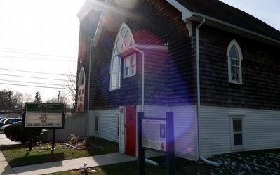
Built as a summer home in 1846 by Stephen Smith (1797?-1873) of Philadelphia. Afro-American businessman, philanthopist, clergyman, and abolitionist, Smith founded Cape May's A.M.E. Church. — — Map (db m206396) HM
On Perry Street just west of North Montgomery Street, on the right when traveling east.
A Bicentennial commemorative site recognizing America’s 200th year of liberty
Mount Zion A.M.E. Church
The Oldest Black Church in Trenton
Incorporated by slaves and freedmen 1811
Original edifice this site 1819
Member Founding . . . — — Map (db m4945) HM
Europeans and Africans moving into the Middle Delaware valley in the late 17th and 18th centuries professed and practiced a variety of religious faiths. In the case of the incoming European settlers, most held to some form of Protestant Christian . . . — — Map (db m239791) HM
Earliest known black church in Madison. The African Union was deeded property 1850, succeeded by First African Methodist Episcopal Church at present site. Rebuilt 1905. — — Map (db m91689) HM
On Spring St. at Bishop Nazery Way, on the right when traveling north on Spring St..
This African-American congregation, first in the county, was incoporated in 1843 by the Bethel Mite Society which raised funds to construct the 1849 carpenter gothic church that stood 150 yards south on the west side of spring street. The present . . . — — Map (db m153558) HM
On S. Yorke Street (County Route 658) 0.2 miles south of E. Broadway (New Jersey Route 49), on the right when traveling south.
has been designated a National Historic Landmark. This site possesses national significance in commemorating the history of the United States of America. Reuben Cuff founded this church in 1800. This present structure was built in 1878.
Rev. . . . — — Map (db m127817) HM
On South Main Street (New Jersey Route 122) 0.1 miles north of Kent Street, on the left when traveling north.
James Campbell (Camel) was born January 16, 1856. He and his wife, Hanna K. Anderson were married on October 9, 1878 and had eight children; four boys and four girls.
James was a "free" born African American who could both read and write. At . . . — — Map (db m157218) HM
On Jerome Avenue north of East 164th Street, on the right when traveling north.
What was here before?
A creek, called Metipathe by the Lenape, once ran through this land into the Harlem River after following a course along what are now River and Jerome Avenues. When European settlers arrived, the creek was sold to John . . . — — Map (db m228714) HM
On Hawley Street east of State Street (Route 434), on the left when traveling west.
Fugitive slaves were aided
on the Underground Railroad
at this site.
Dr. S. Hand house & nearby
A.M.E. Zion and A.M.E. Bethel Church — — Map (db m101993) HM
On Michigan Avenue at Arsenal Place, on the right when traveling north on Michigan Avenue.
The Michigan Avenue Corridor was founded to preserve the roots of freedom and the heritage of Buffalo's East Side. Byron W. Brown, Mayor. City of Buffalo Office of Strategic Planning, Timothy J. Wanamaker, Executive Director. From its earliest . . . — — Map (db m81227) HM
On Mansion Street (New York State Route 385) at Spencer Street, on the right when traveling west on Mansion Street.
This African Methodist Episcopal Congregation was established in 1853 by free &
formerly enslaved people of Coxsackie. Church built 1856. — — Map (db m175175) HM
In January 1863, an historic three-day celebration of the Emancipation Proclamation occurred here at the Bridge Street African Wesleyan Methodist Episcopal Church. On Wednesday night, New Years Eve — known as "watch night" in the church's . . . — — Map (db m242927) HM
On Bridge Street south of Tech Plaza, on the left when traveling south.
Wunsch Hall has been designated a National Historic Landmark.
This site possesses national significance in commemorating the history of the United States of America.
The building dates back to 1847 and was the first independent . . . — — Map (db m242964) HM
On Maple Avenue at School Street, on the right when traveling west on Maple Avenue.
The first African Methodist Church
to be organized in the Village Of Westbury.
Started by a group of former congregants
of the New Light Baptist Church — — Map (db m133530) HM
On Amsterdam Avenue at West 101st Street, on the right when traveling north on Amsterdam Avenue.
This playground is named for Frederick Douglass (1818-1895), celebrated African American abolitionist, orator, author, and statesman. Frederick Douglass Playground is located on Amsterdam Avenue between 100th and 102nd Streets. In 1954, the City . . . — — Map (db m242778) HM
Near West Avenue at Garden Street, on the left when traveling east.
1793 - Born a slave in Prince William County, Virginia
and brought to Sodus and Bath, New York where he self
emancipated by flight.
With the assistance from the Quaker community he
gained legal freedom to become a great abolitionist, . . . — — Map (db m142211) HM
On Union Street just south of 37th Avenue, on the right when traveling south.
The Macedonia African Methodist Episcopal Church is the third oldest religious organization in Flushing. It started out in 1811 as the African Methodist Society, and welcomed a diverse congregation consisting of blacks, whites and Native . . . — — Map (db m193361) HM
On Lippman Plaza just south of 39th Avenue, on the right when traveling south. Reported damaged.
Orange Trail
The Orange Trail takes you through the busiest streets in Flushing, where historic landmarks endure amidst the noise and bustle of the present. You'll encounter some of Flushing "firsts": Flushing High School, the oldest public . . . — — Map (db m193363) HM
On Tompkins Avenue, 0.1 miles south of Tompkins Street, on the right when traveling south.
What was here before?
Stapleton was founded in 1836, and by the 1860s was home to a large German immigrant community who recognized the area's beer brewing potential and its many fresh springs and hillsides for underground cool storage . . . — — Map (db m239474) HM
On Clinton Street at Jefferson Street, on the right when traveling west on Clinton Street.
First African Methodist Episcopal Church in County established here 1846 on land purchased for $100 by black brick workers. Relocated after 1906 landslide. — — Map (db m171790) HM
On Church Street, 0.1 miles south of Vail Street, on the left when traveling south.
Corner stone laid 1908 for church to serve Northport's African American community. Church dissolved 1965. Building later converted to residential use. — — Map (db m147947) HM
On Front Street at Parkers Lane, on the left when traveling west on Front Street.
Welcome to Owego
The Village of Owego affords all the pleasures of small-town life to its visitors and locals alike. Situated on the banks of the picturesque Susquehanna River, Owego has scenic natural views from the Court Street Bridge and . . . — — Map (db m141853) HM
Near Dalton Street, 0.3 miles north of Wyoming Road, on the right when traveling north.
George Avery, a 19-year-old enslaved blacksmith, joined Co. D, 40th United States Colored Troops, in Greeneville, Tennessee, in 1865. According to local tradition, his master, Confederate Maj. William W. McDowell, sent Avery to enlist for a post-war . . . — — Map (db m75527) HM
On West Orange Street north of West Parrish Street, on the right when traveling north.
Since 1898, White Rock Baptist Church, St. Joseph A.M.E. Church, Stanford L. Warren Library, Lincoln Hospital, John Avery Boys and Girls Club, North Carolina College, and Durham Public Schools are all connected historically to black businesses on . . . — — Map (db m210739) HM
On U.S. 1, 0.1 miles north of Main Street, on the left when traveling north.
Resolution passed in 1885 by North Carolina Conference of African Methodist Episcopal Church for establishment of Normal and Industrial School to educate high school students. First session began in 1886. School chartered in 1887 by North Carolina . . . — — Map (db m221999) HM
On West Washington Street, on the right when traveling west.
Front:
In this house, on 11 August 1886, famed African-American educator Booker T. Washington married Olivia A. Davidson. Residents at the time were Mary Davidson Elliott (sister of Olivia) and her husband Dr. Noah Elliott, a veteran of . . . — — Map (db m63680) HM
On Oakes Place, 0.2 miles Flat Rock Road, on the right when traveling south.
This cemetery stands as evidence of a once thriving African American farming community established in the 1820s. With the aid of community leader, Alexander "Sandy" Harper (c.1804-1889), Captina, originally called Guinea, became a stop on the . . . — — Map (db m79263) HM
On U.S. 68 at Lewis B Moore Drive (County Route 55), on the left when traveling north on U.S. 68.
The Underground Railroad in Champaign County
The inhumanity of slavery and the Fugitive Slave Acts of 1793 and 1850 motivated anti-slavery activists to operate a covert network, the "Underground Railroad," which helped fugitive slaves . . . — — Map (db m78141) HM
On Guardian Boulevard east of West 130th Street, on the left when traveling east.
The West Park African American community began in 1809 with the
first black settler and one of the earliest residents of the area, inventor
and farmer George Peake. With the growth of the railroad industry,
African Americans were encouraged to . . . — — Map (db m136899) HM
On Washington Street at Bernard Avenue, on the right when traveling south on Washington Street.
Organized in 1845, Zion African Methodist Episcopal Church is the oldest congregation of African descent in Delaware, with Reverend Daniel Winslow serving as the first minister. In 1853 the cornerstone of the first church was laid, which was . . . — — Map (db m12823) HM
On Long Street at Jefferson Avenue, on the right when traveling east on Long Street.
Organized in 1823 as Bethel African Methodist Episcopal Church, St. Paul A.M.E. Church is the oldest congregation of African descent in Columbus. The church, founded by Moses Freeman and 13 other members from the Town Street Church, was originally . . . — — Map (db m16963) HM
On Pine Street (Ohio Route 160), on the right when traveling north.
Side A:
The African Methodist Episcopal Church was organized in 1818 as the Bethel Church. In 1868 its present name, John Gee, was adopted when the church was erected and rededicated at this present site on land donated by Gee. Founders of . . . — — Map (db m30582) HM
On Brush Row Road at Shorter Avenue, on the left when traveling east on Brush Row Road.
Side A:
In the early 1800s, William and Eleanor Kendall owned this land, known for its natural springs, beauty, and farmland. In 1850, Elias Drake, lawyer and former speaker in the Ohio General Assembly, purchased the property and named it . . . — — Map (db m14058) HM
On Wilberforce-Clifton Road (County Route 94) near Coleman Drive, on the right when traveling north.
Payne Theological Seminary was originally established as Union Seminary in West Jefferson, Ohio, by the Ohio Conference of the African Methodist Church (AME) on October 18, 1844. The Cincinnati Conference of the Methodist Episcopal Church North met . . . — — Map (db m52891) HM
On Bicknell Road, 0.1 miles south of U.S. 42, on the right when traveling south.
Wilberforce University
Wilberforce University, founded at Tawawa Springs in 1856 by the Methodist Episcopal Church, is the first private historically black college or university in America. The inspirations for Wilberforce were an unwavering . . . — — Map (db m52889) HM
A Neighborhood That No Longer Exists
Cincinnati is a city of neighborhoods. One of them is very, very special—because it is no longer there. The Bottoms: a dense urban neighborhood full of churches, full of people. It ran from the River . . . — — Map (db m24995) HM
On Liberty Street, on the left when traveling south.
Side A:
In spite of small numbers and being welcomed by the mostly white congregation of First Methodist Episcopal Church, African Americans in Findlay in the 1880s wanted to express their faith in ways that best reflected their freedoms and . . . — — Map (db m29179) HM
On North Summit Street (Ohio Route 65) at Discovery Way, on the left when traveling north on North Summit Street.
Original Site of Toledo's Oldest Black Institution. In 1847, eight persons formed a mission parish of the African Methodist Episcopal Church (Sandusky Circuit). Reverend Henry J. Young, the minister, had come to Toledo through the Underground . . . — — Map (db m172326) HM
On Edwards Street near Hawthorne Street, on the right when traveling south.
Side A: Oscar D. Boggess Homestead
Oscar D. Boggess (1832-1907) was born in Virginia, the son of a slave and her master. He and his family were granted freedom in the will of his father and master. The will was contested up to the United . . . — — Map (db m43861) HM
On Main Street, on the right when traveling north.
Side A: Piqua's Early African-American Heritage African-American history began in Piqua with the settlement of Arthur Davis in 1818 and expanded with the settlement of the freed Randolph slaves of Virginia in 1846. African-American . . . — — Map (db m17147) HM
On Hoover Avenue at Leland Avenue, on the right when traveling west on Hoover Avenue.
Side A:
The first African American congregation and first African American Methodist Episcopal (AME) Church in Dayton trace their roots back to the early 1830s. They were organized by Father Thomas Willis and a small group of faithful men and . . . — — Map (db m17529) HM
On Paul Laurence Dunbar Street south of Edison Street, on the right.
Born on June 27, 1872 in Dayton to former slaves Joshua and Matilda Dunbar, Paul Laurence Dunbar developed a love of stories during his early years. He wrote his first poem at age six and recited his original Easter Ode at age nine to the . . . — — Map (db m61869) HM
On Muskingum Avenue west of Putnam Avenue (Ohio Route 93), on the right when traveling west.
(Front): A tale of two cities. During the time of the Underground Railroad, Zanesville and Putnam were two communities separated by the Muskingum River with two distinct moral views. The people in Zanesville were proslavery, in Putnam . . . — — Map (db m5624) HM
On Mill Street at Elm Street, on the right when traveling west on Mill Street.
In 1870, African American men in Circleville attempted to vote in municipal elections. Despite the recent ratification of the Fifteenth Amendment, pollsters refused their votes on the basis that state law forbade them from receiving the ballots. The . . . — — Map (db m13641) HM
On North Paint Street near East Main Street (U.S. 50), on the left when traveling north.
The state of Ohio was made possible by the treaty of Paris, 1783, which made the great
lakes the northern boundary of the new United States. In 1787 congress established the
Northwest Territory, dedicated to freedom and public education, with . . . — — Map (db m221650) HM
On Main Street (U.S. 50), on the right when traveling west.
[Marker Front]:
Methodism was known in Chillicothe as early as 1796. During the early years, 1803-1821, both African American and white Methodists worshipped together in a small brick church, located on the north side of Second Street . . . — — Map (db m14665) HM
On West Fourth Street at South Walnut Street, on the left when traveling west on West Fourth Street.
Many heroic men and women joined forces with others in a vast network that helped fugitive slaves secure freedom. Three groups of people were most active in the Underground Railroad movement in Ross County. They were the Presbyterians, the Quakers . . . — — Map (db m118737) HM
On Main Street (U.S. 77) at 8th Street, on the right when traveling north on Main Street.
From the beginning, African-Americans settled and lived in Newkirk -- although this was not true in most of the towns in Kay County. They settled primarily on the east side of town, building their own community which included churches, . . . — — Map (db m60443) HM
On North Greenwood Avenue north of East Cameron Street, on the right when traveling north.
Placed on
National Register of Historic Places
This historic African Methodist Episcopal Church, founded in 1905 and is the only standing structure (basement) left of the Historic Black Wall Street. It is the only edifice remaining form . . . — — Map (db m171407) HM
On North Washington Street, 0.1 miles south of West Stevens Street.
Born a free African-American. He taught the Colored people at this college, 1837, while a student at the Lutheran Seminary. A historian, he was elected bishop of the A.M.E. Church, 1852, and was president of Wilberforce University, 1863-76. — — Map (db m40951) HM
On Seminary Ridge Avenue, 0.2 miles south of Buford Avenue (U.S. 30), on the left when traveling south.
Daniel A. Payne was born a free person of color in Charleston, South Carolina and came to Gettysburg Seminary in 1835 to study theology after a law prohibiting the education of slaves forced him to close his school and abandon teaching. With his . . . — — Map (db m66679) HM
On W High Street at S Franklin Street, on the right when traveling west on W High Street.
On this corner stood the only building built for the sole purpose of educating the Colored children of the Borough of Gettysburg. In 1834 Pennsylvania mandated public education. On September 19, 1934, citizens of Gettysburg met and chose six . . . — — Map (db m75467) HM
On First Avenue at Smithfield Street, on the right when traveling west on First Avenue.
Founded 1808 & known as the African Church. Chartered in 1818. Located nearby in early years, church was site of area's first school for colored children, 1831, and statewide civil rights convention, 1841. Congregation moved to Wylie Avenue, 1872; . . . — — Map (db m42023) HM
On Mulberry Street at Fulton Street on Mulberry Street.
The church was founded in 1830 by former slaves and was first black organization in Beaver County Built on Mulberry Street in 1880. Destroyed by fire in 1900 and rebuilt in 1902. It was damaged severely by the 1936 flood. The present church was . . . — — Map (db m45794) HM
Founded in 1837 as an outgrowth of St. John A.M.E. Bridgewater
First church of denomination between Pittsburgh and Cleveland
Original building built on 3rd Ave. Used until 1878. Chartered in 1880. Current church building erected in 1894. — — Map (db m98012) HM
On N. 10th Street at Hinnershitz Street, on the left when traveling south on N. 10th Street.
Berks County's oldest Black church building. Erected 1837 by free African Americans; became an Underground Railroad station for escaped slaves seeking freedom. Rebuilt 1867; remodeled 1889. Congregation, dating from 1822, moved to Windsor Street in . . . — — Map (db m25205) HM
On North Fairfield Road just south of Berwyn Baptist Road, on the right when traveling south.
In 1932, Tredyffrin and Easttown school districts began segregating their elementary schools. Local Black families and supporters met at Mt. Zion A.M.E. Church and planned to fight this discrimination. The resulting boycott deprived affected . . . — — Map (db m205616) HM
On Modena Road at South 1st Avenue, on the right when traveling north on Modena Road.
In 1938, a young black man was accused of raping a white girl. With the threat of a second lynching at stake, the black community rebuffed the allegations as they marched to the city jail with weapons in hand to ensure justice.
Thereafter, . . . — — Map (db m205653) HM
On Pomfret Street, on the left when traveling east.
Among the earliest (c.1820) African American congregations located west of the Susquehanna River. The site of Underground Railroad activity. Abolitionists John Peck and John B. Vashon were members. A.M.E. national Bishops Daniel Payne and Wills . . . — — Map (db m40952) HM
Memorial Park, created in 1974 as a recreation area for the surrounding community, stands on the site of Lincoln Cemetery. Originally named the African Cemetery of Carlisle, Lincoln Cemetery was in use as early as 1806.
Several hundred . . . — — Map (db m53631) HM
On Forster Street north of North Street, on the right when traveling north.
Bethel During the World Wars
When the Commonwealth purchased the State Street Church to extend the Capitol Complex, church leaders—Mr. C. Sylvester Jackson and his wife—purchased a lot on Briggs Street at Ash Avenue for a new sanctuary. . . . — — Map (db m134672) HM
By 1873, Bethel AME Church served three elements of the city’s Black population; those free before the Civil War, those emancipated and placed in Bethel’s care by the Freedman’s Bureau; and immigrants fleeing the South’s Jim Crow laws.
To shelter . . . — — Map (db m85932) HM
The second Bethel AME Church opened on Short Street on November 24, 1839. Bethel’s first pastors-Reverend Levin Lee (ca. 1833-1843), Reverend T.M.D. Ward (1843-1845), and Reverend Abraham Cole (1846-ca.1854) --- each helped increase interest in the . . . — — Map (db m85917) HM
On North 6th Street at Herr Street, on the left when traveling north on North 6th Street.
Because of the second State Capitol extension, Bethel AME Church purchased the Ridge Avenue Methodist Church building in 1953. (Sixth Street was formerly named Ridge Avenue). The Colored Wesleyan Burial Ground was located on Herr Street about fifty . . . — — Map (db m134669) HM
On East 12th Street (Pennsylvania Route 5/290) at Holland Street, on the right when traveling west on East 12th Street.
At 236 East 11th Street. Founded 1874, this is Erie's oldest African-American congregation. Five of its first six members were women. Originally at 3rd and German Streets, this church has long ministered to the spiritual and social needs of the Erie . . . — — Map (db m41044) HM
On North 5th Street south of Cedar Terrace, on the right when traveling north.
As early as 1857 there was some form of public school being offered to the children of color in Colombia - 43 males and 47 females were enrolled in classes that year
In 1872, Zion Hill AME Church turned over the property located on the south . . . — — Map (db m241495) HM
On South Queen Street (Pennsylvania Route 72) south of West Vine Street, on the left when traveling north.
At the root of Lancaster City's history, one major element is consistent...diversity. In the mid 1700s, the first citizens were from a variety of ethnic and religious backgrounds — German, Scots-Irish, and English.
❖ German . . . — — Map (db m136450) HM
Essayist, teacher, and author, her work, The Curse of Caste, is considered to be among the first published novels by an African American woman. In 1865, it was serialized in the African Methodist Episcopal Christian Recorder, a . . . — — Map (db m74272) HM
On 3rd Street north of Fulmer Avenue / Kraemer Avenue, on the left when traveling north.
In 1868 the "Little Bethel" AME Church was built as a permanent place of worship for free yet segregated Native and Black Americans. Here they worshiped "Almighty God." The diverse congregation included Monroe County's Veterans of the United . . . — — Map (db m217042) HM WM
On Germantown Avenue at West Stella Street, on the left when traveling north on Germantown Avenue.
The Underground Rail Road
In the years before the Civil War, there was a route that slaves could take to freedom. It came to be called the "Underground Rail Road" a secret network of safe houses or "stations" operated by "station masters", . . . — — Map (db m220470) HM
Near North 16th Street north of West Courtland Street, on the right when traveling south.
"This land which we have watered with our tears and our blood is now our Mother Country and we are well satisfied to stay where wisdom abounds and the Gospel is free."
- Richard Allen, free slave who established the first African . . . — — Map (db m232106) HM
On North 4th Street at North Marginal Road, on the left when traveling south on North 4th Street.
Old St. George's
In 1729, in Oxford, England, a group of fiery, compelling preachers began the religious movement that would become Methodism. Preaching a message of repentance and conversion, men like Captain Thomas Webb and Francis Asbury led . . . — — Map (db m135998) HM
Purchased in 1810 by Mother Bethel A.M.E. Church trustees, it was among the first independent cemeteries for the free Black community. Burials ceased in 1864. The land was sold to the city in 1889. Weccacoe Park was built over the graves of . . . — — Map (db m146545) HM
On South 6th Street, on the left when traveling south.
Established in 1787 under the leadership of Richard Allen and Absalom Jones, this organization fostered identity, leadership, and unity among Blacks and became the forerunner of the first African-American churches in this city. — — Map (db m189077) HM
On South 6th Street at Lombard Street, on the right when traveling north on South 6th Street.
On Wednesday, June 17, 2015, the pastor and eight faithful members were tragically slain in a mass shooting at
Emanuel African Methodist Episcopal Church
Charleston, South Carolina
They had come together with great joy for a weekly . . . — — Map (db m220513) HM
On South 6th Street at Addison Street, on the left when traveling south on South 6th Street.
Mother Bethel is the first African Methodist Episcopal (A.M.E.) Church in America, founded in 1791. Richard Allen (1760-1831), a former slave, was the founder, and later became the first bishop (1816) of the first African-American denomination in . . . — — Map (db m6840) HM
Founded on ground purchased by Richard Allen in 1791, this congregation is the mother church of the African Methodist denomination. The present structure, erected in 1889, replaces three earlier churches on this site. — — Map (db m81660) HM
On Addison Street at Addison Street, on the right when traveling north on Addison Street.
Mother Bethel
(Founded by Richard Allen)
African Methodist Episcopal Church
has occupied this site continuously since its founding and in its earliest years enjoyed the active financial and moral support of Dr. Benjamin Rush
Signer of . . . — — Map (db m220501) HM
On South 6th Street north of Lombard Street, on the right when traveling north.
Mother Bethel
African Methodist Episcopal Church
founded on this site 1787
by
Richard Allen
(a former slave)
This ground, purchased by Richard Allen for a church, is the oldest parcel of real estate owned . . . — — Map (db m220504) HM
On Pine Street east of Lawrence Court, on the right when traveling east.
Old Pine Street (side 1)
This congregation was organized as the Third Presbyterian Church in Philadelphia in 1768. The original building, completed that same year, was a simple Georgian structure of red brick, designed by Robert Smith, . . . — — Map (db m135995) HM
On South 6th Street at Lombard Street, on the right when traveling north on South 6th Street.
Founder and first Bishop
of the
African Methodist Episcopal Church
Apostle of freedom proclaiming a liberating and reconciling Gospel
Bishops of the AME Church
John Richard Bryant •
McKinley Young •
William Phillips Deveaux, . . . — — Map (db m220509) HM
On Lombard Street at South 6th Street, on the right when traveling west on Lombard Street.
In 1946, a journey began to erect a fitting monument to Bishop Richard Allen, the founder of the African Methodist Episcopal Church. That year, the Richard Allen Statue Committee was organized to petition the Philadelphia Park Commission for a . . . — — Map (db m220511) HM
Here in 1836 a church related company began printing hymnals, religious materials, and works by Black authors of the period. In 1847 The Christian Recorder was published here. Bishop Benjamin Tucker Tanner was editor of the firm until 1884. — — Map (db m83447) HM
On Market Street at South Independence Mall West (6th Street), on the right when traveling east on Market Street.
Stolen
Some people trace their roots back many generations with letters, a family Bible that records events, and stories that connect them to the past or identify the place from which their family came.
The descendants of enslaved Africans . . . — — Map (db m102443) HM
Near Arch Street west of North 5th Street (Pennsylvania Route 2003), on the left when traveling east.
James Oronoke Dexter, an important member of Philadelphia's free African-American community, lived on this block. Dexter, a coachman, was an early member of the Free African Society. When members of this group went on to found the African . . . — — Map (db m227607) HM
On Arch Street just west of North 5th Street (County Road 2003), on the left when traveling east.
We, the free Africans and their descendants, of the City of Philadelphia, in the State of Pennsylvania, or elsewhere, do unanimously agree, for the benefit of each other, to advance one shilling…a month…to hand forth to the needy of . . . — — Map (db m227606) HM
Near Meeting Street just west of Thayer Street, on the left.
Former site of the Bethel A.M.E. Church 1866-1961
Beginning as a free mission in 1795, members met in the African Meeting House before purchasing this lot in 1820. The services were held in the homes of the members for over 40 years. In 1866, . . . — — Map (db m30314) HM
On Henry M. Turner Street at Secession Avenue, on the left when traveling south on Henry M. Turner Street.
Historical Bicentennial marker
in memory of
Henry McNeal Turner
1834-1915
Birthplace: Newberry, South Carolina - Boyhood home: Abbeville, South Carolina
Missionary Pioneer to South Africa, Liberation Theologian, Social and Political . . . — — Map (db m20249) HM
On Calhoun Street, on the left when traveling south.
The Methodist Society, organized in Bluffton,
built the first church and parsonage on
Boundry Street in 1853. During the Civil War,
two confederate soldiers saved the
church from being burned. In 1875 the church
sold the building to the . . . — — Map (db m39840) HM
On Boundary Street north of Maiden Lane, on the right when traveling north.
Built in 1853, this was originally Bluffton Methodist Episcopal church. Organized by whites, the church's 216 members in 1861 included 181 African Americas, who were likely enslaved to its white congregants. The church caught fire during the . . . — — Map (db m218551) HM
On Beach City Rd, 0.7 miles Dillon Rd, on the right.
Early A.M.E. Missionaries to South Carolina, Rev. James H.A. Johnson and Rev. James A. Handy, arrived at Hilton Head on the Steamship Arago at 3:18 p.m. Friday, May 12, 1865.
Rev. James Lynch, also an A.M.E. Missionary, shared entertainment . . . — — Map (db m104498) HM