Near Victoria Avenue at Cornwall Street, on the right when traveling west.
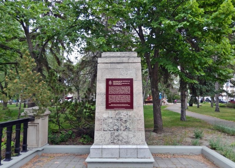
[English] The province of Saskatchewan, formerly of the North West Territories, was created on 1 September, 1905, and inaugurated on this site by Governor General Earl Grey and Prime Minister Sir Wilfred Laurier on 4 September, . . . — — Map (db m201271) HM
Near Victoria Avenue at Cornwall Street, on the right when traveling west.
Walter Scott, a prominent journalist and politician, was raised in rural Ontario. In 1885 he moved west and, as a member of Parliament (1900-1905), played a leading role in achieving provincial status for Saskatchewan. Appointed its first Premier . . . — — Map (db m215979) HM
On Broadway Avenue North at Burrows Avenue West, on the right when traveling south on Broadway Avenue North.
This water tower was purchased from the Prince Albert Penitentiary in 1927 & moved here the following year. The light on top of the tower was put into service in April 1929. Sometime later the frost-free casing was built. The tower was in use until . . . — — Map (db m196891) HM
On Redcoat Trail (National Highway 2) at Surdia Rd, on the right when traveling south on Redcoat Trail.
The Saskatchewan Air Ambulance service, born under the reign of T.C. (Tommy) Douglas, Premier of Saskatchewan made its' first flight February 3, 1946. The crews faced the extremes of Saskatchewan weather, often flying in near impossible conditions . . . — — Map (db m205049) HM
On dirt farm lane, on the right when traveling south.
This cairn marks the site of the village of Ettington and where for 20 years McGuire’s Store was the heart of the community. Formed in 1913 with the arrival of the C.N. rail line, Ettington at one time had a population of 130 people. The community . . . — — Map (db m205018) HM
On Lorne Street West at 2nd Avenue NW, on the right when traveling west on Lorne Street West.
The Court House is one of the best historical landmarks in Swift Current. Designed by Raymond Philbrick, its construction began in 1913 and was completed in 1916. It was the first provincial building constructed outside of Regina dedicated to serve . . . — — Map (db m196930) HM
On 3 Avenue Northeast just north of Chaplin Street East, on the right when traveling north.
Dedicated in 1913, this church’s architecture reveals a gothic influence. The structure began as the home of the Knox Presbyterian Church. After the Metropolitan Methodist Church burned down in 1946, the Knox Presbyterians and the Metropolitan . . . — — Map (db m202461) HM
On Snowbird Highway (National Highway 2), on the left when traveling south.
An Indian legend from the 1800s reveals how Old Wives Lake, to the west, was named. One winter a Cree party went beyond their traditional area in search of buffalo. They ventured into territory claimed by both the Cree and Blackfoot.
The Cree . . . — — Map (db m204855) HM
On Railway Avenue, 0.1 kilometers north of 1 Street South, on the right when traveling north.
In memory of all those of Canada’s Armed Forces who gave their lives in the conflicts of W.W. I 1914-1918 W.W. II 1939-1945 Korea — — Map (db m211883) WM
On Provincial Highway 26, 0.1 kilometers north of Railway Avenue East, on the right when traveling north.
This windmill was erected by the people of Edam and District to celebrate the 75th anniversary of the Province of Saskatchewan and to honour the original Dutch settlers, some from Edam, Holland who homesteaded in this area during the period 1904 – . . . — — Map (db m211875) HM
Near Trans-Canada Highway (Provincial Highway 1) 10 kilometers west of Allowance Road West (Provincial Road 632), on the left when traveling west.
Named for the herds of Pronghorn Antelope that roamed the prairies. 1900-1906 it was situated north of the C.P.R. track and listed as a siding 538 miles west of Winnipeg in the Northwest Territories. A town site almost directly south of here was . . . — — Map (db m201114) HM
Near Trans-Canada Highway (Provincial Highway 1) 10 kilometers west of Allowance Road West (Provincial Road 632), on the left when traveling west.
The school district was formed June 17, 1918. The school was built in 1919 on Sec. 1-14-18 W3 just to the south of the Hamlet of Antelope. Opening January 26, 1920 and in operation continuously until June 30, 1963. At one time 42 students, grades . . . — — Map (db m201115) HM
Near Trans-Canada Highway (National Highway 1) 6 kilometers east of Provincial Highway 37, on the right when traveling east.
This trail approximated the route of the C.P.R., and after 1883 was an important patrol route of the N.W.M.P. linking Divisional Headquarters at Maple Creek and the Swift Current Detachment. Used by pioneer ranchers and homesteaders well into the . . . — — Map (db m201262) HM
On Bosworth Street at Atlantic Avenue, on the right when traveling west on Bosworth Street.
This Municipal Heritage Building was a prefabricated wood-frame structure assembled for the Bank of Commerce in 1910. It exhibits the Georgian Classical style typical of smaller banks of the period and was one of the first businesses established in . . . — — Map (db m196901) HM
On Manitoba Avenue at Lanigan Street, on the right when traveling south on Manitoba Avenue.
This Municipal Heritage Building of brick and Manitoba Tyndall Stone, designed by provincial architect, Maurice Sharon, was completed in 1920.
Kerrobert was the seat of the judicial circuit from 1913 to 1996. The courthouse held offices of . . . — — Map (db m196900) HM
On Prairie Avenue at 3rd Street Northeast, on the right when traveling west on Prairie Avenue.
Weyburn Court House was designed by Provincial Architect Maurice Sharon in a distinctive Colonial style. Constructed in 1928, this elegant building expressed the confident aspirations of Saskatchewan towns in the last good harvest year before the . . . — — Map (db m203784) HM
On Second Avenue just east of Dean Street, on the right when traveling east.
The Mortlach Fire Hall and the bell played an important part in the early days of Mortlach's settlement and development. The Fire Hall was built in 1911.
The lower hall housed the horse drawn water tank and hose, which along with volunteers was . . . — — Map (db m196922) HM
On Trans-Canada Highway (Provincial Highway 1) 4.5 kilometers east of Highway 626, on the right when traveling west.
This marker at the Third Meridian, which is a major control survey line upon which the survey of Saskatchewan’s lands to the west depends, honors the work of pioneer surveyors who overcame great difficulties in establishing a vast survey system on . . . — — Map (db m202460) HM
On un-named, un-numbered dirt road, on the right when traveling south.
(top plaque)
Gondney School District 3781 br>
Established in June 1916. This school district was named from Goudney, Manitoba. The 'u' being mistaken for 'n'. The school, contracted by Waterman-Waterbury, was built in 1917 one mile . . . — — Map (db m205154) HM
On Edouard Beaupre Street at Avenue B (Provincial Highway 36), on the right when traveling east on Edouard Beaupre Street.
Born on January 9, 1881 at Willow Bunch (Talles Des Saules). Edouard was the eldest son of Gaspard Beaupre and Florentine Piche, Willow Bunch pioneers.
He died of lung hemorrhage, caused by tuberculosis while working for Ringling Brothers at . . . — — Map (db m205162) HM
On Edouard Beaupre Street at D Avenue, on the right when traveling east on Edouard Beaupre Street.
Trader and pioneer settler of Willow Bunch, where he opened a post in 1880, Jean-Louis Légaré, a native of Québec, had entered the fur trader at Wood Mountain in 1870. He became the trusted friend and unofficial spokesman for the . . . — — Map (db m205198) HM
On Lalonde Street at 1st Avenue, on the right when traveling south on Lalonde Street.
This park dedicated by the Town of Whitewood to Mayor Fred J. Hack, founder, in appreciation of his outstanding contributions to the community. July 15, 1973. — — Map (db m209039) HM
On Main Street at Service Street, on the right when traveling south on Main Street.
You can imagine the flurry of activity that occurred upon the arrival of the Barr Colonists. The few pioneers that were here finally had lots of neighbors, green though they were to this life on the prairies. The Mission Hall (1903) was moved in . . . — — Map (db m212376) HM
On Main Street at Service Street, on the right when traveling south on Main Street.
March 31, 1903: two thousand British Immigrants departed Liverpool, England; caught up with Reverend Isaac Barr's vision of founding a British Colony in Canada's North West Territories, with a prize of 160 acres of land for $10.00 and homestead . . . — — Map (db m212375) HM
On Main Street at Service Street, on the right when traveling south on Main Street.
In 1907, the Canadian Northern Railway Station plus a coal dock and water tank were followed by implement dealerships, a butcher shop, restaurants, bakery and a drug store. The Lashburn Public School opened. A second doctor and an undertaker came . . . — — Map (db m212377) HM
On Varennes Street just west of Richmond Street, on the right when traveling west.
In early twentieth century Saskatchewan, optimism was a chief driving force for many communities. Reflecting the view that growth was inevitable, many towns and cities built elaborate Town Hall-Opera House structures. Wolseley commissioned Manitoba . . . — — Map (db m200632) HM
127 entries matched your criteria. Entries 101 through 127 are listed above. ⊲ Previous 100