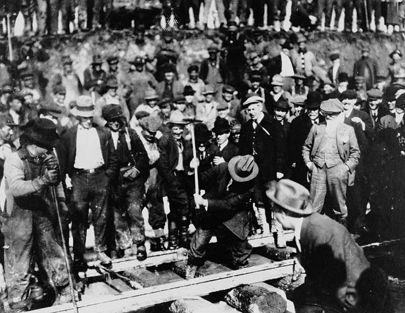
The last spike in Canada's second trans-continental railroad was driven near this site on April 7, 1914. The Grand Trunk Pacific became the most important factor in the dvelopment of Central British Columbia. However, financial problems plagued the . . . — — Map (db m187999) HM
[English] This hotel was built between 1904 and 1908, and has since been enlarged twice. The architect, Francis M. Rattenbury, followed the practice of the Canadian Pacific Railway in employing the Chateau style, identifiable by the steep slate . . . — — Map (db m49238) HM
Built for coal magnate Robert Dunsmuir, Craigdarroch symbolized the desire of late 19th-century industrialists to assert their social position through conspicuous displays of wealth. Completed in 1890, the eclectic mansion features . . . — — Map (db m72876) HM
This imposing brick roundhouse is a particularly fine example of an industrial structure associated with the steam railway era in Canada. Built in 1913, the ten-stall roundhouse with attached machine, boiler and blacksmith's shops is part of a . . . — — Map (db m72877) HM
Plans to complete the Pacific Great Eastern Railroad to Prince George in 1921 failed because instable ground prevented use of the proposed bridge site on the Cottonwood River. Thus construction stopped at Quesnel. As northern expansion continued, . . . — — Map (db m188026) HM
In the the early 1860s placer gold drew prospectors from all parts of the West to the Salmo River valley, and the Dewdney Trail from the west coast soon opened the region to increased travel. Development increased dramatically in 1893, when Daniel . . . — — Map (db m187931) HM
[English] While exploring these mountains in the summer of 1865, Walter Moberly, assistant surveyor-general of British Columbia, noted the flight of eagles through a break in the Gold Range (Monashees), thereby discovering Eagle Pass. After . . . — — Map (db m198549) HM
A nebulous dream was a reality: an iron ribbon crossed Canada from sea to sea. Often following the footsteps of early explorers, nearly 3000 miles of steel rail pushed across vast prairies, cleft lofty mountain passes, twisted through canyons, and . . . — — Map (db m187955) HM
[English]
Baldwin #7717 Steam Locomotive
This Baldwin 2-6-0 mogul steam engine – builders #7717 – road #6 – 36" gauge locomotive, was built for the North Western Coal & Navigation Co. in 1885. It was originally used . . . — — Map (db m44339) HM
First recorded in the report of the Palliser expedition of 1857-60, this pass takes its name from an incident in which Dr. James Hector, surgeon in the expedition, was kicked by his horse while exploring in this vicinity. The pass was virtually . . . — — Map (db m74545) HM
[English] Take a look across the river. A century ago, an elegant hotel dominated this view. Now just a memory, Mount Stephen House was the first in a series of “Grand Hotels” built by the Canadian Pacific Railway. The CPR . . . — — Map (db m203580) HM
[English] In 1901, Mount Stephen Reserve was enlarged and became Yoho Park Reserve. The following year, Mount Stephen House was also expanded and now featured a rotunda, a huge dining room, a theatre and 60 rooms. Word got out . . . — — Map (db m203581) HM
[English] It was not my intention to have passed any great time at Field, yet I was detained there by the force of its attraction… the views from Field are fine and the excursions that can be made in the neighbourhood are . . . — — Map (db m203582) HM
Naming the Kicking Horse In the mid-1850s, an expedition was sent out by the Imperial Government to locate a feasible route west through the Canadian Rockies that would give good access to settlers in search of rich farming soil and . . . — — Map (db m203579) HM
A ninety room hotel complete with bowling alley and observation tower once stood in this quiet clearing!Operated by the Canadian Pacific Railway from 1887 to 1925, it was used as a base by mountaineers, adventurers and sightseers from all over the . . . — — Map (db m108665) HM
For many years steam locomotives on the mainline of the Canadian Pacific Railway rumbled across these stone pillars.
Construction of the railway through these rugged mountains was a constant struggle. In this area, steep-sided valleys and . . . — — Map (db m110556) HM
The Canadian Pacific Railway helped open up south-east British Columbia with a strategic line through the Rocky Mountain Crowsnest Pass. It also helped maintain Canadian sovereignty over Kootenay mineral wealth which had been flowing south to . . . — — Map (db m187918) HM
In 1893 a Kootenay Indian, Pierre,
found a rich galena outcrop in
the hills nearby. Father Coccola
of St. Eugene Mission arranged
sale of the claims, and with the
proceeds built a new home for
Pierre and a new mission church.
Development of . . . — — Map (db m187928) HM
On Nov. 21, 1950, a westbound
train carrying Canadian troops
en route to the Korean War
collided with an eastbound train
near Canoe River, killing 21
people. A telegraph operator
was charged with manslaughter
for the miscommunication and
was . . . — — Map (db m187887) HM
Named after “Tete Jaune”, blond fur trader at Jasper House, this low pass was favoured by Sandford Fleming in his railway surveys of the 1870's. Rejected by the C.P.R., the route was later used by the Grand Trunk Pacific and the Canadian Northern . . . — — Map (db m187943) HM
[English] This pass was used for brief periods from the mid-1820s to the early 1850s by the Hudson's Bay Company, principally to transport leather, especially moosehides, from the Saskatchewan District to its posts in New Caledonia. . . . — — Map (db m202600) HM
The Pacific Great Eastern Railway Station was built to service a rail link between North Vancouver westward along Howe Sound to the interior of the province. The foot of Lonsdale became a busy transportation hub in the early days of the community as . . . — — Map (db m31979) HM
Here stood
Hamilton
First Land Commissioner
Canadian Pacific Railway
1885
in the silent solitude
of the primeval forest
He drove a wooden stake
in the earth and commenced
to measure an empty land
into the streets of . . . — — Map (db m40645) HM
Cascade came into being during the late-1890s as a bustling railway construction town claiming 17 hotels at its height. Its location along the Canada-U.S. border proved strategic for mining, freighting, and hydro-electricity. The early development . . . — — Map (db m187915) HM
In 1900, the CPR's Columbia & Western Railway penetrated the formidable mountains between Nelson and Midway, connecting the Boundary district to East Kootenay coalfields and beyond. Eholt, at the summit between Grand Forks and Greenwood, became the . . . — — Map (db m187908) HM
When the Midway to Hope section of the “K.V.” was completed in 1916 and joined with existing short lines, it formed a direct southern railroad from Alberta to the Pacific Coast. An important factor in advancing the economy of southern B.C., it has . . . — — Map (db m187941) HM
Proximity to Boundary Creek mines, and excellent climate, water and soil convinced Midway promoters of a bright future as a "railway and residential town.” The Columbia & Western Railway reached Midway in 1900; five years later, the Vancouver, . . . — — Map (db m187938) HM
Colonel R.C. Moody, R.E., recognized the potential value of Burrard Inlet for military defence. Named in his honour, Port Moody became the western terminus of the Canadian Pacific Railway. Although a branch line was built in 1887 to the growing city . . . — — Map (db m187971) HM
Canada Pacific Railway Station
Architects: Barott, Blackader & Webster
As the terminus for the Canadian Pacific Railway, this site has been an important landmark since the completion of the railway in 1886. This Neo-Classical . . . — — Map (db m236312) HM
Canada Place was the Canadian Pacific Railway's Pier B-C ocean liner terminal in the 1920s. In 1982, the Government of Canada redeveloped it as the Canadian Pavilion for The Expo '86 World Fair and dedicated it as a legacy for the Canadian people. . . . — — Map (db m236308) HM
Erected between 1917-1919, this station was built as the western terminus for the Canadian Northern Railway. It is an excellent example of Neoclassical Revival Style design which was popular for train stations. The monumental central archway with an . . . — — Map (db m235881) HM
This old covered bridge and parts of the abandoned right-of-way are mute reminders of the Vancouver, Victoria und Eastern Railway (VVAE), a subsidiary of the American-based Great Northern Railway. Between 1907 and 1914, the VVAE pushed northward, . . . — — Map (db m187920) HM
Canada's third trans-continental rail link was completed near Basque on January 23, 1915. In a simple ceremony the last spike was driven, witnessed by a small group of engineers and workmen. The line later became part of the Federal Government's . . . — — Map (db m187813) HM
Smooth rivers and great lakes once were the highways of travel. On them plied stately paddle-wheelers, helping exploration and settlement of the Interior. They speeded gold-seekers bound for the “Big Bend” rush of 1864-65. They freighted grain from . . . — — Map (db m187961) HM
Bill Miner, notorious American stagecoach and train robber, stole $7,000 in British Columbia's first train holdup, near Mission in 1904. For two years, unsuspected, he lived quietly near Princeton, well-liked by all. In 1906 he stopped the wrong . . . — — Map (db m187878) HM
Founded in 1812, Fort Kamloops stood at a natural crossroads. For 50 years it remained the focus of an inland fur empire until the roaring mining boom of the 1860's. Ranchers, with cattle and horses, replaced the miners. They settled, and stayed, to . . . — — Map (db m188009) HM