By Mark Hilton, November 16, 2016
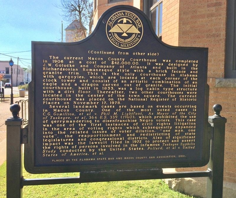
Macon County Legal Milestone Marker (Reverse)
GEOGRAPHIC SORT WITH USA FIRST Geographic Sort Title Sort Marker Number Sort Marker Number Sort N Marker Number Sort T Publication Order Sort Publication Order Sort A Erected Year Sort Most Viewed Sort Most Recent-Interest Sort Most Recently Changed Sort SEE FAQ #33 FOR DESCRIPTIONS
On East Rosa Parks Avenue at Eastside Street, on the left when traveling east on East Rosa Parks Avenue.
On West Montgomery Road east of Chambliss Street, on the right when traveling east.
Near Chief Anderson Road.
Near University Avenue, 0.2 miles east of Booker T. Washington Boulevard.
On University Avenue at Lewis Adams Street, on the right when traveling east on University Avenue.
On Booker T Washington Boulevard at Campus Drive, on the right when traveling north on Booker T Washington Boulevard.
Near University Avenue, 0.2 miles east of Booker T. Washington Boulevard.
On University Avenue, 0.2 miles east of Booker T. Washington Boulevard, on the right when traveling east.
On University Avenue west of Tuskegee Airmen Circle, on the right when traveling west.
On University Avenue at Lewis Adams Street, on the right when traveling west on University Avenue.
On University Avenue west of Lewis Adams Street, on the right when traveling east.
On University Avenue at Tuskegee Airmen Circle, on the right when traveling east on University Avenue.
On John T Reid Parkway/Lee Highway (U.S. 72) 0.1 miles east of Walker Street, on the right when traveling west.
Near Ford's Chapel Drive at Autumn Drive, on the right when traveling north.
Paid Advertisement
On Franklin Street Southeast at Gates Avenue Southeast, on the right when traveling south on Franklin Street Southeast.
On Holmes Avenue close to Lincoln St., NE.
On Church Street, NW. Reported missing.
On Echols Street near Adams Street, on the right when traveling west.
On Williams Avenue SE east of Franklin Street SE.
On Randolph Avenue Southeast, 0.1 miles east of Lincoln Street SE, on the right when traveling east.
On Metaire Lane north of Eastview Drive, on the left when traveling north.
On Cahaba Avenue (Alabama Route 28) at North Mobile Street, on the left when traveling west on Cahaba Avenue.
On Military Street South (U.S. 278) at 1st Avenue SW, on the right when traveling south on Military Street South.
On Bankhead Highway, on the right when traveling east.
Near Cathedral Caverns Highway north of 1st Street West, on the left when traveling north.
On Blount Avenue, 0.1 miles north of Taylor Street, on the right when traveling north.
Near U.S. 43 south of Lucas Road, on the right when traveling south.
On Government Street (U.S. 90) at South Franklin Street, on the right when traveling west on Government Street.
On St Francis Street, 0.1 miles west of North Lawrence Street, on the right when traveling west.
On North Broad Street at Congress Street, on the right when traveling south on North Broad Street.
Paid Advertisement
On St. Anthony Street at North Hamilton Street, on the right when traveling west on St. Anthony Street.
On South Royal Street south of Government Street, on the left when traveling south.
On North Dearborn Street at St Francis Street, on the right when traveling south on North Dearborn Street.
On Government Street (U.S. 90) at South Bayou Street, on the right when traveling west on Government Street.
On St Louis Street at North Water Street, on the right when traveling east on St Louis Street.
On St Francis Street at St Joseph Street, in the median on St Francis Street.
On Martin Luther King Jr. Avenue west of North Lawrence Street, on the right when traveling west.
On South Joachim Street, 0.1 miles south of Dauphin Street, on the left when traveling south.
On Dauphin Street, 0.1 miles east of Common Street, on the right when traveling east.
On South Joachim Street, 0.1 miles south of Dauphin Street, on the right.
On Springhill Avenue east of Silverwood Street, on the right when traveling east.
On Springhill Avenue, 0.3 miles west of Mobile Infirmary Boulevard, on the right when traveling west.
On Government Street (U.S. 90) at South Scott Street, on the right when traveling east on Government Street.
On St Anthony Street at North Bayou Street, on the right when traveling west on St Anthony Street.
On Michigan Avenue at Eagle Drive, on the right when traveling south on Michigan Avenue.
On North Alabama Avenue, on the left when traveling north.
Paid Advertisement
Near North Bainbridge Street at Dexter Avenue, on the right when traveling north.
On Early Street at Rosa L Parks Avenue, on the right when traveling west on Early Street.
On Washington Avenue at South Perry Street, on the right when traveling west on Washington Avenue.
On South Perry Street, 0.1 miles north of Grove Street, on the left when traveling north.
On Dexter Avenue east of Court Square, on the left when traveling east.
On North Hull Street at East Jefferson Street, on the right when traveling north on North Hull Street.
On South Jackson Street at Tuscaloosa St. on South Jackson Street.
On North Hull Street at East Jefferson Street, on the right when traveling north on North Hull Street.
Near South Court Street at High Street. Reported missing.
On Washington Avenue at South Hull Street, on the left when traveling west on Washington Avenue.
On Felder Avenue west of Dunbar Street, on the right when traveling west.
Near Madison Avenue (Alabama Route 108) at North Hull Street, on the right when traveling west.
On South Decatur Street (Alabama Route 21) at Scott Street on South Decatur Street.
On South Perry Street, on the left when traveling north.
On Norman Bridge Road at Park Avenue, on the right when traveling north on Norman Bridge Road.
Paid Advertisement
On Vine Street Northwest at Grove Street Northwest, on the left when traveling north on Vine Street Northwest.
On Nat Key Road, 0.6 miles south of Gibson Road, on the left when traveling south.
On Polk Street south of College Street, on the right when traveling south.
On 2nd Street Northwest (Church Street) south of 2nd Avenue Northwest, on the left when traveling south.
On County Road 2203 south of County Road 2204, on the left when traveling south.
On McKinley Drive north of University Avenue, on the left when traveling north.
On University Avenue, on the right.
On University Avenue west of Luther Drive, on the left when traveling west.
Near University Avenue, on the right.
On University Avenue, on the right.
On University Avenue, on the right.
On East Walnut Street at North Market Street, on the right when traveling west on East Walnut Street.
On Airport Road, 0.1 miles west of Sikorsky Road, on the right when traveling west.
On County Road 79 near 667.
Paid Advertisement
On U.S. 80 at Bleeker Road, on the right when traveling east on U.S. 80.
Near Highland Street near Bloch Street.
On Greensport Road (County Route 24), on the left when traveling east.
On North Broadway Avenue (Alabama Route 21) at East 1st Street, on the right when traveling north on North Broadway Avenue.
On North Broadway Avenue (Alabama Route 21) at West 8th Street, on the left when traveling north on North Broadway Avenue.
On North Broadnax Street (Alabama Route 49) north of Green Street, on the right when traveling north.
On Rev James Arter Smith Highway (Alabama Route 50) at Stillwaters Highway (Alabama Route 49), on the right when traveling west on Rev James Arter Smith Highway.
On Confederate Parkway, 0.3 miles south of Tannehill Road, on the left when traveling south.
On Greensboro Avenue (State Highway 215) at 13th Street, on the right when traveling south on Greensboro Avenue.
On Hackberry Lane at 4th Street, on the left when traveling south on Hackberry Lane.
On 28th Avenue at University Blvd, on the right on 28th Avenue.
On 8th Street at 20th Avenue, on the right when traveling east on 8th Street.
On 6th Street at 28th Avenue, on the right when traveling west on 6th Street.
On University Blvd at 22nd Avenue, on the right when traveling east on University Blvd.
On Court Street at Central Avenue (Alabama Route 56), on the left when traveling north on Court Street.
On Jefferson Davis Highway (U.S. 43) 0.2 miles north of Batley Road, on the right when traveling north.
Paid Advertisement
On Alabama Route 56, 0.8 miles west of U.S. 43, on the right when traveling east.
On State Highway 10 at Adams Street on State Highway 10.
On County Road 63 at County Road 61, on the left when traveling south on County Road 63.
On 5th Avenue near Noble Street.
On 1st Avenue at Noble Street on 1st Avenue.
12476 entries matched your criteria. Entries 101 through 200 are listed above.
⊲ Previous 100 —
Next 100 ⊳