On West 26 Bar Road, 0.4 miles west of School Bus Road, on the right when traveling west.
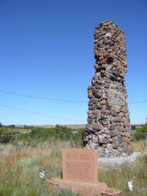
This stone chimney is all that remains of a one room country school house that served pioneer Amity pop. 119 from the early 1880's until closing in April 1930. The Amity Cemetery & Amity Ditch are the only other remains of this early Mormon . . . — — Map (db m36614) HM
On Main Street at West 2nd Street, on the left when traveling north on Main Street.
After the original frame school house burned in 1930, this building served Eagar's children for 53 years. Mothers prepared hot lunch across the street creating Eagar's own depression era "soup lines" at 5 cents a cup for the children. — — Map (db m36628) HM
On East Main Street, 0.2 miles east of South Mountain Avenue, on the right when traveling east.
This bronze school bell summoned children until 1950. This 2 room adobe with high pitched roof & bell tower was added onto with brick, altering the entry & roof in 1927 & again in 1950. The school served the community 99 years. — — Map (db m36653) HM
On Lehner Road, 2 miles north of Palominas Road & State Highway 92, on the left when traveling east.
At this location in 1952, a large bone bed was discovered containing the remains of extinct mammoth, tapir, bison and horse. Found with the bones were the weapons and tools of the Indians who had killed and butchered these animals. The bones and . . . — — Map (db m43633) HM
Constructed in 1956, the William Carmichael Elementary School was the first school to be built in the new Sierra Vista School District. The school first opened its doors on September 5, 1956, with 16 classrooms for 500 children in grades . . . — — Map (db m83848) HM
Near West Mars Hill Road, 0.6 miles west of West Santa Fe Avenue.
Lowell Observatory has been designated a Registered National Historic Landmark Under the provisions of the Historic Sites Act of August 21, 1935 this site possesses exceptional value in commemorating or illustrating the History of The . . . — — Map (db m149455) HM
Near West Mars Hill Road, 0.6 miles west of West Santa Fe Avenue.
A gift to the Observatory from President A. Lawrence Lowell through this instrument the ninth planet Pluto was first found in 1930 ”It means a planet out there as yet unseen by Man, but certain sometime to be detected and added to the . . . — — Map (db m149454) HM
The Horace M. Albright Training Center is a National Park Service facility for employee development. Established in 1963 and named for the National Park Service's second director, the training center serves as an educational program center for . . . — — Map (db m39602) HM
Responding to mounting political and public pressure, Congress authorized a ten-year program in 1955 to regenerate and modernize the national parks dubbed "Mission 66" for the target date of 1966, the National Park Service's 50th anniversary. The . . . — — Map (db m39587) HM
On Turner Street, on the right when traveling south.
This property
has been placed on the
National Register
of Historic Places
By the United States
Department of the Interior
Bullion Plaza
School
1923
— — Map (db m67493) HM
On North Highway 87 (U.S. 87) 0.1 miles south of Randall Drive (Arizona Route 260), on the left when traveling north.
The Pine Community Center Historic District is listed on the National Register of Historic Places. The historic buildings of the district are the LDS (Latter Day Saints/Mormon) Ward Chapel, built in 1915-1916, the Cultural Hall, completed in 1931, . . . — — Map (db m67416) HM
On Fossil Creek Road, 1.8 miles west of State Route 87, on the right.
The Strawberry School is listed on the National Register of Historic Places. Built by pioneers in 1885, this one-room cabin provided elementary instruction to students until 1916. The building represents the effort to teach the "Three Rs" in rural . . . — — Map (db m35837) HM
On Central Road east of U.S. 70, on the left when traveling east.
First home of the present Eastern Arizona College was Central's red-brick churchhouse located just north of this marker. Founded December 1890 The many-named school moved the next year to Thatcher. — — Map (db m28054) HM
Near South Gilbert Road south of West Elliott Road, on the right when traveling south.
This is the third elementary school in Gilbert and was built in 1913. The first two schools were part of the Mesa School District. Everett Wilbur, who later became Gilbert’s first mayor in 1920, donated the land where this school was built. The east . . . — — Map (db m94589) HM
On West Glendale Avenue east of North 63rd Avenue, on the right when traveling west.
This property
is listed in the
National Register
of Historic Places
By the United States
Department of the Interior
Glendale High School
Auditorium
1939 — — Map (db m30481) HM
On South Extension Road at West Main Street, on the right when traveling south on South Extension Road.
[Upper Marker]:
Mormon Church 2nd Alma Chapel meeting house, 1911. Sold, 1954 to Producers Insurance Company. First Campus Mesa Community College, 1963. Converted to a restaurant in 1973.
[Lower Marker]:
This is the site of . . . — — Map (db m49906) HM
On North 83rd Avenue north of West Madison Street, on the right when traveling south.
An early example of Mission Revival-Style architecture, this two-room masonry school was built in 1906 to accommodate the growing population of Peoria. The main architectural feature is the curvilinear parapet. After the city purchased the building . . . — — Map (db m30398) HM
Near West Washington Street near North 11th Avenue, on the left when traveling west.
Department of Library, Archives and Public Records
Board Members:
Frank Kelly, Chairman, Speaker of the House • Stan Turley, President of the Senate • John Hays, State Senator • Polly Rosenbaum, State Representative • Sharon Turgeon, . . . — — Map (db m27629) HM
Established 1891
This fountain and building erected 1922
Charles H. Burke
Commissioner of Indian
Affairs.
"The Indian will become an asset or a liability as we cultivate or fail to cultivate his body, mind and soul with a view . . . — — Map (db m62608) HM
Near South Ellsworth Road south of East Queen Creek Road.
In 1924 construction of a new schoolhouse began. Classes were being held in an old cook shack that had once been used by muleskinners to clear the land. The school, named after Charles Rittenhouse, would be a three-room, u-shaped building made of . . . — — Map (db m32393) HM
On Indian School Road at Miller Road, on the left when traveling east on Indian School Road.
An early Civic Leader of Scottsdale, Charles Miller purchased this property and the 120 acres to the North and West from Scottsdale founder Winfield Scott.
He with two others Founded the Scottsdale Light and Power Company, which brought . . . — — Map (db m40594) HM
Near Scottsdale Mall, 0.5 miles east of North Brown Avenue.
State Plaque:
Scottsdale Grammar School
Dedicated February 26, 1910
on the 73rd birthday of
Scottsdale's founder
Chaplain Winfield Scott
This building served the
people of Scottsdale as
School
Community Center . . . — — Map (db m34173) HM
Near East Scottsdale Mall, 0.2 miles east of North Brown Avenue.
Scottsdale's founder, a minister, Civil War hero, member of the Territorial House of Representatives and Chancellor of the University of Arizona who promoted the dusty desert east of Phoenix is honored here by the citizens of Scottsdale for his many . . . — — Map (db m49936) HM
Built in 1919 to replace the original Tempe Normal School dining hall, this building was informally named to honor Robert and Martha Krause, who managed it as steward and matron for 30 years. Krause Hall was later remodeled as a cafeteria and was . . . — — Map (db m159155) HM
On South Farmer Avenue, on the right when traveling south.
Begun in 1885, this adobe house was completed in February 1886 by Hiram Bradford Farmer. Professor Farmer was the first principal and sole instructor of the newly founded Territorial Normal School, now Arizona State University. Unofficially the . . . — — Map (db m27560) HM
On North Tegner Street (Arizona Route 93), on the right when traveling north.
Has been entered in the
National Register
of Historic Places
By the United States
Department of the Interior
Little remains of the old one room schoolhouses built of log, adobe, frame or brick which proliferated across Arizona in . . . — — Map (db m29476) HM
On General Crook Street, on the left when traveling east.
The Club House was constructed by the Bureau of Indian Affairs in 1930 to provide housing and kitchen facilities for unmarried teachers employed at the Theodore Roosevelt School. The building was later converted to a clubhouse for use by the school . . . — — Map (db m36784) HM
Near Barracks Row, on the left when traveling west.
These ruins represent the last surviving enlisted men's barracks, on the east end of Barracks Row. Much like Officers' Row defined the north side of the Parade Ground, Barracks Row made up the south side. This adobe barracks was one of two . . . — — Map (db m209362) HM
On Scout Street, on the left when traveling north.
Throughout the military history of Fort Apache, enlisted men were housed with their units to the south of Officers' Row. The first company quarters, completed in February 1871, were 18 by 20 foot log squad huts built in rows running north and south . . . — — Map (db m36807) HM
On Barracks Row, on the right when traveling west.
The Boys' Dormitory was constructed in 1932. Located on the east end of the fort's Parade Ground, it is on the site of earlier military structures including a telegraph office. Sandstone was quarried for the building's construction from a site . . . — — Map (db m36875) HM
On General Crook Street, on the left when traveling east.
An 1891 fire, sparked by a defective chimney and fanned by high winds, destroyed five sets of wood frame officers' quarters that had been constructed in this area between 1883 and 1886.
Using sandstone quarried just east of the Fort, these two . . . — — Map (db m36779) HM
On Barracks Row, on the right when traveling west.
During the first decade of the Theodore Roosevelt School, girls were housed in the old fort hospital. Since the old barracks that housed the boys was inadequate, a new boys' dormitory was scheduled for construction in 1931. Before that construction . . . — — Map (db m36878) HM
This stone guard house was built around 1891 to replace the earlier, bed-bug infested structure still standing about 300 feet to the west of this site. Placed near the original main entrance to the fort, this building provided housing for guards . . . — — Map (db m36805) HM
On General Crook Street, on the left when traveling east.
Constructed in 1888 in the architectural style of Fort Apache's Officers' Row, these residences housed junior officers or non-commissioned officers and their families.
Like other quarters on the east end of Officers' Row, these residences were . . . — — Map (db m36800) HM
On General Crook Street, on the left when traveling east.
These three officers' quarters were constructed between 1883 and 1888 to house junior officers and their families. With clipped-corner porches and symmetrical front elevations, these quarters reflect the architectural style established by the . . . — — Map (db m36796) HM
Near Fort Apache Road, on the right when traveling west.
The first guardhouse at Fort Apache was built of logs and located on this site. In 1876, this stone building – the second oldest surviving structure on the post – was constructed to replace the original log structure. It was replaced as . . . — — Map (db m36806) HM
On General Crook Street, on the right when traveling east.
This large open field between Officers' Row and the enlisted men's Barracks Row was used by the army for drill practice, training, and review. When called to action, troops would assemble here prior to departure. It also provided a prime location . . . — — Map (db m36781) HM
This stone cafeteria building was constructed in 1948-1949 to serve the students of the Theodore Roosevelt School. It is the last building constructed here that is part of the Fort Apache Historic District. Before the construction of this building, . . . — — Map (db m36877) HM
On General Crook Street, on the left when traveling east.
This house was constructed by the Bureau of Indian Affairs around 1930 to house Theodore Roosevelt School teachers and families. It deviates in style, though not in size, from the typical Officers' Row quarters.
Initially the house had a flat . . . — — Map (db m36803) HM
On January 24, 1923 an act was passed by Congress authorizing the Secretary of the Interior to establish and maintain an Indian boarding school on the site of Fort Apache. The first students were Dine' (Navajo) children brought from the Navajo . . . — — Map (db m36876) HM
On Pinedale Road, 0.7 miles south of Arizona Route 260, on the left when traveling south.
For 75 years this bell tolled throughout Pinedale Valley as a symbol of unity, calling the settlers to school, church and socials and warning of disaster. Purchased in 1892, it hung for many years in a log schoolhouse near this site. Later it was . . . — — Map (db m36666) HM
On Shumway Road, 0.2 miles east of Arizona Route 77, on the left when traveling east.
One of the remaining one-room brick schoolhouses in Northern Arizona was built in 1900 of fired brick.
The school was named for Charles Shumway who settled in Spring Valley (now Silver Creek Valley) in 1878 and built a grist mill for wheat and . . . — — Map (db m36738) HM
On West Esperanza Avenue at West Vananda Avenue, on the left when traveling west on West Esperanza Avenue.
Curley School
built 1919
has been listed in the
National Register
of Historic Places
by the United States
Department of the Interior
January 31, 2008 — — Map (db m195863) HM
On South Main Avenue, on the right when traveling south.
Carrillo School was named for the prominent Tucson businessman, Leopoldo Carrillo. During the 1880's, the site contained the Carrillo Gardens, the city's first park with eight acres of spring-fed artificial lakes, gardens and a recreational center. . . . — — Map (db m83016) HM
On West Pennington Street, on the right when traveling west.
On November 18, 1867, the Pima County Board of Supervisors created Tucson School District 1. An old adobe building at this location was refitted for classes. Desks and benches were built, new windows were installed in the 25' x 40' classroom, and . . . — — Map (db m83010) HM
On South Church Avenue at West McCormick Street, on the right when traveling south on South Church Avenue. Reported missing.
Named in 1869 for the convent located adjacent to San Augustín Cathedral. When the seven Sisters of St. Joseph of Carondelet finally arrived in 1870, they opened the city’s first parochial school for girls next to San Augustín. Three years later . . . — — Map (db m186125) HM
On East Speedway Boulevard west of North Santa Rita Avenue, on the right when traveling west.
Dr. William Austin Cannon had this house built during 1904-1905. He was the first resident botanist with the Carnegie Desert Laboratory in 1902, and worked there until 1926. Dr. Cannon sold the house in 1913 to Dr. Andrew Ellicott Douglass, an . . . — — Map (db m83014) HM
On East Speedway Boulevard west of North Santa Rita Avenue, on the right when traveling west.
Dr. Smith built this house in 1904 in anticipation of his marriage to Maud North, a Tucson teacher. The house, which he designed, was the first building on the north side of Speedway. Dr. Smith was a University of Arizona professor of engineering . . . — — Map (db m83035) HM
On March 12, 1885 Governor Frederick A. Tritle signed legislation creating the University of Arizona. Selim M. Franklin and C.C. Stephens, Pima delegates to the 13th Territorial Legislature fathered this Bill. Jacob S. Mansfeld solicited the . . . — — Map (db m26386) HM
The bell in this clock tower is one of the two original ship's bells salvaged from the battleship U.S.S. Arizona following the attack on Pearl Harbor, December 7, 1941. In 1944, Wilber L. "Bill" Bowers, UA Class of 1927, discovered the bell . . . — — Map (db m31199) HM
On East 2nd Street, on the right when traveling west.
Rough Rider, mining engineer, developer of the Ajo copper mines and designer of the town of Ajo for Calumet and Arizona Mining Co., Brigadier General, Army Reserve, and Regent, University of Arizona.
The other original casting, . . . — — Map (db m41974) HM
On Arizona Route 79, on the left when traveling north.
Near this site on the evening of October 3, 1926, John "Button" Salmon, student body president and quarterback of the University of Arizona football team, was critically injured in a car accident while returning from a weekend in Phoenix with two . . . — — Map (db m26664) HM
On North Willow Street, on the right when traveling north.
Emma Monk came to Arizona Territory to teach school at Fort Thomas in the 1880s. She married William Guild in 1887 and taught school in Florence off and on from 1885 to 1897 and was the first Florence principal. She also taught in Red Rock, Casa . . . — — Map (db m68337) HM
On South Main Street, on the right when traveling south.
Designed by Phoenix architects Royal W. Lescher and John R. Kibbey and completed in 1916, this neo-classical revival style structure has overtones of the Spanish revival style. The school board chose a one story as the children would have already . . . — — Map (db m26623) HM
On North Grand Avenue at North Santa Cruz Street, on the right when traveling south on North Grand Avenue.
Grand Ave. School was founded in 1928 as a grammar school, grades one through eight, for the African American children of Nogales. In 1943 the school's name was changed to Frank A. Reed in honor of a former student, Frank A. Reed, who died in . . . — — Map (db m27113) HM
Near Little Outfit Ranch Road, 0.6 miles north of Canelo Pass Road.
National Historic Site
The Little Outfit School was opened in 1940 by Katharine (Pete) and Buel Hutchinson and was exemplary of the ranch schools for which Arizona became famous. It provided excellent academics experience in the ideals of . . . — — Map (db m78423) HM
On Calle Iglesia, on the right when traveling east.
In 1789, Toribio Otero received the first land grant in this area in exchange for teaching school at his ranch. A school district was established in 1876 and in 1885 T. Lillie Mercer built this school, one of the earliest in Arizona. It was in use . . . — — Map (db m27142) HM
On Main Street (Arizona Route 89A) at Verde Avenue, on the left when traveling east on Main Street.
You are standing at the second story entrance to what once was a three story primary school. The land was purchased, a bond was passed and construction began in 1913. It opened May 29, 1914 to graduate 3 seniors: Francis Lyons, Gertrude Rothermel . . . — — Map (db m33191) HM
Near East Gurley Street east of North Arizona Avenue.
There was a time when progress in Yavapai County was spelled S-P-A-R-K-E-S. Grace M. Sparkes came to Prescott, Arizona Territory, at the age of 14 in 1906. By 1911, she was working for the Yavapai County Chamber of Commerce as Secretary, a job she . . . — — Map (db m33137) HM
On Park Avenue near Coronado Avenue, on the left when traveling south.
In early 1908, the Prescott School Board decided that a new school was needed in Prescott. On July 12, 1908, a school bond election was held and approved by the voters 119-1. In August 1908, the three acre site on Park Avenue on the west side of . . . — — Map (db m33049) HM
On S. Montezuma Street (Arizona Route 89) near W. Gurley St and S. Montezuma St., on the left when traveling south.
Prescott, Yavapai County Seat, founded 1864 on Granite Creek, source of Placer gold. Named for William Hickling Prescott, Historian, first Gov. JN. N. Goodwin, Appointee of Abraham Lincoln. Established first territorial capital of Arizona here. At . . . — — Map (db m18805) HM
Near South Alarcon Street south of East Goodwin Street.
Prescott's modern public library was dedicated on May 18, 1975. However, the history of a public library in Prescott goes back to August 1895, when seven local ladies founded the Women's Club of Prescott (now the Monday Club). They gathered a . . . — — Map (db m52912) HM
On East Gurley Street (Arizona Route 89) at Marina Street, on the left when traveling west on East Gurley Street.
Prescott's first library consisted of over 300 volumes brought to the Territory in 1864 by Secretary of State Richard C. McCormick. In 1870, a group of local women opened a reading room with 263 books collected from local citizens and out-of-town . . . — — Map (db m20814) HM
On East Gurley Street east of South Alarcon Street, on the right when traveling west.
The first public school in Prescott was opened in 1867. In 1876 a four-room brick public school building was erected here. It was known as the "Prescott Free Academy". In 1903 that building was torn down and replaced by Washington School. Washington . . . — — Map (db m33094) HM
The Sedona Heritage Museum opened in 1998. It focuses on the history of the pioneer settlers of the greater Oak Creek area and those related historic themes that contributed to the settlement and development of Sedona.
The Museum is housed in the . . . — — Map (db m133693) HM
The Sedona Historical Society is a non-profit organization whose mission is to research, preserve and teach the history of the greater Sedona area. The Society plays an active and important role in local historic preservation and in displaying and . . . — — Map (db m133688) HM
The Sedona area’s earliest schools were built and run by residents without government support. The first school was a one-room building at the Schuerman property on Red Rock Loop Road in 1892. Olive Welch was the teacher and there were seven . . . — — Map (db m133565) HM
Near Castle Dome Mine Road, 10 miles east of U.S. 95.
In 1863 Jacob Snively, founder of Gila City, and right hand to Sam Houston, avenger of the Alamo, following blazes left on the saguaros by Mexican and Conquistador predecessors, came to Castle Dome, and within 15 years, Castle Dome City’s population . . . — — Map (db m48924) HM
The "New Yard" was constructed in 1900 to help relieve overcrowding. The entrance to the library was closed and the first four cells were made from the library excavation in the south bank. Eight more cells were dug into the east side of the same . . . — — Map (db m185959) HM
On Prison Hill Road west of South Levee Road, on the right when traveling south.
The concrete slabs in front of you were the floors of the shop buildings constructed in 1895. The shops housed the electric generating plant, shoe/ tailor shops and the laundry/bathhouse. The 33 foot x 100 foot adobe building had a corrugated iron . . . — — Map (db m191835) HM
Near Prison Hill Road, 0.5 miles north of Harold C. Giss Parkway.
The concrete slabs before you are all that remain of an early adobe structure. Originally, this building was where prisoners were processed, ate meals, and received medical attention. Later it housed offices, storerooms, barbershop and the two cells . . . — — Map (db m158297) HM