On Crabapple Road (Georgia Route 372) west of Birmingham Highway, on the right when traveling west.
The Cantrell and Nallie Reese House was built in 1912 by the Reese family. Cantrell was the son of Ervin and Ann Devore Reese. Nallie was the daughter of John Broadwell, a prominent cotton farmer and merchant. These were early settlers in the area. . . . — — Map (db m118147) HM
Formerly known as the Old Birmingham Hotel, the building was constructed by Thomas B. Newton, Jr. around 1865. It originally stood next to Hickory Flat Road, but was relocated here in 2007 to preserve it. The building served in numerous capacities . . . — — Map (db m118174) HM
On Brittle Road, 0.4 miles north of Bethany Road, on the right when traveling north.
Atlanta physician John Walker (1902-1977) purchased a 500 acre farm here in the 1930s. The barn was built in the late 19th century. Originally, the transverse frame barn, with several cribs, was joined together under one roof, separated by an aisle. . . . — — Map (db m118164) HM
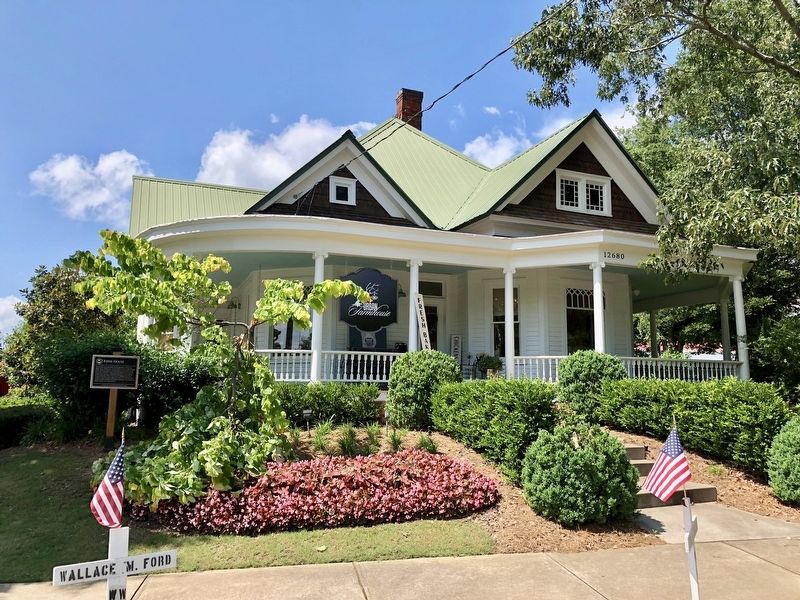
On Freemanville Road at Phillips Circle, on the right when traveling south on Freemanville Road.
This clapboard house was built in 1899 by Willis Cass Tucker, Jr., and his wife Dealphia Jane Wheeler on an original 40-acre land lot from the 1832 lottery of Cherokee Indian lands. It typifies turn of the century Georgia farmhouses. Tucker sold it . . . — — Map (db m118159) HM
On South Atlanta Street (Georgia Route 9) 0.2 miles north of Riverside Road, on the right.
circa 1840, built of handmade brick. Originally home and office of the Lauren Woolen Mill; Near Allenbrook is historic site of Laurel Woolen Mill (burned by Sherman’s Forces); Lovers Rock, popular antebellum picnic spot. — — Map (db m108987) HM
On Marietta Road (Georgia Route 120) at Barrington Drive, on the right when traveling east on Marietta Road.
Barrington King, co-founder of Roswell with his father, Roswell King, for whom the town is named, selected this spot for his home, which is in the Greek Revival style of architecture. Willis Ball, a carpenter from Connecticut, was the builder. After . . . — — Map (db m16647) HM
On Mimosa Boulevard at Pratt Street, on the right when traveling south on Mimosa Boulevard.
Built for D.H. Bradley by noted Atlanta architect Neel Reid, a Roswell resident from 1917-1926. The home exhibits Reid’s sense of scale and proportion. A later occupant was Charles Newton, a teacher at Roswell High School for 28 years and the . . . — — Map (db m109193) HM
On Canton Street at Woodstock Road, on the right on Canton Street.
Home of Charles Jefferson Perry who organized the Citizens Bank of Roswell and developed the north Roswell business district along present-day Canton Street in the late 19th Century. — — Map (db m109118) HM
On Mimosa Boulevard near Park Square Court, on the right when traveling south.
Greek Revival raised-cottage-style home of Savannah cotton broker Robert Adams Lewis. His wife was Catharine Barrington, as niece of town founder Roswell King. A later resident was noted author Evelyn Hanna, whose 1938 novel Blackberry Winter . . . — — Map (db m109119) HM
On Canton Street at Thompson Place, on the right when traveling north on Canton Street.
Two sisters, Miss Sallie Kimball and Mrs. V.L. Williams lived in this house which operated as the first boarding house in Roswell for a period of time. It had six bedrooms, each with a coal burning fireplace. Visiting ministers were welcome to come . . . — — Map (db m109213) HM
On Canton Street, 0.1 miles south of Woodstock Road, on the left when traveling south.
Built by Barrington King for Roswell Manufacturing Company textile mills manager H.W. Proudfoot. The columned portico and porte-cochere were added and the house enlarged in the 1920s by Harrison Broadwell. The house is named for his mother’s family. — — Map (db m109009) HM
On Mimosa Boulevard, 0.1 miles Marietta Highway (Georgia Route 120), on the left when traveling north.
Primrose Cottage was the first permanent residence constructed in Roswell. Built for Eliza King Hand, a daughter of town founder Roswell King, the home features a hand-turned fence executed by an English craftsman. The house was designed by . . . — — Map (db m109142) HM
Near Mill Street, 0.3 miles east of Atlanta Street, on the right when traveling south.
Roswell King’s primary objective from the very beginning was to establish a textile industry in the area.
In 1835, Roswell King purchased Land Lot #416 in the 1st District, 2nd Section, the location of the first cotton mill. Site preparations . . . — — Map (db m227978) HM
On Canton Street, 0.1 miles south of Woodstock Road, on the right when traveling north.
Originally constructed by a Cherokee Indian as a one room cottage with a fireplace. It was enlarged and the front entrance turned to face Canton Street in the early 1900s. The house was occupied for many years by Mr. & Mrs. Charles C. Fowler, . . . — — Map (db m109212) HM
On Goulding Place, 0.1 miles west of Canton Street, on the right when traveling west.
Once called Colonial Place this became the home of author, inventor, naturalist, and retired Presbyterian minister Dr. Francis R. Goulding (1810-1881) of Liberty County. In 1842 he built the first practical sewing machine, but never secured a patent . . . — — Map (db m113942) HM
On Norwich Street just north of Monck Street, on the right when traveling north.
In 1838 a small Methodist Brunswick congregation was assigned to a preaching circuit by the Florida Conference of the Methodist Episcopal Church. They worshiped in various locations including the 1840 Glynn Academy School House before building . . . — — Map (db m193486) HM
Near Newcastle Street at George Street, on the left when traveling north.
An Ornament for the City Despite its Colonial pedigree, Brunswick appears as a classic Victorian town. Many landmarks were built in the late 19th century, a period of emerging prosperity and civic pride. In 1884, the local newspaper praised the . . . — — Map (db m193672) HM
On Newcastle Street south of Gloucester Street, on the left when traveling south.
Jekyll Square, originally called “Jekyll Place,” was named after Sir Joseph Jekyll (1663-1738), a member of British parliament. He was a friend of General Oglethorpe—founder of Georgia—and a financial supporter of the . . . — — Map (db m155620) HM
On Newcastle Street (U.S. 25) north of Gloucester Street, on the right when traveling north.
The Journey Back to Machen Square
In January, 1958, the First National Bank of Brunswick sold its landmark building (left) on Machen Square West to the S.H. Kress Company, and the 64-year-old structure was demolished. The owner of the . . . — — Map (db m212675) HM
On Newcastle Street north of Mansfield Street, on the right when traveling north.
British humanitarian, leader and military commander, James Edward Oglethorpe (1696-1785), is credited as the founder of Georgia. His plan for the city of Savannah, later adapted for the design of Brunswick, included ample public green space. His . . . — — Map (db m212676) HM
On Riverview Drive, 0.2 miles north of Stable Road, on the right when traveling north.
With only drive and ambition, Frank Henry Goodyear rose from a $35-per-month bookkeeper to the head of a vast lumber, coal, iron, and railroad empire.
Far from viewing Jekyll Island as a place to escape the stresses of business, Goodyear took . . . — — Map (db m115120) HM
On Pier Road just west of Stable Road, on the right when traveling west.
It required an array of workers and a dedicated attention to detail to provide the superior service and Life of Luxury expected by the members of the Jekyll Island Club. The Club bookkeeper served an essential role in fulfilling those expectations . . . — — Map (db m227733) HM
Near Old Plantation Road north of Schoolhouse Lane, on the right when traveling north.
Constructed in 1904, this Italian Renaissance style cottage, which contained 20 rooms and 6 baths, was designed and built for Dr. George Frederick Shrady and his wife, Hester. In 1925 Hester Shrady sold the cottage to Walter B. James, then president . . . — — Map (db m164471) HM
On Pier Road east of Hopkins Avenue, on the right when traveling east.
The corridor of Pier Road was not only the hub of service for the Jekyll Island Club, it was also the heart of the community for countless employees.
Yes, here you would find a taxidermy shop, upholstery shop, coal storage, woodsheds and . . . — — Map (db m115093) HM
Near Pier Road east of Riverview Drive, on the right when traveling north.
The brick outline that you see in front of you marks the former Location of Fairbank Cottage.
When Chicago manufacturer Nathaniel Kellogg Fairbank purchased the lot in 1889, he was excited about the possibilities of his new cottage. Fairbank . . . — — Map (db m115121) HM
On Riverview Drive, 0.2 miles south of Stable Road, on the left when traveling south.
With a wife and nine children, Charles Stewart Maurice quickly decided accommodations at the Clubhouse would not suffice. In 1890, he built Hollybourne as a home away from home for their winter stays here on the island. Maurice was a bridge . . . — — Map (db m227671) HM
On Stable Road just south of Pier Road, on the left when traveling south.
From the beginning of the Jekyll Island Club, members realized they would need stables on the island for the use of its members and staff. In 1887, landscape architect H.W.S. Cleveland suggested plans for a stable to be located behind the . . . — — Map (db m227653) HM
What to do when you require privacy from the overflowing crowds of guests at the Clubhouse, but want to take advantage of its world-class French chef, new billiards wing, and the cheerful fireplace of the main parlor ? The answer for Henry B. . . . — — Map (db m75571) HM
On Old Plantation Road at Pier Road, on the right when traveling north on Old Plantation Road.
By 1905, tennis was gaining popularity on the island over hunting. Robert Pruyn, chairman of the committee on golf and sports, said, "For two years, tennis has been the most popular outdoor sport," and requested additional courts to be . . . — — Map (db m115118) HM
On Old Plantation Road north of Schoolhouse Lane, on the right when traveling north.
Chartered by the State of Georgia to be trustworthy stewards of the island, the Jekyll Island Authority has been very active in the preservation of the National Historic Landmark District. The rehabilitation of Crane Cottage and Cherokee in . . . — — Map (db m115119) HM
On Riverview Drive near Major Horton Drive, on the right when traveling north.
Tabby was the building material for walls, floors, and roofs widely used throughout coastal Georgia during the Military and Plantation Eras. It was composed of equal parts of sand, lime, oyster shell and water mixed into a mortar and poured into . . . — — Map (db m17578) HM
On Riverview Drive, 0.3 miles south of Stable Road, on the left when traveling south.
Edwin Gould purchased Chichota cottage within 5 days of his first visit to Jekyll Island in December of 1900. He quickly began modifying the cottage for his family’s arrival in March. Edwin made a commitment to the Island, purchasing several . . . — — Map (db m72663) HM
On Pier Road at Riverview Drive, on the right when traveling west on Pier Road.
The Executive Committee hired architect Charles Alexander to design the Clubhouse. He designed the building in a Queen Anne style that complemented the natural beauty of the island and emphasized the rustic simplicity that the Jekyll Island Club . . . — — Map (db m115117) HM
On Old Plantation Road west of Stable Road, on the right when traveling west.
On the Move
When first constructed in 1890, Furness Cottage stood as a lone sentry in the southern portion of the Club compound.
The growing popularity of cottage construction led to its first move, off of Riverview Drive.
. . . — — Map (db m115114) HM
Near Old Plantation Road at Hopkins Avenue, on the right when traveling south.
Early in the morning, early in the century, it happened: Solterra caught fire. Built by charter member Frederick Baker in 1890, the house was an emblem of the nineteenth century: proper, discrete, upright. The old century seemed to be going . . . — — Map (db m72668) HM
Near Mimosa Drive, 0.2 miles west of Frederica Road.
”Frederica was once a pretty little town, as appears by the ruins, having been burned down some years since.” Colonel S. Elbert May 1777 The house that stood on these ruins was a two-story duplex with tabby walls, and elegant . . . — — Map (db m168380) HM
On 12th Street south of Beachview Drive, on the right when traveling south.
The Lighthouse and Keeper's Dwelling were completed in 1872, replacing the Lighthouse destroyed during the Civil War. Orlando Poe, chief engineer for the U.S. Lighthouse Board, supervised the design. Charles Cluskey, the architect of many . . . — — Map (db m106303) HM
Near Chatsworth Highway (Georgia Route 225) 0.4 miles east of Newtown Church Road NE, on the right when traveling east.
Two Cherokee families headed by Elijah Hicks and Alexander McCoy were among the first residents of New Echota. Both families were already living here when New Echota became the capital in 1825. Their farms once included most of what is now the golf . . . — — Map (db m161553) HM
On North Main Street at East North Street, on the right when traveling north on North Main Street.
This church was organized on September 23, 1863, by the Right Reverend Stephen Elliott, the first Bishop of Georgia. Its original members included two Greensboro families and several women who had migrated inland from Charleston and Savannah to . . . — — Map (db m184198) HM
Near North Main Street just north of East Green Street, on the right when traveling north.
Federal Works Agency Public Works Administration John M. Carmody Federal Works Administrator ————— Franklin D. Roosevelt President of the United States ————— City of Greensboro Mayor and Council . . . — — Map (db m197886) HM
Near Clean Water Drive, 0.8 miles south of Plunkett Road.
One of the oldest surviving homes in Gwinnett County, this house was built in the 1850s. The house was originally two rooms wide and one room deep. This style is referred to as an I-house. The house is unique because of the beautiful, hand painted . . . — — Map (db m107606) HM
On West Crogan Street (Georgia Route 8) at South Perry Street (Georgia Route 20), on the right when traveling east on West Crogan Street.
Dedicated in Memory of William Carroll Jackson
(1934 - 2004)
Constructed by Miles E. Ewing in 1895, the hotel was originally three stories tall with gingerbread balconies that wrapped around the corner of the then unpaved Crogan and Perry . . . — — Map (db m197705) HM
On Linton Road, 0.3 miles south of Pearson Chapel Road, on the right when traveling south.
Confederate Colonel Theophilus Jackson Smith built Glen Mary as a gift to his wife, Mary Salome Gonder. The estate would become a major cotton producer in Middle Georgia before the Civil War. The house is considered by many as the finest Greek . . . — — Map (db m106811) HM
On Hamilton Street at Boland Street, on the left when traveling east on Hamilton Street.
The main cemetery in Sparta was established on property deeded to the town in 1806. Burials illustrate a common nineteenth-century pattern of migration to the area, as settlers from New England and Virginia moved south and west through the Carolinas . . . — — Map (db m13378) HM
Near Discovery Parkway at West Harris Street (Georgia Route 18).
Constructed from hand-hewn
longleaf pine logs. Built around
1830 during the settlement of
Troup County, Georgia. Moved
to its present location in 1959. — — Map (db m107904) HM
Near Discovery Parkway at West Harris Street (Georgia Route 18).
A smokehouse is a structure used to cure
meat and fish. It is typically a small
building with no windows where meat is
smoked and stored. A slow burning fire
dries the meat over a period that can range
from a few hours to a few weeks. . . . — — Map (db m107905) HM
On Rome Street at Ricefield Road, on the right when traveling south on Rome Street.
Hartwell, Georgia
Recognized for its “Architectural and Historical Significance”
by the
State of Georgia
Department of Natural Resources Historical Preservation
and the
National Registry-of Historic Places
by the
United States . . . — — Map (db m185375) HM
On Macon Street (U.S. 23) 0.2 miles north of College Street, on the left when traveling north.
[First plaque]
Built by Andrew McBride
Revolutionary soldier
in the 1820s
Dedicated by
Governor Robert Daniell Chapter
National Society Daughters of the American Colonists
[Second plaque]
This property . . . — — Map (db m186575) HM
On North Armed Forces Boulevard at Watson Boulevard, on the right when traveling north on North Armed Forces Boulevard.
This property has been placed on the
National
Register
of Historic
Places
January 2, 2008
by the
United States Department of the Interior — — Map (db m197988) HM
Near Etheridge Road just south of Johnson Mill Road, on the right when traveling south.
Tenants from this farm and neighboring farms came here to purchase a wide range of household supplies — many no doubt relying on credit advanced by Mr. Ira — so its crossroads location near to the main house was ideal. In its heyday, this . . . — — Map (db m184377) HM
Near Etheridge Road just south of Johnson Mill Road, on the right when traveling south.
This garage was built in 1923. Its prominent location opposite the main house and substantial construction using concrete blocks reflect Mr. Ira's enthusiasm for automobiles. Joyce Ethridge remembered that he liked to buy the latest models and . . . — — Map (db m184393) HM
Near Etheridge Road just south of Johnson Mill Road, on the right when traveling south.
Although Mr. Ira was keen to keep abreast of the latest developments in farming, most of the work on his cotton farm was still done by a combination of mule and human muscle-power. In the 1940s there were 26 mules on the farm that were used to till . . . — — Map (db m184400) HM
On Etheridge Road just south of Carruth Road (Johnson Mill Road), on the left when traveling south.
This Piedmont Homestead, originally settled by brothers James and Patrick Shields in 1798, contains a collection of intact historical buildings on a total of 152 acres set aside for preservation. This is one of the most diverse collections of farm . . . — — Map (db m184289) HM
Near Etheridge Road just south of Johnson Mill Road, on the right when traveling south.
This house was built around 1912 as a tenant sharecropper's place and would probably have had three or four outbuildings including a chicken house, a small barn, a well house, and a privy. The original building was a two-room cabin. The chimney at . . . — — Map (db m184398) HM
Near Etheridge Road just south of Johnson Mill Road, on the right when traveling south.
This tall wood-framed building was used both as a granary and as a place to store farm equipment. Like the garage, it faces the main house and so it has some ornamental features, notably a balcony above the front door. But this balcony was more than . . . — — Map (db m184396) HM
On GA-17/GA-23/GA-67 (E Winthrope Ave), on the right when traveling west.
Jenkins County was organized from territory cut from Burke, Screven, Bulloch, and Emanuel counties in 1905, and officially began its function as a new political unit on Jan. 1, 1906.
The first court house was completed in March, 1908 and burned . . . — — Map (db m13149) HM
On West Main Street (Georgia Route 122) 0.1 miles west of North Pine Street, on the right when traveling east.
Eurith Dickinson Rivers was governor of Georgia from 1937 to 1941. He actively supported President Franklin D. Roosevelt’s New Deal Program. Rivers’ innovative leadership produce Georgia’s first Department of Public Welfare, free school books, the . . . — — Map (db m22996) HM
On West Court Street at West Street, on the right when traveling east on West Court Street.
One of the first houses built in Hinesville after the town was established and became the county seat of Liberty County in 1837 was that of Charlton Hines, a state senator and for whom the town was named. This house, considerably altered, was . . . — — Map (db m41645) HM
On East Court Street (State Highway 38) 0.1 miles east of North Commerce Street, on the right when traveling west.
The Bacon-Fraser House was built on a 23 acre tract situated on the eastern boundary of the town of Hinesville in 1839 by Mary Jane Bacon, widow of Major John Bacon. The house has been owned and lived in by their heirs until the present time. The . . . — — Map (db m15844) HM
On East Main Street (Georgia Route 122) at North Nelson Street, on the right when traveling west on East Main Street.
A two story school building was constructed and dedicated on this site in 1932 as the Hahira High School. It replaced an earlier school building that had burned down. Bishop Nelson donated the land for the school. Later additions of an auditorium . . . — — Map (db m195852) HM
On East Central Avenue (U.S. 84/221) just west of North Lee Street, on the right when traveling west.
Built 1908-1910 Formerly a United States Post Office and Federal courthouse designed by U.S. Treasury Department Architect J. Knox Taylor Rehabilitated and restored by the City of Valdosta Rededicated in 2010 216 East Central . . . — — Map (db m197662) HM
On North Park Street at Hawkins Street, on the left when traveling north on North Park Street.
This church was originally built by the Presbyterian congregation in Dahlonega in 1899. In 1962, the church was purchased by the Roman Catholic Archdiocese of Atlanta. Renovations by the Glenmary Home Missioners began that same year. In August 1963, . . . — — Map (db m183292) HM
On North Public Square at North Chestatee Street, on the right when traveling west on North Public Square.
Hall’s Block was built between 1882 and 1883 by Captain Frank W. Hall to house his Merchandise Company, Captain Hall came to Dahlonega from Vermont in 1867 as a gold mining equipment salesman and engineer. He also served as a legislator, mayor, . . . — — Map (db m123734) HM
On Public Square North at South Chestatee Street, on the left when traveling west on Public Square North.
The prospering town of Dahlonega needed a suitable courthouse to replace the temporary log one. The well-known North Carolina carpenter and builder Ephraim Clayton was contracted for its construction. It was completed in 1836.
For the next . . . — — Map (db m123726) HM
On Church Street at West Main Street, on the right when traveling south on Church Street.
This arch was donated to the college by the graduating class of 1951.
By tradition, it is considered to be unlucky for freshmen to walk under the college arch.
Over the years, a path was formed where freshmen detoured around the arch. . . . — — Map (db m181835) HM
On College Circle east of West Main Street, on the right when traveling east.
The majority of the native gold, approximately 11 ounces of the required 13, used for building the steeple of this building was donated by R.D. Hogue and was mined from his Josephine Mine in Auraria Georgia, Lumpkin County. — — Map (db m182636) HM
On 4th Avenue east of South 4th Street, on the right when traveling east.
Grove Hill Militia District Courthouse
Built around 1875
Donated to Colbert Community in memory of Mr. and Mrs. and Harold Gaulding, Sr. by Mr. and Mrs. Harold Gaulding, Jr. — — Map (db m181832) HM
Near Rock House Road, 0.2 miles west of West Bypass Road, on the right when traveling west.
This 18th Century stone dwelling is the only surviving house associated with the Colonial Wrightsboro Settlement (1768). Its builder, Thomas Ansley, used weathered granite, quarried in its natural form from the nearby geographical fall line, as . . . — — Map (db m227207) HM
On Rock House Road, 4 miles west of Georgia Route 223, on the right when traveling west.
This 18th Century stone dwelling is the only surviving house associated with the Colonial Wrightsboro Settlement (1768). Its builder, Thomas Ansley, used weathered granite, quarried in its natural form from the nearby geographical fall line, as . . . — — Map (db m9809) HM
On South Main Street (U.S. 278) at Jones Alley, on the right when traveling west on South Main Street.
As the county gained more plantations, Madison attracted nearby planters desiring to shop, socialize, learn, and worship. Some planters also built in-town homes. Antebellum architecture reflected the shift from the early yeoman farmer society to a . . . — — Map (db m45734) HM
On Bethany Road, 0.1 miles north of Madison Bypass (U.S. 129/441), on the right when traveling north.
Common among the counties during the settlement period, Morgan County (1807) first transacted public business at a private residence - Fields Kennedy's home. After Madison was designated as the county seat in 1808 until the construction of a formal . . . — — Map (db m109716) HM
On Academy Street at Porter Street, on the right when traveling east on Academy Street.
Like Madison's high-style architecture, its formal landscapes were Southern translations of both prevalent trends and earlier traditions. Boxwood gardens were an antebellum landscape feature gracing many Madison homes. Parterres were a garden form . . . — — Map (db m49601) HM