On Water Street at Market Street, on the right when traveling south on Water Street.
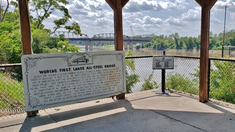
In 1877, the Chicago & Alton Railroad decided to build a bridge across the Missouri River at Glasgow. It was to be the first large all-steel bridge in the world. Mr. A.F. Hay, of Burlington, Iowa, had developed a steel that met all specifications & . . . — — Map (db m216963) HM
On South Main Street just north of East Pacific Avenue, on the right when traveling north.
The home of Dr. and Mrs. Bryant was built ca. 1867, and expanded to its present Queen Anne-Eastlake design by ca. 1890. Dr. Bryant was a prominent physician and successful businessman. Harriet Smart was the daughter of Judge Thomas A. Smart, a . . . — — Map (db m144703) HM
On Maple Avenue near North Spring Street, on the left when traveling east.
The earliest Society of Methodists in the county was founded in Independence in 1835 with 10 charter members. Methodists have worshipped on this corner since 1840. The present Gothic style church, completed in 1859, was refaced and added to in 1929 . . . — — Map (db m34749) HM
On South Main Street at West Linden Avenue, on the right when traveling north on South Main Street.
The Misses Mollie and Josie Hughes hired the architectural firm of Gibbs and Parker, Kansas City, MO., to design this ornate Queen Anne style residence. Erected in 1887, it was one of a group of mansions on Main Street owned by the Bryant-Hughes . . . — — Map (db m140405) HM
On Walnut Street at Lynn Street, on the right when traveling east on Walnut Street.
Martin Kritser, a grocer, bought this lot in 1847 and probably had the house built soon after. Patrick McCarty, one time saloon keeper on this square, bought it in 1849. This modest house is typical of the majority of houses built during the city's . . . — — Map (db m34843) HM
On West Farmer Avenue just west of North Spring Street, on the right when traveling west.
In 1856 this Greek Revival and Italianate style house was completed by William McCoy, a merchant and banker, on property once owned by Samuel C. Owens, a merchant and Santa Fe trader. McCoy served as the first Mayor of Independence, MO., in 1849. — — Map (db m144541) HM
On North Pleasant Street, 0.1 miles north of West Truman Road (Missouri Route 12), on the right when traveling north.
The 1890 Queen Anne House was the home of James C. and Maggie Noel. James Noel was a city councilman 28 years. Both were close friends of Harry and Bess Truman. — — Map (db m140406) HM
On South Pleasant Street, 0 miles south of West Walnut Street, on the right when traveling north.
Built about 1850 by John A. Overfelt, a flour miller, in the then current Gothic style. Acquired in 1867 by Courtney Campbell, it is now the home of his granddaughter, Miss Harriett Campbell Johnston. Listed on the National Register of Historic . . . — — Map (db m140458) HM
On North Delaware Street just south of West Waldo Avenue, on the right when traveling south.
Erected in 1887 by Aaron Flint Sawyer, a partner in the Chrisman - Sawyer Banking Company, this Queen Anne style residence is the design of T.B. Smith, a talented Independence, Mo., architect and builder. — — Map (db m140794) HM
On North Spring Street, 0 miles south of West White Oak Street, on the right when traveling south.
Mr. and Mrs. Charles Lindsay Minor acquired this home ca. 1900. Mrs. Minor was the former Nancy M. McCoy, daughter of William McCoy, an early Independence business man and the first Mayor at the time of the city’s incorporation in 1849. Their . . . — — Map (db m144551) HM
On West Lexington Avenue just east of South Proctor Place, on the right when traveling west.
About 1866 this brick house, in the then popular Italianate style was built by Samuel Hughes Woodson, lawyer, United States Congressman, 1856-1861, Circuit Judge, land developer, and stage and mail route operator. — — Map (db m144554) HM
On U.S. 40 at East 36th Street, on the left when traveling east on U.S. 40. Reported permanently removed.
This imposing farm mansion was erected in 1855 for B.F. Thomson by his slaves. The Thomson family fled during the Civil War. In 1866 the farm was sold on the courthouse steps to Rev. J.D. Gossett. One of the finest Greek Revival mansions in Jackson . . . — — Map (db m233659) HM
On Main Street at East 34th Street, on the right when traveling north on Main Street.
These Queen Anne row houses were constructed in the 1880s and became known as Rat's Castle. Janis Joplin is rumored to have lived here in the 1960s. — — Map (db m198769) HM
On 39th Street at Gillham Road and Harrison Parkway, on the left when traveling east on 39th Street.
The Pennsylvania Railroad Company presents this statuary to the Kansas City Area Council, Boy Scouts of America, in recognition of Scouting's contribution to this nation and as a lasting tribute to those who have earned its highest award
The . . . — — Map (db m44395) HM
Near East 36th Street at Janssen Place, on the right when traveling east.
Originally platted as part of the City of Westport and intended as a planned, residential area, Janssen Place was conceived and developed by Arthur E. Stilwell, an urban planner and railroad magnate who founded Kansas City Southern and other . . . — — Map (db m194979) HM
On East 5th Street west of Forest Avenue, on the right when traveling west.
The Garrison Field House, now Community Center, was designed by Benjamin Lubschez, an architect with Adriance Van Brunt and Company. When completed in 1914 for more than $55,000, the field house included an administrative office, gymnasium, . . . — — Map (db m242814) HM
On Missouri Avenue at Campbell Street, on the right when traveling east on Missouri Avenue.
In loving memory of Robert Bisbee, and in gratitude to his wife, Carol Bisbee, for designing, building and installing the cross on Holy Rosary's bell tower on the 10th of September 2003. — — Map (db m64000) HM
On West Pershing Road at Main Street, on the right when traveling west on West Pershing Road.
Following the flood of 1903, Kansas City's original Union Depot, located in Kansas City's west bottoms, was rebuilt on this site in 1914 as Union Station and heralded as one of the most beautiful train stations, and the third largest passenger rail . . . — — Map (db m198768) HM
On Main Street at 47th Street (U.S. 56), on the right when traveling south on Main Street.
The sculptures of the J.C. Nichols Memorial Fountain were originally created by French sculptor Henri Leon Greber in 1910 for a fountain in the formal garden at Harbor Hill, the Long Island, New York estate of Clarence and Katherine . . . — — Map (db m88233) HM
On J. C. Nichols Parkway at 47th Street (U.S. 56), on the left when traveling south on J. C. Nichols Parkway.
J. C. Nichols was one of those rare individuals, a dreamer with a capacity for making his dreams come true. He dreamed more over in terms of great practical benefit to his city, few men can have so variously and profoundly influenced the . . . — — Map (db m88238) HM
Near Brookside Avenue, 1.3 miles south of East Winner Road (U.S. 24), on the right when traveling south.
William Rockhill Nelson, visionary force in the development of Kansas City, was born March 7, 1841, in Fort Wayne, Indiana.
In September 1880 he arrived in Kansas City with business partner, Samuel Morss, and they launched the newspaper that . . . — — Map (db m144140) HM
On Baltimore Avenue at West 40th Street, on the right when traveling south on Baltimore Avenue.
Built in 1855 by John and Henrietta Harris this Greek revival style all brick house was located on a slightly five acre tract on the ridge just east of Westport, MO. This site was on the southwest corner of Westport Rd. (Santa Fe Trail) and Main . . . — — Map (db m44411) HM
On 47th Street (U.S. 56) at J. C. Nichols Boulevard, on the right when traveling west on 47th Street.
Dedicated in 1967
in recognition of our sister city
Seville, Spain
—————————
Seville Fountain
Cleaves-Bessmer-Marietti, Inc.
adopted this fountain for restoration
through the . . . — — Map (db m88239) HM
On Volker Boulevard (U.S. 56) 0.2 miles east of Rockhill Road, on the right when traveling east.
Making the choice of organ and tissue donation will save lives, provide hope, and spare families the needless loss of loved ones. Kansas City is the first city in the country to have a special fountain honoring organ and tissue donors. "Joie de . . . — — Map (db m88275) HM
On East Broadway Street at North Landreth Avenue, on the left when traveling east on East Broadway Street.
Before the city of Joplin was incorporated in 1873, there were two distinct lead and zinc mining communities called Murphysburg and Joplin City. Joplin Creek divided the townships, with Murphysburg located to the northwest and Joplin City to the . . . — — Map (db m230307) HM
On Elm Street just south of Main Street (Missouri Highway BB), on the right when traveling south.
Governor Thomas C.
Fletcher House
Built c. 1851
has been placed on the
National Register
Of Historic Places
by the United States
Department of the Interior
— — Map (db m144699) HM
On Main Street south of Gay Street, on the right when traveling south.
Here in 1870, George Graham Vest delivered his Eulogy to the Dog in the Old Drum Case. The building served as a seat of justice, a meetinghouse, and vital record keeper in the county's formative years. It was the scene of a murder, Civil War . . . — — Map (db m85353) HM
On Water Street north of Market Street, on the right when traveling north.
When memory keeps me company and moves to smile or tears,
A weather-beaten object looms through the mist of years,
Behind the house and barn it stood, a half a mile or more—
And hurrying feet a path had made, straight to its swinging . . . — — Map (db m85373) HM
Truss Structures
Kingpost
The kingpost was the first and simplest truss structure used in America. Its basic idea consists of a center post, the kingpost, with compression beams slanting downward and outward toward each shore. The . . . — — Map (db m67182) HM
This barn was built by volunteers in the summer of 2001 to help celebrate Walt's 100th birthday. It was constructed using the blueprints Walt had commissioned for his own Holmby Hills workshop.
Autographs and messages to Walt and Roy are . . . — — Map (db m198807) HM
On South Main Street (Business U.S. 61) just north of Hamilton Street, on the right when traveling north.
Gardner House
Built 1828
has been placed on the
National Register
of Historic Places
by the United States
Department of the Interior — — Map (db m150338) HM
On East Main Street at South Broadway Street, on the left when traveling west on East Main Street.
On April 6, 1846 The City of Princeton had its beginning when 22 Lots were sold. It was named for the battle in which General Mercer, the county's namesake, was killed. Samuel Speer owned the site and had a dwelling, a stable and a blacksmith shop. . . . — — Map (db m188198) HM
Today's 4-H Building has served many purposes over the years, originally named the Poultry Building to serve the needs of the poultry department.
In the 1930s, it was designated as the Missouri Building, housing the Missouri State Exhibit from . . . — — Map (db m85034) HM
The earliest cattle barn, the Shorthorn Barn, was built in 1904 to replace barns destroyed by fire. The barn has round arched entrances accented by pilasters enclosing a decorative brick parapet.
The 1905 Hereford Barn uses pilasters that extend . . . — — Map (db m85094) HM
The westernmost cattle barn, with the typical round arches and terra cotta trim, houses Aberdeen Angus Cattle.
The easternmost 1907 barn houses Jersey Cattle. It is considered to be the most decorated cattle barn, perhaps because it was the . . . — — Map (db m85095) HM
The Coliseum, originally called the Livestock Pavilion, has traditionally been used for showing and judging livestock and for horse shows. In addition, four presidents who have visited the Fairgrounds have spoken here –
William Howard . . . — — Map (db m85011) HM
Originally designed as the Palace of Agriculture, this 80' by 160' building was labeled the Horticulture Building by the Premium List of 1906, but the Agriculture Building by Program Books from 1915, 1918, and 1920. Postcards from 1908 through . . . — — Map (db m85017) HM
Named for Governor Sam A. Baker, the Historic Administration Building is a two-story building of buff-colored brick. Originally the building included a cafeteria and sleeping rooms for department superintendents. It now houses the Missouri State . . . — — Map (db m85015) HM
The Poultry and Rabbit Building was originally used to display machinery. In order to allow for adequate ventilation, the original building had no roof but was covered with an awning during the Fair.
The building was named the Missouri Building . . . — — Map (db m85025) HM
On Thompson Avenue at 4th Street, on the left when traveling south on Thompson Avenue.
The Sedalia Depot visitor center is the place to begin a Sedalia sightseeing tour. Building hours are posted on the door, and visitors are welcome to tour the historic building, discover the history of Sedalia's railroad culture and learn . . . — — Map (db m85311) HM
The Swine Pavilion originally housed swine and sheep. The building has a flat, three-tiered roof and square, hipped roofed towers on the northeast and southeast corners. The building lacks symmetry; the west wing was not completed as planned . . . — — Map (db m85091) HM
The Varied Industries Building was originally called the Horticulture Building, one of the most elaborate of the 1903 exposition halls.
Early Program Books and Premium Lists identify this as the Horticulture Building, though postcards from the . . . — — Map (db m85020) HM
These lintels were cast in the Maramec Iron Works circa 1866. After completion, the lintels were transported by wagon to "Dunmoor" the home of William James, 1870-79, and used on the west side to support the structure above the windows. The building . . . — — Map (db m157878) HM
A Midwestern city as a hotbed of artistic expression? You bet. Here in Kansas City, you’ll discover a wealth of superb arts and cultural offerings. From the extraordinary exhibits and architecture of The Nelson-Atkins Museum to the excitement of . . . — — Map (db m43200) HM
If you wanted a steak in New York before 1867, you pretty much had to wait until your dinner came in on four legs from Texas to the railheads in central Missouri, and finally hitched a train to Chicago. It was there that cattle were unceremoniously . . . — — Map (db m43199) HM
Like Cinderella, Kansas City’s famous Country Club Plaza wasn’t always a glittering princess. In the late 1890s, the area, known as Brush Creek Valley, was still a marshland populated by beavers and foxes, and tread only by fur trappers, Native . . . — — Map (db m43190) HM
On Short Street at Welt Street, on the left when traveling east on Short Street.
Two story 3 brick thick Federal style with flanking chimneys. 6 fireplaces. Original pine floors & woodwork. Restored 1990, by Mr. & Mrs. Glen Payne. — — Map (db m77145) HM
On Washington Street at Thomas Street, on the left when traveling north on Washington Street.
Federal style church erected by Presbyterian congregation. Since 1934, the Weston Christian Assembly Church. Weston's only remaining church building of the 1840's. — — Map (db m44545) HM
On Main Street (State Highway 10) at College Street, on the right when traveling west on Main Street.
This planter is constructed of cornices from the 1856 courthouse which was moved from this location in 1915, the sandstone base once served as a step for the building. — — Map (db m157020) HM
On Main Street (State Highway 10) at College Street, on the right when traveling west on Main Street.
Original columns supporting the Court Room of Ray County's Courthouse (1856-1913).
Stone for plaque base-first Recorder's Office, preserved and donated to the Citizens of Ray County by Randall G., Marvel C. Barber and Harold . . . — — Map (db m157022) HM
On Main Street west of 4th Street, on the right when traveling east.
This Classical Revival Style structure was built by prominent businessman J.A.J. Aderton as a family home. The architecture transitions from the orderly Federal Style (1780-1830) to the decorative Italianate buildings of the Victorian Era . . . — — Map (db m246739) HM
On Main Street east of 8th Street, on the right when traveling east.
Dr. William Price (b. 1812, d. 1865) began his practice here in 1835 and built this two-story federal style house about that time. Slave quarters and stables once stood to the rear. Price married Mary Ellen Sappington (b. 1819, d. 1904) the daughter . . . — — Map (db m246738) HM
On Missouri Route 41 at Visitors Center Drive, on the left when traveling north on State Route 41.
The Lawless House
D Lawless and his wife Martha Anne Dawson Lawless built this Queen Anne style farmhouse in 1903. They had been raising their family of eleven girls and one son in the log home of his father, Burton Lawless, just south of . . . — — Map (db m246748) HM
On Missouri Route TT west of Pin Oak Lane, on the right when traveling south.
Saunders Townsend (1787-1876) was one of the first settlers in the Arrow Rock neighborhood, having arrived in the Lamine Township from Kentucky in 1819. A slave owner, he became one of the largest land owners in the area, having received land grants . . . — — Map (db m246867) HM
On Walnut Street west of Public Street, on the right when traveling west. Reported unreadable.
September 8, 1881, the "St. Charles "Democrat" reported that Dr. Hampson Strother Clay intended to become a physician in Augusta. Before locating in Augusta, Dr. Clay, an 1873 graduate of the Missouri Medical College, had lived in Darst Bottom where . . . — — Map (db m133208) HM
On Locust Street just west of Lower Street, on the left when traveling west.
Staudinger-Grumke
House-Store
has been placed on the
National Register
of Historic Places
by the United States
Department of the Interior
1857 — — Map (db m169480) HM
Near Highway F, 0.1 miles south of Boone Ridge Trail, on the right when traveling south.
The Daniel Boone Home, Defiance, Missouri, stands in an enchanting wooded hillside setting surrounded by stately elms, including the 16½-ft. girth Judgment Tree. This four-story Georgian-style structure is as staunch and solid as the . . . — — Map (db m169494) HM
Near Highway F, 0.1 miles north of Defiance Road, on the right when traveling south.
Isaac McCormick
House
This property
has been placed on the
National Register
of Historic Places
by the United States
Department of the Interior
c. 1867
— — Map (db m169489) HM
Near State Highway F, 0.2 miles south of Boone Ridge Trail, on the right when traveling south.
The Boone's constructed their home from Missouri Blue Limestone with the help of water. They drilled holes into the stone, filled them with water in Fall and Winter, and waited for the freezing water to expand and crack the stone. — — Map (db m169513) HM
Near Lucille Avenue west of Missouri Highway 94, on the right when traveling west.
From Matson to Weldon Spring is 4.6 miles, one of the shortest distances between trailheads in Katy Trail State Park. Defiance, at milepost 58.9, is less than two miles from Matson. It received its name after preventing Matson from having the . . . — — Map (db m133209) HM
On Mill Street just south of Groenberger, on the left when traveling north.
Butler Bro's General Store
3669 Mill Street
has been placed on the
National Register
of Historic Places
by the United States
Department of the Interior
1850 — — Map (db m169511) HM
On Jefferson Street west of North 10th Street, on the right when traveling east.
This "castlelike" abode built in 1895 is in style, Richardsonian Romanesque—an innovatively modified amalgamation of both Romanesque and Byzantine features. The interior is an architectural equivalent to the exterior, combining aesthetics . . . — — Map (db m133252) HM
On Jefferson Street west of North 10th Street, on the right when traveling east.
Joseph and Genevieve Stoltz built this house as their residence in 1884. Stoltz was the proprietor of the Central House Hotel and Saloon on Main Street in St. Charles.
This home features a hand-painted fireplace imported from Germany, sliding . . . — — Map (db m133251) HM
On Jefferson Street east of Kingshighway (Missouri Highway 94), on the right when traveling east.
Built in the late 1800's, this Country Victorian home retains many of the attributes of the period.
Using balloon framed construction, the exterior finish includes a tin roof and wood siding with square head nails, and bubble glass windows . . . — — Map (db m133250) HM
On Jefferson Street east of Kingshighway (Missouri Highway 94), on the right when traveling east.
This Queen Anne cottage was built in 1904 for Fred W. Eisner. In the early 1920's, Paul Draudt and his wife Lottie owned the house. Mrs. Daudt was President of the National Bank of Commerce on Main Street.
In 1955, the home was purchased on the . . . — — Map (db m133249) HM
On Jefferson Street east of Kingshighway (Missouri Highway 94), on the right when traveling east.
This home was built in 1964 by the William Wolter family for the sum of $3,300.00 and remained in the family until 1980. The house is of Folk Victorian design with a stone foundation. The roof is a gable and hip design with overhanging eaves. The . . . — — Map (db m133247) HM
On South Main Street south of Jefferson Street, on the right when traveling north.
When John Platz built this building in 1863 for his grocery and his daughter's dressmaking shop, he actually owned only half of his north wall and only half of his south wall. The practice of sharing walls was not usual in St. Charles, and these . . . — — Map (db m124831) HM
On South Main Street south of Jefferson Street, on the right when traveling north.
Behind this 1914 Art Deco tile and marble facade is one of the oldest buildings on the street, the Masonic Hall. The lodge held its last meeting on July 17, 1861. "About this time [1861], we came under the dark Cloud of War between the North and . . . — — Map (db m124830) HM
On North 3rd Street just north of Randolph Street, on the right when traveling north.
(c. 1876) This romantic front gabled home was built in 1876 by Theodore Mertens, who died shortly thereafter. Upon his death, the home was willed to Christoph Mertens, a minor. In 1878, the home was auctioned off on the courthouse steps for $595.00. . . . — — Map (db m169572) HM
On North 3rd Street close to Randolph Street, on the right when traveling north.
Built circa 1894 by Otto & Augusta Hischke, Prussian immigrants. The house has a shotgun floorplan of brick made in Frenchtown on a raised foundation of locally quarried and cut "Burlington" limestone.
The Victorian Vernacular has Steamboat . . . — — Map (db m169574) HM
On South Main Street at Madison Street, on the right when traveling west on South Main Street.
An earlier two-story structure, known as the Old Benne Building built by Joseph C. Easton circa 1840, was replaced by this building in 1882. The new Second Empire /Italianate building with its parade balcony and bracketed cornices and pediments . . . — — Map (db m124825) HM
On North Main Street north of Jefferson Street, on the left when traveling north.
Emil Weil bought two brick buildings on this site that were joined with a common wall that separated a tailor shop from a meat market. When Weil raised the old buildings to rebuild, he kept the functionality of the common wall, which separated his . . . — — Map (db m124856) HM
On North 6th Street north of Lewis Street, on the left when traveling north.
1834
John and Herman Wilke arrived from Hanover, Germany.
1850's
John and Herman established successful farms in Portage Des Sioux Township, now Orchard Farms.
1860's
John and Herman both served for the Union during the Civil War, . . . — — Map (db m133256) HM
On North 6th Street at Franklin Street, on the right when traveling north on North 6th Street.
1830 - Part of Nathan Boone's survey of the Commons.
1835 - Part of Andrew Wilson's 999 year lease of the Commons ground.
1876 - Census of St. CHarles Township lists the family of Henry Kroetter (farmer) and wife Catharine and six . . . — — Map (db m133264) HM
On North 6th Street north of Franklin Street, on the right when traveling north.
1830 - Part of lot 11 Nathan Boone's survey of the Commons.
1835 - Part of Dr. Wilson's subdivision of the commons.
1900 - Lot was purchased by Joseph H. Etling and his wife Anna (nee Broeckelmann). Joseph was a carpenter who . . . — — Map (db m133265) HM
On North 5th Street just north of Franklin Street, on the left when traveling north.
1830 - Part of Nathan Boone's survey of the Commons
1837 - Andrew Wilson leased this and other land from Morgan to Seventh
1870 - This block sold to Henry G. Holtforester and Herman H. Schaberg.
1911 . . . — — Map (db m169226) HM
On North Main Street south of Monroe Street, on the left when traveling north.
The decorative façade, with elaborate stone window surrounds and stone quoining, invites comparison to the fancy sugar pastries and candies sold here from 1879 to 1909 by Henry Pfeiffer, a confectioner from Braunschweig, Germany.
Henry . . . — — Map (db m124864) HM
On North Main Street south of Monroe Street, on the right when traveling north.
This 1906 Renaissance Revival building with its Italianate pressed metal ornamentation at the windows and cornice replaced the burned out Central Mill built in 1866 and the old Constitutional Presbyterian Church built in 1845. Rechtern bought the . . . — — Map (db m124868) HM
On North Main Street south of Monroe Street, on the left.
Ahmann's Newsstand and the Quality Hat Shop shared this double-front building in 1903. The Craftsman/Art Deco yellow glazed brick facade was added in 1934 when the newsstand expanded. The building may date to 1865. — — Map (db m124865) HM
On North Main Street south of Monroe Street, on the left when traveling north.
Thro & Company Clothing, formerly a 137 N. Main (shown above), has been owned and managed by the Thro family since 1898 when Jean Baptiste Thro, Sr., and his nephew Jean Baptist Thro, Jr., founded the clothing store. J.D. Thro, Senior's Unlce . . . — — Map (db m124866) HM
On North Main Street south of Monroe Street, on the right when traveling north.
This Italianate building with elaborate wood bracketed cornices has been described as a "structure unsurpassed in the quality of dignity." It has been home to Walter's Jewelry since 1935. From 1906 until 1935, Edward Schubert, pianist, composer and . . . — — Map (db m124867) HM
On Jefferson Street at North 3rd Street on Jefferson Street.
This brick home was built in 1895 by Henry B. Denker as a wedding gift for his daughter and her husband, William Rechtern. The Rechterns later gave the home as a wedding gift in 1950 to their son, Ralph, and his wife, Esther, who lived here until . . . — — Map (db m162675) HM
On North 6th Street north of Lewis Street, on the right when traveling north.
In 1830, still in the afterglow of the Louisiana Purchase, Nathan Boone was contracted to survey the lands of Missouri that would be recognized as St. Charles. By 1835, this plot resided within Andrew Wilson's subdivision. The first person . . . — — Map (db m133258) HM
On Jefferson Street west of South 7th Street, on the right when traveling east.
This picturesque house, built in 1938, has an asymmetrical design consistent with the architectural style of a Cotswald Cottage. It features many charming details including the steep, gabled roof, original lead diamond windows, and arched . . . — — Map (db m133255) HM
On North 5th Street just south of Franklin Street, on the right when traveling north.
(c. 1915) First paper physical evidence of this house appears on the 1917 Sanborn Fire Map. Agnes Alexander sold the property to Lana Anderson. An American Four square style of architecture having a bracket cornice on the front porch. Columns have . . . — — Map (db m169228) HM
On Jefferson Street east of South 9th Street, on the right when traveling east.
This the Henry Ehlmann House, probably built in 1873. Situated very close to the street, this 1½-story brick Federal style house has a side-gabled roof trimmed with an entablature having a cornice with corbelled brick dentils and an . . . — — Map (db m133254) HM
On North 3rd Street just north of Franklin Street, on the left when traveling north.
(c. 1865-1875) In 1882 was owned by a Mr. Cunningham and purchased by Emil and Clara Borgmeyer in 1916. After being condemned and scheduled for demolition in the spring of 2002, this Federal style house, with a Victorian porch, was rescued. Several . . . — — Map (db m169570) HM
On Jefferson Street east of South 9th Street, on the right when traveling east.
This home was built concurrently with construction of buildings for the 1904 World's Fair in St. Louis.
In 1943 it was acquired from Emma Wilke by Allie & Bertie Becker under the somewhat unusual consideration of loyalty, friendship, love . . . — — Map (db m133253) HM
On North 5th Street just north of Decatur Street, on the left when traveling north.
1815 - Wallace Kirkpatrick, of Scottish nationality, arrived in St. Charles from South Carolina. He was one of the first merchants in St. Charles, later residing on property near St. Charles and became a successful farmer. He married Miss Jane . . . — — Map (db m169215) HM
On North 5th Street just north of Franklin Street, on the left when traveling north.
1830 - Part of the Nathan Boone Survey of the Common Fields.
1837 - 999-year lease for $4.62 ¾ per year to Dr. Andrew Wilson. Dr. Wilson worked as the coroner of St. Charles County, as well as other occupations. He was a relative of Woodrow . . . — — Map (db m169223) HM
On North 5th Street just south of Franklin Street, on the right when traveling south.
1830 • Part of Nathan Boone's survey of the Commons.
1837 • Part of Dr. Andrew Wilson's lease of the Commons
1857 • Partitioned among the heirs of Dr. Andrew Wilson who subdivided the area as Wilson's subdivision.
1893 . . . — — Map (db m169220) HM
345 entries matched your criteria. Entries 101 through 200 are listed above. ⊲ Previous 100 — Next 100 ⊳