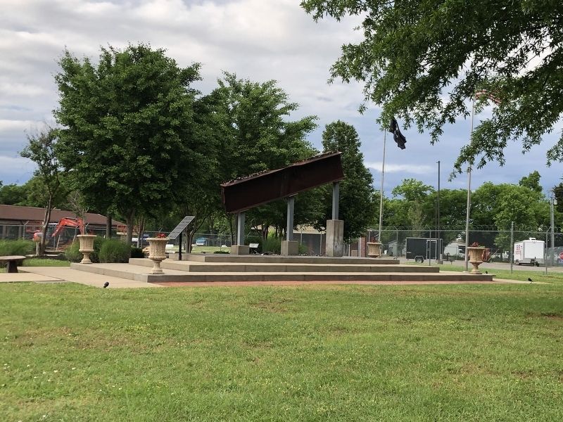
This monument memorializes those who died or were injured
on September 11, 2001. The Rutherford County Sheriff's Office
and volunteer supporters created it as a memorial to the 2,977
people killed and more than 6,000 injured in the September . . . — — Map (db m271992) HM WM
This view of a tree-lined East Main Street was taken from the courthouse cupola by an unknown photographer.
In the left foreground is the Cumberland Presbyterian Church, constructed in 1859. The congregation was unable to complete the . . . — — Map (db m82333) HM
Almost all of the buildings that surround the courthouse now date from after the Civil War.
Constructed in a restrained frugality more than stylistic choice, these structures replaced the earlier stores and warehouses that composed the . . . — — Map (db m69155) HM
One of Tennessee’s early country music performers was the irrepressible singer and banjo player, Uncle Dave Macon, the “Dixie Dewdrop.”
David Harrison Macon, was born in the tiny hamlet of Smartt Station in Warren County, and spent . . . — — Map (db m90691) HM
One of Tennessee's early country music performers was the irrepressible singer and banjo player, Uncle Dave Macon, the "Dixie Dewdrop."
David Harrison Macon was born in the tiny hamlet of Smartt Station in Warren County, and spent his teenage . . . — — Map (db m202907) HM
Luminaries such as James K. Polk,
David Crockett and Andrew
Jackson walked the streets while
the Legislature was in session.
Public demand for a more centrally located seat of government in Rutherford
County had increased considerably . . . — — Map (db m208313) HM
In 1977, Murfreesboro Pediatrician, Dr. Robert Sanders and his wife Patricia, encouraged the Tennessee General Assembly to pass the nation's first law requiring child safety in automobiles. Because every state followed the lead of Dr. Sanders and . . . — — Map (db m146636) HM
The Rutherford County Courthouse is one of only six remaining antebellum courthouses in the state of Tennessee.
Erected between 1859 and 1861 at a cost of $50,000, the Greek Revival-style brick structure features classical columns on the east . . . — — Map (db m69135) HM
This view of the square looks to the west and depicts several wood and canvas "shebangs” that sheltered the Federal troops guarding the Provost Marshal's Office downtown.
The soldiers constructed these makeshift shelters from all kinds of . . . — — Map (db m146741) HM
In 1811 the Tennessee state legislature appointed town commissioners to select the site for a new Rutherford County seat to replace Jefferson, the county's first county seat. The site was selected in 1812 by the commissioners. The proposed new town . . . — — Map (db m146780) HM
Rutherford County was created in 1803 from parts of Davidson and Williamson counties. The county was named in honor of Griffith Rutherford, an Irish immigrant who rose to the rank of brigadier general in the Continental army during the Revolutionary . . . — — Map (db m69142) HM
Murfreesboro's first experience with Federal occupation came in March 1862, shortly after the fall of Fort Donelson.
Headed by Brig. Gen. Ormsby M. Mitchel, Union cavalry entered the town, hoisted the United States flag to the top of the . . . — — Map (db m146745) HM
For whom this county was named in 1803.
In the early years of the Revolutionary War he commanded all Military Forces west of the Alleghenies
(Text on back)
1776: Appointed Brigadier General - led 2400 men into the Tennessee . . . — — Map (db m221035) HM WM
The last state to leave the Union, Tennessee became the first to reenter in 1866. But the end of the Civil War did not bring an end to hardships. No other state except Virginia experienced more military engagements than Tennessee. Roads, bridges, . . . — — Map (db m189008) HM
Born in Alabama, in 1893 Mary Ellen Vaughn, a graduate of Tuskegee Institute (now Tuskegee University), Chicago Business College, and Tennessee A & I College (now Tennessee State University), lived in Murfreesboro, Tennessee, the last thirty years . . . — — Map (db m160569) HM
A tombstone can only tell so much about the life of a man. From the shape and standard design of the markers you see ahead, you can tell that two veterans of the United States military lie here in graves just outside of the wall of the Hazen Brigade . . . — — Map (db m82570) HM
On March 24, 1865, Union Gen. George Stoneman led 6,000 cavalrymen from Tennessee into southwestern Virginia and western North Carolina to disrupt the Confederate supply line by destroying sections of the Virginia and Tennessee Railroad, . . . — — Map (db m253441) HM
John P. Buchanan, the 28th governor of Tennessee, was born in Williamson County on October 27, 1847. After serving in the Confederate Army, he moved to Rutherford County. In 1887, he was elected to the Tennessee House of Representatives. Three years . . . — — Map (db m82460) HM
On March 24, 1865, Union Gen. George Stoneman led 6,000 cavalrymen from Tennessee into southwestern Virginia and western North Carolina to disrupt the Confederate supply line by destroying sections of the Virginia and Tennessee Railroad, the . . . — — Map (db m12890) HM
Rutherford County was established on October 25, 1803 from portions of Davidson, Williamson and Wilson counties. The county originally extended to Alabama on its southern boundary. The county was named for Revolutionary War
General Griffith . . . — — Map (db m146773) HM WM
Bedford, drained by the Duck River and it’s tributaries, is noted for the Tennessee Walking Horse National Celebration at Shelbyville and Webb School at Bell Buckle, founded in 1870 by Sawney Webb, “father of preparatory school education in the . . . — — Map (db m200241) HM
Rutherford County recalls Revolutionary War Major General Griffith Rutherford, whom President Washington appointed to the legislative council of the Southwest Territory, later Tennessee. Murfreesboro has the distinction of occupying the state’s . . . — — Map (db m200238) HM
In 1834, the State of Tennessee hired Professor James Hamilton to find its geographic center in order to locate the state capital as near as possible to the center of the state. However, certain circumstances and politics left the capital in . . . — — Map (db m258073) HM
(Front): Rutherford County Established 1803; named in honor of Maj. Gen. Griffith Rutherford of the Revolutionary Army; appointed by President Washington as a Member of the Legislature for the Southwest Territory, which later became the . . . — — Map (db m82569) HM
This is the Sam Davis Home, one of Tennessee’s most significant Confederate memorial properties. Samuel (“Sam”) Davis, born here in 1842, enlisted in the Rutherford Rifles (Co. I, 1st Tennessee Infantry) in 1861 and fought in western . . . — — Map (db m82592) HM
Early 1900s Expansion of public schools in city and county.
1907 Tennessee College for Women opens.
1911 Middle Tennessee State Normal School opens.
1913 Tornado ravages downtown.
1914 Rutherford County . . . — — Map (db m207996) HM
With a family fortune built upon agriculture, land speculation, slavery, medicine, textiles, and other ventures, the Maneys were heavily involved in the economic, religious, and educational development of Murfreesboro. Like many wealthy Southern . . . — — Map (db m90996) HM
“Wetlands are among the most important ecosystems on Earth.”
-William J. Mitsch and James Gosselink
Natural resource and environmental ecologist
Bottomland Hardwood Forest
The wetlands at Oaklands are characterized as . . . — — Map (db m90687) HM
Rutherford County native DeWitt Smith Jobe was a member of Capt. Henry B. Shaw’s Coleman’s Scouts, a Confederate cavalry unit and spy network that served the Army of Tennessee. The men operated behind Union lines, remaining out of sight in the . . . — — Map (db m69079) HM
Smyrna is home to the busiest general aviation airport in Tennessee. The airport's modern services and economic contributions have their roots in its history as a training base for many of the nation's military pilots.
Smyrna Airport was . . . — — Map (db m171197) HM
Murfreesboro and Rutherford County, located in the center of Tennessee, became a major Civil War battleground from the summer of 1862 to late 1864. Union troops occupied the historic Rutherford County Courthouse on the Murfreesboro Square in the . . . — — Map (db m152089) HM
On March 24, 1865, Union Gen. George Stoneman led 6,000 cavalrymen from Tennessee into southwestern Virginia and western North Carolina to disrupt the Confederate supply line by destroying sections of the Virginia and Tennessee Railroad, . . . — — Map (db m266614) HM
(preface)
For two weeks in July 1862, Col. Nathan Bedford Forrest led 1,400 cavalrymen through Middle Tennessee to raid, scout and disrupt the Union Army of the Cumberland’s operation there. Leaving McMinnville on July 13, Forrest fought . . . — — Map (db m69157) HM
This distinguished race of men are more savage than the Indians,and possess every one of their vices, but not one of their virtues. I have known...these fellows (to) travel 200 miles through the woods never keeping any road or path, guided by the . . . — — Map (db m252535) HM
The Leeman House is a two-story log structure from Eastern Rutherford County. The circa 1820s front section was made with cedar tree trunks fitted together by skillful notching. The second story rear was a circa 1870s addition.
The house layout is . . . — — Map (db m90669) HM
The citizens of occupied Murfreesboro had constant reminders of the powerful federal army entrenched here on their doorsteps. From January 1863 to April 1866, "the streets were crowded at all times with wagons and soldiers....Soldiers camping thick . . . — — Map (db m37889) HM
Murfreesboro
First settlers came in 1799; the settlement was first named Cannonsburg. It was actually founded in 1811, on land donated by Capt. William Lytle, who stipulated that the town should be named for Hardy Murfree, a Revolutionary . . . — — Map (db m149642) HM
(Front):
Born Oct. 6, 1842 Near Smyrna, Rutherford County Tennessee.
Though a Confederate Soldier in the line of duty, he was executed as a spy by the Federals at Pulaski, Nov. 27, 1863.
"Let come what must, I keep my Trust." Sam . . . — — Map (db m81563) HM
Reconstruction began when the Civil War ended in 1865. The war had saved the Union, and the 13th Amendment to the U.S. Constitution ended slavery. Ratified during Reconstruction, the 14th and 15th Amendments guaranteed citizenship and voting rights . . . — — Map (db m146101) HM
Born in Tennessee, friend of David Crockett, Jesse Billingsley came to Texas in 1834. Known as a fearless Indian fighter, Billingsley was elected captain of the Mina Volunteers, Company C, of the Republic of Texas Army. At the Battle of San Jacinto, . . . — — Map (db m205479) HM
The Cherokees
Greenville County was Cherokee Territory before the Revolution. European settlers were forbidden to live here until 1777, when Native Americans were forced to cede this land to the new state. Most of modern day Greenville was . . . — — Map (db m14535) HM
Vardry McBee purchased more than 11,000 acres around the Reedy River from Lemuel Alston in 1815. Although McBee lived in Lincolnton, North Carolina, he wished to develop his Greenville property, and in 1819 he build a "superior" brick corn mill on . . . — — Map (db m28093) HM
[East Face - Top Inscription]:
Prospect
Hill
Park
[East Face - Bottom Inscription]:
Established by
Greenville County
Historic Preservation
Commission
[North Face - Top Inscription]:
Site of . . . — — Map (db m11584) HM
The mortal remains of
James Knox Polk
are resting in the vault beneath.
He was born in MecKlenburg County
North Carolina
and emigrated with his father
Samuel Polk to Tennessee
in 1806.
The beauty of virtue
was illustrated in . . . — — Map (db m85552) HM
Three principal Indian and pioneer trails
cut across Rutherford County connecting
the Great Lakes to the Gulf of Mexico and
the Atlantic Coast substantially following
animal trails to salt and water. Great South
Trail continued to Alabama and . . . — — Map (db m158268) HM
(front):
Murfreesboro>
First settlers came in 1799; the settlement was first named Cannonsburg. It was actually founded in 1811 on land donated by Capt. William Lytle, who stipulated that the town should be named for Hardee Murfree, a . . . — — Map (db m168572) HM
The Smith family, early colonial settlers and Patriots during the American Revolution, were relatives and neighbors of such prominent Virginians as the Washingtons, Lees and Randolphs. Maj. Robert Smith and wife Mary Jarratt, their son Col. John . . . — — Map (db m286650) HM
Callie Guy House was born into slavery in
Rutherford County, Tennessee, in 1861. In 1883
she married William House and moved to this
neighborhood. Widowed, she supported her
five children as a washerwoman while working
for the National . . . — — Map (db m310590) HM
1783 North Carolina Legislature creates Davidson County, which includes parts
of present-day Rutherford County.
1786 North Carolina Legislature makes initial land grants in Stones River area.
1788 Last elk in county is killed . . . — — Map (db m207990) HM
Holes in Geology
Beneath your feet is a vast system of caves and aquifers, formed in layers of limestone. From the surface, we see evidence of this karst landscape in sinkholes and springs.
The limestone, which varies in thickness . . . — — Map (db m207999) HM
Thin black lines indicate changes in relevance. Between each pair of lines entries are ordered geographically but all have the same relevance.
* Inflectional forms of words are their plurals, singulars, and possessives as well as gramatical tenses and similar variations.