108 entries match your criteria. The first 100 are listed. The final 8 ⊳
Erecting Organization Name with All of the Phrases «preservation society» AND «charleston»
This list will also include matches for inflectional* forms of the words. The following noise* words you entered were ignored: of, the. If one or more of these words are required for a successful search, go to the Other Ways to Search page and use the Google Search from there.
Charleston Naval Yard Officers' Quarters Historic District Marker, `
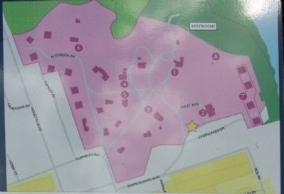
Charleston Naval Yard Officers' Quarters Historic District Map
On Everglades Avenue at Navy Way, in the median on Everglades Avenue.
In 1895 the City of Charleston purchased lands formerly part
of the Retreat and Turnbull Plantations and commissioned the
Olmsted Brothers of Massachusetts to design a recreational
public park. Chicora Park, named for the local Chicora . . . — — Map (db m66781) HM
On North Hobson Avenue near 4th Street, on the left when traveling north.
The Charleston Navy Yard Historic District contains 57
contributing structures and was listed on the National
Register of Historic Places in 2006. Construction of the Navy
Yard began in 1901 as a response to the emergence of the
United States as . . . — — Map (db m66756) HM
To meet the needs of an expanding navy, in 1899 the United States Naval Committee solicited proposals to build a new ship construction and repair facilities. At the urging of South Carolina Senator Benjamin "Pitchfork" Tillman and Charleston Mayor . . . — — Map (db m66987) HM
On Drake Street at Columbus Street, on the right when traveling north on Drake Street.
Cigar Factory This five-story commercial building, built in 1882 as a textile mill, was known as the Charleston Manufacturing Company, then Charleston Cotton Mills, in its early years. Leased to the American Tobacco Company in 1903, the plant . . . — — Map (db m67363) HM
On Broad Street, 0.1 miles King Street, on the left when traveling east.
Notable for its fine Georgian
paneling, this was home and
office to Dr. David Ramsay,
the distinguished patriot,
Revolutionary Historian and
physician. Dr. Ramsay
introduced the Small Pox
vaccine to Charleston
and helped found the . . . — — Map (db m27447) HM
On Ashley Avenue at Doughty Street, on the left when traveling north on Ashley Avenue.
Civil rights marches on Ashley Ave. and elsewhere occurred during strikes at two
hospitals from March 20 to July 18, 1969. Workers, mostly black women, cited unequal
treatment and pay when they organized and walked out of the Medical College . . . — — Map (db m182111) HM
On Meeting Street north of Ladson Street, on the left when traveling north.
This Georgian-era dwelling was constructed as the parsonage for St. Michael's Church by master builders Martin Miller & John Fullerton, one of the earliest known partnerships of house builders in colonial Charleston. Reverend Robert Cooper, the . . . — — Map (db m242804) HM
On East Bay Street (Business U.S. 52) at Hasell Street, on the right when traveling east on East Bay Street.
283 East Bay Street is located in the Ansonborough neighborhood on a lot that was originally part of Rhettsbury, named for early-18th century owner William Rhett. By 1773, William Hendrick owned the corner lot that became 283 East Bay. Maritime . . . — — Map (db m242580) HM
On Church Street at Cumberland Street, on the right when traveling north on Church Street.
This corner building was constructed shortly after the end of the Civil War under the ownership of Ireland-native Mary Monaghan Molony, widow of John Molony, who purchased the property in 1854. Earlier structures on the site were destroyed in The . . . — — Map (db m242591) HM
On Meeting Street north of Tradd Street, on the right when traveling south.
Historical records indicate that this three-story single house was constructed between 1800 and 1802 for cabinet maker Philip Moore. Prior to the building's construction, the property served as part of brewer Daniel Bourget's large estate, which was . . . — — Map (db m242594) HM
On George Street, on the right when traveling east.
This three-story, masonry residence set on a raised basement was begun circa 1796 by Mrs. Frances Motte Middleton, daughter of Jacob and Rebecca Motte. The house was completed by Mrs. Middleton and her second husband and former brother-in-law, . . . — — Map (db m51273) HM
On Hasell Street at Maiden Lane, on the left when traveling east on Hasell Street.
This residence was constructed by Col. William Rhett (1666-1722), a prominent Charleston merchant and colonial militia leader. In 1706 he led a small fleet of local ships that repulsed a combined French and Spanish invasion of the city. Rhett is . . . — — Map (db m31849) HM
On Society Street, on the left when traveling east.
This substantial three-story Greek Revival Period Charleston single house is constructed of stucco-covered brick and features a two-tiered piazza with Tuscan columns and turned balusters, piazza screen and entrance door complete with pilasters, . . . — — Map (db m51485) HM
On Hasell Street east of Anson Street, on the right when traveling east.
Eliza Jones (1775-1846) purchased this lot in the aftermath of the Ansonborough fire of 1838. She was the granddaughter of Robert Gibson, a graduate of Oxford University, and a Grand Master Mason, who, according to family legend, played a role in . . . — — Map (db m135489) HM
On East Bay Street (U.S. 52) near George Street, on the right when traveling south.
C.- 1804
This significant single house was built by Benjamin DuPré, a French tailor, sometime after 1803. The entire area was known as “Gadsden’s Green” after Christopher Gadsden who divided this land into six wharf lots and 197 . . . — — Map (db m51826) HM
On East Bay Street (U.S. 52), on the right when traveling south.
Moses C. Levy, a Polish born King Street merchant, built this valuable Federal style single house between 1811 and 1816. The house is located on land originally owned by Henry Laurens, one of the wealthiest merchants in the United States and . . . — — Map (db m51808) HM
On Meeting Street south of George Street, on the left when traveling south.
This three and one-half story Federal style single house set on a raised basement was built in 1807 by Ms. Abigail Noyer on land purchased from Mr. Christen Belser. The Federal style is evidenced by the hipped roof, a main entrance with fanlight . . . — — Map (db m135494) HM
On Cannon Street just east of Smith Street, on the right when traveling east.
This two and a half story house was built circa 1856 by Stephen S. Lloyd. Constructed in the form of a
Charleston single house, the basement level is brick, laid in American bond. The upper stories are of
wood with Greek Revival and Italianate . . . — — Map (db m81288) HM
On State Street near Chalmers Street, on the right when traveling south.
This two-and-a-half story Charleston Single House is thought to be built by Frederick Wolfe after the fire of 1796, which destroyed much of the State Street area between Broad and Queen Streets. The house was moved back on its original lot at 21 . . . — — Map (db m50513) HM
On Broad Street, 0.1 miles east of Meeting Street, on the left when traveling east.
Built in 1796 by
Daniel Ravenel,
the Second of
Wantoot Plantation,
as a summer home
replacing an earlier building
destroyed in the great fires of that year.
The property came to
his wife in 1749,
having been owned since 1710 . . . — — Map (db m27512) HM
On Queen Street, 0.1 miles east of Church Street, on the right when traveling west.
These notable stuccoed brick tenements were constructed as rental property in 1803 by the William Johnson family.
William Johnson, Sr., originally from New York, was a blacksmith and planter revered at his death as a patriot having served in the . . . — — Map (db m27544) HM
On Broad Street, 0.1 miles west of Church Street, on the left when traveling east.
This handsome building, c. 1800 was constructed by Gilbert Chalmers. From 1810 to 1825 it was the home of Gov. John Geddes, who married the builder's daughter. During Gov. Geddes' term in office, Pres. James Monroe visited here. In 1867 Mary . . . — — Map (db m27514) HM
On Church Street at Chalmers Street, on the right when traveling north on Church Street.
This property, a part of one of the
original town lots in the Grand Model
of Charles Towne was bought by
Paul Douxsaint, merchant, planter, and
French Huguenot immigrant, in 1725.
The Charleston single house of French
type . . . — — Map (db m27543) HM
On Queen Street, 0.1 miles east of Church Street, on the right when traveling west.
The building at 20 Queen Street was built circa 1840 for use as a cotton warehouse. It is considered a notable example of vernacular warehouse architecture in Charleston, influenced by Roman Revival and West Indian architecture. In 1934, the . . . — — Map (db m27545) HM
On State Street at Queen Street, on the right when traveling north on State Street.
Theodore D. Wagner, an executive with the leading mercantile firm John Fraser & Co., constructed the building soon after purchasing the property in 1866. At the time, much of the surrounding community was damaged from Union shelling during the Civil . . . — — Map (db m187615) HM
On Ashley Avenue north of Bull Street, on the left when traveling north.
This two-and-one-half-story Adam Style house was
built circa 1800 by Thomas Bennett, Jr., (1781-1865).
Bennett served as intendent of Charleston (1812-1813)
and governor of South Carolina (1820-1822). The frame
structure rests on a raised . . . — — Map (db m50820) HM
On Ashley Avenue near Beaufain Street, on the left when traveling north.
The Baker House was constructed in 1912 as the Baker-Craig Sanitarium. This sixty-bed hospital and nursing school was founded by Dr. Archibald E. Baker Sr. and Dr. Lawrence Craig. The Baker House was designed by John D. Newcomer and Ernest V. . . . — — Map (db m51630) HM
On Ashley Avenue near Gray Court, on the left when traveling north.
circa 1860
This three story late Regency Style Single
House was constructed circa 1860 by prominent
Charleston physician Eli Geddings. In 1825,
Geddings became the first graduate of the
Medical College in Charleston, now known as
the Medical . . . — — Map (db m51657) HM
On Ashley Avenue near Montagu Street, on the left when traveling north.
The construction of this circa 1840 three-and-a half
story single house is attributed to Charleston
cotton planter and factor Theodore D. Jervey.
The house was built in the Greek Revival style
but was altered in 1886 by William Ashmead . . . — — Map (db m51725) HM
On Broad Street, on the right when traveling west.
During the last months of the Civil War, several Union officers were confined by the Confederacy in this house. As retaliation for this imprisonment, President Lincoln moved six hundred Confederate prisoners from Fort Delaware to the stockade at . . . — — Map (db m51783) HM
On Rutledge Avenue, on the right when traveling south.
C. 1775 and 1826
This splendid mansion was
built in 1826 by Dr. Joseph
Glover, a noted Charleston
physician, utilizing the
service wing of an older
house of about 1775. In 1906
it was purchased by the
Cavaliere Giovanni Sottile,
. . . — — Map (db m51308) HM
On Rutledge Avenue near Montagu Street, on the left when traveling south.
This is one of the last grand
antebellum houses of
Charleston built by Edisto
Island cotton planter,
I. Jenkins Mikell. He adopted
design sophistication and
colour of an Italian villa
unusual in Charleston.
Notice the . . . — — Map (db m54714) HM
On Coming Street, on the left when traveling north.
C. 1884
Built by
John H. Kornahrens,
soda water manufacturer
who used timber from
an original house on the lot
built circa 1772 by
John Delke', a tanner.
Owned and occupied since 1925
by Edward Leon Guenveur, Sr.,
a plumbing . . . — — Map (db m54433) HM
On this site stood two successive meeting houses and the burial ground of the Society of Friends or Quakers. The site was deeded to the Quakers circa 1681 by South Carolina Governor John Archdale, a prominent Charleston Quaker and owner of a . . . — — Map (db m47876) HM
On Broad Street, 0.1 miles west of King Street, on the left when traveling east.
Private residence, built before 1728 by William Harvey. This house was leased 1750 by his Excellency James Glenn, Governor of the Province until purchased in 1756 by Ralph Izard planter. A century later, 1858, Izard descendants sold it to Judge . . . — — Map (db m27470) HM
On Tradd Street, on the right when traveling east.
This three-story masonry single house with hipped roof and Federal style details was constructed for Charles
Graves, a local factor. One of the oldest building along upper Tradd Street, the house is located on portions of Lots 226 and 227 of the . . . — — Map (db m48674) HM
This Adam style Single House was constructed circa 1805 by Captain John W. Morrison on the site of the circa 1790 garden of Robert Squibb, who brought many exotic plants to Charleston, exported rare species from Charleston to England, and published . . . — — Map (db m48759) HM
Residence of
the Surgeon General of
the Continnetal Army
and boyhood home of
Confederate Generals
Hamilton Prioleau Bee
& Bernard Bee.
One of only three
South Carolina homes with
early exposed interior
corner post . . . — — Map (db m48236) HM
On Limehouse Street, on the right when traveling south.
This residence was built on
the original Robert Limehouse
farmlands. The house was
definitely standing in 1855
and was occupied that year
by Joseph Dawson, a druggist
in business at 17 Broad St. — — Map (db m51899) HM
On King Street just south of Ladson Street, on the right when traveling south.
This residence is one of the earliest wooden houses in Charleston. It is built of black cypress and was definitely standing in 1755, but could possibly have been constructed as early as 1721. The lot was granted by the King of England to John . . . — — Map (db m240669) HM
On Tradd Street, on the right when traveling east.
This three-story stucco house with a clay tile hip roof was built by Charleston merchant William Bell following the destruction of an earlier residence by fire in 1778. The fire, the second of five great Charleston fires between 1740 and 1860, . . . — — Map (db m47978) HM
This town house was constructed by Adam Ewing, a Scots merchant, for his residence and place of business. He and his partner Robert Ewing (who bore the same surname but was no relation) had their counting house in the front room of the ground . . . — — Map (db m47977) HM
On Savage Street, on the right when traveling south.
This two-story frame Greek Revival style residence was constructed in 1872 for Civil War photographer George N. Barnard. The house is distinguished by a one-story front porch supported by jigsaw-cut columns and Italianate style balustrades.
In . . . — — Map (db m51397) HM
On Legare Street, on the left when traveling south.
Legare Street is named for goldsmith Solomon Legare “the Huguenot,” who built the first house on this property. Before the lot left the family in 1803, his descendants had become wealthy plantation owners and commission merchants.
. . . — — Map (db m47750) HM
On Meeting Street, on the left when traveling north. Reported missing.
This Georgian Style residence is an early example of the "Charleston Single House." The original woodwork is notable; the drawing room mantle is attributed to Charleston cabinet maker, Thomas Elfe. Unique in the kitchen building is the original . . . — — Map (db m47763) HM
On Meeting Street south of Water Street, on the left when traveling south.
This early Charleston single house was built by Huguenot carpenter Esaie Brunet as his residence on the banks of Vanderhorst Creek (now Water Street).
In 1764 it became the family home of Revolutionary War naval hero Captain William Hall, . . . — — Map (db m187610) HM
On Meeting Street, on the right when traveling south.
Charlestonian James Simmons is believed to have built this Georgian style house circa 1760. It is located on Lot 278 of the "Grand Model of Charles Town", the earliest plan of the city. Otis Mills, the original owner of the Mills House bought the . . . — — Map (db m47837) HM
On Meeting Street, on the right when traveling south. Reported missing.
Built for St. Michael’s Church Rectory by Miller & Fullerton. Sold in 1823 to Dr. William Read, who served in the Revolution as Surgeon General of the Colonial Army. Now a private residence. — — Map (db m242604) HM
On Church Street south of Water Street, on the left when traveling north.
This substantial house was built by J. Brailsford Jenkins, soon after they purchased the site in 1905. The lot previously had been part of the extensive grounds of present-day 38 Church Street, where Dr. Vincent LeSeigneur had a famous garden in the . . . — — Map (db m47611) HM
On King Street near Prices Alley, on the left when traveling south.
The James Brown House is situated on a portion of Lot Number 82 of the Grand Modell, the city plan for
Charleston that was developed in 1670. The lot was originally granted by the Lords Proprietors on June 12, 1694 to John Frowman, a butcher, for . . . — — Map (db m47899) HM
On Tradd Street, on the right when traveling east.
This three-story stuccoed single house
was constructed circa 1760 by Charleston
physician Dr. William Cleland as a
residence for his son William. After
William's death the property was
purchased in 1778 by Scottish émigré
Robert Wells, . . . — — Map (db m48141) HM
On Water Street, on the right when traveling west.
Captain Francis W. Saltus, Sr., a Charleston ship owner and cotton factor built this two and one half story Federal style single house. The frame structure rests on a raised basement and features a closed return box cornice and a gable roof with an . . . — — Map (db m50449) HM
circa 1740
Local merchant James Matthews constructed this three-story over raised basement, double tenement building circa 1740. The house features a Flemish bond brick pattern and nine over nine light windows. The gambrel roof with a . . . — — Map (db m47902) HM
circa 1726 rebuilt 1781
The masonary structure of this double residence was constructed by Charleston merchant Thomas Lamboll
circa 1726. The date of construction is based on surviving land grants showing the establishment of common use alleys . . . — — Map (db m62151) HM
On East Bay Street (U.S. 52), on the right when traveling south.
Rainbow Row represents the longest cluster of intact Georgian row houses in the United States. The earliest
structures on this portion of East Bay Street, between Tradd and Elliott Street, were built by 1680. The buildings were constructed on lots . . . — — Map (db m51737) HM
On East Bay Street (U.S. 52) at S Adgers Wharf, on the right when traveling north on East Bay Street.
The Ancrum Wharf Building was constructed by Parker Quince and John Ancrum, both North Carolina natives, who were married to Savannah and Mary Rhett. The Rhett sisters were heirs to Col. William Rhett. The Ancrum Wharf Building is one of the . . . — — Map (db m103639) HM
This simply detailed two story wooden dwelling, and the neighboring dwelling at 93 Lenwood Boulevard, were originally one building. This building was located at the present intersection of Tradd Street and Lenwood Boulevard, and was used by the U.S. . . . — — Map (db m48144) HM
On Church Street, on the right when traveling north.
Handsome Adam style
single house and gabled
carrage house was
built on Lot 36 of
Grand Model house.
It has been rectory of
St. Philip's Church since
1908. A successful Scot,
Alexander Christie built
the house as his residence
and . . . — — Map (db m47906) HM
On Church Street, on the right when traveling north.
The front portion of this fine example of
the Charleston single house was built on
part of the original lot #37 of the plat
of Charleston known as the "Grand Modell."
The home was erected by Wm. Hall for
Ann Peacock, a wealthy widow
from . . . — — Map (db m47911) HM
On Meeting Street at Tradd Street, on the right when traveling south on Meeting Street.
Outstanding Georgian House designated "of National Importance," was built by William Branford, planter and member of the Colonial Assembly. It is famous for its carved cypress paneling and drawing room which has been called "one of the most . . . — — Map (db m39313) HM
On East Bay Street (U.S. 52), on the left when traveling north.
This large, three and one-half story masonry single house was constructed circa 1800-1802 by Caspar Christian Schutt, a Charleston merchant of German descent. As was the custom of the day, he operated his business activities on the first floor . . . — — Map (db m47964) HM
Othneil Beale, sea Captain from New England, Colonel of Provincial Troops, Engineer, Successful merchant, built this house about 1740, with ground floors for mercantile use, and living rooms above Finely Cypress Paneled.
The previous owners, . . . — — Map (db m19665) HM
On Tradd Street near Orange Street, on the left when traveling east.
National Historic Landmark
Born 1718, Inverness, Stuart was related to Scottish
Royality. Educated in London, he circumnavigated
the globe aboard Centurion, Adm. Lord Anson
commanding, capturing the Spanish treasure . . . — — Map (db m48065) HM
On Meeting Street near Ladson Street, on the right when traveling north.
Handsome Georgian "Double House" constructed of brick but covered by stucco after 1886 earthquake. Drawing room has handsome ceiling plaster work decorations and carved overmantel with ionic pilasters. Residence of last Royal Governor Lord William . . . — — Map (db m47909) HM
On Church Street, on the right when traveling north.
This three and one half story stuccoed masonry Adamesque single house with a two tiered piazza was constructed between September of 1811 and June of 1812 by George Keenan, a grocery merchant. The house was purchased in 1814 by Dr. Vincent Le . . . — — Map (db m47588) HM
On Tradd Street, 0.1 miles east of Meeting Street, on the left when traveling east.
This early Georgian single house was apparently built by George Ducat, a shipwright, for his daughter Margaret, on her second marriage in 1732, to Dr. William Cleland, of Crail, Scotland. This section of Tradd Street is one of the few within the . . . — — Map (db m39321) HM
In the 1780s, it was owned
and occupied by
Dr. George Hahnbaum,
physician to the German
fusiliers and later a
founder of the Medical
Society of South Carolina.
The trajectory of a cannon
ball can be traced through the
timbers of . . . — — Map (db m47970) HM
On South Battery Street, 0.1 miles west of Legare Street, on the right when traveling west.
John Harth, planter and lumber merchant, built this handsome house at his lumber yards, then at the end of the south bay, in 1797. In 1816, he sold the house to Henry Augustus Middleton, who enlarged it, and whose family continued to own it until . . . — — Map (db m39312) HM
On Tradd Street at Meeting Street, on the right when traveling east on Tradd Street.
Standing on land bought from Robert Tradd, which was part of lot 60 of "Grand Modell" of 1672. Early Georgian house built by Jacob Motte, prominent Huguenot and one time royal treasurer of province. Original paneling from second floor living room is . . . — — Map (db m39320) HM
On Meeting Street at Ropemakers Lane, on the right when traveling north on Meeting Street.
This property, originally known as Town Lot Number 54 of the Grand Modell of Charles Town, was granted by the Lords Proprietors to William Jones March 23, 1682. In 1808, the property was purchased by John Cordes Prioleau, a wealthy planter. Madame . . . — — Map (db m27461) HM
On Legare Street, on the right when traveling south.
Architect - Builder - Owner
c. 1772 Georgian period Built of
Cypress, Charleston single
house design. Drawing room
Mantle by Thomas Elfe.
Quarters for British
junior officers of Clinton's
and Cornwallis staffs.
Legends: . . . — — Map (db m47766) HM
On Church Street, on the right when traveling north.
First granted to Thomas Rose by the Lords Proprietors in 1681 and delineated as Lot 64 of the Grand Modell, this lot was part of the early walled city of Charleston. A brick house was initially built on the property that survived the fire of 1740 . . . — — Map (db m47632) HM
Built on Lot No. 213
as shown on the
"Grand Model"
was owned and
occupied in the
late 18th century
by John McKee,
early Charleston
brick mason. — — Map (db m47966) HM
On Church Street, on the left when traveling north.
Joseph Verree, a prosperous Charleston master carpenter, constructed this two-and-one-half story Georgian single house circa 1767. It occupies the southernmost part of Town Lot No. 77 of the "Grand Modell of Charles Town," the original plan of the . . . — — Map (db m47613) HM
1774 A Private Residence
The builder of this outstanding handsome
"single" house was a native of Scotland,
an eminent merchant of Charleston, and
a provincial lay judge who helped to open
the Revolution by resisting the Stamp Act.
His . . . — — Map (db m47950) HM
On Broad Street at Orange Street, on the right when traveling east on Broad Street.
This Georgian style residence was built for James Laurens (1728-1784) by Charleston architect-builders Miller & Fullerton on property once part of Dr. Samuel Carne's 18th century orange garden. Laurens was a Charleston merchant and the brother of . . . — — Map (db m27467) HM
On Broad Street, 0.1 miles east of King Street, on the right when traveling east.
Peter Bocquet the younger built this house
shortly after the lot was given to him in July,
1770, by his father Peter Bocquet, senior, a
Huguenot immigrant. The younger Bocquet
became a major in the Revolutionary forces,
a member of the . . . — — Map (db m27446) HM
On King Street near Ladson Street, on the right when traveling south.
Outstanding example of Georgian architecture in America. Built between 1765 and 1769 by Miles Brewton, Revolutionary patriot, with designs of Ezra Waite, architect. Inherited 1775 by Brewton’s sister, Rebecca Motte, Revolutionary heroine, in whose . . . — — Map (db m47969) HM
On North Adger's Wharf near Concord Street, on the right when traveling east.
In the 18th century the wharves along this area of the Cooper River served as a center of Charleston's important shipping industry, playing a vital role in the city's economic growth until early in the 20th century.
North Adger's Wharf was . . . — — Map (db m47927) HM
On Gibbes Street, on the left when traveling east.
Isacc Parker built the original house about 1800 when the waterside of the Ashley River lay along the garden. Colonel William Drayton greatly enlarged the house after 1816, and decorated in the Adam style from 1837 to 1899. Home of the notable . . . — — Map (db m50240) HM
On Meeting Street, 0.1 miles south of Broad Street, on the left when traveling north.
Dr. Jean Ernest Poyas built this classic Charleston single house in elegant Adamesque style of architecture. It was purchased in 1837 by Moses Cohen Mordecai, an important historic figure, who added the piazzas and connected the main house to the . . . — — Map (db m27458) HM
On Church Street, on the left when traveling north.
Built circa 1720 for
Colonel Robert Brewton
wealthy wharf owner and
provincial powder receiver.
One of the earliest fine
examples of a
single house.
[Plaque]
Robert Brewton House
Has Been Designated a
Registered . . . — — Map (db m47642) HM
On Limehouse Street, on the left when traveling south.
A network of seawalls constructed of tabby, a locally made mixture of crushed oyster shells, sand and lime based mortar, was constructed in the 18th and 19th century along the Charleston waterfront.
This system of seawalls was constructed to . . . — — Map (db m48295) HM
On Tradd Street, 0.1 miles east of Meeting Street, on the right when traveling east.
This Georgian double-tenement is located on part of lot number 60 of the Grand Modell, a city plan developed between 1670-1680. Lot number 60 was granted originally to Robert Tradd, after whose family Tradd Street is named. The property was . . . — — Map (db m39323) HM
Property granted to Sir Francis Salters, originally included Nos. 51 and 51-1/2 South Battery. In 1760, Col. James English built this single English style house with kitchen and servants building at 51-1/2. Old sea wall runs across rear of property. . . . — — Map (db m48159) HM
On Tradd Street, 0.1 miles east of Meeting Street, on the left when traveling east.
Charleston shipbuilder George Ducat constructed this two-story Charleston single house shortly after purchasing the property in 1739. The house is a rare surviving example of a Charleston residence constructed partly of Bermuda stone, a coral . . . — — Map (db m39324) HM
On South Battery Street at Legare Street, on the right when traveling west on South Battery Street.
The John Blake House was constructed circa 1800 by Blake, a captain in the Continental Army, member of the South Carolina General Assembly, and president of the Bank of South Carolina. The Blake House is constructed of cypress and heart pine on a . . . — — Map (db m39311) HM
On Tradd Street east of Bedons Alley, on the left when traveling east.
This three-story stuccoed brick house was built sometime between 1778, the year of the great fire, and 1788. It stands on part of Lot 7 of the “Grand Modell” within the walled city of Charles Town and was the birthplace of Robert Tradd, who, . . . — — Map (db m187613) HM
On Meeting Street at Ladson Street, on the right when traveling south on Meeting Street.
This three-story Charleston single house was constructed by local merchant and cooper Joseph Yates after he purchased the property in 1810. The dwelling replaced a two-story wooden house that belonged to colonial politician and military leader . . . — — Map (db m187612) HM
On Church Street, 0.1 miles south of Tradd Street, on the right when traveling south.
Evidence suggests that this house was built after Julius Lilyestrom Lee purchased the property in 1877 for $1,000 from Mary Gadsden and Susan Gibbes, descendants of Joseph Ball. As early as 1879, Lee and business partner Antonio Nielson based their . . . — — Map (db m187608) HM
On Legare Street, on the right when traveling south.
This notable three and one half story single house is situated on lot number 233 of the Grand Modell as granted by the Lords Proprietors in 1694. This remains one of the largest residential lots in the city. The present house was built by the . . . — — Map (db m48056) HM
On Meeting Street south of Broad Street, on the right when traveling north.
Founded by French Huguenots September 1, 1737, was incorporated May 1, 1751, by the Provincial General Assembly and the Charter confirmed at the Court of St. James by George II December 20, 1752. To further the Society's activities this Hall and . . . — — Map (db m27457) HM
On Tradd Street, 0.1 miles east of Meeting Street, on the left when traveling east.
Constructed circa 1740 by William Vanderhorst, this three story stuccoed masonry structure is considered one of the earliest examples of Charleston single house. A notable aspect of the building is the absence of a piazza, a development found in . . . — — Map (db m39326) HM
On Church Street, on the right when traveling north.
Thomas Bee, a leader in the
colonial government and
a patriot of the Revolution,
built this fine house about
1730. A later owner was
Governor Joseph Alston
and his wife, Theodosia,
daughter of Aaron Burr.
She was mysteriously lost . . . — — Map (db m47910) HM
On King Street near Lamboll Street, on the right when traveling south.
This Georgian style residence, attributed to architect and master builder Thomas Lee, was built for Colonial Judge Thomas Lamboll c. 1739. The current Greek Revival piazzas were added c. 1845. The Lamboll Lands included numerous holdings in an area . . . — — Map (db m48151) HM
On Church Street, on the right when traveling north.
Handsome Georgian style house built by a prosperous Huguenot merchant. An outstanding example of an early Charleston single house well adapted to the narrow lot purchased in 1752. In 1816 an adjacent house was demolished to provide space for the . . . — — Map (db m50453) HM
On Church Street, on the left when traveling north.
In 1680, Town Lot No. 61 was granted by the Lords Proprietors to Elizabeth Willis, and in 1701 was deeded to William Elliott. This notable early Georgian house replaced a smaller house on the premises, and was built by Thomas Rose soon after his . . . — — Map (db m47625) HM
On Meeting Street at Ford Court, on the left when traveling south on Meeting Street.
Timothy Ford, a native of Morristown, New Jersey, Princeton educated attorney who as a youth served in the American Revolution, built this fine Charleston single house in the Adamesque style. Ford entertained the Marquis de Lafayette here on the . . . — — Map (db m39318) HM
On Legare Street, on the right when traveling south.
Anthony Toomer, a master builder, Revolutionary Patriot, member of the South Carolina General Assembly and Officer in the Charleston Battalion of Artillery, built this two story frame house and afterwards left it to his daughter, Mrs. Daniel . . . — — Map (db m48287) HM
On Meeting Street at Ladson Street, on the left when traveling north on Meeting Street.
These lots as shown on the "Grand
Modell of Charles Town" were granted
in 1696 to Stephen Bull of Ashley Hall and
Sheklon. This house, one of the oldest on the
city, was built circa 1720 by his son, William
Bull, later Lt. Governor of . . . — — Map (db m48089) HM
108 entries matched your criteria. The first 100 are listed above. The final 8 ⊳
* Inflectional forms of words are their plurals, singulars, and possessives as well as gramatical tenses and similar variations.
* A noise word is a word that Microsoft has deemed too common to index. “The,” “to,” and ‘’then” are examples of noise words. You will find a full list on the Other Ways to Search page, in the Rules and Options link of the Keyword Search.